Introduction
The Blaise Castle Estate is a Picturesque landscape designed by Humphry Repton and John Nash for J S Harford. In addition to the gardens, there is also a landscaped wooded gorge, winding stream and a hill with cliffs. The house overlooks flat parkland and is approached by a serpentine and precipitous drive designed by Repton, ornamented with buildings.
Terrain
Deep gorge
The following is from the Register of Parks and Gardens of Special Historic Interest. For the most up-to-date Register entry, please visit The National Heritage List for England (NHLE):
A mid-18th century landscape garden overlaid by a late-18th century landscape park, laid out largely in accordance with Humphry Repton's suggestions, with further early 19th century additions and structures by John Nash and G S Repton. Since 1949 the site has been used as a public park.
Location, Area, Boundaries, Landform and Setting
The Blaise Castle estate of c 100ha abuts the southern edge of the village of Henbury, now part of the north Bristol suburbs, c 5km north-west of the city centre. Its south-west boundary is formed by properties in the residential area known as Coombe Dingle; directly west it abuts the Kings Weston estate (qv) on Kings Weston Hill. The north-west boundary is formed by Kings Weston Road and properties in the village of Henbury. To the north-east the boundary runs behind C20 properties and a playing field on Henbury Hill but includes a Repton lodge towards the southern end of Henbury Hill, c 750m south-east of Blaise Castle House. To the south, the boundary runs along the north side of Coombe Hill including the higher, more wooded parts of a golf course, and around the rear of properties in the suburb of Coombe Dingle, abutting Kings Weston, Avon (qv) east of Henbury Lodge, c 1.7km south-west of the Blaise Castle House.
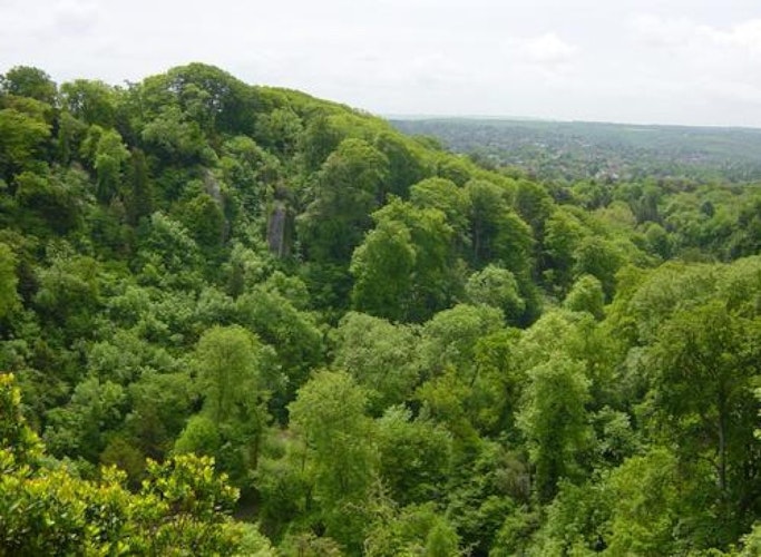
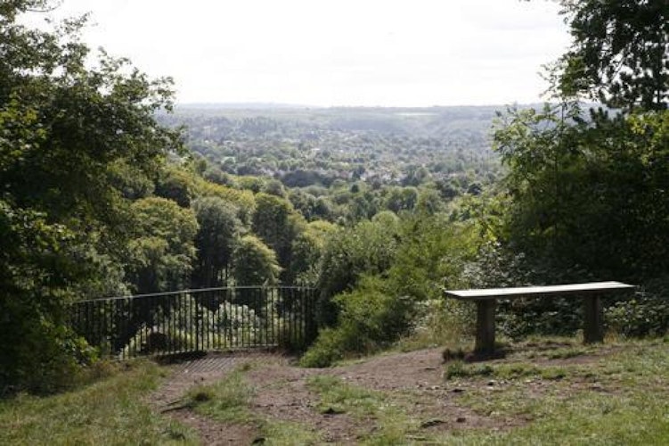
Topographically, the site is dominated by Blaise Hill, at the eastern end of a ridge which rises some 2.2km to the south-west as Kings Weston Hill. Hazel Brook enters the estate at the north-east, 200m north-east of the House, and runs south-west through a gorge bounded on either side by high ridges with limestone outcrops. From Blaise Castle there are spectacular views south-west towards the Avon, while from the ridge of Kings Weston Hill there are northward views to the Severn and the Welsh hills.
Blaise Hamlet (c 0.8ha) is now separated from the rest of the estate by suburban development but occupies a clearly defined enclave c 300m north-west of the House.
Entrances and Approaches
A service drive c 50m long, now the main vehicular approach to Blaise Castle House, approaches the House from the north-west, past a stable courtyard designed by William Paty (1801, listed grade II), arriving at a forecourt on the north-west front. A long, winding drive enters the estate from Henbury Hill, 750m south-east of the House.
The entrance is marked by a castellated lodge designed by Humphry Repton (1798-9, listed grade II*) but built as a mirror image of the drawing in the Red Book. Some 380m west-north-west of the Gothic Lodge the approach passes Timber Lodge (early-mid C19, listed grade II*), a thatch-roofed cottage naturelle clad in bark and ivy thrums, and after a further 200m passes Woodman's Cottage (1798, listed grade II) which was depicted in the Red Book.
Beyond this, the drive zig-zags down the steep east side of the gorge, crossing Hazel Brook by a stone bridge 350m south of the House (c 1798, listed grade II) before turning northwards along the west bank of the brook and through a cutting between lawns to the House. Part of this drive was diverted c 1820, or possibly by G S Repton when he was working at Blaise Hamlet in 1812, from H Repton's designed approach c 200m inside the entrance gate, running c 20m south of it before re-joining it north of the Woodman's Cottage. Repton describes the construction of his approach in the Red Book for Burley-on-the-Hill (1796):
'At Blaise Castle... I have lately finished one of the finest approaches in the kingdom; altho' for many hundred yards the sides of the hills were so steep, that I had to be let down by ropes to mark the line of the road'. (Humphry Repton 1796)
The line of this earlier approach is still traceable as low earthworks and is marked by plantings of beech and lime with northward views framed by Scots pine and yew trees. A second approach, now a footpath but formerly a carriage drive (c 1812), runs along Coombe Dingle, entering the estate outside the land here registered some 1.5km south of Blaise Castle House, and following Hazel Brook along the rear of early C20 properties in Pitchcombe Gardens for c 300m before entering the gorge.
Principal Building
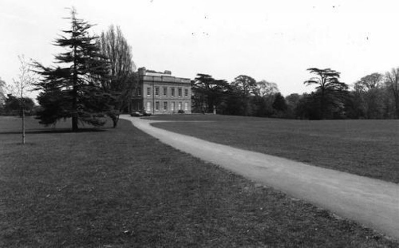
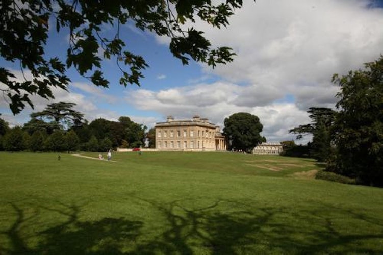
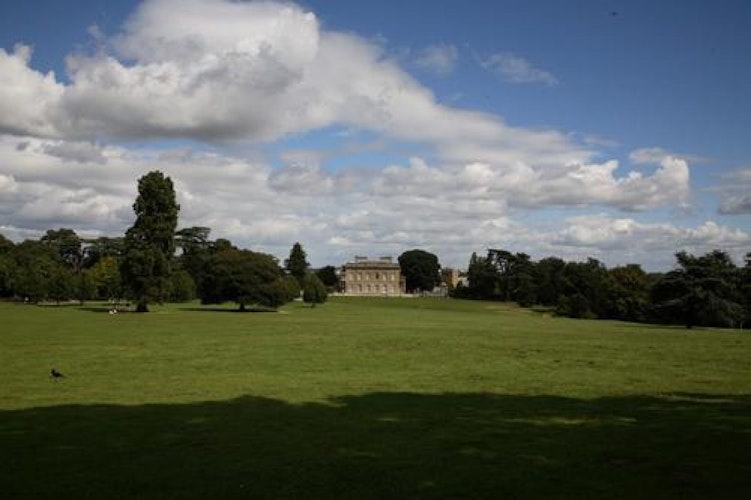
Blaise Castle House (1795-9, listed grade II*) was built for John Scandrett Harford by the Bristol architect, William Paty. It is situated just a few metres north-east of the site of the old manor house occupied by Thomas Farr, in the north-east corner of the site. It is located on the south side of the village of Henbury and commands open views into the park to the south-west of Blaise Hill and its foreground, and to the south of the valley of the Hazel Brook. Former views to parkland south-east of the House are largely obscured by self-sown trees in the valley of Hazel Brook.
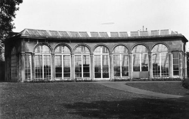
Humphry Repton advised on the siting of the new house, which is in accordance with the Red Book (1796). Paty's design for J S Harford was a two-storey box in a plain, Classical style with only a six-column Ionic porch on the north-east side as relief. Nash added a curved orangery (1806, listed grade II) to the east of the House. Work by Cockerell was largely to the House interior but included a link from the House to the orangery, as well as a terrace, balustrade, and Coade stone urns south and west of the House (1831-2, listed grade II).
Gardens and Pleasure Grounds
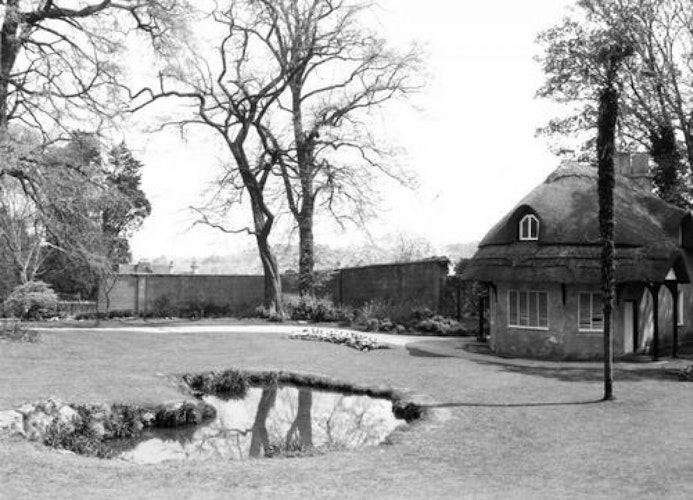
Immediately east of Blaise Castle House, and overlooked by the orangery, stands a thatched dairy (Nash c 1804, listed grade II*) with a small pool in front, in a C19 garden enclosure. Some 40m north-west of the House is a stone seat (Cockerell 1832, listed grade II) constructed to look along a double elm avenue planted by Sir Samuel Astry (late C17), of which survivors were still standing as late as the 1970s. Part of this avenue has been replanted (late 1990s) with lime trees as part of a restoration programme.
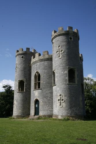
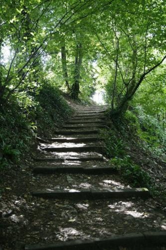
The pleasure grounds, as defined by the walk shown on Repton's plan in the Red Book, are laid out between the House and Blaise Hill. Some 200m south of the House the ground falls sharply to the Hazel Brook and footpaths follow the remains of a compact network of terraced walks and viewpoints, overlooking the brook. Approximately 120m due south of the House, is the levelled site of a root-house built for Thomas Farr. The prospect tower, Blaise Castle, 450m south-west of the House, is approached via two walks, one leading round the north side of the Hill, the other around the south side overlooking the gorge.
The latter passes Robber's Cave (listed grade II) and a viewpoint, Lover's Leap, 500m south-west of the House, constructed after the demolition of Farr's bastions as part of Repton's improvements in the late 1790s. The former, known as the Vista Walk, runs c 400m along the north side of the Hill before turning and climbing south-east and east to approach the Castle (1766, listed grade II*) from the west, via another of Farr's bastions, and following the line of a substantial rampart of the Iron Age hillfort.
On the summit of the Hill, in a lawn fringed with Scots pine, Corsican pine, and oak trees, stands the Castle which is now a shell but in 1919 was furnished on the first floor as a dining room for excursions from the House. The Castle was designed as an eyecatcher in views around the landscape and as a prospect tower from which Farr and his guests could watch the shipping in the Bristol Channel.
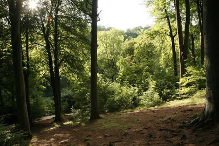
The pleasure grounds also include a walk south along Hazel Brook to a circular bath-house, c 600m south of the House, the foundations of which survive and are known locally as the Giant's Soap Dish. The brook contains remnants of Farr's ornamental stonework, including small cascades and footbridges. Some 30m north of the carriage bridge which carries the Repton approach over the brook, stands Stratford Mill (listed grade II), re-erected here from the Chew Valley in Somerset when the valley was flooded for a reservoir in the 1950s. Both sides of the gorge feature extensive hanging woods, predominantly of beech trees, and on the east side the high ground is characterised by limestone outcrops, the largest of which, Goram's Chair, is a feature of the sublime and picturesque views from Blaise Hill.
Some 700m south-west of the House is Arbutus Walk, laid out in the mid C19, which runs north/south along the east slope of Kings Weston Hill. On the north-facing slope of a ridge to the east of Hazel Brook is Rhododendron Walk (c mid C19), c 450m south of the House.
Park
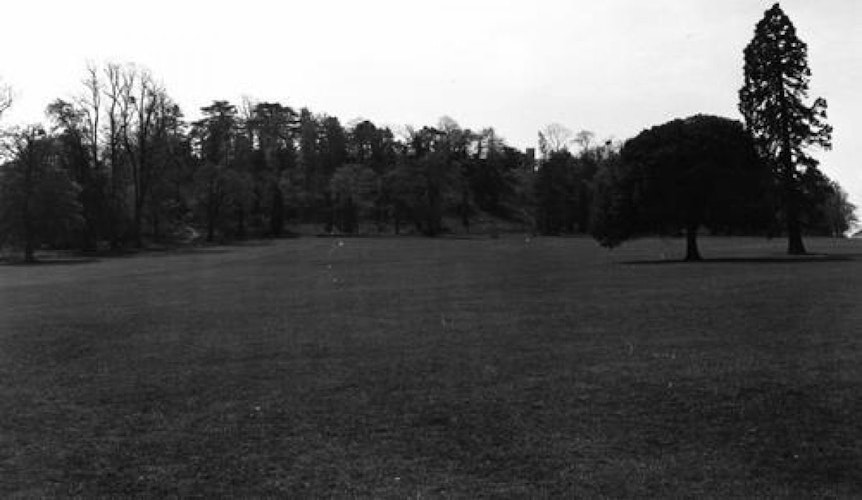
Fairly level and open parkland lies north and west of Blaise Hill, south of Kings Weston Road, and to the south-east of the House, east of Hazel Brook. The latter is known as the Royals and was an important middle ground in views from Repton's approach; in it there are vestiges of early C19 planting. There is more open parkland c 600m south of the House, now partly used as a golf course, which climbs a hillside to the boundary of the site here registered at the summit of Coombe Hill. Footpaths follow former carriage drives to the south-west, connecting the Blaise and Kings Weston estates via Echo Gate, 700m south-west of the House. The park is dotted with occasional specimen trees, including a Wellingtonia, cedars of Lebanon, an Atlantic cedar, and a holm oak.
Kitchen Garden
A brick-built kitchen garden (c 1800, listed grade II) stands c 50m north-east of the House. A large number of mid C20 glasshouses, built as part of Bristol City Council's nursery system, are mostly derelict although some are still in use by Cannington College.
Other Land
Blaise Hamlet, which Pevsner (1979) described as 'the ne plus ultra of picturesque layout and design' is located some 300m north-west of Blaise Castle House, and is now approached from Hallen Road. A footpath leads from the gate in the east boundary wall up six steps and through a shrubbery belt to the Hamlet's central green. To the south it is contained by a wall of 1812 (listed grade II).
The Hamlet, which extends to approximately 0.8ha, was laid out and built in 1812 to designs by Nash in response to a commission from J S Harford to build nine estate cottages for former estate workers and employees. Each cottage (all listed grade I) is different, but with common design motifs, such as the tall chimneys, dormer windows, and overhanging eaves. A terraced walk runs past and links each cottage. The cottages are irregularly spaced around the undulating green which has a sundial and pump in the middle (1815, listed grade I). Nash's scheme included planting proposals to clothe the walls and porches of the cottages.
Additional Research
Blaise Castle House is at the northern corner of the site. From the terrace the view to the south-west is of grassland to Castle Hill, on top of which stands Blaise Castle. From Castle Hill there are views to the north and west over the Severn estuary. To the south the views extend over the deep gorge of the Hazel Brook to the countryside beyond.
From Castle Hill one can descend westwards through the Echo Gate, climb up onto the ridge and walk for several miles along King's Weston Hill. Repton's Carriageway Drive descends and ascends the Hazel Gorge. The drive to Combe Dingle follows the Hazel Brook, taking one past many of the picturesque features. There are many paths through the woods and across the open spaces.
The site is generally well-maintained by Bristol City Council. The castle has been vandalised and in need of urgent restoration work. In addition several trees to the north-east of the castle have been recently felled, meaning that the castle is open to view from the house. This is not in keeping with Repton's vision. He wanted the castle to be romantically hidden by trees and approached gradually by the winding walks.
Description written: October 2002
Edited: September 2003
- Visitor Access, Directions & Contacts
Access contact details
The gardens are open every day throughout the year.
Directions
The gardens lie just south of the B4057 Kings Weston Road.
- History
The occupation of this site dates back to an Iron Age hillfort on Castle Hill. Of the medieval manor house of Henbury nothing now remains. It was demolished on completion of Blaise Castle House.
In 1688 Sir Samuel Astry inherited the estate. He built the great house (remodelled in the early 19th century) and laid out an enclosed park. A significant feature of the design was a double avenue of elms (now demolished) crossing the parkland from the foot of Castle Hill. This led to an area which is now the site of the Blaise Castle House stables. Around the house were formal parterres. The estate passed through a number of hands over the course of the next century.
In 1762 Thomas Farr, a Bristol merchant, bought 45 hectares of the estate for a country retreat. He planned to develop the park as a pleasure ground. He planned walks around Castle Hill, built the castle and landscaped the hill as ramparts. However, Farr lost money through the American War of Independence and was forced to sell the property.
In 1789 the estate was bought by John Harford. He was a Bristol Quaker and director of the Harford Bank. Harford commissioned William Paty to design Blaise Castle House and Humphry Repton to improve the park. The estate's natural features and Farr's earlier attampts at landscaping lent themselves to Repton's style of picturesque landscaping
John Nash, who had business connections with Repton also did some work for Harford. Harford's son succeeded to the estate in 1815. He commissioned Charles Cockerell to design an exhibition room in the house. This was to display the pictures and statuary he had collected on his Italian travels. In 1926 the estate was sold to Bristol Council.
The following is from the Register of Parks and Gardens of Special Historic Interest. For the most up-to-date Register entry, please visit the The National Heritage List for England (NHLE):
www.historicengland.org.uk/lis...
HISTORIC DEVELOPMENT
Domesday refers to a wood one mile square in the manor of Henbury, held by the bishops of Worcester. There are traces of ancient woodland on the estate, with ridge and furrow and old field boundaries in the parkland south of Blaise Castle House and the remains of an Iron Age hillfort on Blaise Hill.
After the Dissolution, and the seizure of the estate by the Crown, Henbury was granted to Sir Ralph Sadlier, of Standon in Hertfordshire. Henbury was sub-let by the Sadliers until they sold it in lots in 1675. A substantial part was purchased by Sir Samuel Astry, whose father-in-law, George Morse had built a house, known as Henbury Great House, on land in the village purchased from the Sadliers some ten years earlier. After Morse's death in 1688, Astry took over and enlarged the house and made formal gardens to the north, and planted a double avenue to a summerhouse on the top of Blaise Hill. The whole layout is depicted in an engraving by Kip published in 1712 (Atkins 1712).
After Astry's death, the manor passed via the Earl of Suffolk who had married one of Astry's daughters, to the Smyths of Ashton Court, Avon. Athough they held the estate until 1760, they sold the Great House in 1730 and it was finally demolished in the 1830s.
In 1762, Thomas Farr, a wealthy Bristol sugar-merchant, bought 110 acres (about 45 hectares) of the estate, comprising the old Manor House, then a gabled farmhouse (depicted in one of Repton's Red Book paintings), Blaise Hill, the land between the Hill and the village of Henbury, and Hazel Brook in its spectacular gorge. Farr was responsible for commissioning the London architect Robert Mylne (1733-1811) in 1766 to design Blaise Castle, a triangular prospect tower, designed to command views of the shipping in the Severn and the Avon. Farr created an elaborate pleasure garden, inspired by that of his friend Valentine Morris at Piercefield near Chepstow, designed to capitalise on the sublime qualities of the topography, with bastions, wooden cannon, and look-outs on Blaise Hill overlooking the gorge. He made cascades and pools in the brook, with a steam-engine designed to raise water to supply water-features in the gorge in which he built a bath-house and a root-house.
Farr went bankrupt in 1778 as a result of the blockade of shipping in the American War of Independence. The property was purchased by Dr Denham Skeet, who in turn sold it to the Bristol banker and Quaker, John Scandrett Harford, in 1789. Harford augmented the estate with further land purchases, including the east side of the gorge, and in 1795 commissioned a design for a new house, Blaise Castle House, from the Bristol architect, William Paty (1758-1800). At the same time, Harford invited Humphry Repton (1752-1818) to visit. Repton made two further visits in 1796 and a Red Book was completed the same year. After Paty's death in 1800, Repton's partner, the architect John Nash (1752-1835) became involved, designing an ornamental Dairy in c 1804, an Orangery in 1806, and picturesque cottages at Blaise Hamlet, completed in 1812. Repton's sons George Stanley Repton (1786-1858) and John Adey Repton (1775-1860) appear to have assisted Nash on these commissions.
After Harford's death in 1812, the estate was inherited by his son, John Scandrett Harford Jnr. G S Repton may also have given advice on the park and gardens in the period 1812-20. Charles Robert Cockerell (1788-1863) was commissioned in 1832-3 to work on the House and immediate surroundings. Further ornamental planting continued during Harford Jnr's lifetime.
J S Harford Jnr died in 1866, after which Blaise Castle ceased to be the family's principal seat. In 1926, the estate was purchased by the Bristol Corporation, excluding Blaise Hamlet which was bought by the National Trust in 1943. The Corporation opened the estate as a public park, and in 1949 the House as a museum. Under the Corporation's ownership, Blaise has served as a public park but with little alteration to its picturesque qualities.
Period
- 18th Century
- Late 18th Century
- Associated People
- Features & Designations
Designations
Conservation Area
- Reference: Henbury and Kingsweston & Trym Valley
The National Heritage List for England: Register of Parks and Gardens
- Reference: GD1446 4181
- Grade: II*
The National Heritage List for England: Listed Building
- Reference: Blaise Castle
- Grade: II*
Style
Picturesque
Features
- House (featured building)
- Description: The house was designed by William Paty for J.S. Harford. C.R. Cockerell remodelled part of the house between 1832 and 1833, adding an Exhibition Room. The house has a plain facade on classical lines. It now houses Blaise Castle Museum.
- Earliest Date:
- Latest Date:
- Garden Terrace
- Description: There is a terrace, balustrade and four vases around Blaise Castle House. These features were probably added during the time that C.R. Cockerell was working on the house.
- Earliest Date:
- Latest Date:
- Orangery
- Description: There is a simple, curved orangery built in 1806 by John Nash, in the position recommended by Repton.
- Earliest Date:
- Latest Date:
- Stable Block
- Description: This feature is a stable block completed in 1801. It is of plain Georgian design. There are three wings around a cobbled yard with a wall and gates to the front. There are stables in the north and south wings and a coach house in the east wing. The building is now used as storage by the gardeners.
- Drive
- Description: There is a drive past the stable block to the house. It has limestone rubble walls on either side.
- Earliest Date:
- Latest Date:
- Finial
- Description: There are two stone piers crowned by carved seahorse heads at the house end of the stable drive.
- Garden Seat
- Description: The seat was designed in 1832 by C.R. Cockerell as the terminal point for Sir Samuel Astry's double avenue of elms planted around 1700. The elms are no longer extant. There is a plain wall of Bath stone with a large niche containing a seat. This is crowned by a pediment.
- Earliest Date:
- Latest Date:
- Dairy
- Description: The thatched dairy is a tiny picturesque cottage ornee. It was used to house part of the museum, but is now closed.
- Earliest Date:
- Latest Date:
- Kitchen Garden
- Description: The walls relate to the old kitchen garden, which is now grass with a few trees. The walls remain, and are built of red brick.
- Earliest Date:
- Latest Date:
- Planting
- Description: The Dairy garden is a simple garden of sloping lawn, curving footpaths, some planting and a pond.
- Planting
- Description: The formal garden is a walled garden planted with roses.
- Gate Lodge
- Description: This is the entrance lodge and the gateway from Henbury Hill, which was designed by Repton to stand at the beginning of the carriageway drive. It accords in style with the castle rather than the house.
- Garden House
- Description: This is a timber lodge. It possibly dates to the mid-18th century, contemporary with the castle (1766). In character it is more suited to the Repton / Nash improvements, but is not mentioned by Repton in his Red Book. The feature is a 'cottage naturelle'. It consists of one storey and an attic, covered entirely in bark, roots and thatch.
- Earliest Date:
- Latest Date:
- Garden House
- Description: This is the Woodman's Cottage. It was created in 1798, being part of Repton's scheme described in his red book: 'The form of this cottage must partake of the scenery without meanness, it must look like what it is, the habitation of a labourer who has the care of the adjoining woods, but its simplicity should be the effect of Art and not of accident'. It has since been altered and trees now block the planned view of it from the house. Today it has a slate roof, but originally it was intended to be thatched.
- Earliest Date:
- Latest Date:
- Ornamental Bridge
- Description: This is a rubble bridge over the Hazel Brook at Stratford Mill. It was part of the works for the Repton carriageway drive of 1788-89.
- Earliest Date:
- Latest Date:
- Garden Building
- Description: This is Stratford Mill. It was brought in 1952 from its original site at West Harptree when the Chew Valley was flooded for a reservoir. It was probably a late 18th century corn mill. It now stands where the carriageway drive crosses the Hazel Brook. It forms a picturesque feature in keeping with Repton's design.
- Ornamental Bridge
- Description: This is the bridge at the Giant's Soap Dish. It was part of J.S. Harford's last scheme, the carriage drive to Coombe Dingle.
- Earliest Date:
- Latest Date:
- Ornamental Bridge
- Description: This is a bridge over the Hazel Brook, some 450 metres downstream from the bridge at the Giant's Soap Dish. It is a small rustic rubble bridge, a 20th century copy of the bridge at the Giant's Soap Dish.
- Ornamental Bridge
- Description: This is a further bridge over the Hazel Brook, some 650 metres downstream of the the bridge at the Giant's Soap Dish.
- Earliest Date:
- Latest Date:
- Folly
- Description: Blaise Castle, on Blaise Hill was built by Robert Mylne in 1766 for Thomas Farr. It is unusual for a mid-18th century Gothic folly in that it was built to be occupied. It was repaired in 1957 when all the interior features were removed. The structure comprises a circular tower with three attached battlemented turrets.
- Earliest Date:
- Latest Date:
- Grotto
- Description: This feature is known as Butcher's Cave. It is probably of the Repton period, though possibly of the Farr period. It is a cell in the hillside with an arched entrance.
- Grotto
- Description: This feature is known as the Robber's Cave. It is probably of the Repton period, though possibly of the Farr period. It is a 'natural' limestone cave.
- Drive
- Description: This is Repton's carriageway drive. Repton believed that one of the greatest improvements to the estate would be to remove the principal entrance from Henbury village 'where a number of Villas or large country houses seem to dispute with each other by their size and and cumbrous importance'. His hope was that 'the approach will be in strict character with the wildness of the scenery, and excite admiration and surprize'. Repton's spectacular drive begins at the eastern Henbury Hill entrance. It descends the wooded Hazel Brook Gorge by way of hairpin bends and passes. It crosses the Hazel Brook at Stratford Mill and then more gently climbs the other side of the Gorge. At the top it emerges from the woodland onto open grassland and sweeps around Blaise Castle House.
- Earliest Date:
- Latest Date:
- Walk
- Description: This rhododendron walk was possibly planted by J.S. Harford Jnr.
- Earthwork
- Description: There are the remains of Iron Age banks and ditches.
- Walk
- Description: Repton's Vista Walk winds around the remains of the Iron Age earthworks, linking the house and the castle.
- Prospect Mound
- Description: Lovers Leap: this is a viewpoint down the gorge to the Giant's Soap Dish and Goram's chair, and over to the countryside beyond.
- Drive
- Description: This feature is the carriage drive to Coombe Dingle. It follows the Hazel Brook from Stratford Mill to Coombe Dingle.
- Earliest Date:
- Latest Date:
- Earthwork
- Description: Goram's Chair is a limestone outcrop on the south side (Coombe Hill) of the gorge.
- Pool
- Description: This feature is the Giant's Soap Dish. It is a small pool near the bathing pool.
- Earthwork
- Description: This feature is Goram's Footprint, a 'footprint' in stone.
- Pool
- Description: This feature is the bathing pool, a pool made in the Hazel Brook.
- Plantation
- Description: There is a plantation of beech trees on Coombe Hill just beyond Goram's Chair.
- Earthwork
- Description: There are earthworks on the top of the ridge between Limkiln wood and Alderdown wood.
- Stream
- g
- Parkland
- Key Information
Type
Estate
Purpose
Ornamental
Principal Building
Education
Period
18th Century
Survival
Extant
Hectares
100
Open to the public
Yes
Electoral Ward
Henbury
- References
References
- List of Buildings of Special Architectural Interest, City of Bristol, Avon
- Hebditch, Max {Blaise Castle House Museum} (Bristol: City Museum, 1971) Blaise Castle House Museum
- Temple, Nigel Hal Longdale {John Nash and the Village Picturesque} (Gloucester: Alan Sutton, 1979) John Nash and the Village Picturesque
- Hallen and Henbury Women's Institute {A Guide to Henbury} (1958) A Guide to Henbury
- Hartford, John {Harford papers} Castles in Kent
- Pevsner, N. {The Buildings of England: North Somerset and Bristol} (Harmondsworth: Penguin, 1958) The Buildings of England: North Somerset and Bristol
- G Carter et al, {Humphry Repton} (1982), p 152 Humphry Repton landscape gardener 1752-1818
- {English Heritage Register of Parks and Gardens of Special Historic Interest} (Swindon: English Heritage 2008) [on CD-ROM] Historic England Register of Parks and Gardens of Special Historic Interest
- Daniels, S {Humphry Repton} (1999), pp 48-9, 230-5 Humphry Repton
- Nicholas Pearson Associates {Blaise Castle Estate Historic Landscape Survey and Management Plan} (1993) Blaise Castle Estate Historic Landscape Survey and Management Plan
- Atkyns, R., (1712), pp 473-4 The Ancient and Present State of Gloucestershire
- Kingsley, N., (1992), pp 79-81 The Country Houses of Gloucestershire, Vol. II 1660-1830
- Mowl, T., (2002), pp 109-13 Historic Gardens of Gloucestershire