Introduction
This is a park of 140 hectares laid out by Thomas Wright in the 1750s and 1760s around a country house. Stoke Park is of considerable interest as the best documented and most complete surviving landscape design by Thomas Wright. The parkland and woodland have recently undergone partial restoration as public open space.
Terrain
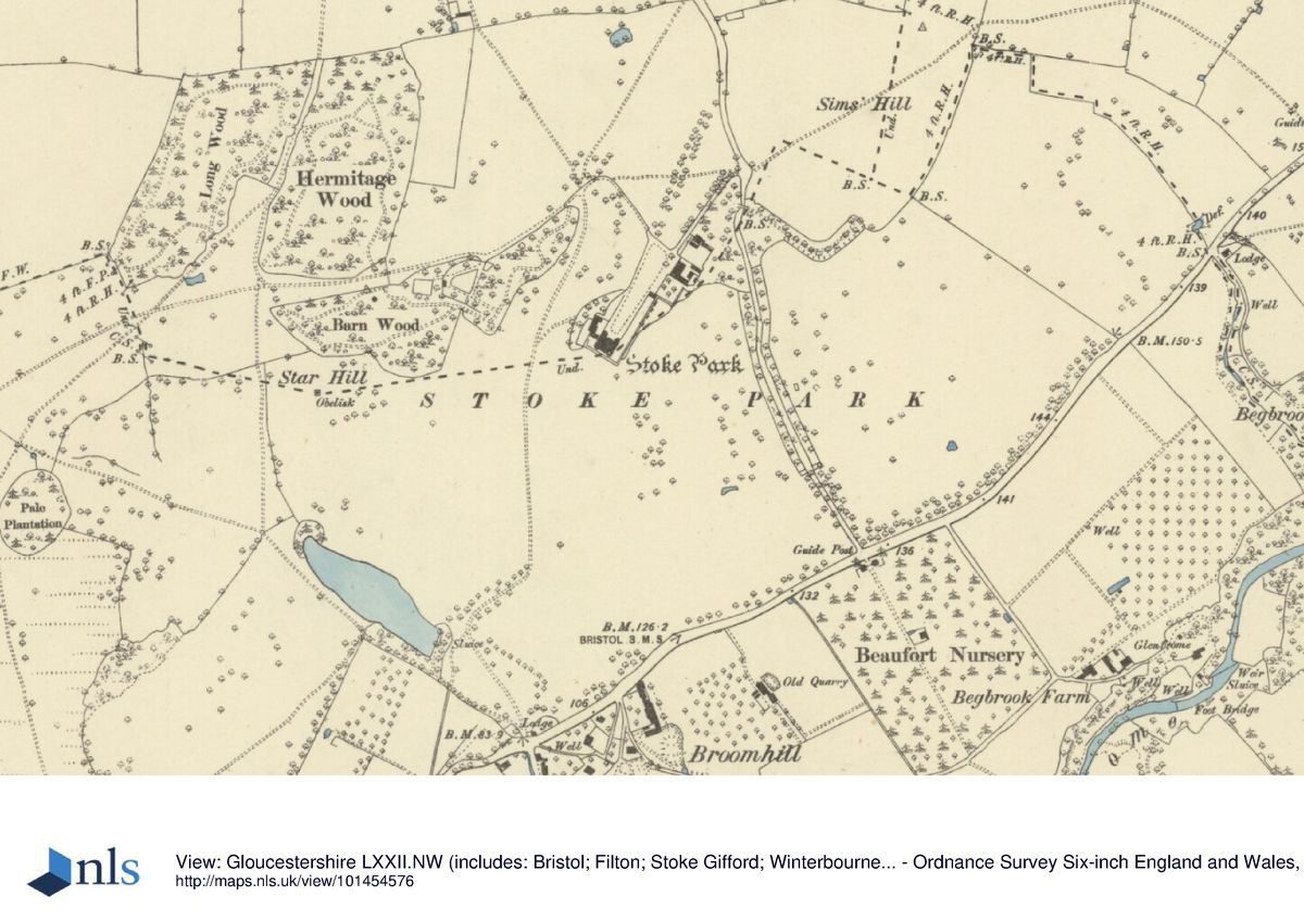
The park occupies the scarped and indented eastern flank of Purdown, a ridge of lias limestone rising to about 90 metres above sea level and commanding wide views.
Stoke Park and Purdown lie on a long, prominent ridge which extends a green finger into the heart of the Bristol urban area. The ridge can be seen from most areas of north-east and north-central Bristol.
The landscape of Stoke Park itself extends from the ridge top down its south-eastern flank, forming an intimate park as a counter-point to the wild and remote nature of Purdown as a whole. The Dower House, standing on its dramatic pedestal, dominates the undulating slopes and the parkland floor.
The house and garden are a prominent landmark to motorists entering or leaving the city via the M32. The woodland crowning the hilltops provide a backdrop to the house and park and do much to enhance the illusion of a rural setting.
The principal entrance to the house is from Coldharbour Lane, through the hospital complex. Carriageways to the house enter the park via the gate at Stapleton and from the rear of Romney Avenue, along the high ground near the summit of the ridge.
Much of the landscaped grounds of Stoke Park survive today. Major built development has been confined to the area north-west of the Dower house. The most significant changes to the parkland occurred in 1968 when the M32 Parkway was routed through the park's foreground and Duchess Pond was filled in.
Since the 1950s the park has suffered an uncertain management policy with consequent decay and dereliction. The future is equally uncertain. Due to the implementation of the ‘Care in the Community' policy, the land has become surplus to requirements and the district health authority has sought planning approval for housing on some of the area. Basic maintenance has ceased to be conducted.
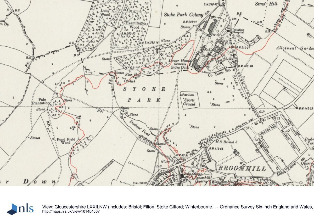
The Dower House is redundant, used only for residual administrative functions. It has permanent scaffolding to hold the stucco in place. The balustrade is collapsing and absent in places. The orangery appears sound. The obelisk on Star Hill in now a 6 metre stump, devoid of its ashlar facing and inscription. The gateway at the south-west entrance on Frenchay Park Road has recently received some remedial attention to the stonework and new wooden gates have been erected.
The sarcophagus known as Mathilda's Tomb has been badly vandalised, and the stone is scattered around. The other woodland features, the stone-built tunnels and collection pond are in sound condition, though the water feature clearly has not been functioning for some time. The connecting ditches are blocked and overgrown, as is the pond overflow.
The long barrow has recently been the subject of an excavation and has not been rebuilt in the excavated section. The soil has been thrown back randomly. The site of Duchess Pond has been partly dug out to provide fishing for an angling club.
The park and woodland share with the individual features an air of long neglect and lack of maintenance. However, the unusual nature of its landform means it retains its distinguished character of ruined grandeur.
The following is from the Register of Parks and Gardens of Special Historic Interest. For the most up-to-date Register entry, please visit the The National Heritage List for England (NHLE):
www.historicengland.org.uk/lis...
An 18th century park laid out by Thomas Wright between 1748 and 1766 around a country house.
DESCRIPTION
LOCATION, AREA, BOUNDARIES, LANDFORM, SETTING
Stoke Park occupies a wedge of open land extending from 2km to 5km north-east of the centre of Bristol. The 140ha park occupies the scarped and indented eastern flank of Purdown, a ridge of lias limestone rising to c 90m above sea level and commanding wide views over Kingswood, Bristol and the valley of the River Frome. The park retains its open character but is now surrounded on all sides by housing and other development and is divided by the M32 motorway. The park is bounded to the north by fences and a stone wall from a cycle track which marks the southern boundary of the grounds of the University of the West of England. The west boundary is formed by the back gardens of houses on Romney Avenue, the south-west boundary by public open space and the boundary wall of Heath House, and the south-east boundary by the M32 motorway and Frenchay Park Road. The southern end of the east boundary is formed by Stoke Lane which becomes Coldharbour Lane to the north. The former hospital site to the north-east which has been developed for housing is excluded from the site here registered. Although missing some key landscape features and compromised by its poor condition and the intrusion of the motorway, Stoke Park is of considerable interest as the best documented and most complete surviving landscape design by Thomas Wright.
ENTRANCES AND APPROACHES
There are three main historic entrances. From the north-east is the earliest entrance, which was associated with the Elizabethan house, a direct c 400m drive from Coldharbour Lane which follows one arm of two former diverging avenues radiating north-eastwards from Stoke Park House. The line of this avenue remains and has recently been replanted (2002) and now passes through a new housing development west of the Clock Tower (c 1930s) erected to the memory of the Rev Harold Nelson Burden who founded the Stoke Park Colony. It then passes the western edge of a lawn, formerly a bowling green, to approach the north-east front of the House. Two serpentine drives were laid out between 1725 and 1768, approaching from Bristol to the south-west and from Stapleton to the south. The first is an extension of a public footpath, formerly a drive, called Sir John's Lane which runs along the top of the Purdown Ridge, entering Stoke Park c 25m west of Purdown Camp (scheduled ancient monument) which was used as an anti-aircraft gun site (1940). The drive provides a variety of extensive views over the park and the surrounding countryside to the east and glimpsed views of the House to the north-east. It passes through the remains of Purdown Camp and, after c 400m, curves to the north, west of Pale Plantation, and follows a mid C20 fence line to a mid C20 gateway where it turns north-east through parkland on the top of the ridge, then east between Hermitage Wood to the north and Barn Wood to the south, before turning south to meet the north drive c 100m north of the House. The south-east drive enters the park at Duchess or Broomhill Gate (Wright 1768, listed grade II) at the junction of Park Road, Broom Hill, and Frenchay Park Road, 600m south of the House. It proceeds in a cutting 200m in a north-westerly direction, through a subway under the M32 (1968) and turns north through the park at the eastern end of Duchess Pond. It passes below the south-west revetment of the House and meets the south drive 50m north-east of the north-east edge of Barn Wood. The C18 gates of Duchess Gate were removed to Badminton in 1908, where they were re-erected at the entrance to Kennel Drive. These gates were copied in the restoration of Duchess Gate by the Stoke Park Restoration Trust (1988-96). There are numerous informal access points to the park, particularly from the west along Romney Avenue.
PRINCIPAL BUILDING
Stoke Park House (listed grade II*) stands on a massive stone-revetted and balustraded terrace (listed grade II) built for the 1563 house at the end of a narrow promontory. The terrace links the House to the Orangery (c 1720, listed grade II). The Elizabethan house faced north and provided no windows to exploit the extensive views to the west and south. By 1712 two stairwells had been extended above the roofline to form towers topped with viewing platforms. Further alterations followed, to the designs of Thomas Wright. In the first phase from 1749 to 1752, single-storey octagonal rooms linked by an arched loggia were added at the south-east and south-west corners. Visiting in 1755, Lady Anson, Duchess of Northumberland described the view from these rooms as 'such a more than semi-circle of Prospect, surpassing the richest as well as the greatest Views I ever saw' (quoted in Harding and Lambert 1994). In the second phase, from 1760 to 1764, these octagonal rooms were built upwards to form three-storey towers, with matching towers at the north-east and north-west corners. The whole Elizabethan house was then encased in walls with rearranged classical fenestration and the gable ends of the pitched roofs hidden behind crow-step crenellations. The reformed house has been described as 'the first true creation of the conscious Jacobethan revival' (Mowl 1993). The House was externally restored and converted to apartments in 2002. Stoke Park House and its immense platform is the dominant visual feature in the landscape.
GARDENS AND PLEASURE GROUNDS
Around the south-west and south-east fronts of the House is a terrace, protected from the precipitous drop by a stone balustrade. The terrace leads north-east to the pavilion or Orangery, converted to a chapel for hospital use and currently undergoing restoration (2002). The area north of the Orangery is extensively developed with hospital buildings and car parks and is currently undergoing redevelopment (2002). In the Thomas Wright layout access was gained through the Orangery, then known as Summer Hall, to a sequence of gardens and pleasure grounds to the north-east. A path led through a square enclosure with an oval planted mound called the Oval Garden, immediately north-east of the rear of the Orangery, and along the eastern edge of the escarpment, formerly known as Stable Hill, to some lawns ornamented with shrubberies. West of this path, c 200m north-east of the House, were the Stables and the Kitchen Garden of which no trace remains. The path continued to the west side of Coldharbour Lane where a stone-built abutment is all that remains of a crenellated stone bridge (Wright 1761-2) which formerly linked the gardens north-east of the House to an extensive L-shaped viewing terrace on Sims Hill, each side of the 'L' being c 100m long. The bridge was removed for road-widening in the 1970s. Sims Hill, formerly Simon's Hill, provides views to the north and north-east which are not attainable from the House. The terrace, with its mature Turkey oaks from the Thomas Wright design, survives in an overgrown condition. The three woods, Barn Wood, Hermitage Wood, and Long Wood, which straddle the ridge to the west of the House, contain the remains of a footpath system which gave access to the woodland gardens. These, and the features within them, were linked to each other by serpentine paths, with the entrance to the circuit at the north-east point of Barn Wood, close to where the drives from the south and south-west meet. Previously overgrown and largely impenetrable, the path network is currently undergoing a partial restoration. Barn Wood contains the Beaufort Memorial (Wright 1756, listed grade II), the cold bath (Wright c 1750, listed grade II), a stone tunnel (Wright c 1750, listed grade II), and the surviving footings of the Rotunda (Wright 1755-6). In Hermitage Wood, yew trees mark the site of Bladud's Cell (Wright 1750), a root house which has disappeared. Hermitage Wood is linked to Long Wood via a partially derelict stone tunnel with rusticated entrance arches (Wright c 1750, listed grade II) which runs beneath a track. The path in Long Wood emerges at the south-west corner, affording wide views to the south and east across Bristol. The Wright 'Wood Walks' were Stoke Park's most celebrated feature. Mason (1795) said of them:
'the pieces of woodland... are neither remarkable for extent in themselves, nor for the size of their timber; yet the management of them gave me, more than anything I had seen, an idea of what might be done by the internal arrangement of a wood'.
Laird (1999) describes their floristic elaboration in detail, describing Wright's improvements at Stoke as 'a very complex horticultural intervention'. The circuit of the park, as described by Bishop Pococke (1764), commenced with these woodland gardens, the winding walks taking in the features mentioned above. A recent survey (LUC 1992) identified many beech and horse chestnut trees surviving in Barn Wood and thirteen widely spaced mature planes in Hermitage Wood, in a large circle centred on the site of Bladud's Cell, from the Thomas Wright period. There is no trace of the 'Saloon of Oaks' in which the Rotunda once stood (Russell 1988).
PARK
The main area of the park lies west and south of the House, occupying the dramatically undulating ridge to the west, the slopes and valleys leading eastwards down from the ridge, and the parkland floor to the south. The ridge top with its carriageway offers many and varied views of the park and wider landscape. On Star Hill, a spur of the main ridge, sit the remains of the Obelisk (Wright 1761-2, listed grade II) which was erected to the memory of Norborne Berkeley's niece, Caroline, who, according to the inscription, 'died here'. On the edge of a steep escarpment 1km to the south-west of, and facing the House across the park is the site of the now lost Tomb of the Horatii and Curiatii (Wright 1762-4), modelled on an ancient mausoleum at Albano, near Rome. Below and east of this lies Pond Field Wood, and in a fold of the ridge to the north lies Pale Plantation (c 1745), the first ornamental woodland to be planted at Stoke by Berkeley. In the valley bottom 500m south-west of the House is Duchess Pond (1768). The original pond was the last ornamental feature to be added to the landscape. It was infilled for the construction of the M32 motorway in 1968 but was recreated in a slightly adjusted position by the Stoke Park Restoration Trust between 1988 and 1996. Some 300m due south of the House is an area of parkland (c 30ha) which is physically but not visually disconnected by the M32 motorway. This area retains its C18 boundary planting of beech, horse chestnut, lime, and oak.
KITCHEN GARDEN
The kitchen garden was located 200m north-east of the House, next to the stables on Stable Hill. This area was completely redeveloped for hospital use in the 1930s and no trace of the kitchen garden survives.
REFERENCES
R Atkyns, Ancient and present state of Glostershire (1712), p 690
L Knyff and J Kip, Britannia Illustrata 2, (1715)
T Wright, Arbours and Grottos, 1755 and 1758 (reprinted 1979, edited by E Harris)
G Mason, An Essay on Design in Gardening (2nd edn 1795), p 117
Country Life, 181 (7 May 1987), p 119; no 15 (14 April 1988), pp 132-5
J R Russell, Three Garden Buildings by Thomas Wright in Stoke Park, Bristol (1988)
Garden History 17, no 1 (1989), pp 68-82; 24, no 1 (1996), p 133
Bristol and Avon Archaeology 8, (1989), pp 30-40
M Batey and D Lambert, The English Garden Tour (1990), pp 200-3
Stoke Park Restoration Plan, (Land Use Consultants 1992)
S Harding, Conservation issues in the disposal of National Health Service land, (unpublished doctoral thesis, University of the West of England 1993), pp 87-158
T Mowl, Elizabethan Jacobean Style (1993), pp 197-8
S Harding and D Lambert, Parks and Gardens of Avon (1994), pp 39-41, 105-6
M Laird, The Flowering of the Landscape Garden (1999), pp 88-98
Maps
J Vascon, Survey of Stoke Park, 1725 (D2700), (Gloucester Record Office)
S Cook, Survey of Stoke Park, 1749 (D2700), (Gloucester Record Office)
J Blandford, Survey of Stoke Park, 1768 (D2700), (Gloucester Record Office)
OS 6" to 1 mile:
2nd edition published 1904
1921 edition
Archival items
The Beaufort archive is held at the Gloucester Record Office (D2700).
The Stoke Gifford Estate Papers are held at the Badminton Muniment Room, Badminton House, Glos.
R Pococke, Travels of Dr Richard Pococke Bishop of Osary in 1764 (British Museum Add MS 14), pp 260-1
Set of six postcards published by Avon Gardens Trust (c 1988)
Description written: August 2002
Register Inspector: SH
Edited: November 2002
- Visitor Access, Directions & Contacts
Access contact details
The site is redundant hospital land but is crossed by a number of public footpaths.
Owners
Frenchay Health Authority
- History
The manor of Stoke Gifford was formed by the sub-division of the Manor of Barton Regis (The King's Farm) and was granted by William the Conqueror to Osbern Gifard. His descendant, John Gifard, died a rebel-in-arms in 1327. The estate was confiscated, but held as a dowry by Margaret Gifard until her death in 1338. At this time Maurice de Berkeley gained possession.
Upon the dissolution of the monasteries, Sir Richard Berkeley was able to extend the Stoke Gifford estate by buying lands in Stapleton. In 1563 he began the building of a new manor house on the present Stoke Park site, which became the seat of a ‘cadet' branch of the family.
Kip's print of 1712 shows the Elizabethan manor house on a great artificial platform. The sides were (and still are) crowned by an arched balustrade. The present house was re-designed and extended for Norbonne Berkeley (later Lord Botetourt) with a curious mixture of classical and gothic elements in 1760-64. The work appears to have been carried out by James or Thomas Paty. However, plans and elevations for the crenellated parapets, the octagonal rooms at the south-east and south-west, and the porticoed loggia in the hand of Thomas Wright exist among the Badminton muniment (see references).
It is known that Thomas Wright laid out the garden at Stoke Park from 1750 onwards. His involvement was such that he had a permanent apartment there, and he continued to visit and advise long after Botetourt's death in 1770. At this time the estate passed to the Beaufort family, through his sister's marriage.
George Mason, in his ‘Essay on Design in Gardening' (1795) says of Stoke that it "gave me more than anything I had seen an idea of what might be done by the internal arrangement of a wood. Some old pollards were made admirable use of. One of these sylvan spinnies was decorated with roses, as nearly as possible in the very manner advised in the fourth book of the English garden" (Rev. W. Mason, 1772).
Apart from a grove of ancient yews in Hermitage Wood the planting has long since been lost, though meticulous lists of plants brought in from Badminton and nurserymen from London survive in the Gloucester Record Office. There is also a ‘Plan of the wood walks at Stoke with Designed alterations' (see references).
The remainder of the park was laid out in a way that foreshadowed the style of Lancelot Brown. Trees were planted in informal groups on the slopes around the house. It is clear from Wright's letters that his concern with the appearance of the house extended only to its south-west aspect, as the sides were to be screened by planting. An artificial lake was created by damming a small stream.
George Mason considered Thomas Wright to have been the only landscape designer of genius to have come between William Kent and Capability Brown. He was, we are told, an ‘invoker of simplicity'. Garden ornaments were few. There was only a small arbour in a wood known as 'Bladud's Temple', 'a rotunda which Wright ordered to be removed in 1777' and an obelisk. The features of the woodland walks have been overlooked by previous researchers.
Recent research has indicated that there were more garden structures than had been previously thought, and these were of a more diverse nature. These were likely to have been to the design of Thomas Wright. There is now a clearer picture of a clasically ornamented parkland with intensive design of the woodland and landscape.
A painting of ‘Stoke Gilfort in Gloucestershire' , created in 1774 by John Wootton is reproduced on a Wedgewood dish, one of a 952-piece service commissioned by Empress Catherine II of Russia. This is currently on display at the Winter Palace, Leningrad. It shows Duchess Pond in the foreground with the Dower House beyond, overlooking a picturesque landscape.
Norbonne Berkeley, by then Lord Botetourt, was appointed Governor of Virginia in 1768. He died there in 1770 leaving his Stoke estate to his sister, Elizabeth. Stoke's principal use from this time was as a Dower House to Badminton. In 1907 the 10th Duke of Beaufort sold the estate to the Reverend Harold Nelson Burden, who converted the house to serve as the nucleus of a hospital for the mentally troubled.
The Stoke Park Colony opened on April 1st, 1909, becoming the pioneer research establishment into mental illness. It was the first such institution to be certified under the Mental Health Act of 1913. The Stoke Park Group of Hospitals continued under the NHS. Recently, the ‘Care in the Community' programme has meant a contraction of its role. Preparations have been made by the Health Authority for the disposal of Stoke Park.
In 1968, the M32 Parkway was built through the foreground of the park. Duchess Pond was drained and filled in at this time, although the road does not actually cross the lake area. A film made by the Stoke Park Management Committee provides a valuable record of the park's appearance before the more recent neglect.
The following is from the Register of Parks and Gardens of Special Historic Interest. For the most up-to-date Register entry, please visit the The National Heritage List for England (NHLE):
www.historicengland.org.uk/lis...
HISTORIC DEVELOPMENT
The Berkeley family of Berkeley Castle, Gloucestershire, gained possession of the manor of Stoke Gifford about 1338. Stoke Park House was built in 1563 by Sir Richard Berkeley, who succeeded to the estate of the Stoke Gifford branch of the family in 1553. The family prospered from ownership of the parish of Stoke Gifford and parts of the parishes of Winterbourne, Frampton Cotterell, Filton, and Stapleton and, in the late late 17th and 18th centuries, from coal-mining liberties in Kingswood Forest. The Stoke Gifford estate passed through several generations of the family. Between 1712 and 1725, John Symes Berkeley (d 1736) commissioned Sir James Thornhill to rebuild a summerhouse at the end of the terrace as a classical pavilion or orangery. He also had rides cut through the woodland.
John's son, Norborne Berkeley, Lord Botetourt (1717-70) remodelled the house and established the current structure of the landscape with the assistance of Thomas Wright of Durham (1711-1786). Norborne was bankrupted through investments in Champion's Brass Works at Warmley House, Avon. In 1768 became Governor of Virginia, where he died in 1770. He was succeeded by his sister Elizabeth, widow of the fourth Duke of Beaufort of Badminton House, Gloucestershire, who continued to employ Wright until his death.
Following the death of the Dowager Duchess in 1799, the Stoke Gifford estate remained in the hands of the Beaufort family until its sale in 1915. From 1908 the House, by then known as the Dower House, became the focus of the Stoke Park Colony for the treatment of the mentally handicapped. Stoke Park was taken over by the NHS in 1948, and continued as a mental hospital until its closure in 1988. The built footprint of the hospital was developed for housing between 1998 and 2002 and the Dower House was converted to apartments in 2002.
The parkland and woodland are currently (2002) undergoing partial restoration as public open space.
- Associated People
- Features & Designations
Designations
Conservation Area
- Reference: Stapleton and Frome Valley
The National Heritage List for England: Register of Parks and Gardens
- Reference: GD1025
- Grade: II
The National Heritage List for England: Listed Building
- Reference: Dower House formerly Stoke Park House
- Grade: II*
Style
Picturesque
Features
- House (featured building)
- Description: The Dower House was built in 1563. It was altered and extended between 1760 and 1764 by James Paty to Thomas Wright's designs. It was further altered and extended by Stoke Park Hospital in a similar style after 1907.
- Earliest Date:
- Latest Date:
- Orangery
- Description: The orangery was re-modelled between 1712 and 1725 on the site of an earlier summerhouse depicted in Kip's print. Drawings for this building were made by James Thornhill and by Nicholas Hawksmoor. Although the building owes something to both designs it follows neither. It was converted after 1907 to serve as a chapel, involving superficial alterations to doors and windows. It is ashlar, with a hipped slate roof.
- Earliest Date:
- Latest Date:
- Obelisk
- Description: The obelisk was erected between 1750 and 1780. It is made of Bath stone with ashlar facing. It was later dedicated and inscribed to the memory of Lady Henry Somerset, niece of the Duke of Beaufort, who was thrown and killed whilst riding to hounds. The obelisk is now reduced to a 6 metre stump and is missing its dressed stone facing.
- Earliest Date:
- Latest Date:
- Tunnel
- Description: This feature refers to the collection pond, tunnel and ditch. No written records or drawings have been discovered. It appears to be a linked water feature, probably part of the ornamentation of the woodland walks. There is a pennant stone-built retaining wall to form the pool, collecting water issuing from a conduited spring built into one wall. A blocked and overgrown ditch connects this pool to a stone-vaulted tunnel built on a slope in Barn Wood. Both portals of this tunnel are rusticated, as is the skylight hole in the roof. The northern entrance has a stone slab 1 metre high built into it. The top of the slab is at ground level at this end. The southern exit is slewed to the east. Fragments found at the site suggest that the vault was previously lined with blue lias, a fossil-bearing limestone. This feature is substantially intact, though it has clearly not been functioning for some time.
- Cold Bath
- Description: This was built by Wright for Norborne Berkeley, Lord Botetourt.
- Tower
- Description: A second tower, no longer in existence, was described by Loxton as 'The Old Owl House'. It was also referred to by another writer in the 1920s, but has now disappeared. Loxton's illustration of this building depicts a ruinous and leaning tower which has the look of a garden folly.
- Terrace
- Description: The terrace and balustrade was a feature of the earlier manor house as shown in Kip's print of 1712. A huge wall retains an artificial platform, rising about 6 metres on all but the northern side of the house. It is surmounted by a wide moulded handrail on square balusters with moulded plinths and recessed panels with strapwork in spandrels. Heavier newels have similar detailing and ball finials. This work is all in ashlar with ferrous fixings. It is decayed, collapsed or absent in places. The terrace runs along the east side of the house and provides a connecting walkway to the orangery. There are also pennant stone flags.
- Ornamental Pond
- Description: Duchess Pond was created by Thomas Wright around 1750. It is fed by a stone culverted spring. It was drained and filled in around 1968. It was partially re-excavated in 1986 by the hospital fishing club.
- Earliest Date:
- Latest Date:
- Gate
- Description: This feature is the gateway, which has Bath stone piers and rustication. There are also flanking niches and brazier mounts. The feature has been recently repaired and is used by the angling club
- Sarcophagus
- Description: This feature is a memorial to the 4th Duke of Beaufort who died in 1756. It takes the form of two stone sarcophagi, mounted one upon the other on short rusticated pillars. There are remnants of an inscription, but these cannot be made out. The monument is made of Bath stone, and is now badly vandalised, the top having been prised off and broken.For many years this was thought to be a memorial to a racehorse, and was known as Mathilda's Tomb. There was a story that it was erected after Mathilda won the 1827 St. Ledger after nine false starts. The incumbent of the house is said to have won an estate on the outcome of the race, and erected the memorial in thanksgiving.
- Earliest Date:
- Latest Date:
- Tunnel
- Description: This feature is termed 'Arch connecting woodwalks'. The description is taken from Norbonne Berkeley's notebook dated to around 1750. The feature is also shown on Wright's map entitled 'Plan of the Wood walks at Stoke with design'd Alterations'. The 'arch' is in fact a tunnel of similar construction to the one already described. The roof of the vault is somewhat higher, and it is built on level ground, again with rusticated portals. The lines of the paths from each end can be traced through the undergrowth. The tunnel entrances are built into the retaining walls of the causewayed drive. This separates the Hermitage and Long Woods in a north-south direction and passes overhead.
- Earliest Date:
- Latest Date:
- Earthwork
- Description: This feature is an earthwork marked as a long barrow on the Ordnance Survey maps. However, present opinion seems to indicate that it is probably an 18th century landscape feature. A preliminary excavation in 1986 by Avon County Council was inconclusive. The barrow has strong historical associations for local people. It was the venue for Christian philanthropist George Muller's annual orphanage outing for 2000 children. It is known locally as Muller's Mound.
- Garden Building
- Description: This feature is the Monument of the Horatii at Albano. Although Pocock's description of it (see references) is the first documentary evidence of this structure it is well supported by Loxton's drawing of 'The Old Owl House'. This shows the squared corner supporting the stump of a circular obelisk and the beginning of an arch. Such is the evidence provided by this ruin that the size and shape of the structure could resonably be deduced, even if the design for the Horatii cannot.The existence of this monument and the temple, along with the more accurate dating of the memorial to the Duke of Beaufort and the Obelisk changes the conception of Stoke Park as of sparing simplicity. It was in fact quite highly ornamented with classical structures. This ruined structure is no longer evident.
- Temple
- Description: This ten-columned open structure is described by Pocock (see references). It also appears in plan in Thomas Wright's 'Plan of Part of Barn Wood' in a saloon of oaks. It turns up again in Jancar's article, where it is described as a bandstand. He is certain that it was situated at the north end of the carriageway between Long Wood and Hermitage Wood. Pocock's descriptions agree with the Wright drawing.However, in the Badminton muniments it states that there was a 'rotunda which Wright ordered to be removed in 1777', with the rider that the work should wait until a trustworthy builder could be found. This suggests that the Temple was dismantled and re-erected elsewhere, rather than demolished. Certainly Pocock's description fits perfectly the photograph of Dr. Jancar. It is thought that the 'bandstand' disappeared in the 1950s.From Norborne Berkeley's personal accounts it is clear that Francis Grinway of Mangotsfield was the builder of the temple. The next entry is the payment of the same sum (21 guineas) to Thomas Wright, which suggests that the temple was to his design.
- Cottage Ornee
- Description: This rustic lodge was demolished in the late 1950s. It is uncertain whether this feature was a lodge to Stoke Park or to Stapleton Grove (later Beech House - see Purdown Hospital, Bristol). It is in a style very reminiscent of Nash's Blaise Hamlet.
- Ornamental Bridge
- Description: This feature is a stone over-bridge. It was a crenellated footbridge over Stoke Lake which survived into the early 1960s. It was perhaps part of the original layout of walks.
- Parkland
- House
- Key Information
Type
Park
Purpose
Ornamental
Principal Building
Health And Welfare
Survival
Part: standing remains
Hectares
140
Open to the public
Yes
Civil Parish
Stoke Gifford
- References
References
- Harding, S and Lambert, D. {Parks and Gardens of Avon} (1994) pp 39-41, 105-106 Parks and Gardens of Avon
- Atkyns, Robert {The Ancient and Present State of Gloucestershire} (London: W. Bowyer for Robert Gosling, 1712) The Ancient and Present State of Gloucestershire
- Jones, Henry of Drogheda {Clifton} (1667) Goldney House, Clifton
- {List of Buildings of Special Architectural Interest, City of Bristol, Avon} List of Buildings of Special Architectural Interest, City of Bristol, Avon
- Dahl, Rev. Louis H. {Stapleton: past and present} (1934) Stapleton: past and present
- G Ashmead {Map of Arnos Vale Estate in the Parish of Bedminster in the County of Somerset} (1830) Map of Arnos Vale Estate in the Parish of Bedminster in the County of Somerset
- {Badminton House Archives} Badminton House Archives
- Mason, George {Essay on Design in Gardening} (London, 1768) Essay on Design in Gardening
- Jancar, J. {Research at Stoke Park : mental handicap (1930-1980)} (Bristol: Stoke Park Group of Hospitals-Frenchay Health District,, 1981) Research at Stoke Park : mental handicap (1930-1980)
- Stoke Park Hospital Management Committee {Building the M32 Parkway} (1968) Building the M32 Parkway
- Loxton {Star Hill Monument} Star Hill Monument
- Loxton {The Old Owl House} The Old Owl House
- Kip, J. {Stoke Gifford, the seat of John Berkeley Esq.} (1712) Stoke Gifford, the seat of John Berkeley Esq.
- Pocock, B.P. {Travells over part of England anno 1769} (1769) Travells over part of England anno 1769
- Berkeley, N. {Extract from personal and domestic accounts} (1756) Extract from personal and domestic accounts
- Jancar, Dr. J. {Toke Park studies : mental handicap : the second supplement (1891-1986)} (Bristol: Frenchay Health Authority, 1987) Toke Park studies : mental handicap : the second supplement (1891-1986)
- Wright, T. {Plan of Part of Barn Wood} Plan of Part of Barn Wood
- {English Heritage Register of Parks and Gardens of Special Historic Interest} (Swindon: English Heritage 2008) [on CD-ROM] Historic England Register of Parks and Gardens of Special Historic Interest
- Batey, M and Lambert, D. {The English Garden Tour} (1990) pp 200-203 The English Garden Tour: a view into the past
- Cooper Partnership Limited {Stoke Park, Bristol Outline Management Plan} (1998) Stoke Park, Bristol Outline Management Plan
- Related Documents
-
CLS 1/344/2
Report on Historical Development of Park and Gardens - Digital copy
LUC - 1989
-
CLS 1/266/2
Draft Stoke Park Masterplan - Hard copy
Land Use Consultants - 1991
-
CLS 1/345
Masterplan - Digital copy
Land Use Consultants - 1991
-
CLS 1/344/2