Introduction
Kings Weston is a mid- to late-18th-century park, laid out with advice from Lancelot Brown. It also contains the remains of the formal layout dating from Sir John Vanbrugh's early-18th-century redevelopment of an earlier house and park. The house is now used for corporate and private events, offices and a cafe. The park is mainly a public open space, except for the area south of Shirehampton Road which is a private golf course.
Terrain
The site occupies a steep limestone spur.
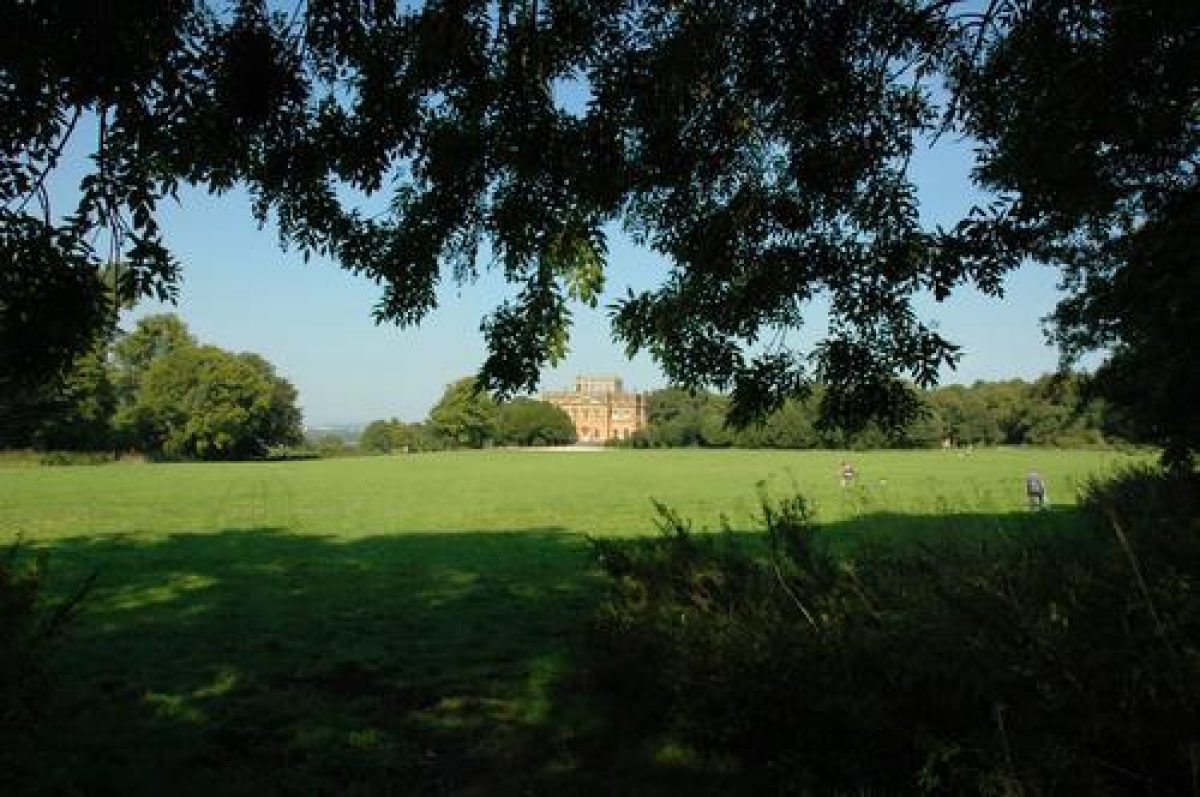
The park at Kings Weston occupies a favourable site on a narrow ridge of land, commanding extensive views over the Bristol Channel and the River Avon. Both the house and the park were laid out in the 18th century.
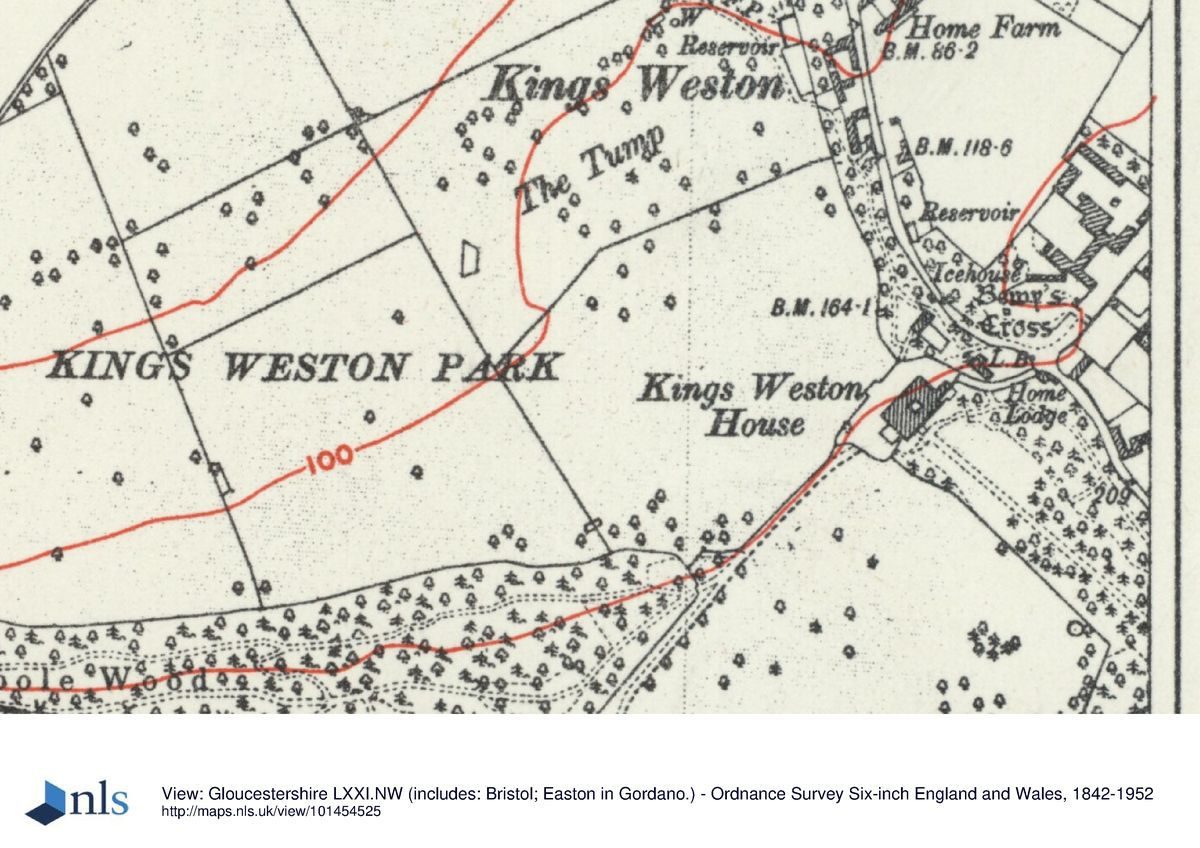
The entrance to Kings Weston House is by a former service drive from Kings Weston Lane which curves around the back of the House to reach its front on its south-western side. On the east side of the drive is the late-18th-century Home Lodge designed by Robert Mylne. There is a car park at the back of the house, as well as further car parking in a wooded area to the east of the drive.
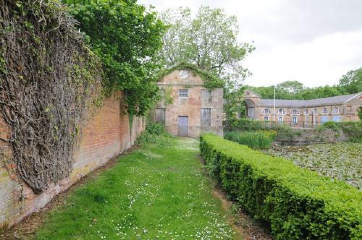
To the north of the house is a brewhouse, and a loggia behind which were the remains of an earlier banqueting house/laundry. Both of these early-18th-century buildings were designed by John Vanbrugh and have been converted into private houses.
Opposite Home Lodge is Napier Miles Road which leads past an icehouse in overgrown land on its west side to the mid-18th-century stable block designed by Robert Mylne.
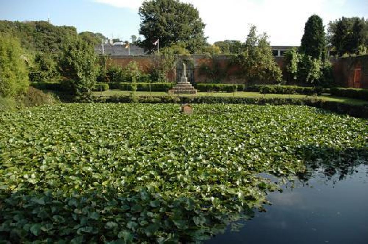
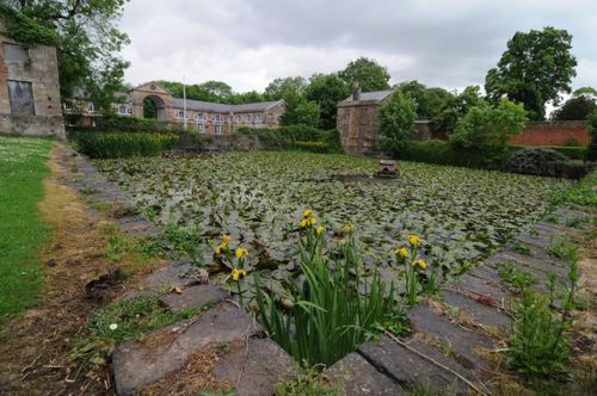
Opposite the stable block are two matching classical lodges, or gardeners' houses, and a central square pond set symmetrically within a walled garden. This composition was designed by Robert Mylne to echo the design of the stable block and is of the same date.
The former productive gardens were situated around this walled garden in further walled enclosures designed by Robert Mylne. Several of these (behind the garden with the pond) were used for the building of a dower house (which became known as The House In The Garden). This property is now used as a school and is outside the registered area of the park.
Napier Miles Road then leads north-east to the early-19th-century Henbury Lodge which marks the boundary with the Blaise Castle estate.
Echo Walk, a straight gravelled path, runs 300m uphill and south-east from the house to a former banqueting loggia known as the Echo, which was designed by John Vanbrugh and built about 1715. It is now roofless but stablilised.
To the either side of Echo Walk are woodlands containing some prominent 19th-century trees as well as 20th-century self-sown trees and scrub.
The area adjacent to the house on its south-east side has a lawn with marks of former planting beds either side of the Echo Walk for about 50 metres. The adjoining unmanaged woodland contains the bases and walls of uncompleted school buildings built just before World War 2.
A former carriage drive runs south-west from the front of the house through an informal double avenue of lime trees to meet a track (another former carriage drive) running east-west from The Echo to Penpole Point. The drive from the house continues on to reach Shirehampton Road.
The east-west track is an almost straight route of about 500 metres between narrow blocks of woodland and marks the southern boundary of the pleasure grounds.
Home Park Lawn, the roughly triangular area south of the house contained by Echo Walk and these two drives, is now a grassed open space.
The east-west track leads through an informal avenue of European limes dating from the 1700s westwards to Penpole Point which has wide views over the Bristol Channel and the River Avon. A viewing tower and breakfast lodge called Penpole Lodge was sited at the far end of the park at Penpole Gate about 1 km west of the House. The Lodge also served as an eyecatcher seen at the end of the tree-lined avenue from Kings Weston House, and was almost certainly designed by John Vanbrugh. It became a favoured destination for visitors to the park in the 18th century. Following vandalism which made it unsafe Penpole Lodge was demolished by Bristol Corporation in 1950.
A little to the west of the remains of the Lodge, on former common land, is a mid-17th-century compass. This was used by merchants to watch shipping movements on the River Severn and Avon. Ships would lie up in the safe anchorage of King Road, the gateway of the Port of Bristol, before attempting the difficult journey up the Avon to the quays in the city centre.
Penpole Wood runs along the ridge, and contains rows and a circle of lime trees of a similar age, mature and over-mature beech trees from the 1760s and indigenous and exotic planting, notably cedars, from 1870-90. This woodland is rather neglected and overgrown.
North-west and west of the house, overlooked by the terrace, is an area of woodland, formerly further terraces and gardens or orchards. This area is now somewhat overgrown with scrub.
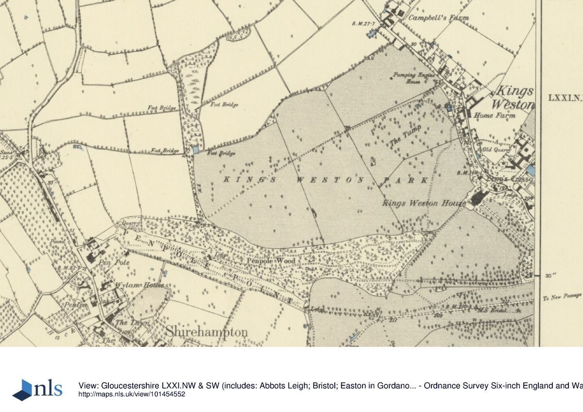
Some 300 metres further to the north-west is The Tump, an open grassy island of high ground with young trees on the summit and now separated from Kings West Park by housing. The Tump is a survivor of the pre-1771 landscape and was an important eyecatcher, aligned on an axial vista from the house and terrace.
Most of the open parkland of Kings Weston Park lies south of Shirehampton Road about 350 metres south of the house, and is now known as Shirehampton Park. The largest part of this is owned by the National Trust and is let as as a golf course to the Shirehampton Park Golf Club. This contains extensive areas of young trees and scrub, and earth moving has been carried out to create the golf course.
Shirehampton Park is separated from the Kings Weston estate by Shirehampton Road and a loose avenue of trees on the north side of the road. Edward Southwell was involved in the deformalisation of the estate between 1750 and his death in 1755, principally through the felling and planting of trees in spots partly advised by Norborne Berkeley of Stoke Park. Isaac Taylor's estate plan of 1772 shows an extensive informal landscape.
There are three lodges at the entrances to Shirehampton Park. The two Park Lodges, which controlled traffic on the Shirehampton Turnpike as it passed through the Park, were almost certainly built to designs by Robert Mylne. However, the east lodge at Park Gates was rebuilt, probably about 1840. The third lodge is Wood Lodge on Penpole Lane.
The park continues to the north-east of the house onto Kings Weston Hill. This has a path running over the top of open, but increasingly scrub-covered downland to the Blaise Castle estate, between the ornamental plantations of Evergreens Wood, Southside Wood and Limekiln Wood on the slopes. Meandering paths are laid out in Evergreens Wood and provide framed views to Kings Weston House and Blaise Castle. These woods were planted and the drives and walks developed under the ownership of the Miles family from the 1830s-1840s.
The house is now in private ownership and is used for corporate and private events (including conferences and weddings), with offices on the upper floors and a cafe in a vaulted semi-basement room.
The parkland surrounding the house and that stretching from Penpole Point in the west to Kings Weston Hill and the boundary with the Blaise Castle estate in the east is public open space owned by Bristol City Council. The parkland to the south of Shirehampton Road (known as Shirehampton Park) is, however, a private golf course with no access apart from public footpaths.
The following is from the Register of Parks and Gardens of Special Historic Interest. For the most up-to-date Register entry, please visit the The National Heritage List for England (NHLE):
www.historicengland.org.uk/listing/the-list
A mid to late C18 park, laid out with advice from Lancelot Brown, containing the remains of a formal layout dating from Sir John Vanbrugh's early C18 redevelopment of an earlier site.
DESCRIPTION
LOCATION, AREA, BOUNDARIES, LANDFORM, SETTING
The Kings Weston estate covers c 98ha and is located largely in the parish of Henbury, c 10km west of the centre of Bristol. It occupies a steep limestone spur which includes Kings Weston Hill and Penpole Point, commanding views over the Bristol Channel to the west and the Avon Gorge to the south and south-east. To the north-east the Kings Weston and Blaise Castle registered sites are contiguous and both are under the management of Bristol City Council. The historic boundary between the two shows that Evergreens Wood, Limekiln Wood, and Kings Weston Down to the north-east belonged to Kings Weston as well as land north to Henbury Lodge and east to Southside Wood as far as the rear of residences in the housing development to the east. The northern boundary is formed by fence lines and tracks. The eastern boundary is formed by the south side of Shirehampton Road and the rear of houses on the residential roads of the Sea Mills housing estate. The southern boundary is the edge of the Avon Gorge at the southern end of Shirehampton Park. The south-west boundary runs to the rear of buildings on Park Road and Park Hill, along a path between a public cricket ground and the playing fields of Shirehampton School, and extends westwards along Penpole Lane, on the edge of the wooded ridge to Penpole Point. The north-west boundary is defined by the rear of houses on Mancroft Avenue as far as Kings Weston Lane, the rear of the former stables in Napier Miles Road, and the rear of the properties in Lawrence Weston. Apart from the part-wooded and part-open country of Kings Weston Down to the north-east and the deeply incised Avon Gorge to the south the estate is on a relatively level plateau which falls away steeply to C20 housing developments to the north and west. To the east the land falls gently to the extensive C20 housing estates of Combe Dingle, Sea Mills, and Westbury-on-Trym.
Physically separated from the main estate but included in the land here registered is the Tump, a c 3ha open grassy island of high ground c 300m north-west of the House. The Tump is bounded to the north-west by a fence to school grounds and on the other three sides by the gardens of houses on Barrowhead Drive and Badenham Grove.
ENTRANCES AND APPROACHES
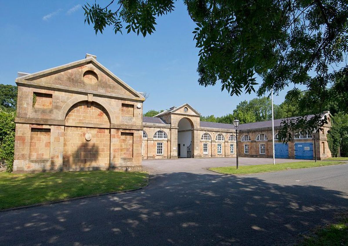
The entrance to Kings Weston House is via a 50m former service drive from Kings Weston Lane to the north-east, which enters a car park north-east of the rear elevation of the House. On the east side of this entrance is Home Lodge (Mylne late C18, listed grade II). The car park is enclosed 30m to the north and north-east by a range of garden and service buildings including The Loggia and remains of the Laundry (Vanbrugh c 1718, listed grade I), and the Brewhouse (Vanbrugh c 1715, listed grade I). A solitary gatepost (c 1760, listed grade II) stands 15m south of the Brewhouse and marks a former entrance to the House. Opposite and north-east of the Home Lodge entrance is Napier Miles Road which leads north-east past the Icehouse (C18, listed grade II) in a wooded bank 80m north of the House and the former Stable Block (1763, listed grade II*) c 180m to the north-east. On the opposite, south-east side of Napier Miles Road are the lodges, pond, and garden walls of the former kitchen garden (1763, listed grade II*) c 150m north-east of the House, now belonging to The House in the Garden. The road leads c 600m north-east to Henbury Lodge (c 1820-40), which marks the junction with the Blaise Castle estate (qv).
PRINCIPAL BUILDING
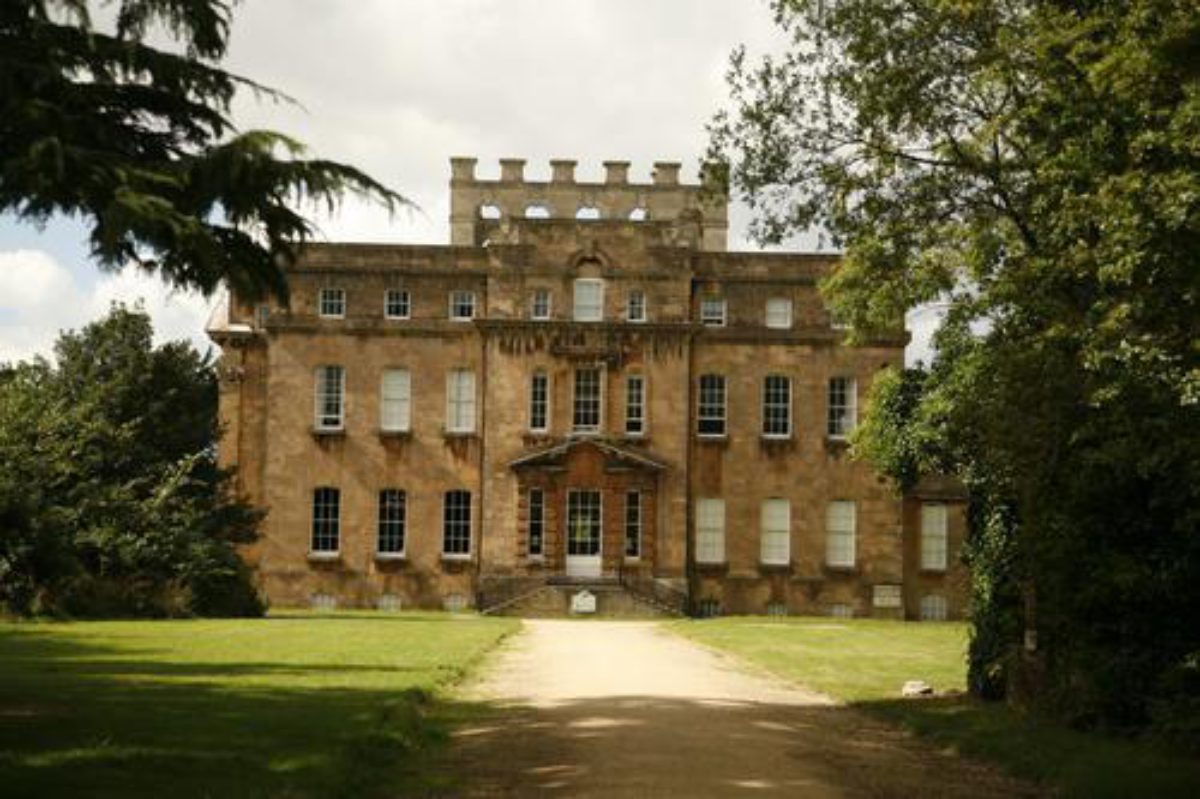
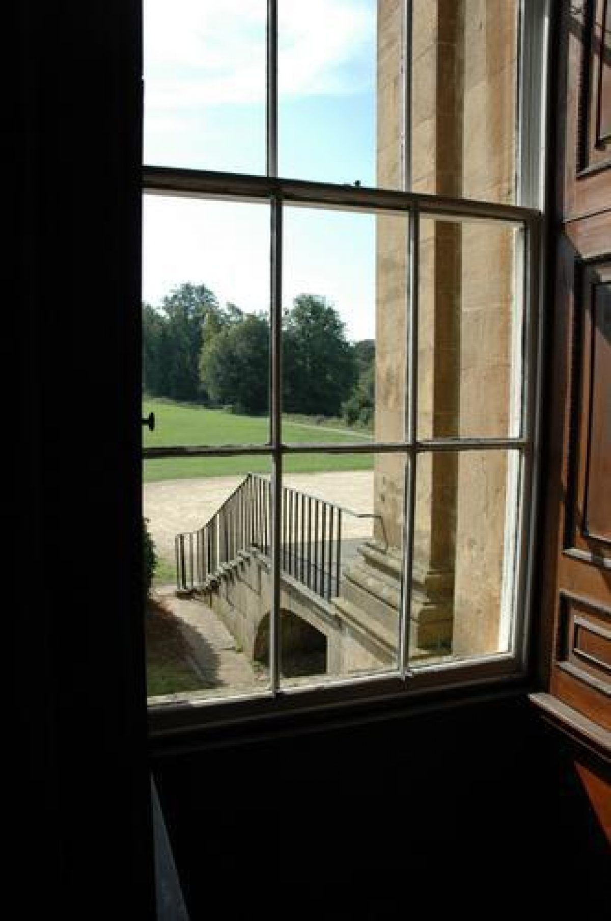
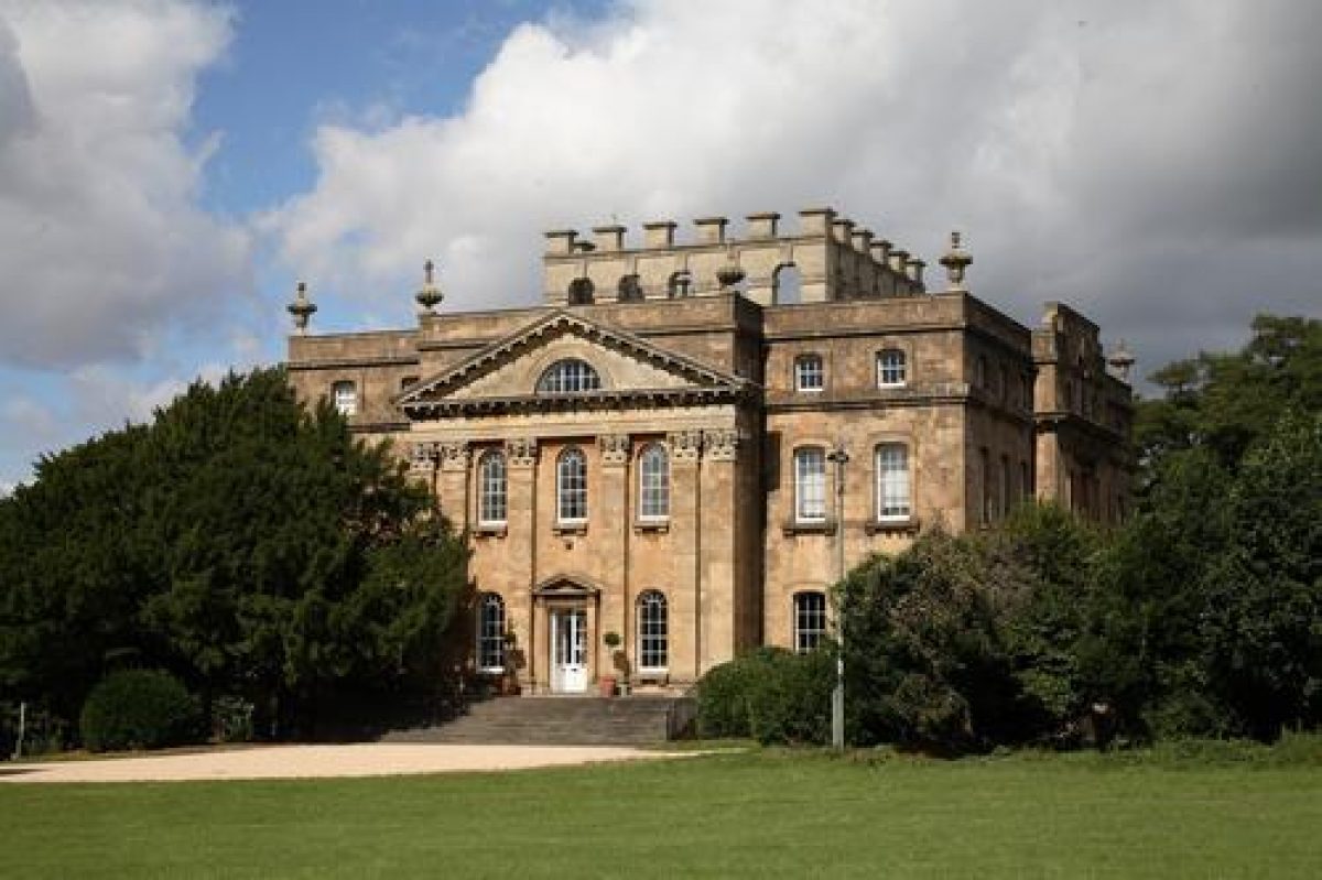
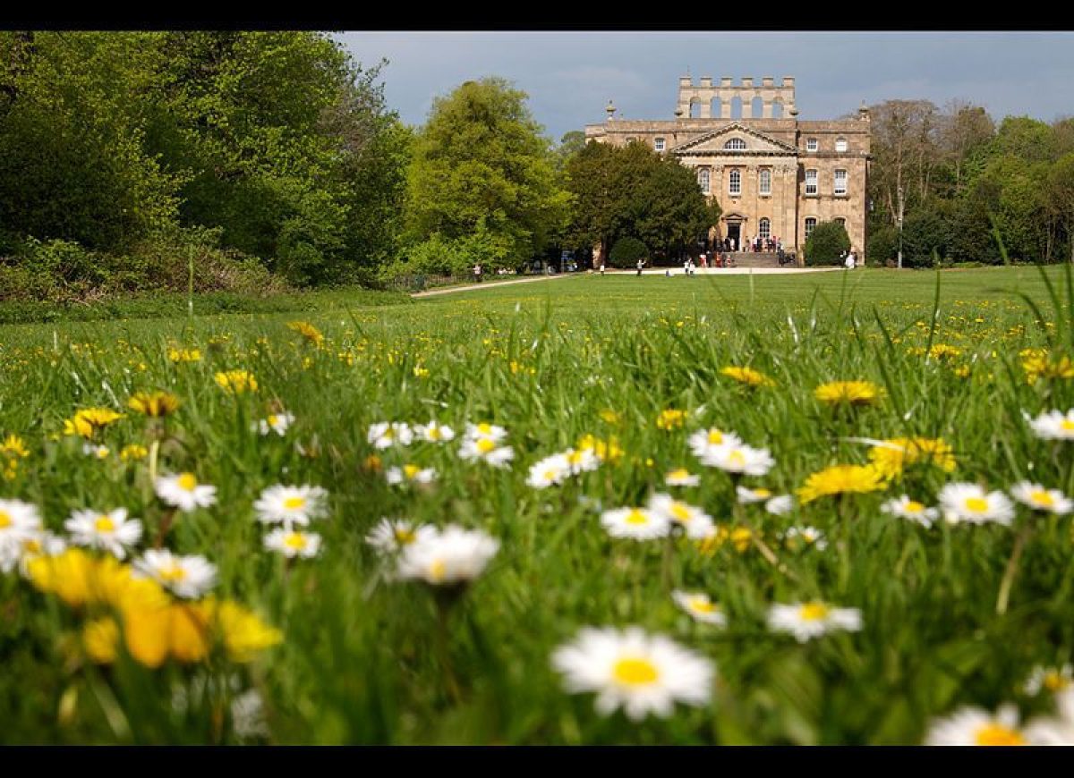
Kings Weston House (1710-25, listed grade I), designed by Vanbrugh, is located on the western edge of a south-west to north-east ridge and commands wide views over the Bristol Channel and the Welsh Hills. Foreground views have changed dramatically in the C20 with the development of the industrial complex at Avonmouth and the housing estate of Lawrence Weston. Work on the building started in 1714 following the demolition of the Elizabethan house and took more than a decade to complete. Vanbrugh was working on Castle Howard, Yorkshire (qv) and Blenheim, Oxfordshire (qv) at the same time as Kings Weston which was not finished by the time of his death in 1726. The severe Baroque style of the House and garden buildings may have been regarded as old-fashioned by the time it was completed as fashion had changed significantly in favour of the purely Palladian (Georgian Group Ann Rep 1985). Significant internal alterations were carried out by Robert Mylne (1764-75).
GARDENS AND PLEASURE GROUNDS
Some 30m north of the House, The Loggia terminates a terrace (late C19, replacing 1720s terrace, removed c 1770s) which runs c 100m south-west along the length of the north-west front of the House and continues for 300m through an informal double avenue of lime trees to meet a track running east/west from the Echo to Penpole Point. The terrace was formerly balustraded for most of its length, and some dressed stone remains in evidence on the ground. Lancelot Brown was paid £84 by Edward Southwell III for 'Alterations about the House and Terras' (Pearson Asocs 1994), work probably completed in the early 1770s and commented upon by Thomas Wright in 1776. North-west and west, extending c 70m below the House terrace, is an area of woodland, formerly further terraces and gardens or orchards.
Some 300m further to the north-west is The Tump, an open grassy island of high ground with young trees on the summit and now separated from Kings Weston Park by housing, which is included within the area here registered. The Tump is a survivor of the pre-1771 landscape and was an important eyecatcher, aligned on an axial vista from the House and terrace.
The east/west track, a former carriage drive c 250m south of the House, provides an almost straight route of c 500m between narrow blocks of woodland and describes the southern edge of the pleasure grounds. To the west the track leads 1km through an informal avenue of European limes (c 1700s) to Penpole Point which has views of the Bristol Channel. A viewing tower and breakfast lodge, after designs by Colen Campbell (1723) and Vanbrugh, at Penpole Gate, c 1km west of the House, was demolished by Bristol Corporation in 1952. Penpole Woods contain other rows and a circle of limes (c 1700s), mature and over-mature beech trees (c 1760s), and indigenous and exotic planting, notably cedars, from c 1870-90. In an easterly direction the track passes through woodland at the southern edge of Home Park Lawn and bends northwards for 100m to the Echo (Vanbrugh c 1715, listed grade I), a former banqueting loggia 300m south-east of the House, now roofless but stabilised, which faces north-west and is aligned to the south-east front of the House. A straight gravelled path of 300m, Echo Walk, runs uphill and south-east from the House to the Echo through woodland containing some prominent C19 trees and C20 self-sown trees and scrub. The area south-east of, and adjacent to the House has a lawn with marks of former planting beds either side of the Walk for c 50m. The unmanaged woodland contains the bases and some walls of the uncompleted school buildings. This area was laid out in the early C18 as elaborate parterres within walled garden enclosures, of which nothing visible remains. The roughly triangular area contained within the tracks south of the House, Home Park Lawn, is used as playing fields and maintained as amenity grassland (2002).
PARK
Most of the open parkland of Kings Weston Park lies south of Shirehampton Road, c 350m south of the House, and is now known as Shirehampton Park, the largest part of which is let by the National Trust to Shirehampton Golf Club. This contains extensive areas of young trees and scrub and earth-moving has been carried out to create the golf course. Shirehampton Park is separated from the Kings Weston estate by Shirehampton Road and a loose avenue of trees on the north side of the road. Memoranda show that Edward Southwell was involved in the deformalisation of the estate between 1750 and his death in 1755, principally through the felling and planting of trees in spots partly advised by Norborne Berkeley of Stoke Park, Avon (qv) (Pearson Assocs 1994). Robert Mylne continued to be employed at Kings Weston from 1763 until at least 1772, probably designing the classical Shirehampton Lodge 450m south-east of the House at the former entrance, now a public highway, to the then newly enlarged park. Isaac Taylor's estate plan of 1772 shows an extensive informal landscape. Kings Weston Hill, c 500m to the north-east of the House, has a path running over the top of open, but scrubbing-up, downland to the Blaise Castle estate between the ornamental plantations of Evergreens Wood, Southside Wood, and Limekiln Wood on the slopes. Meandering paths are laid out in Evergreens Wood and provide framed views to Kings Weston House and Blaise Castle. These woods were planted and the drives and walks developed under the ownership of the Miles family (c 1820-40s).
KITCHEN GARDEN
The former productive gardens, now part of a school named The House in the Garden, are located on the south-east side of Napier Miles Road, c 150m north-east of the House, opposite the former stables. Built in 1763 to designs by Robert Mylne, the garden is of symmetrical plan around a central square pond, surrounded by rubble and ashlar walls c 4m high. There are two matching classical lodges, or gardeners' houses, in the north and west corners of the walled garden. There are further walled enclosures on the same axis to the south-west and north-east, the latter containing glasshouses against the south-west-facing wall. The school, school grounds, and residences south-east of the walled garden are excluded from the site here registered.
REFERENCES
R Atkyns, The Ancient and Present State of Gloucestershire (1712)
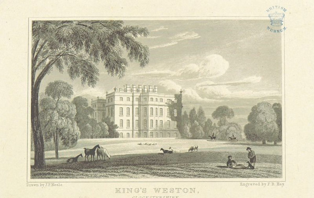
J P Neale, Views of the Seats... II, (1819)
Country Life, 6 (11 November 1899), pp 592-7; 61 (30 April 1927), pp 680-7; 113 (23 January 1953), pp 212-15
R Cooke, West Country Houses (1957)
N Pevsner, The Buildings of England: North Somerset and Bristol (1958, reprinted 1979), pp 469-70
Architectural History 10, (1967)
Georgian Group Annual Report (1985)
Avon Gardens Trust Newsletter 3, (1988)
N Kingsley, The Country Houses of Gloucestershire, Volume One, 1500-1660 (1989), pp 115-17
Kings Weston: Historic Landscape Survey & Management Plan, (Nicholas Pearson Associates 1994)
S Harding and D Lambert, Parks and Gardens of Avon (1994), pp 20-2, 41-2, 64
Maps
Kings Weston Estate map, 1720 (British Library) [reproduced in Pearson Assocs 1994]
Isaac Taylor, Kings Weston Estate map, 1772 [reproduced in Pearson Assocs 1994]
Isaac Taylor, Map of Gloucestershire, 1800 [reproduced in Pearson Assocs 1994]
Tithe map for Henbury parish, 1841 (Bristol Records Office) [reproduced in Pearson Assocs 1994]
OS 6" to 1 mile:
1st edition published 1887
1921 edition
Illustrations
J Kip, Kings Weston, the seat of Edward Southwell Esq (in Atkyns 1712)
Sir John Vanbrugh, Kings Weston House, 1713, in Kings Weston Book of Drawings (see Architect Hist 1967)
James Stewart, The front view of Edward Southwell Esq's Seat at Kings Weston, 1746 (Bodleian Library, Oxford Ms Gough Somerset 8, folio 36)
S H Grimm, Kings Weston Drawings, 1788 (Kaye Collection, British Library)
All the above and many more illustrations are reproduced in Nicholas Pearson Associates (1994)
Description written: November 2002
Register Inspector: SH
Edited: September 2003
- Visitor Access, Directions & Contacts
Telephone
07811666671Access contact details
The majority of the parkland is a public open space open at all times. However, the parkland south of Shirehampton Road (known as Shirehampton Park) is a private golf course. The house is used for private functions including weddings, corporate events, offices and as a cafe.
Owners
Bristol City Council
The Council House, College Green, Bristol, BS1 5TRThe National Trust
Heelis, Kemble Drive, Swindon, SN2 2NA
- History
The manor of Kingsweston was granted by Henry II to Robert Fitzharding, ancestor of the Berkeley family. It passed through various hands before being purchased in 1679 from Sir Humphrey Hook by Sir Robert Southwell. Southwell was a distinguished diplomat and later Secretary of State for Ireland.
Sir Robert spent the years from 1680 to 1690 in retreat at Kingsweston, working on the park and gardens, corresponding regularly with his friend John Evelyn. In a letter of January 8th, 1685, Sir Robert described to John Evelyn his new plantation of yews, hollies and firs.
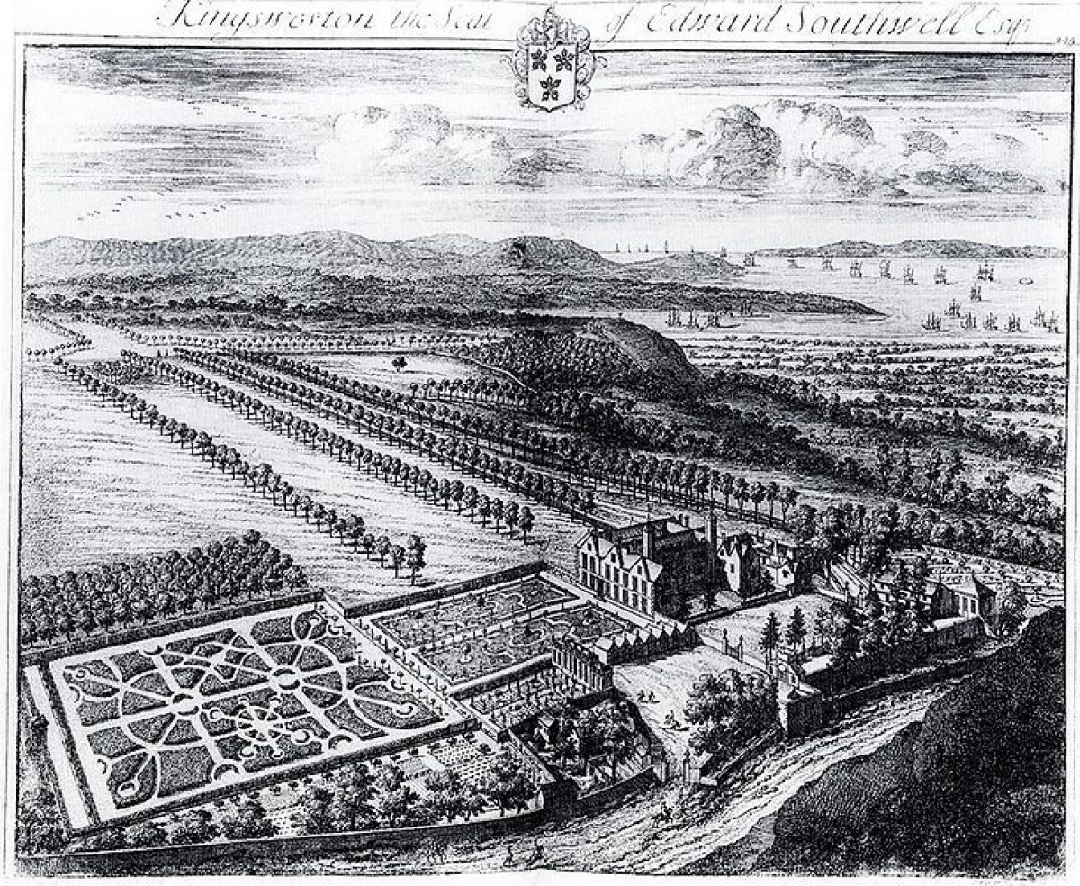
An engraving showing a bird's eye view of Kingsweston was published in Robert Atkyn's ‘Ancient and Present State of Gloucestershire' in 1712. This Kip engraving gives a clear idea of the state of Kingsweston before Edward Southwell started rebuilding in 1714.
The engraving shows a large Elizabethan mansion on the site of the present house. Geometrical formal gardens extend to the south-east of the house, terminated by a small gazebo or summerhouse. Long lines of regularly spaced trees run off to the south-west of the house, and towards Penpole Point. Various outbuildings and garden buildings are clearly shown.
Sir Robert Southwell died in 1702, leaving the estate to his son Edward. Edward Southwell also succeeded him as Secretary of State for Ireland, and became Clerk to the Privy Council in 1707.
He employed John Vanbrugh, then at the height of his fame, to design his new house and to help re-model the landscape at Kingsweston. It appears that Southwell and Vanbrugh saw the potential at Kingsweston for a Claudian landscape, complete with views of distant mountains and ships at sea, long before such landscape appreciation became general. Between them they created a landscape that came to be recognised as one of the finest in the country.
Vanbrugh designed a new house for Sir Edward in the severe Baroque style. This was built on the site of the old mansion between 1714 and 1725. An elaborate plan for a large balustraded forecourt was never realised, but several garden buildings were built at Kingsweston to Vanbrugh's design. Three of these survive (the Brewhouse, the Loggia and the Echo).
It is not clear exactly when the formal planting layout of the park and garden at Kingsweston was broken up. Inevitably, the construction of the new buildings from 1714 to 1725 must have necessitated the re-shaping of the park. A new phase of landscaping activity began in 1755 when Edward Southwell III began to alter his grandfather's estate.
He employed Robert Mylne to alter Vanbrugh's house and to design a stable block to the north-east of the mansion house on the far side of Kings Weston Lane. Mylne also laid out a square fishpond with flanking lodges to complement the stable block on the other side of the road.
Any remaining formal planting was taken up at this time, and a thick belt of trees was planted along the road. This was designed to give an Arcadian sense of isolation to the house and its grounds. The surveyor Isaac Taylor drew up a plan of the estate in 1771 which shows the house standing in an informally planted park of 125 hectares, and reveals what dramatic changes had taken place since 1710.
Capability Brown visited Kingsweston three times in 1777, and drew up plans for Edward Southwell of ‘general alterations, for the immediate surroundings of the house, and for the "terras"'. His bill was only £84, and it is probable that Brown only suggested superficial alterations to the well-established landscape at Kingsweston.
By this time, the fame of the landscape at Kingsweston had spread, and it was widely considered to be one of the finest in the country. Travellers to the West Country considered their trip incomplete without a visit to Kingsweston. Poems were written about the beauty of the place, and many drawings and paintings of the house and park were made. A visitor wrote in 1793 that ‘the infinite variety of verdure observable in different spots of this sublime landscape renders it one of the first in the kingdom'. At that time a gardener was employed at Kingsweston to conduct visitors around the grounds.
It was on account of Kingsweston enjoying popularity with fashionable visitors to Bath that Jane Austen referred it in her novels 'Northanger Abbey' and 'Emma' as being a destination to be enjoyed on an excursion by carriage.
The estate was held by the Southwells until 1833, when it was sold to Philip John Miles, owner of Leigh Court.
His son, Philip William Skynner Miles, headed a group of enterprising businessmen and helped finance The Bristol Port and Pier Railway Company which built a railway between Hotwells in Bristol and Avonmouth which opened in 1865. He also chaired the Bristol Port Channel Dock Company which built the Avonmouth Channel Dock. The Dock opened in 1877 and brought much prosperity both to the local area and to Bristol.
The last Squire of Kings Weston (as he was affectionately known) was his son Philip Napier Miles who succeeded to the estate in 1881. He was a gifted musican and a patron of music, and helped many struggling young musicians (including Marie Hall the leading violinist of her time) whom he invited to stay at Kings Weston House. The composer Ralph Vaughan Williams was one of his guests in 1920, and with the assistance of Marie Hall completed his work 'The Lark Ascending' for solo violin and piano whilst staying there. This work received its first public performance in December 1920 at the Shirehampton Public Hall played by Marie Hall, to whom it is dedicated.
In World War 1, due to the urgent need for hospital beds, Mr and Mrs Napier Miles converted their home into a hospital for wounded and convalescent servicemen. It was called the Bristol/10 King's Weston Auxiliary Hospital and was organised and controlled by Mr and Mrs Napier Miles. Mrs Miles served as a matron. A plaque above the front door of the House commemorates this time. '1915 -1919 To The Happy Memory Of The Wounded From Every Land Of The British Empire Who Were Gathered In This House In The Great War'.
Dr Napier Miles died in 1935, and the Kingsweston estate was sold at auctions in 1936 to pay for death duties. Parts of the estate had already been given away, however, including the 100 acres of the southern part of the park, known as Shirehampton Park, which had been donated to The National Trust in 1918. This land had been leased and used as a golf course by the Shirehampton Park Golf Club since 1906.
In October 1937 104 acres (43 hectares) of woodland and open spaces of Kings Weston Downs were bought by Bristol Corporation for £11,764.
Bristol Municipal Charities bought the house and 44 acres of its surrounding grounds for £9,800. It was their intention to move Queen Elizabeth's Hospital School from Berkeley Place in central Bristol to Kings Weston House. Alterations and additions were started including the removal of the 19th-century kitchens from the north side of the house and the erection of dormitories in the garden to the east. However, their plans were halted by the outbreak of war in 1939, and later abandoned. The remains of the dormitory buildings to first floor level still exist to the east of the house.
In 1937 a smaller house was built for Mrs Napier Miles in the kitchen gardens fronting Napier Miles Road (known as 'The House in the Garden'). However, this was requisitioned in the war and, following Mrs Napier Miles' death in 1948, was bought by Bristol Corporation for use as a school.
On 29th September 1939 the house and park were requisitioned by the War Office, Southern Command. The House was occupied partly by armed force units and partly by the Navy who planned there the various convoy movements to and from Avonmouth. Nissan huts were erected in the woodland to the south of the house for the Free Polish, as is evident from the concrete slabs, main drain and manhole covers which remain. Shirehampton Park was used as an U.S. Army Camp from 1942-1944 with huts erected on the golf course land adjoining Shirehampton Road for its entire length.
Following the War Bristol Municpal Charities leased the house to Bristol Education Committee for use as a primary school. Access to the parkland became unrestricted due to boundary fences falling into disrepair. Vandalism to one of Vanbrugh's buildings, Penpole Lodge on Penpole Point, was so bad that it became unsafe and was demolished by Bristol Corporation in 1950.
It seemed as though the house would suffer the same fate. However, in 1963 Bristol Municipal Charities sold the house and 38 acres of surrounding grounds to Bristol College of Science and Technology and a restoration of the house took place with public funds. The stable block was saved from demolition by a public outcry, and in 1962 was converted into a police station.
In 1970 Bristol Corporation, aided by a 50% grant from the Home Office, bought the house and its surrounding grounds for £305,000 to establish a Police Training School. The stable block was converted into police residential accommodation for use in association with the house. It is still used as police welfare offices.
Under Local Government reorganisation in 1974 the house and grounds became the property of the Avon and Somerset Police Authority. In 1978, following much local opposition, Bristol City Council refused planning permission for a new Avon and Somerset Police Headquarters in the grounds surrounding the house. Following this only basic maintenance was carried out to the house, and Vanbrugh's Brewhouse and Loggia/Laundry were becoming ruinous through neglect and vandalism.
Vanbrugh's banqueting house known as The Echo had been stabilised in 1974 as a shell lacking its roof. The Bristol Buildings Preservation Trust acquired and converted the Brewhouse to a private house following permission given in 1988, rebuilding its missing south-east wing. The Loggia/Laundry has also since been converted and extended to a private house.
In 1995 Avon and Somerset Police Authority ceased their use of the house which was then boarded up and at risk of deterioration. In order to secure the future of this important historic property Bristol City Council bought it in November 1995. In 2000 Bristol City Council sold the house, the Home Lodge and 5 acres of surrounding grounds on a long leasehold for use as a conference venue, business centre and for private and corporate events including weddings.
Following its renovation and its opening in 2001 Kings Weston House has been the venue for many successful events and celebrations. It has been used for filming and for photographic shoots, and has featured in both local and national media, including the 26th November 2008 edition of Country Life Magazine.
In 2012 Bristol City Council is producing the Kings Weston Historic Designed Landscape Review in consultation with other land-owners, interest groups and the local community. This Review will help to guide future proposals to restore and enhance the registered historic landscape and its buildings.
The following is from the Register of Parks and Gardens of Special Historic Interest. For the most up-to-date Register entry, please visit the The National Heritage List for England (NHLE):
www.historicengland.org.uk/listing/the-list
HISTORIC DEVELOPMENT
The manor of Kings Weston was so named as a detached western part of the king's ancient desmesnes of Berkeley Hundred (Neale 1819). It was recorded in Domesday and described by Atkyns (1712) as a 'considerable Manor' in the time of William the Conqueror. Henry VII granted the whole hundred of Berkeley to Robert Fitzhardinge, who subsequently settled the manor on his second son, Robert. The estate was inherited by William Berkeley who sold it in 1570 to Sir William Wintour, who probably built the Elizabethan house by 1588 (Kingsley 1989). It was later purchased by Sir Humphry Hook, whose son sold the property to Sir Robert Southwell (Cooke 1957). Southwell was a distinguished diplomat and politician, Secretary of State for Ireland and Clerk of the Privy Council, President of the Royal Society, and friend of John Evelyn (1620-1706), the C17 garden writer and author of the influential Sylva. He assisted in the arrangement of the marriage between William Blathwayt and Mary Wynter (1651-91), heiress to nearby Dyrham Park (qv), and his son married Blathwayt's daughter in 1716 (National Trust 1983). An extensive Anglo-Dutch garden was laid out at Dyrham with advice from George London (d 1714) and it is likely that this influenced the laying out of the landscape at Kings Weston (Pearson Assocs 1994).
Although there is no documentary evidence of the layout of the manor grounds during the Berkeley, Wintour, and Hook family tenures, it is probable that formal gardens would have adjoined the Elizabethan house, and that these gardens may have formed the basis of the extensive formal landscape laid out by Sir Robert Southwell during the late C17 and early C18, as recorded in Kip's prospect in Atkyns (1712). Sir Robert died c 1702 and the estate was inherited by his son Edward who, like his father, became Secretary of State for Ireland and Clerk of the Privy Council. In 1710, Edward Southwell, later Lord Clifford, commissioned Sir John Vanbrugh (1664-1726) to design a new house on the site of the old which was demolished in 1713-14. Despite the rich documentation of the architecture of the house and garden buildings there is little documentary evidence recording the early C18 landscape. It is possible that Vanbrugh contributed to this landscape, although there is no evidence of the involvement of a professional landscaper until Lancelot Brown (1716-83) was consulted in the period 1758-74. The park was considerably enlarged in the mid to late C18 by the addition of the 'new park' south of the current Shirehampton Road, known as Shirehampton Park. In 1763, Edward employed Robert Mylne (1733-1811) to complete the interior of the house and the outbuildings, including new designs for the stables, kitchen gardens, and lodges. The astronomer, architect, and landscape designer, Thomas Wright of Durham visited in 1774 while staying at Stoke Park, Avon (qv). The estate was let in 1822 and sold in 1833 to Philip Miles of Leigh Court, Avon (qv), becoming the residence of W Miles MP by 1844. A further phase of architectural and landscape development took place c 1820-40, including a new lodge at Henbury, the alteration of existing buildings, and the establishment of new plantations containing a large number of conifers. The estate declined in the C20 and in 1918, Shirehampton Park, the southern half of the parkland was given by Dr Napier Miles to the National Trust and let by the Trust for use as a golf course. On his death in 1937, the house was sold to Bristol Municipal Charities and 104 acres (c 43ha) of downland on Kings Weston Hill to Bristol Corporation. Work to develop a school at the house was halted by the Second World War, the site being occupied by troops instead. In 1948 the walled garden, pond, and lodges were bought by Bristol City Council which demolished Penpole Gate in 1952. The proposed demolition of the stables in 1959 was only rescinded following a press campaign. The house was restored with public funds in 1962-3. By 1970 a Police Training School was established at the house and the Brewhouse, Loggia and Laundry, and the Echo, a former banqueting loggia, were abandoned and under threat of demolition. Plans to redevelop Kings Weston as headquarters for the Avon & Somerset Police in the 1980s were halted due to public opposition, but the landscape continued to decline. The Echo was consolidated as roofless ruin c 1988 and the Brewhouse and Loggia were externally restored, the former being converted to provide three private dwellings by Bristol Buildings Preservation Trust in c 1990. Bristol City Council bought the house and grounds from Avon County Council c 1996. Kings Weston House is currently leased as a restaurant, café, and conference centre and the grounds are managed as public open space by the Council (2002).
- Associated People
- Features & Designations
Designations
Conservation Area
- Reference: Kingsweston and Trym Valley
The National Heritage List for England: Register of Parks and Gardens
- Reference: GD1279
- Grade: II
The National Heritage List for England: Listed Building
- Reference: Cross shaft beside pond opposite former Kings Weston stables
- Grade: II
The National Heritage List for England: Listed Building
- Reference: Gatepost approximately 20 metres north east of Kings Weston House
- Grade: II
The National Heritage List for England: Listed Building
- Reference: Henbury Lodge
- Grade: II
The National Heritage List for England: Listed Building
- Reference: Home Lodge and attached wall
- Grade: II
The National Heritage List for England: Listed Building
- Reference: Ice house approximately 50 metres west of former Kings Weston stables
- Grade: II
The National Heritage List for England: Listed Building
- Reference: Iron footbridge over Kings Weston Road
- Grade: II
The National Heritage List for England: Listed Building
- Reference: Kings Weston House
- Grade: I
The National Heritage List for England: Listed Building
- Reference: Loggia approximately 50 metres north of Kings Weston House
- Grade: I
The National Heritage List for England: Listed Building
- Reference: Milestone at ST 5418 7712 aproximately 400 metres west of Park Lodge
- Grade: II
The National Heritage List for England: Listed Building
- Reference: Park Lodge
- Grade: II
The National Heritage List for England: Listed Building
- Reference: Park Lodge, 1 Park Hill
- Grade: II
The National Heritage List for England: Listed Building
- Reference: Police station and attached walls to north east and south west, former Kings Weston stables
- Grade: II*
The National Heritage List for England: Listed Building
- Reference: Sundial at Penpole Point at ST 532 773
- Grade: II
The National Heritage List for England: Listed Building
- Reference: The Brewhouse, Kings Weston House
- Grade: I
The National Heritage List for England: Listed Building
- Reference: The Echo approximately 300 metres south east of Kings Weston House
- Grade: I
The National Heritage List for England: Listed Building
- Reference: Two gas lamps to south east of former Kings Weston stables
- Grade: II
The National Heritage List for England: Listed Building
- Reference: Two lodges and attached garden walls opposite former Kings Weston stables
- Grade: II*
The National Heritage List for England: Listed Building
- Reference: Wood Lodge
- Grade: II
The National Heritage List for England: Listed Building
- Reference: Shirehampton War Memorial - Grade II Listed in 2016
- Grade: II
Features
- Mansion House (featured building)
- Description: Kings Weston House is situated on the western edge of a limestone ridge, commanding wide views over the Bristol Channel and the Welsh Hills. It was designed around 1710 by John Vanbrugh for Sir Edward Southwell. Work on the building started in 1714 following the demolition of the Elizabethan house and took more than a decade to complete. Vanbrugh was working on Castle Howard and Blenheim at the same time as Kings Weston, and died in 1726. The house is in severe Baroque style, which may have been regarded as old-fashioned by the time it was completed as fashion had changed significantly in favour of the purely Palladian. It has two storeys, an attic and a basement, and is faced with limestone ashlar. The exterior is very much as Vanbrugh left it on two facades (the south-west and south-east facades). The south-west front elevation has an attached portico of six giant Corinthian columns, paired at the ends, and a lunette in the pediment. A flight of steps leads up to a small, central pedimented doorway and a two-leaf half-glazed door. Major alterations, probably by Mylne, took place to the other facades. The one notable external feature is on the roof where the chimneys are linked into an arcade forming three sides of a square. The interior was re-modelled by Robert Mylne from 1764 to 1775. The major part of the interior is taken up by two huge spaces: the two-storey entrance saloon which was re-designed by Mylne to accommodate 36 18th-century family portraits, and the three-storey stair hall which has a very fine hanging staircase dating from 1719. The house is now used as a conference and business centre and for private events including weddings, with offices on the upper floors and a cafe in a vaulted basement room.
- Earliest Date:
- Latest Date:
- Banqueting House
- Description: The banqueting house, known as the Echo, was designed by John Vanbrugh around 1715. It is located some 300 metres from the house at the far end of a walkway and enjoys a fine prospect of the south-east front of the house. It is made of limestone ashlar and rubble. Steps lead up to three raised semi-circular arches made with piers of heavily rusticated stone, with alternate vermiculated courses projecting, and large vermiculated keystones. In the back wall of the banqueting house are three niches, now empty. The building lacks its roof and was stabilised as a shell in 1974.
- Earliest Date:
- Latest Date:
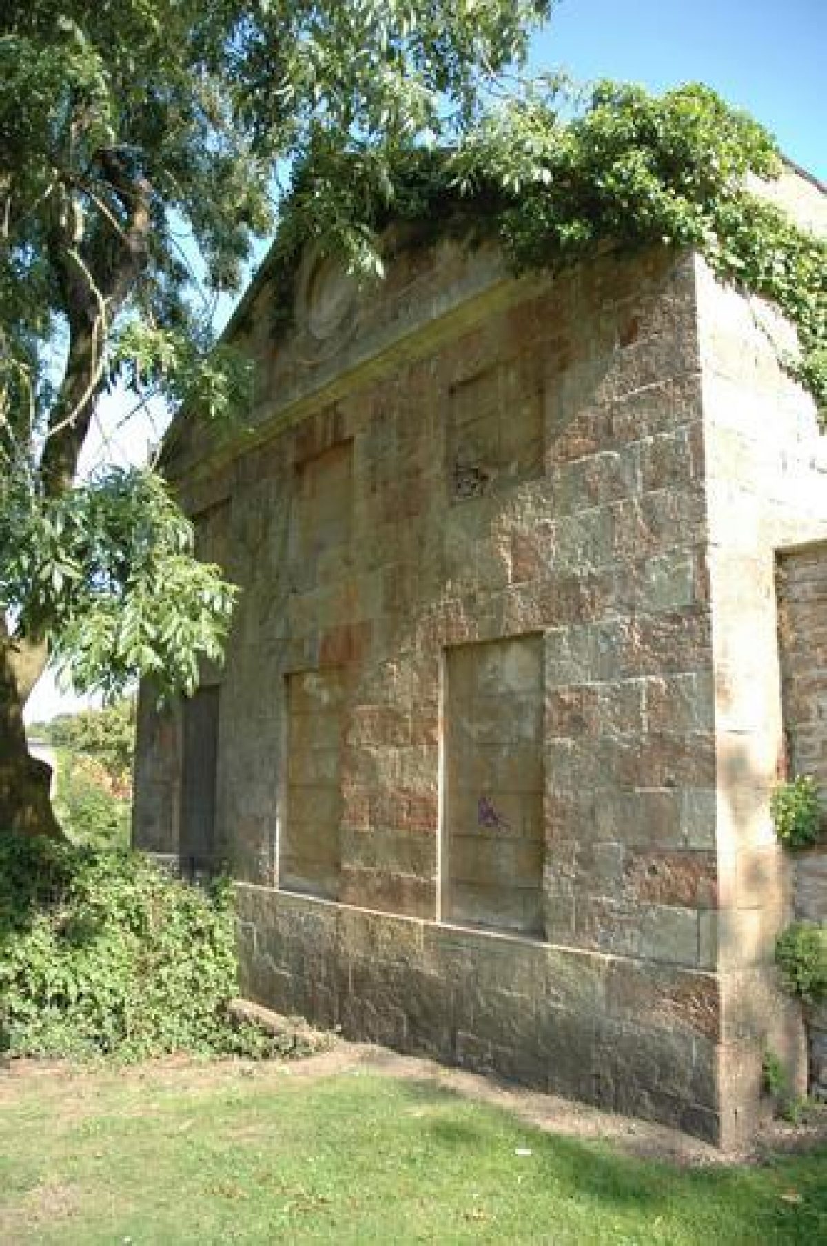
- Loggia
- Description: The Loggia was designed as a garden seat at the end of the terrace (which was built in the 1720s and removed in about the 1770s). It has a pedimented facade with a Venetian opening of paired Corinthian columns and is built with limestone ashlar, brick and limestone dressings. Attached at the rear were the very fragmentary remains of a pre-Vanbrugh, early-18th-century building used as banqueting house on the upper floor and probably a laundry on the lower floor. The Loggia and the remains of the earlier building have now been converted and extended to form a private house.
- Earliest Date:
- Latest Date:
- Garden Building
- Description: The Brewhouse was built around 1715 by John Vanbrugh. It has a three-unit ashlar front in simple form with segmental openings over the arched openings. The building was allowed to deteriorate resulting in the loss of its interior. Its south-east (right hand) wing was demolished. In 1991 it was externally restored and its south-east wing rebuilt to form a private house.
- Earliest Date:
- Latest Date:
- Icehouse
- Description: The icehouse was formerly on the west side of Kings Weston Lane, as shown on the 1772 Estate Map. It now stands in dense undergrowth on the eastern side of Kings Weston Lane. It is made of limestone rubble, and is domed in shape with a round-arched entrance.
- Earliest Date:
- Latest Date:
- Stable Block
- Description: The stable block is situated on Napier Miles Road opposite the lodges, pond and garden walls of the former kitchen garden which its design echoes. It was also designed by Robert Mylne and built in 1763. The stable block forms three sides of a quadrangle open to the road, with an archway in a pedimented gatehouse with a clock in the centre of the middle range. It is two storeys in height and finished with limestone ashlar and slates for the roof. Its interior was rebuilt when it became a police station which opened in 1962. It is now used as police staff offices.
- Earliest Date:
- Latest Date:
- Pool
- Description: The two lodges, pond and walled garden are on the south-east side of Napier Miles Road about 150 metres north-east of the house and opposite the former stable block. Built in 1763 to designs by Robert Mylne, the garden has a symmetrical plan around a central square pond, surrounded by rubble and ashlar walls some 4 metres high. The two matching classical lodges or gardeners' houses are in the north and west corners of the walled garden. They are square in plan, two storeys high, have pedimented facades facing the road and are finished with limestone ashlar and slates on the roofs. The pond originally provided fish, as well as ice for the ice house.
- Earliest Date:
- Latest Date:
- Kitchen Garden
- Description: The former productive gardens are located on the south-east side of Napier Miles Road about 150 metres north-east of the house, opposite the former stables. These were part of Robert Mylne's work and were complete by 1768. High rubble walls to these gardens extend along the road approximately 50 metres to the north-east and south-west of the two classically-designed lodges or gardeners' houses. Brick walls extend back from these high walls enclosing rectangular gardens. A house was built in 1937 for the widowed Mrs Sybil Miles in the gardens behind those next to the road, which became known as 'The House in the Garden'. Following the death of Mrs Miles in 1948 this property was bought by Bristol Corporation for use as a school, now called Kingsweston School. The school and its grounds are excluded from the area of the registered park and garden.
- Earliest Date:
- Latest Date:
- Gate Lodge
- Description: Home Lodge is situated on Kings Weston Lane on the east side of the entrance drive into Kings Weston House. It was designed by Robert Mylne and dates from the late-18th century. It is a two storey building finished with rubble with limestone ashlar dressings, roughcast, and pantiles for its roof. It has been unoccupied for many years.
- Earliest Date:
- Latest Date:
- Gate Lodge
- Description: Park Lodge is a late-18th century, toll-keeper's cottage at the 'Park Gates' entrance into the park from the direction of Bristol. It is situated on the north side of Shirehampton Road. Robert Mylne supplied designs for the two Park Lodges in 1767 and 1771, and both lodges were in existence by 1771, as the 1772 Estate Map shows. This lodge was rebuilt, however, in a slightly Italianate style in about 1840. It is a two storey cottage finished with stucco with limestone dressings and a pantile roof. It is recorded that the toll-gates were still in existence, if not in use, as late as 1916. Park Lodge is now a private house.
- Earliest Date:
- Latest Date:
- Garden House
- Description: Penpole Lodge was situated at Penpole Gate on the ridge of land known as Penpole Point at the end of a tree-lined avenue about 1 km west of the house, from which fine views over the Bristol Channel could be enjoyed. It was used as viewing tower, breakfast lodge and place of entertainment, and was also known as the 'Belvedere' and the 'Breakfast Room'. It also served as an eyecatcher to be viewed from Kings Weston House along the avenue. It was almost certainly designed by Vanbrugh. A dimensioned sketch drawing in Vanbrugh's hand survives at Elton Hall, Peterborough which coincides with the building erected. It had a central two storey gate tower and flanking single storey wings, with its front elevation facing east towards the house. Penpole Lodge became a favoured destination for visitors to the park in the 18th century. It remained in reasonable condition until World War 2 but decay and vandalism took its toll and by 1949 it was reduced to a roofless shell. As a result of its unsafe condition it was demolished by Bristol Corporation in 1950. Some remains are still visible, however, with parts of the south wing surviving to a height of over 4 metres.
- Earliest Date:
- Latest Date:
- Gate Lodge
- Description: Wood Lodge, Penpole Lane, is a late-18th- or early-19th-century toll-keeper's lodge at the Penpole entrance into the park. It was originally a rustic lodge, and possibly designed by Thomas Wright. It is single storey, faced with render and has a tiled roof. It is recorded that the toll-gates were still in existence, if not in use, as late as 1916. Wood Lodge is now a private house.
- Earliest Date:
- Latest Date:
- Terrace
- Description: When Vanbrugh redesigned the house, turning its main facade 180 degrees to face the park, he designed new terraces on its north-west side. These are shown on the 1720 Estate Map and in the Kingsweston Book of Drawings. The Loggia, in the form of a pedimented temple, was built as a focal point to terminate the terrace walk. By 1771 (the date of the survey of the 1772 Estate Map) these terraces had been removed with the introduction of an informal landscape. In the 19th century, following a revival in formal styles, a new terrace was built, as shown on the Ordnance Survey Map of 1880. It ran about 100 metres along the north-west side of the house, and continued for 300 metres through an informal double avenue of lime trees. The terrace was formerly balustraded for much of its length. This balustrade was erected in 1873, having been removed from Bristol Bridge during external alterations. It has now largely collapsed, and the terrace is decayed. The terraces have always commanded an impressive views to the north-west, looking over the Bristol Channel to South Wales.
- Earliest Date:
- Latest Date:
- Sculpture
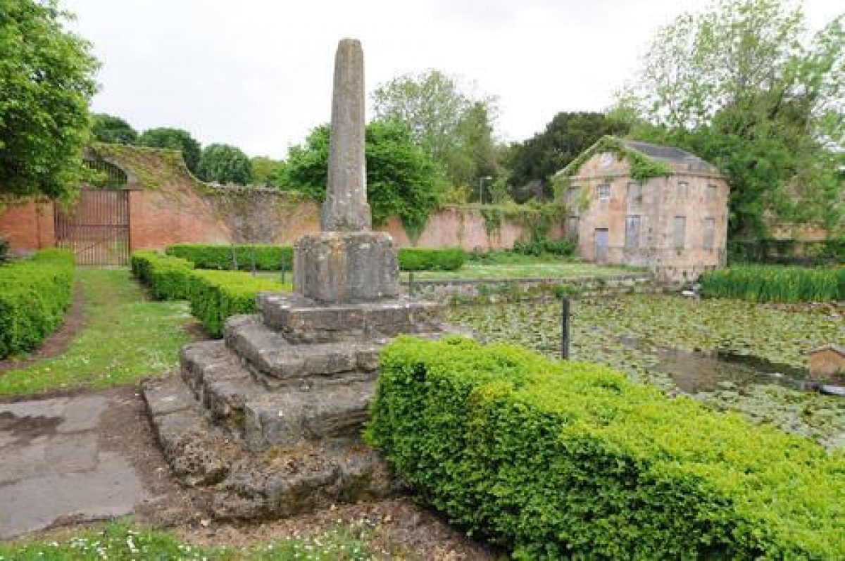
- Description: This feature is the Bewys Cross. It is considered to be of 14th/15th century date, and is made of limestone with a stepped square base. The cross no longer survives. It formerly stood in the Avonmouth area near the River Severn, and served as a sailors' cross. By the early-19th century it had been moved to the grounds of Kings Weston House to the south-west of the stable block on Napier Miles Road. It was again moved in 1954 by Bristol Corporation to the far side of the pond in the walled garden opposite the stable block.
- Earliest Date:
- Latest Date:
- Gate Lodge
- Description: Park Lodge, 1 Park Hill, is a late-18th century, toll-keeper's lodge at the entrance into the park from the direction of Shirehampton. It is situated on the south side of Shirehampton Road and has also been known as the Shirehampton Lodge. Robert Mylne supplied designs for the two Park Lodges in 1767 and 1771, and both lodges were in existence in 1771, as the 1772 Estate Map shows. It is a single storey cottage with a timber, tetrastyle Doric portico with an oculus in the pediment facing the road, and is finished with rough cast and with slates and tiles for the roofs. It is recorded that the toll-gates were in existence, if not in use, as late as 1916. Park Lodge is now a private house.
- Earliest Date:
- Latest Date:
- Gate Lodge
- Description: Henbury Lodge is situated on Kings Weston Road at the entrance into the park along Napier Miles Road. It marks the junction of the Kings Weston estate with the Blaise Castle estate. It is an early-19th-century cottage, two storeys in height, faced with render and with a pantiled roof. Henbury Lodge is now a private house.
- Earliest Date:
- Latest Date:
- Ornamental Bridge
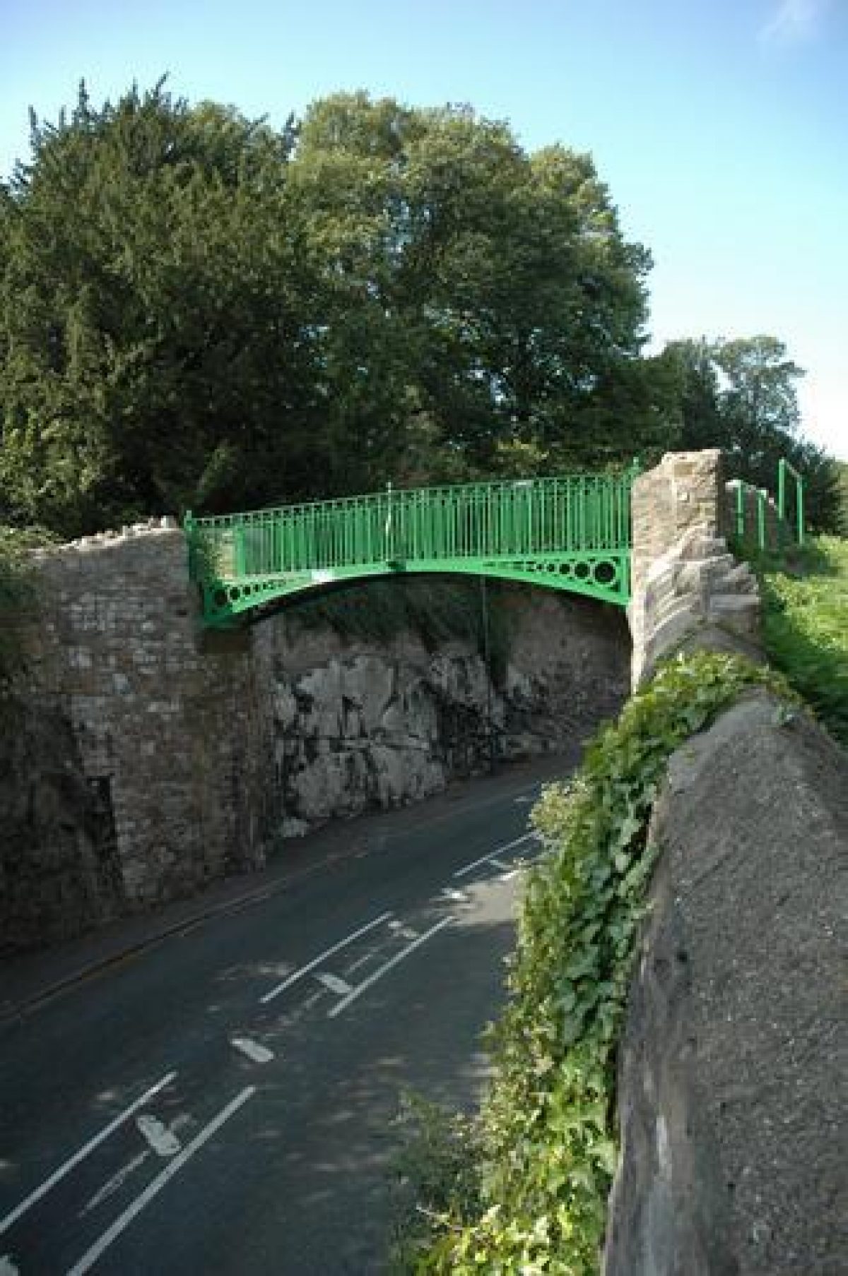
- Description: The footbridge, known locally as the 'Iron Bridge', is early-19th century in date and was built when Kings Weston Road was cut through the hillside replacing the narrow lane to the east which passed in front of the Kingsweston Inn. The footbridge spans Kings Weston Road and connects the Shirehampton Park and Kingsweston Downs parts of the park. It is made of cast-iron and pennant stone, and has a segmental arch with circular-pierced spandrels and urn finials.
- Earliest Date:
- Latest Date:
- Garden Ornament
- Description: This feature is a compass which is situated on Penpole Point overlooking the Bristol Channel and the mouth of the River Avon. It is on former common ground to the west of the remains of Penpole Lodge (the viewing tower and breakfast room which was demolished in 1950). The simple mouldings of the capstone are consistent with the compass being of mid-17th century date. In 1668 the Merchant Venturers Society voted Sir Humphrey Hook #5 towards repairing "the compasse upon Pen Pole Hill; the rest to be made good at his charge". It is octagonal in plan, 2 metres high and is made of three blocks of dressed limestone. The capstone has radiating raised ribs marking the points of the compass, and the remains of two sundials on its east and west faces. A mid-19th century cast-iron seat encircles the base and which replaced an earlier wooden seat.
- Earliest Date:
- Latest Date:
- War Memorial
- Description: The Shirehampton War Memorial was built on parkland donated by Philip Napier Miles at the corner of Shirehampton Road and Penpole Lane. It takes the form of a cross of York stone with a finial and commemorates the 58 local men who gave their lives in the 1914-1918 War. It was dedicated by the Archdeacon of Bristol and unveiled by General C.E.Bruce C.M.G.,D.S.O. on 4th September 1921. General Bruce had known Shirehampton since boyhood and had been a patient at the Kings Weston Auxiliary Hospital. Shirehampton War Memorial was grade II listed in 2016.
- Earliest Date:
- Latest Date:
- House
- Parkland
- Golf Course
- Office
- Key Information
Type
Park
Purpose
Ornamental
Principal Building
Commercial
Survival
Extant
Hectares
98
Open to the public
Yes
- References
References
- Harding, S and Lambert, D. {Parks and Gardens of Avon} (1994), pp 20-2, 41-2, 64 Parks and Gardens of Avon
- Atkyns, Robert {The Ancient and Present State of Gloucestershire} (London: W. Bowyer for Robert Gosling, 1712) The Ancient and Present State of Gloucestershire
- List of Buildings of Special Architectural Interest, City of Bristol, Avon
- Robert Southwell {Southwell Papers} Southwell Papers
- {Estate Survey of Kingsweston} (1771) Estate Survey of Kingsweston
- Ibbetson, Julius {A picturesque guide to Bath, Bristol, Hot Wells, the River Avon, and the adjacent country} (London, 1793) A picturesque guide to Bath, Bristol, Hot Wells, the River Avon, and the adjacent country
- Gomme, Andor Harvey {Bristol : an architectural history} (London: Lund Humphries, 1979) Bristol : an architectural history
- Phillips, Thomas {A list of pictures at Kingsweston, taken July 1695} (1695) A list of pictures at Kingsweston, taken July 1695
- {Estate map of Kingsweston} (1720) Estate map of Kingsweston
- Mowl, T. {The Kingsweston Garden Buildings} (1984) The Kingsweston Garden Buildings
- Austen, Jane {Northanger Abbey} (1803) Northanger Abbey
- Pevsner, N. {The Buildings of England: North Somerset and Bristol} (Harmondsworth: Penguin, 1958) The Buildings of England: North Somerset and Bristol
- {English Heritage Register of Parks and Gardens of Special Historic Interest } (Swindon: English Heritage 2008) [on CD-ROM] Historic England Register of Parks and Gardens of Special Historic Interest
- Stroud, Dorothy {Capability Brown} (Country Life, 1950) Capability Brown
- Russell. J {'The Lodge and Compass on Penpole Hill'} (Avon Gardens Trust, 2004) 'The Lodge and Compass on Penpole Hill'
- Thomas E. {Shirehampton Story} (1993) Shirehampton Story
- Fisher J. and D. {Shirehampton Sea Mills On Old Postcards} (1994) Shirehampton Sea Mills On Old Postcards
- Nicholas Pearson Associates {Kings Weston Historic Landscape Survey} Kings Weston Historic Landscape Survey
Contributors
E.T. Thacker
Avon Gardens Trust
Ruth Corner