Introduction
Lincoln's Inn Fields form a public park of about 5 hectares, and include lawns, trees, public tennis courts and a bandstand. The present layout dates from the early-19th century, and has not changed significantly since.
Terrain
The square is on a very slight slope from north-west to south-east.The following is from the Register of Parks and Gardens of Special Historic Interest. For the most up-to-date Register entry, please visit The National Heritage List for England (NHLE):
Location, Area, Boundaries, Landform and Setting
C17 public square, developed in the C18 and C19.
Lincoln's Inn Fields, c 4ha, is located to the east of Kingsway and south of Holborn, within the Holborn district of the London Borough of Camden. The gardens are surrounded by Lincoln's Inn to the east and the buildings within the square to the north, west and south. The square is enclosed by steel railings (which replaced the original cast-iron railings removed during the Second World War) and is on a very slight slope from north-west to south-east.
Entrances and Approaches
There are seven entrances to the gardens, one in the centre of each side and one in each corner, except the south-west. These are through gates in the cast-iron railings. Immediately outside the north-west and south-east entrances are drinking fountains, the fountain to the south-east, c 1880, commemorating Philip Twells MP (listed grade II).
Gardens and Pleasure Grounds
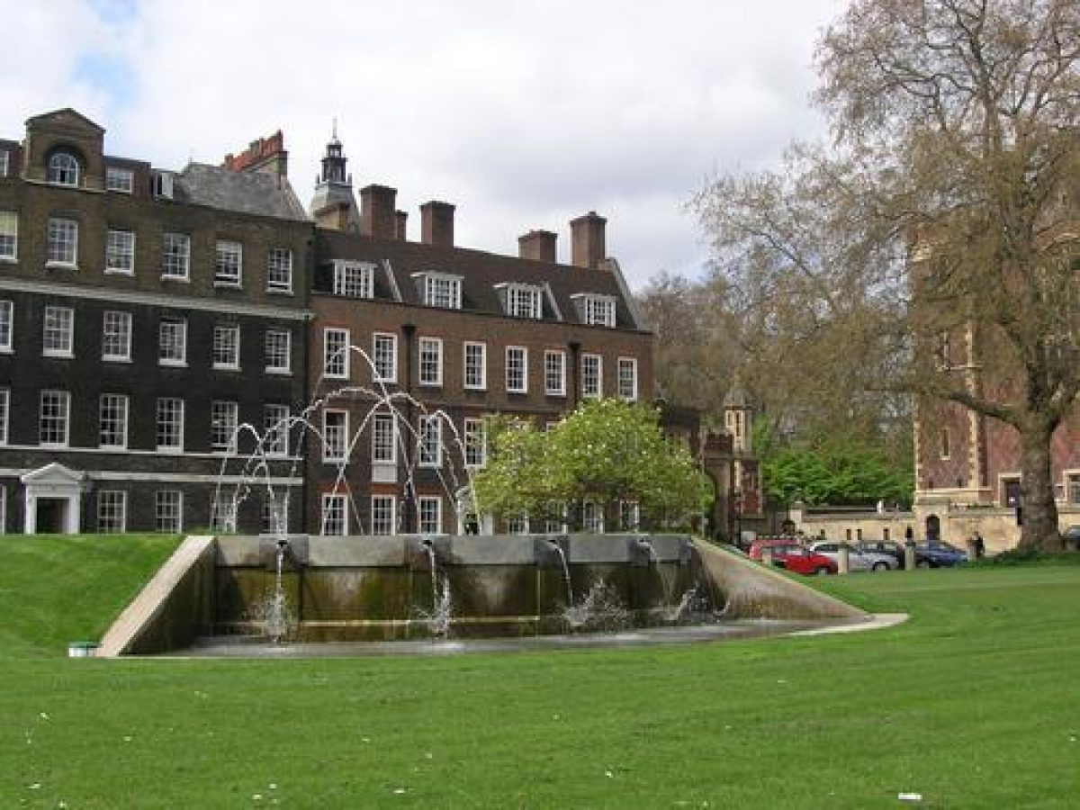
The gardens are laid out on a cruciform plan with a perimeter shrubbery and path. The western shrubbery has areas of bedding set into it. The cross paths meet at a large, lozenge-shaped area in the centre of the gardens, with an octagonal pavilion. The quarters to the north-west, north-east and south-east are surrounded by heavy modern fencing. The two northern quarters are open lawns with scattered mature trees. The quarter to the south-west is mostly taken up by tennis courts and a café (demolished and being replaced in 1998), with an area of bedding to the north of them. The south-east quarter is lawn with scattered trees, with an area of sub-tropical planting on the east side. The mature trees include Indian Bean trees and very large planes. Other trees include ginkgo, holly, mountain ash, prunus, and laburnum.
Along the northern perimeter walk are various features including the Canada Walk (commemorating the Canadians who died in the Second World War); a memorial seat to Mrs Ramsay MacDonald (c 1911, listed grade II), which consists of a granite alcove seat surmounted by a bronze group (depicting Mrs Ramsay with a group of nine children) by the sculptor R R Goulden; and in the north-east corner a Portland stone pedestal seat to W H Smith, second Viscount Hambledon (1869-1928), (c 1929, listed grade II), originally with bronze bust, missing late C20.
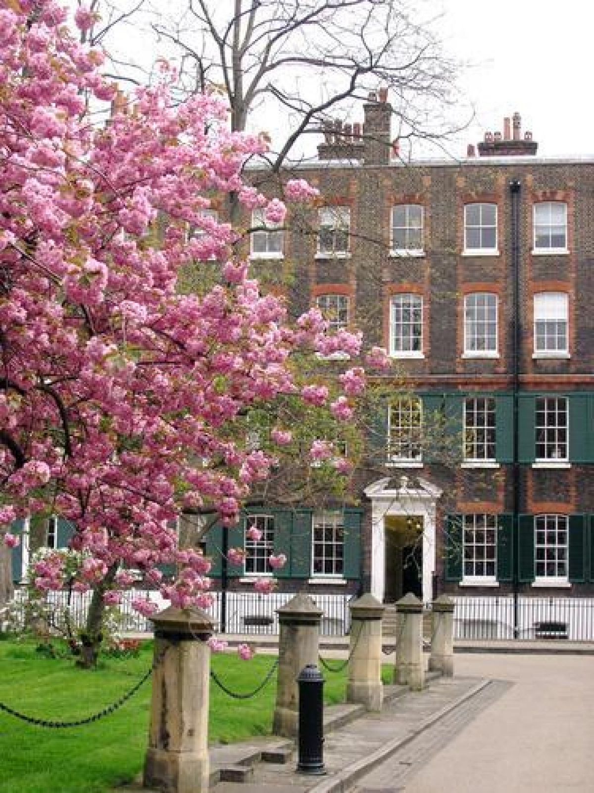
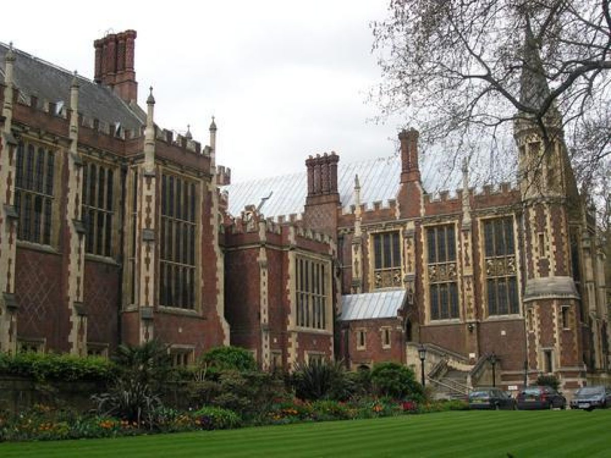
There are views out of the gardens to the surrounding buildings, which include to the north: C18 houses (Nos.1, 2, 5, 6-8, 15, 16, 25(27, all listed grade II), the Soane Museum (Nos.12-14, listed grade I), and some C19 houses (Nos.18, 19, 24, all listed grade II). The buildings on the south side include the Royal College of Surgeons and those on the west side include some C18 houses (Nos.57-58, 65, listed grade II*), an early C19 house (No.64, listed grade II), and some C17 houses (Nos.59-60, listed grade I, and No.66, restored by Lutyens in 1930 (listed grade II* with No.65)). To the east are Lincoln's Inn Hall (listed grade II*), Library (listed grade II*) and gardens.
Maps
- Richard Newcourt, Exact Delineation ... of London, 14" to 1 mile, 1658
- Morden and Lea, Map of London, 1682
- Stow, Map of London (published in Survey of London, 1720 edn)
- John Rocque, Plan of the Cities of London and Westminster ..., 1744-6
- Cary, Plan of London, 1787 Richard Horwood, Plan of the Cities of London and Westminster, 2nd edn 1813
- OS 25" to 1 mile:
- 1st edition surveyed 1873
- 2nd edition published 1894
- 3rd edition published 1914
Description written: August 1998
Amended: March 2000
Register Inspector: CB
Edited: May 2000, February 2022
- Visitor Access, Directions & Contacts
Access contact details
This is a public square, which is open daily until dusk.
There are 3 hard tennis courts - can be used for netball, no floodlights
fields Bar and Kitchen
nearby public toiletsDirections
Tube: Chancery Lane (Central), Holborn (Central, Piccadilly). Bus: 1, 8, 25, 59, 68, 91, 168, 171, 188, 242, 243.
Owners
London Borough of Camden
- History
The following is from the Register of Parks and Gardens of Special Historic Interest. For the most up-to-date Register entry, please visit The National Heritage List for England (NHLE):
17th Century
Lincoln's Inn Fields was originally known as Fickett's Field, which was in 1657 divided into two fields; the dividing line ran approximately from the Soane Museum to the Royal College of Surgeons. Described in the C17 as a 'wild-looking place of evil repute, and the scene of bloody execution' (quoted in Taylor 1953), it was the site of the execution of Lord William Russell in 1683, for his part in the Rye House Plot. John Gay recorded the dangers of the Fields in Trivia (1716). A Royal Commission was set up in 1618, with Inigo Jones, the Surveyor General, as one of the Commissioners. The Commissioners proposed a survey of the fields and Jones was asked to draw up a plan for walks in the fields and plans for surrounding houses. Nothing came of it.
Between 1629 and 1638 William Newton acquired control of the fields and began to build houses to the west (known as Arch Row) and south (Portugal Row). By 1658(9 houses had been built along the north (Newman's Row), south and west sides, the east side being the property of Lincoln's Inn.
After 1657 the land on the west side was known as Pursefield and that to the east as Cupfield. In the C16 Lincoln's Inn gardens (formerly the gardens of the Earl of Lincoln) were separated from Fickett's Field by a clay embankment, later replaced by a brick wall. Parts of Lincoln's Inn Fields (the area of Cupfield to the east) were laid out with walks c 1659. Morden and Lea's map of 1682 shows diagonal paths crossing the whole rectangular area comprising Pursefield and Cupfield.
18th - 19th Century
By the early C18 'the great Square, now called Lincoln's Inn Fields ... hath for some Years past lain waste and in great Disorder, whereby the same has become a receptacle for Rubbish, Dirt and Nastiness of all sorts ... but also for Want of proper Fences to enclose the same great Mischiefs have happened' (from the preamble to the Act 8 Geo II cap XXVI, 1735).
A Bill in 1707 to enhance the Fields had failed but in 1735 a formal layout of grass and gravel walks was authorised. The Fields were enclosed with an iron palisade on a stone plinth and in the centre there was a large basin of water. This layout is shown in Rocque's plan of 1746. The basin was a source of some contention and in 1790 it was filled in.
The gardens were closed to the public from 1735 until 1894, when the London County Council obtained possession of the gardens and they were opened to the public. The present layout dates from the early C19, and has not changed significantly since. This consists of perimeter shrubbery and path, with areas of bedding, and cruciform paths across the garden with an octagonal pavilion in the centre. There are scattered mature trees throughout with sub-tropical planting on the east side. Trees include Catalpa, ginkgo, holly, mountain ash, prunus, laburnum and mature plane trees.
In the north-east side of gardens is a memorial to W F D Smith, 2nd Viscount Hambleden, on a pedestal c1929-30. The monument, a Portland stone pedestal in the form of a seat, was designed by Sir Edwin Lutyens, with a bronze bust by Arthur Walker now missing (stolen 1970s). It is inscribed with Viscount Hambleden's biography; at the rear is a carved coat of arms in a central panel. In the north-west corner of the gardens is a stone drinking fountain of 1861, restored c1992, which is inscribed "The Fear of the Lord is a Fountain of Life". The name of the donor is unknown but a letter read out to an 1860 meeting of the District Board of Works states that "A lady residing in the neighbourhood of London is anxious to be permitted to put up a Drinking Fountain at her own expense in this Parish and prefers to place it in Lincoln's Inn Fields". This is an early public drinking fountain erected at the time when the St Giles's parish wells were polluted with sewage and the Board of Works were realising the need to provide pure public water: Lincoln's Inn Fields was being restored and renovated at the time.
In the south-east corner is the granite drinking fountain of c.1880 commemorating Philip Twells MP. Also in the garden is a monument in the form of a curved alcove with seat surmounted by a bronze group erected in c.1911 to commemorate Margaret MacDonald, the wife of Ramsey MacDonald, social reformer. Executed by the sculptor R R Goulden, it has a portrait figure of Mrs MacDonald seated with arms outstretched wearing Classical robes flanked by a group of 9 playing children. Inscription carved beneath statue reads: "This seat placed here in memory of Margaret MacDonald who spent her life in helping others".
The C19th cast-iron railings that enclosed the gardens were removed in WWII for the war effort and since replaced. During the war the gardens were used by the Royal Canadian Air Force, which was commemorated in 1998 by Canada Walk and planting of a Canadian Maple. Recent renovations include a new café; an oak tree was planted in 2000 for the bicentenary of the Royal College of Surgeons. Just outside the north corner is a sculpture by Barry Flanagan of 1980, 'Camdonian'.
21st Century
Lincoln's Inn Fields are now managed by Camden Borough Council
- Associated People
- Features & Designations
Designations
Conservation Area
- Reference: Bloomsbury
The National Heritage List for England: Register of Parks and Gardens
- Reference: GD1813
- Grade: II
Site of Local Importance for Nature Conservation
Features
- Bandstand
- Lawn
- Water Feature
- Railings
- Description: The square is enclosed by steel railings (which replaced the original cast-iron railings removed during the Second World War).
- Recreation ground
- Description: Public tennis courts
- House
- Description: Gardens are surrounded by Lincoln's Inn
- Railings
- Description: The square is enclosed by steel railings
- Entrance
- Description: There are seven entrances to the garden
- Path, Shrubbery
- Description: A perimeter shrubbery and path
- Trees
- Description: The mature trees include Indian Bean trees
- Walk, Perimeter
- Description: Northern perimeter walk
- Walk
- Description: Canada Walk
- Memorial
- Description: Memorial seat to Mrs Ramsay MacDonald
- Key Information
Type
Designed Urban Space
Purpose
Recreational/sport
Principal Building
Parks, Gardens And Urban Spaces
Survival
Extant
Hectares
4.8
Open to the public
Yes
- References
References
- {English Heritage Register of Parks and Gardens of Special Historic Interest} (Swindon: English Heritage 2008) [on CD-ROM] Historic England Register of Parks and Gardens of Special Historic Interest
- Cherry, B. and Pevsner, N. {The Buildings of England: London 4: North} (London: Penguin, 1998) pp 306-309 The Buildings of England: London 4: North
- {Lincoln's Inn Fields Conservation Management Plan} (2008) Lincoln's Inn Fields Conservation Management Plan
- (1895), pp 261-2 Gardeners' Chronicle I
- Sexby, J, J., (1905), pp 487-510 The Municipal Parks, Gardens, and Open Spaces of London
- Cecil, E, B., (1907), pp 234-6 London Parks and Gardens
- London County Council, (1912), pp 3-22, pls 1-8 Survey of London III
- Taylor, G., (1953), pp 26-8 Old London Gardens