Introduction
The park was landscaped in the late-18th century on an earlier site, and was further developed in the 19th century. A public park since 1925, the site occupies 71 hectares and includes a large ornamental lake. A number of earlier landscape features remain, including the Potomac Pond with Pulhamite rock work; Princess Amelia's Bath House, Japanese Garden and Italian Garden.
Terrain
Sloping from north to south.www.historicengland.org.uk/listing/the-list
An 18th century formal garden, altered in the mid 18th century with some involvement from William Kent. The grounds were developed in the later 18th century for Princess Amelia and extended in the mid 19th century by Baron Lionel de Rothschild. The site became a public park in 1925.
DESCRIPTION
LOCATION, AREA, BOUNDARIES, LANDFORM, SETTING
Gunnersbury Park is situated in the suburbs of West London, c 1km south of Acton. Chiswick House (qv) is c 2km to the south-east, and Syon Park (qv) c 2km to the south-west. Walpole Park (qv), Ealing is c 2km to the north. The 75ha site is bounded to the north by the backs of houses on the south side of Pope's Lane (B4491). Pope's Lane provides the boundary to the north-east corner, and Gunnersbury Avenue (A406 North Circular) the boundary to the east. The southern boundary is made up of to the west, a belt of factories, and to the east Kensington Cemetery. A local road, Lionel Road, provides the southern half of the west boundary with the backs of houses in the same road forming the boundary to the north-west. The site slopes down generally from north to south.
ENTRANCES AND APPROACHES
The main entrance is through the north gateway (listed grade II) on Pope's Lane. The impressive early C19 iron gates are hung from four tall stucco piers with entablatures and original lamps. Inside the gates to the east is the North Lodge (listed grade II). Sidney Smirke added a Doric portico to the Lodge c 1835, which is now (1999) used as offices by the Park Wardens and houses an information service. The curving drive, flanked by C19 lamp standards (listed grade II), continues in a south-easterly direction towards the two mansions, Gunnersbury Park and Gunnersbury House, which face north-west and are fronted by lawns. The surviving lamp standards have been restored (late 1990s) and replica replacements made where necessary. To the south-east of the North Lodge is the East Lodge (listed grade II). Now (1999) in poor condition, the Lodge stands to the north of the drive which leads from Gunnersbury Avenue to Gunnersbury House. The Lodge was built by William Fuller Pocock for Thomas Farmer c 1837 after the park was divided and Gunnersbury House built. A pair of lodges guard the third entrance at the extreme south of the site. This entrance was made by 1891 to provide access to the estate from Kew Bridge railway station. A fourth entrance to the west of the main, north entrance provides (1999) access to the parking area and the playing fields. In the mid C19 it led to the Kitchen Garden (OS 1865). Lesser pedestrian entrances are to be found to the east of the stables, along the western boundary, and in the north-west corner of the site.
PRINCIPAL BUILDINGS
Situated to the north-east of the site and set on the top of a broad east/west terrace overlooking the pleasure grounds and parkland, is Gunnersbury Park (listed grade II*). This building is referred to historically as 'The Large Mansion', to distinguish it from 'The Small Mansion' (listed grade II) which lies to the north-east. The three-storeyed stuccoed mansion has a slate roof and stuccoed brick stacks. The entrance front has a porte-cochere with paired Tuscan columns; a bow window surrounded by a conservatory decorates the east side. To the south, the garden front has a three-storey centre with tall, arched first-floor windows above a ground-floor Tuscan loggia. The Large Mansion was built by 1802 for Alexander Copland, probably to his own design. It was bought by Nathan Mayer Rothschild in c 1835 and was substantially remodelled by Sydney Smirke. He added the north-east parlour and south-west dining room and encased all in a handsome stucco exterior. The mansion has, since 1929, housed the Gunnersbury Park Museum with social history collections and Victorian kitchens.
To the east of Gunnersbury Park lies Gunnersbury House, 'The Small Mansion' (listed grade II). Built by 1828 after the Gunnersbury House estate was bought by Thomas Farmer, it now (1999) houses the Small Mansion Arts Centre in its main rooms.
GARDENS AND PLEASURE GROUNDS
The pleasure grounds are laid out around the mansions to the north-east of the site. Inside the main entrance the drive divides, the main, eastern branch curving to the south towards Gunnersbury Park. The western branch leads to the Italian Garden, planted out with roses in the C19 style. First recorded as the Italian Garden in c 1880, the garden has been known by various names: the circular garden in 1835, when it was surrounded by roses on wirework; the Temple Garden in 1906, when there is the first reference to water around the sundial; and an 'old time garden' in 1910 (Butcher et al, 1993). South of the Italian Garden the path divides around the Temple and the Round Pond. The Temple (listed grade II*) overlooks the Round Pond from which it is separated by low iron railings and a narrow sloping lawn. The brick building has a white wooden pedimented south front with four Doric columns and a frieze with bucrania attached. Built for Princess Amelia, probably by Sir William Chambers (CL 1982), the building was known in the late C18 as the Dairy. Many of the cedars which were planted around the Temple were lost in the storms of 1987 and some replanting has been undertaken. The Round Pond, now (1999) partly enclosed in C20 iron railings, is first shown on Nichol's map of 1777 and is thought (CL 1982) to date from the ownership of Princess Amelia; it was probably made at the same time as the Temple. Since the 1920s the Pond has been used as a boating lake and is also used as a stock pond for fish.
The western branch of the path proceeds south-west around the Temple and Pond with the Kitchen Garden (now, 1999, a commercial nursery) and the C20 Bowling Greens to the west, and on into the park. The eastern branch of the path continues south around the Pond, past the C20 refreshment room and children's playground to the east. After c 80m this path divides, the branch to the west curving between the southern end of the Pond and the C20 golf course before meeting up opposite the Kitchen Garden with the path from the north. The eastern branch swings east towards Gunnersbury Park before turning south where it divides. The path to the east leads south to the terrace, while the southern path continues to the south, passing steps which lead up through an C18 archway (listed grade II) onto the terrace to the east. Made from cement-rendered brickwork with stone imposts and an open pediment, the arch has coffered reveals and contains two segmental niches with stone pedestals. The terrace extends for c 200m along the south front of both Gunnersbury Park and Gunnersbury House. A tarmac path embellished with wooden seats leads along the top of a grass slope. The lack of ornamentation is in contrast to the descriptions of the terrace during the period of the Rothschilds' ownership when the gardening periodicals of that time described it as being decorated with many pot-grown plants, some of which were trained up the walls (Gunnersbury Park Museum Archive). From the terrace there are views to the south-east over open lawns with peripheral plantings, most of which appear to date from the C20. A line of trees marks the former division between the Gunnersbury Park and Gunnersbury House estates. Between c 1828, when the estate was first divided, and 1889, when it was reunited, the land to the west went with the former and land to east with the latter. A depression in the lawn marks the site of Horseshoe Pond, the east end of which is marked by the (?C18) cement-rendered, brick-built sham bridge, and the west end by a C20 rock garden. Made between 1741 (Rocque) and 1777 (Map of the Parish of Ealing), the Horseshoe Pond was set directly below the Webb mansion. When the estate was divided the lake was also split in two but was maintained as water until the late C20 when first the eastern part and then the western part dried up. To the south of the rock garden is the Orangery (listed grade II) built by Smirke c 1836-7 to overlook the Horseshoe Pond. The glazed building has a central semicircular bay with engaged Doric columns to the east.
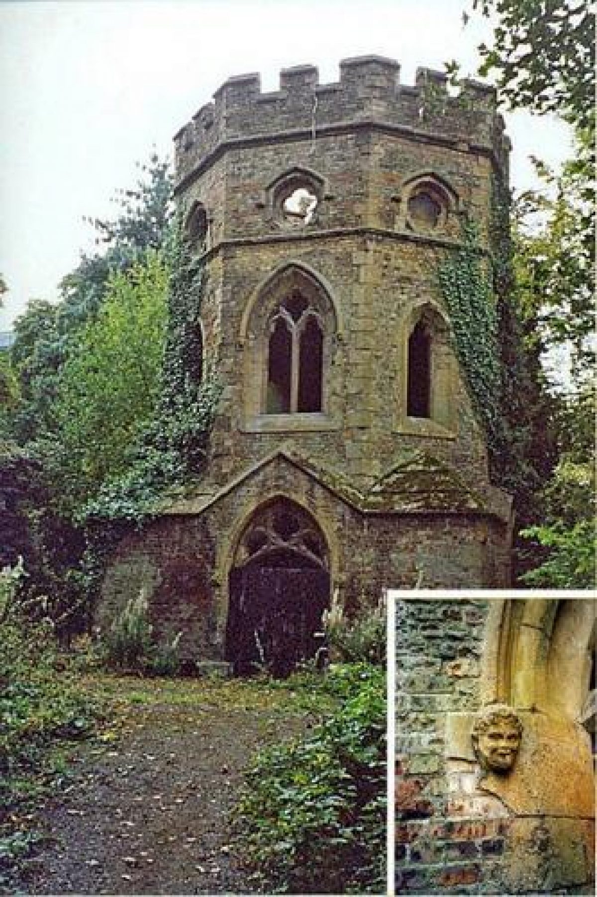
The wide tarmac path along the top of the terrace continues past first Gunnersbury Park and then Gunnersbury House. To the east of the latter, north of the terrace, is the site of the abandoned herbaceous garden. The path continues along the terrace and through an early C19 arcade (listed grade II as part of a complex of a late C18/early C19 gothic outbuildings to the south). The arcade has four Tudor arches and a battlemented top. The outbuildings include a grotto shelter, and a room known as Princess Amelia's Bath House. Derelict in 1999, these buildings have attracted grant aid with a view to restoration. The path terminates at the eastern boundary wall alongside Gunnersbury Avenue. From this point a path leads south to the east of the gothic outbuildings and continues alongside the eastern boundary wall, over the sham bridge, to the Gothic Ruins. Listed grade II, the brick-built ruins were made for the Rothschild family in the mid C19. To the south of the Ruins is the Japanese Garden; constructed on land which formerly belonged to the Gunnersbury House estate, the garden, which was carefully designed by James Hudson (gardener to Leopold Rothschild) after Japanese models, was completed just after 1900. To the south-east of the Japanese Garden are the stables (listed grade II) built by Sidney Smirke for Nathan Rothschild, with the north range constructed on the border with the Gunnersbury House estate. In order to screen the buildings, Thomas Farmer decorated his side with Gothic-style elevations. The path continues to the west of the stables and into the parkland.
PARK
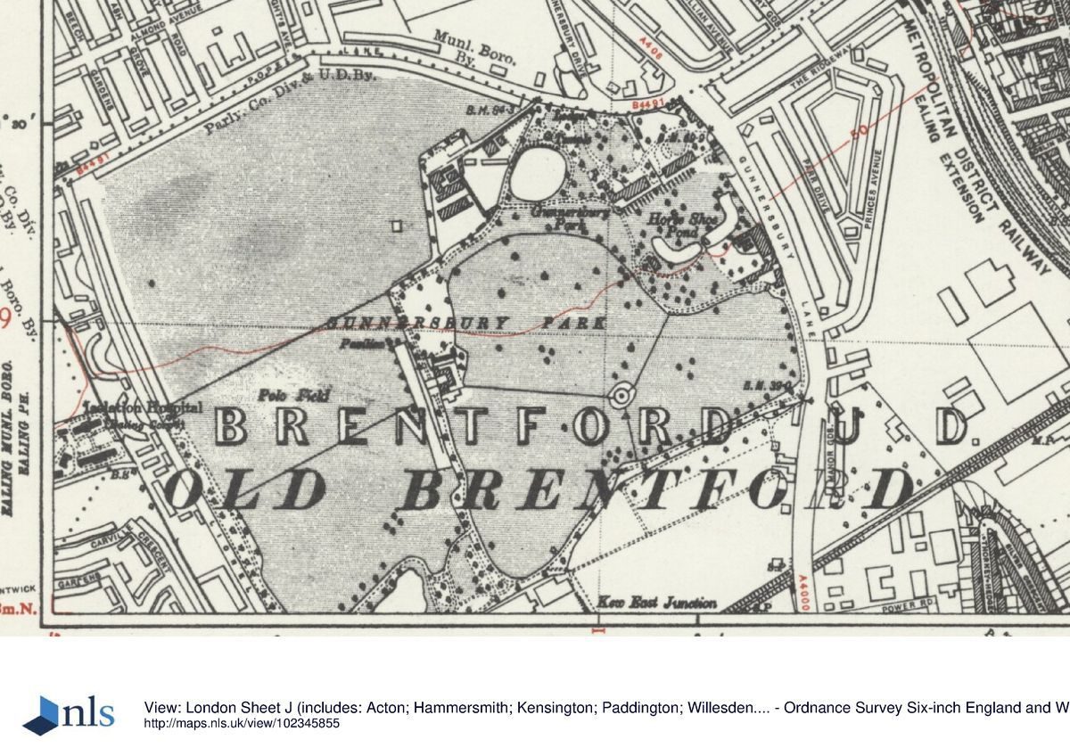
The c 60ha of open parkland extends from the south round to the north of the pleasure grounds. The park is today (1999) given over to recreation. A public golf course dominates the central area with sports pitches and open areas to the west and the south. Boundary planting shown on an estate map of 1847 (Kretschmar) survives and it was after this date that the Rothschilds expanded the parkland to the west, using part of the land as a Polo field and part for agricultural purposes. In addition to farmland, in 1861 the Rothschilds acquired a former clay pit and tile kiln to the south-west of the property, transforming the pit into the Potomac Pond and the kiln into the Gothic Boathouse (listed grade II). J W Pulham was responsible for the elevations of the boathouse and also for the rockery that decorates the path to the east of the lake.
KITCHEN GARDEN
The walled Kitchen Garden, which lies immediately to the west of the Round Pond, is not open to the public. Its is currently (1999) used by two private organisations as a commercial nursery and for horticultural training. The ground was included in the estate by the beginning of C19 and is shown as Lot 3 on the Sale map of 1802. The OS map of 1865 shows a number of glasshouses and fruit trees in the area. As well as fruit and exotic plants the gardens were famous for their vineries, orchids, and pineapples (guidebook 1993).
REFERENCES
Lysons and Brewer, Beauties of England ... and Middlesex (1816), p 339
T Faulkner, Brentford, Ealing and Chiswick (1845)
Journal of the Royal Horticultural Society, 32 (1907), pp 1-10
B Jones, Follies & Grottoes (1974), p 329
Butcher et al, Gunnersbury Park ( Aspects of Conservation, (unpublished report, Architectural Association 1993) [copy on EH file]
Gunnersbury Park and The Rothschilds, guidebook, (Hounslow Leisure Services 1993)
Maps
J Rocque, Plan of the Cities of London and Westminster and Borough of Southwark, published 1746
W Nichols of Brentford, Map of the Parish of Ealing, 1777, revised 1822 (reproduced in Butcher et al 1993)
Plan as part of an Identure showing 13 lots, 1802 (reproduced in guidebook 1993)
Tithe map of Ealing parish, 1839 (reproduced in Butcher et al 1993)
E Kretschmar, Map of Gunnersbury Park, 1847 (reproduced in guidebook 1993)
OS 25" to 1 mile: 1st edition published 1865
2nd edition published 1891
3rd edition published 1913
1935 edition
Archival items
Gunnersbury Park Museum Archives (London Borough of Ealing)
Description written: December 1999
Edited: June 2001
- Visitor Access, Directions & Contacts
Access contact details
This is a public park open daily from 8am to dusk. Please see: http://www.hounslow.info/parks-open-spaces/find-your-park/gunnersbury-park/ or telephone 020 8992 1612
Directions
Tube: Acton Town (Piccadilly, District) then bus. Rail: Kew Bridge then bus. Bus: E3, H91
Owners
London Borough of Enfield
- History
The following is from the Register of Parks and Gardens of Special Historic Interest. For the most up-to-date Register entry, please visit the The National Heritage List for England (NHLE):
www.historicengland.org.uk/listing/the-list
HISTORIC DEVELOPMENT
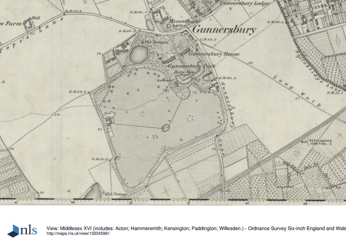
The area in which Gunnersbury Park is situated was, in the Middle Ages, an estate owned by the bishops of London, part of the Manor of Fulham. By 1656 Gunnersbury had been purchased by Sir John Maynard (1602-1690). Maynard engaged the architect John Webb (1611-1672), pupil and relative of Inigo Jones, to build a new manor house on the estate. Gunnersbury estate was purchased by Henry Furness, MP and art collector, in 1739. A map surveyed in 1741 (Rocque, 1746) shows a formal layout south of the house, with the main axis, at one point flanked by formal canals, aligned on the house and continuing south through the pleasure grounds in the form of an avenue. It is thought (Butcher et al 1993) that Furness engaged William Kent, who he knew socially, to enlarge and alter the estate. Kent's professional connection is evident from a payment of £55 received from Furness in April 1743. Princess Amelia, favourite daughter of George II, purchased Gunnersbury Park in 1761 and set about improving and extending the estate. Princess Amelia enjoyed entertaining at Gunnersbury and her guests included Horace Walpole, who was then living at Strawberry Hill, Twickenham.
The Princess continued to use Gunnersbury as her summer residence until her death in 1786, after which the property passed through a number of owners until 1800 when it was purchased by John Morley, a floorcloth manufacturer of Chelsea. Morley demolished the Webb house and divided the estate into thirteen lots, with a view to development, thus causing the creation of two separate estates, a partition which was to last for eighty-seven years. In 1802 Alexander Copland (about 1774-1834), a partner of the architect Henry Holland, bought ten of the thirteen lots and Stephen Cosser bought Lot 1, the north-east side of the estate. Copland subsequently purchased the remaining two lots, having already built himself 'The Large Mansion', Gunnersbury Park. 'The Small Mansion', Gunnersbury House, was built to the east either by Cosser (Lysons and Brewer 1816), or his successor Major Alexander Morrison, who bought the former Lot 1 land in 1807 (Faulkner 1845). In 1828 the Gunnersbury House estate was purchased by Thomas Farmer who lived there, with Copland as his neighbour, until 1835 when Gunnersbury Park was bought by Nathan Mayer Rothschild. The new owner immediately contacted J C Loudon about improving the approach to the house from Pope's Lane. It is not known if Loudon's proposals were put into effect. Rothschild died the following year, having never resided at Gunnersbury, but the Rothschild family, who in 1889 reunited the site, continued to live at Gunnersbury until 1925. During that time Lionel Rothschild bought land to the south-west including a clay pit which he made into a pond. The family continued to improve the estate and Gunnersbury became renown for its horticultural excellence and often featured in the gardening press of the late 19th and early 20th centuries.
After the death of Leopold de Rothschild in 1917 the estate was broken up and gradually sold off. In 1925 75 hectares, including both houses and the garden buildings, were purchased for public use by the then boroughs of Acton and Ealing, with Middlesex County Council contributing to the cost. The park was formally opened to the public by Neville Chamberlain, MP, on 21 May 1926. In the early years of the park's public ownership many of the horticultural practices continued, but with increased provision for recreation. During the Second World War the playing fields accommodated anti-aircraft positions and new roads were made.
The park continues (1999) in public ownership.
Period
- 18th Century (1701 to 1800)
- Late 18th Century (1767 to 1800)
- Associated People
- Features & Designations
Designations
Conservation Area
- Reference: Gunnersbury Park
The National Heritage List for England: Register of Parks and Gardens
- Reference: GD1801
- Grade: II*
Site of Local Importance for Nature Conservation
Features
- Temple
- Folly
- Lake
- Pond
- Pulhamite
- House (featured building)
- Now Museum
- Earliest Date:
- Entrance
- Description: Main entrance on Pope's Lane
- Gate Lodge
- Description: North Lodge and East Lodge.
- Arch
- Earliest Date:
- Latest Date:
- Orangery
- Arcade
- Grotto
- Bath House
- Stable Block
- Boat House
- Key Information
Type
Park
Purpose
Recreational/sport
Principal Building
Education
Period
18th Century (1701 to 1800)
Survival
Extant
Hectares
70.96
Open to the public
Yes
- References
References
- {English Heritage Register of Parks and Gardens of Special Historic Interest} (Swindon: English Heritage 2008) [on CD-ROM] Historic England Register of Parks and Gardens of Special Historic Interest
- Hitching, C {Rock Landscapes: The Pulham Legacy} (Garden Art Press, 2012) Rock Landscapes: The Pulham Legacy
- {Gunnersbury Park Landscape Restoration Plan} (1996) Gunnersbury Park Landscape Restoration Plan
- Masters, Philip for Chris Blandford Associates{Gunnersbury Park Appraisal of Historic landsape Issues in the Heritage Lottery Fund Bid} (1998) Gunnersbury Park Appraisal of Historic landsape Issues in the Heritage Lottery Fund Bid
Contributors
London Parks and Gardens Trust