
Introduction
Dyrham Park has the remains of an early formal garden layout and landscape park. Most of the features of the formal garden are no longer extant. The gardens extend to around five hectares, while the park covers some 105 hectares.
The grounds of Dyrham Park can be divided into two sections. The great bulk of the site, some 100 hectares, is parkland dotted with individual mature trees. Species include horse chestnut, sweet chestnut, oak, ash, lime and various cedars. A herd of fallow deer is kept in the park, and some 16 hectares are used for arable farming. Both the park and farmland are carefully managed, and there is a continuing programme of tree felling and tree planting.
To the west of the mansion house there is a 4.5 hectare formal garden, centred around two fishponds thought to be Elizabethan. This area is tended by a full-time gardener and there is an on-going programme of tree planting here. In 1983 the larger of the two ponds was cleaned out and its walls were restored.
Public access to Dyrham Park is normally through the main gates on the A46. From there a metalled drive leads down through hills and a large area of parkland to the mansion house. The mansion house is situated at the convergence of several small valleys, and much of the impact of both the house and grounds is derived from this natural situation. To the west of the mansion house is the formal garden which is on flatter ground. There are many trees in the park of varying ages. These are listed in the features section.
The following is from the Register of Parks and Gardens of Special Historic Interest. For the most up-to-date Register entry, please visit The National Heritage List for England (NHLE):
The remains of a 17th century park and garden layout by George London, with a late 18th/early 19th century landscape park around a country house.
Location, Area, Boundaries, Landform and Setting
Dyrham Park extends to c 105ha and is located on the sandstone escarpment of the southern Cotswolds c 9km north of Bath. The house sits at the foot of the slope, adjacent to the C13 St Peter's church, and parkland rises steeply to the east and north. The park, which is encompassed by a drystone wall and shelter belts to the south and east, is bounded to the east by the A46, Bath to Gloucester road, and to the south by a lane, Sands Hill, which leads from the A46 to the village. The western boundary follows the boundaries of properties in the village of Dyrham. To the north-west and north, the boundary follows an old lane south of prehistoric strip lynchets and Dyrham Camp, an Iron Age hillfort, on Hinton Hill c 1km north of the house, and part of Field Lane north of Badminton Plantation, c 1km north-east of the house. To the east there are two high points within the park, Umbrella Hill and Neptune Hill, and to the west the land falls gradually towards the Avon valley and the eastern suburbs of Bristol beyond the villages of Pucklechurch and Wick.
Entrances and Approaches
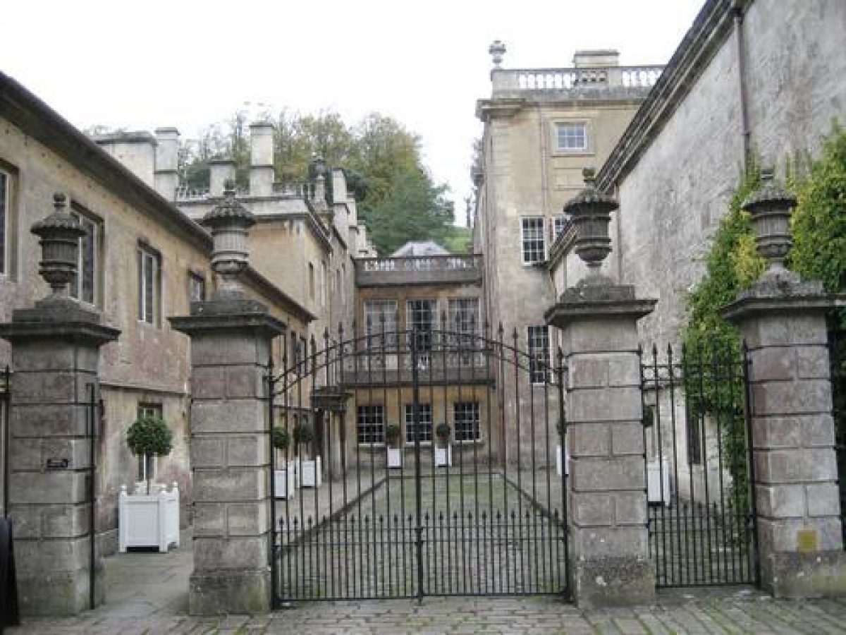
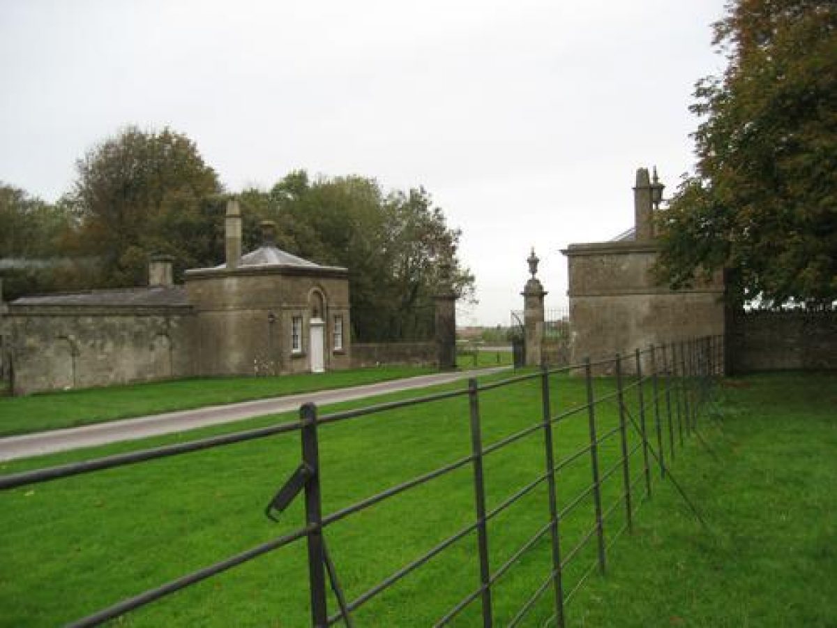
A straight walk approaches the house from the gates (c 1800, listed grade II) into the village, c 150m from the west front. A service drive approaches east of the stables and house directly from Sands Hill, 200m to the south of the house. Two lodges (late C18/early C19, listed grade II), 700m east of the house, mark the eastern entrance to the park from the A46. From these lodges, the approach passes north of a car park, built in the 1990s by the National Trust. The drive then enters a recently planted avenue (c 1990s?), along which it heads west for c 400m, before turning south through a sharp dog-leg and descending the scarp to the south of Neptune Hill and approaching the east front of the house from the south-east. A bird's-eye view by Kip (Atkyns 1712), showing the west front of the house, records a coach and horses approaching from behind the house to the east, via a curving tree-lined road south of Neptune Hill and along a straight drive beside a water garden. Harcourt Masters remodelled this approach (c 1798-1800), laying out a new approach to the south of the old drive, but he used the same entrance from the turnpike; the lodges were possibly designed by him.
At the junction of Sands Hill and the A46 there is a disused gateway in the wall (early C19, listed grade II) but there is no surviving evidence of an approach to the house from this point.
Principal Building
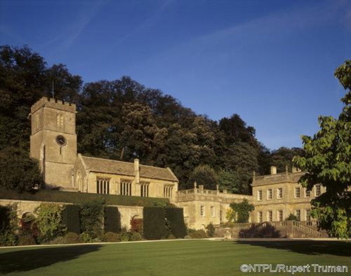
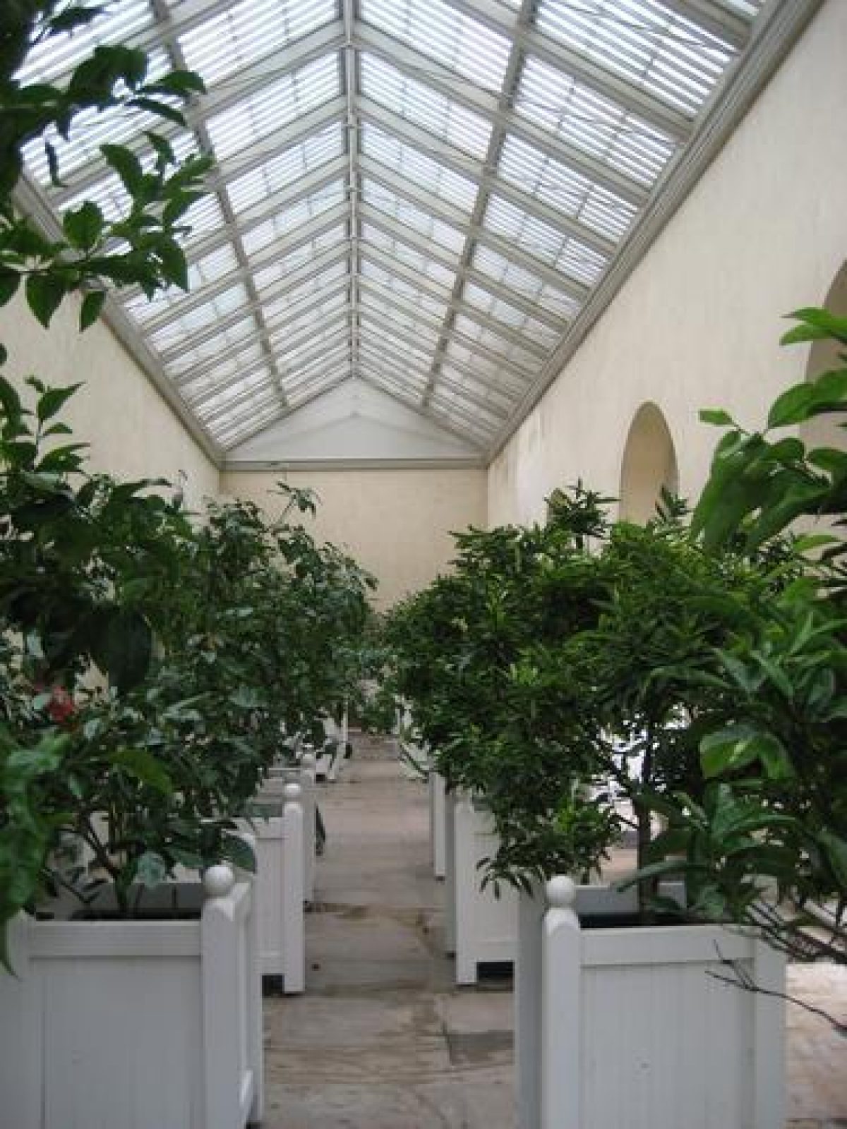
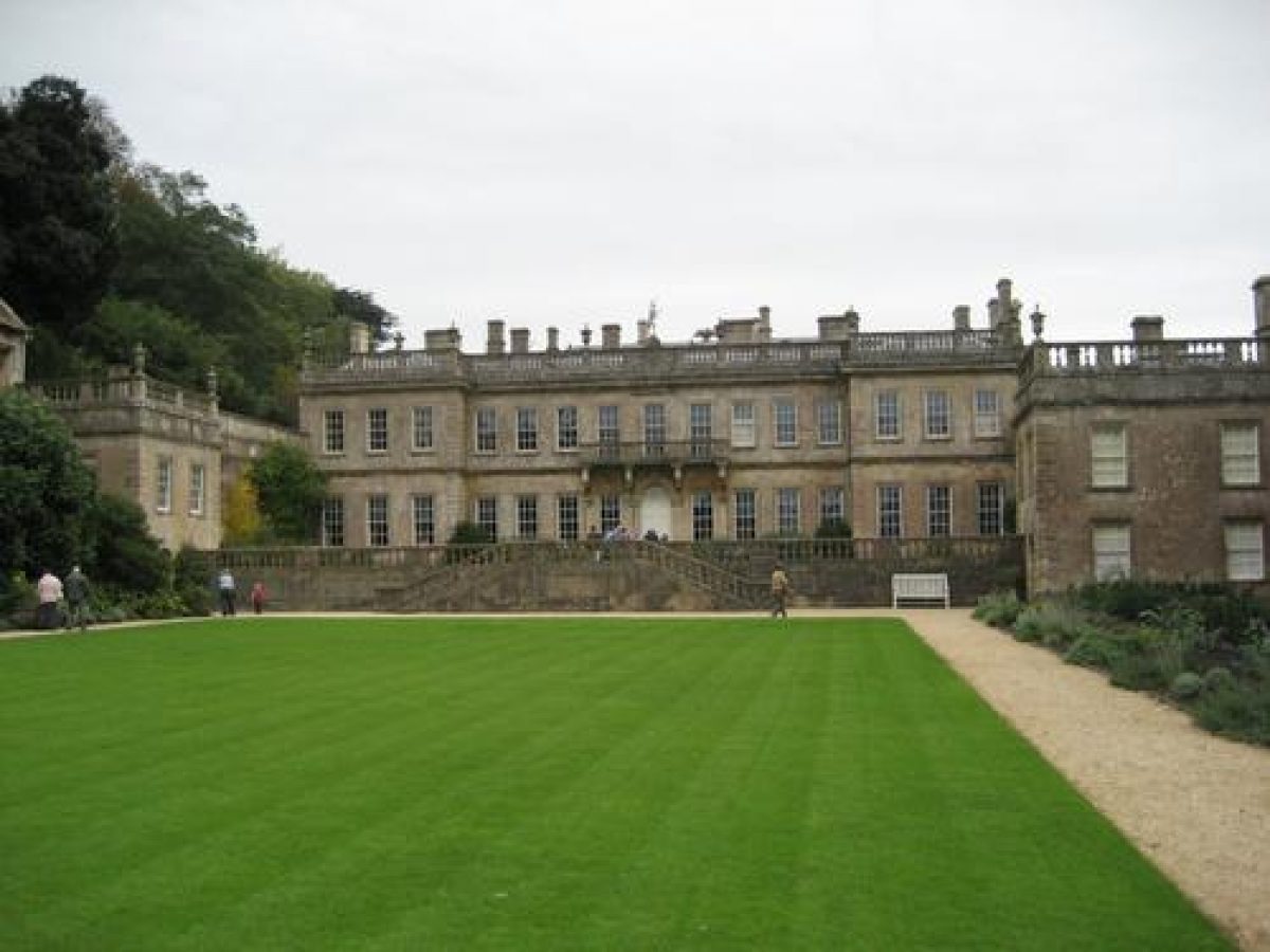
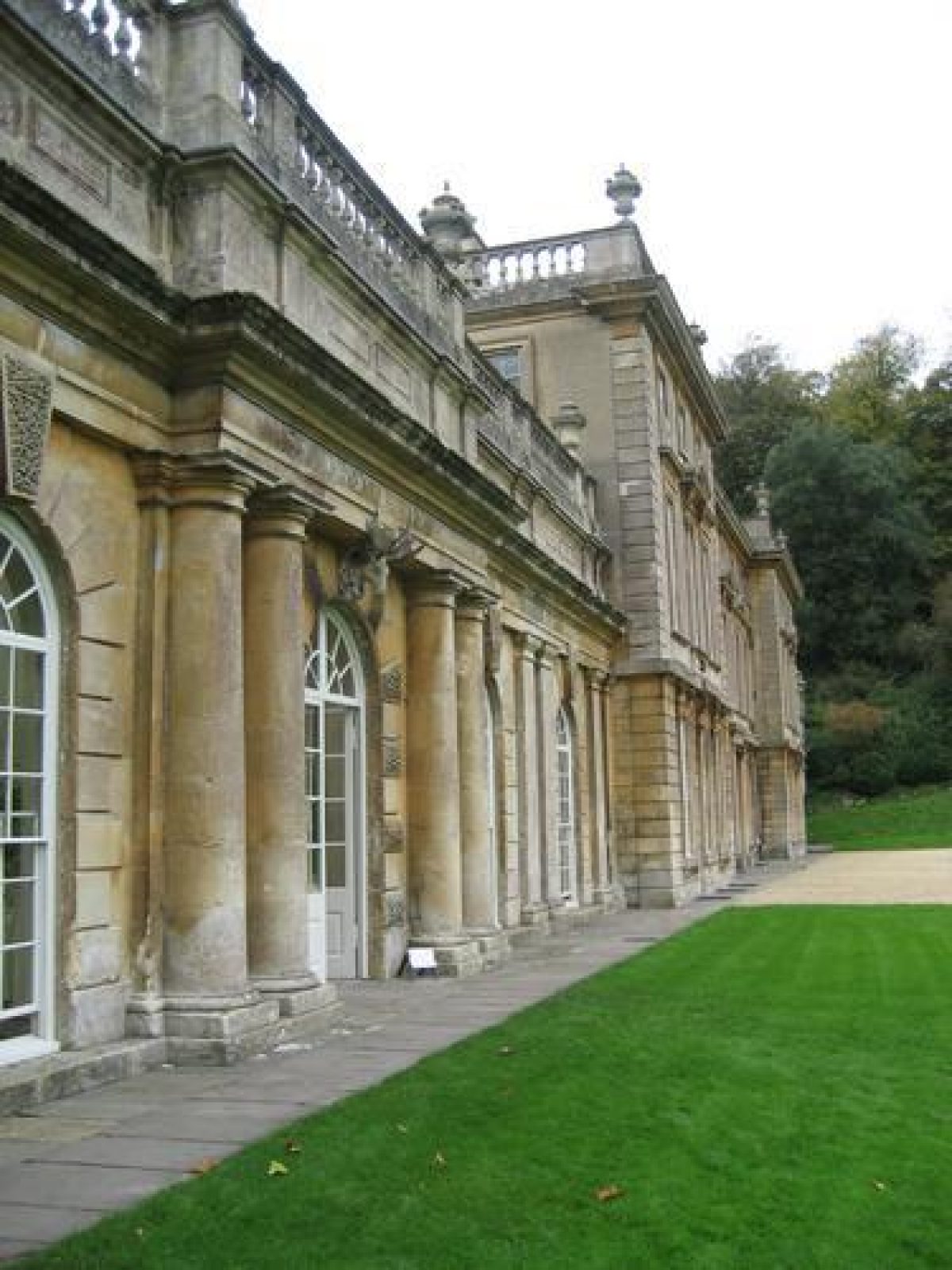
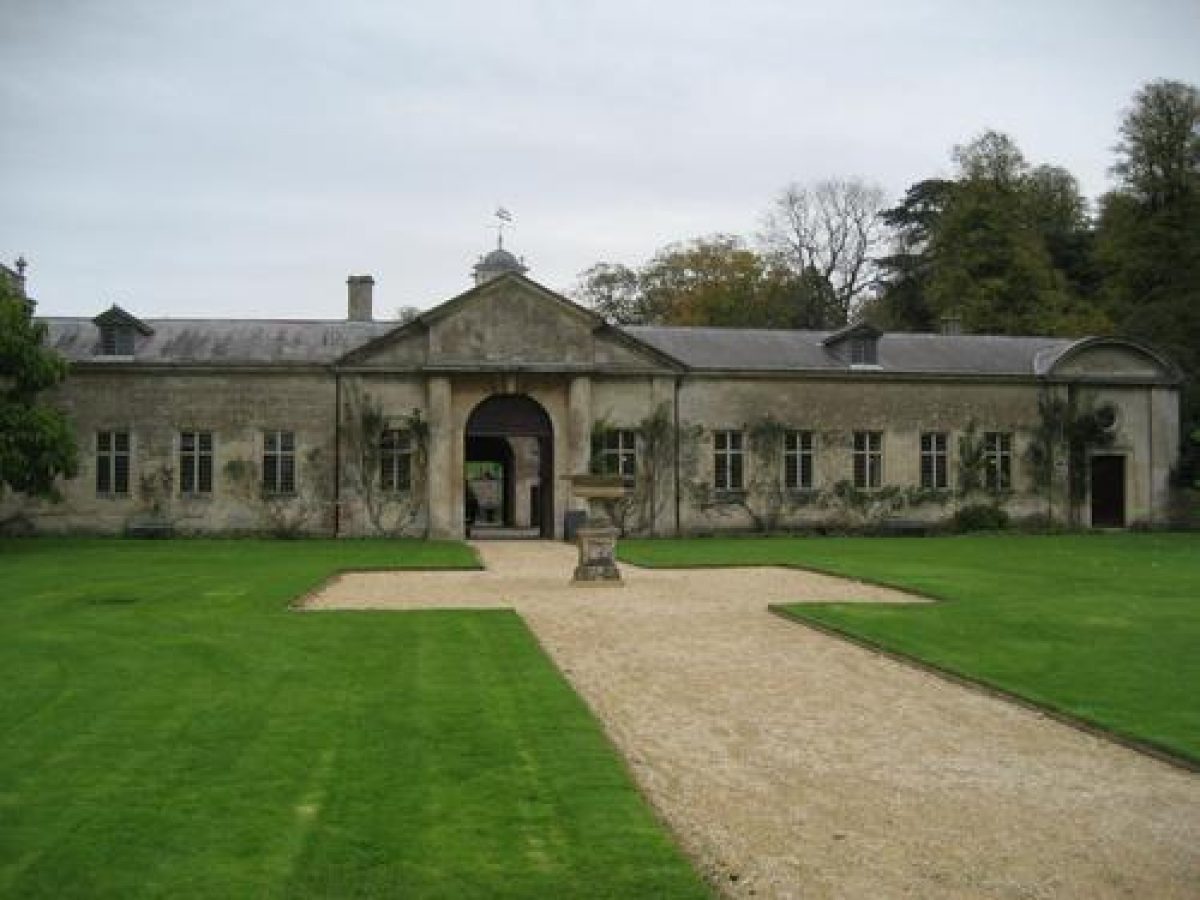
The house, Dyrham Park (late C17/early C18, listed grade I), has a Tudor core, but was largely rebuilt for William Blathwayt. The west front, designed as the entrance front by the relatively obscure Huguenot architect, Samuel Hauduroy was completed by 1694. The house stands on a balustraded terrace of the same date, approached by a double flight of steps aligned with the gates into the village. The east front, which physically and stylistically forms almost a separate building, was designed by the Comptroller of the King's Works, William Talman (1650-1719) and was finished by 1703. Attached to the southern end of the façade is an orangery (Talman 1701, listed grade I) and to the western façade, a stable block (Talman 1698-9, listed grade I). Some 80m south of the house is a pavilion (late C17), one of two shown in Kip (Atkyns 1712), now attached to Hind's Cottage (C18, listed grade II). Some 30m to the north-west of the house, on an elevated terrace, stands the church of St Peter (mid C13, listed grade I), forming what Verey and Brooks (2002) call 'the perfect English setting - house, church, and stables, all of stone, forming a single unified group'. The south aisle, seen from the house and gardens, was restored by William Blathwayt after 1688.
Gardens and Pleasure Grounds
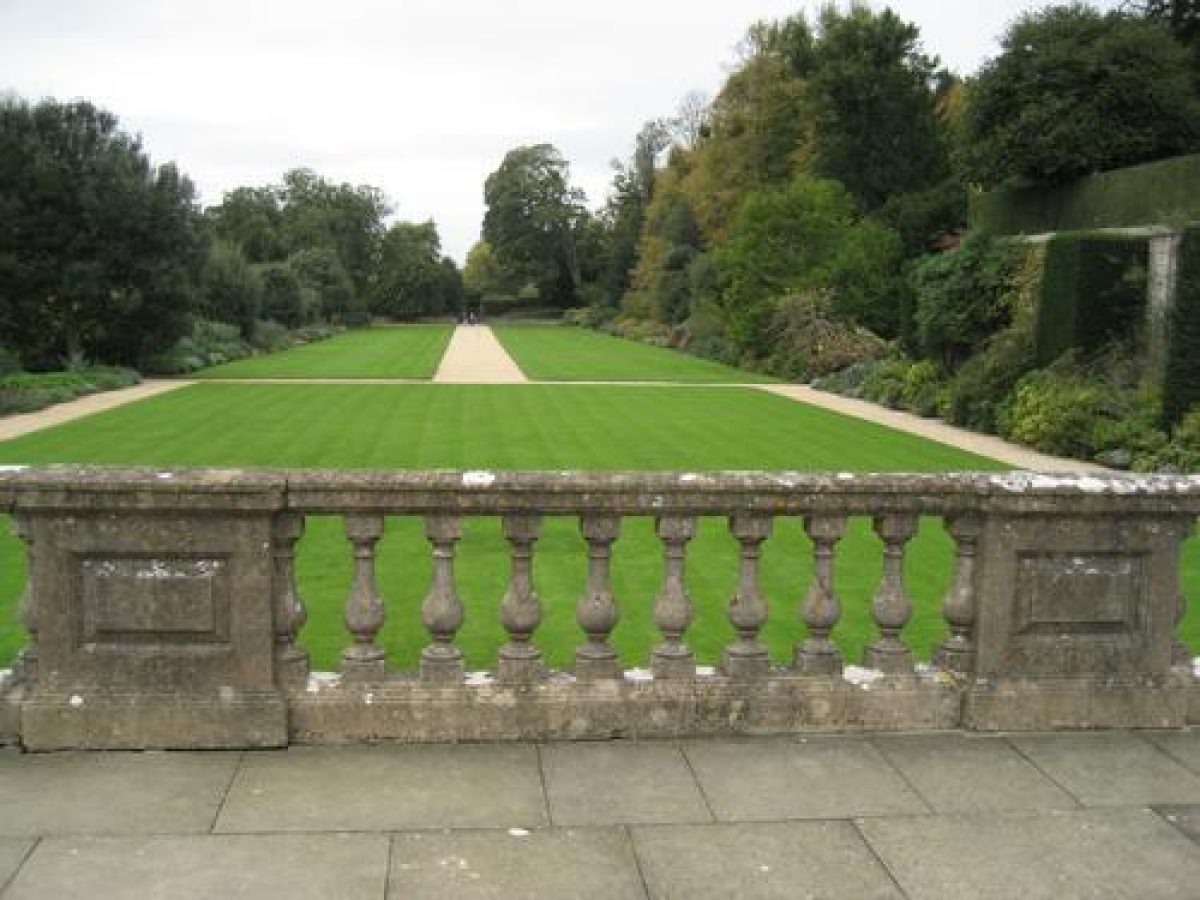
The gardens at Dyrham Park are located to the west, between the house and the village. The assemblage of house, church, and churchyard are bounded to the north by a steep slope, terraced as part of the late C17 garden layout, the church and churchyard themselves being on a terrace above the level of the house and garden. Some 50m north of the house is the Church Walk, marked by large lime pollards which may date from the late C17. Above and north of the churchyard are overgrown terraces from the late C17 layout recorded by Kip (Atkyns 1712). On the slopes north of the church are remains of formal walks which run eastwards from a former Wilderness, laid out as part of the early C18 improvements, c 100m north-east of the house. Only the top walk survives as a levelled accessible walk but the line of the other former terraced walks is still clear. There is a beech hedge along the top terrace, C18 lime trees along the middle terrace, and a line of late C17/early C18 yew trees down the slope, east of the church tower, on the line of steps recorded by Kip (ibid). The lower terraces seem to have been deliberately smoothed as part of the late C18 landscaping, as recorded on a watercolour bird's-eye view of the 1790s. A substantial stone retaining wall, shown in Kip (ibid), divides the top walk from the park to the north.
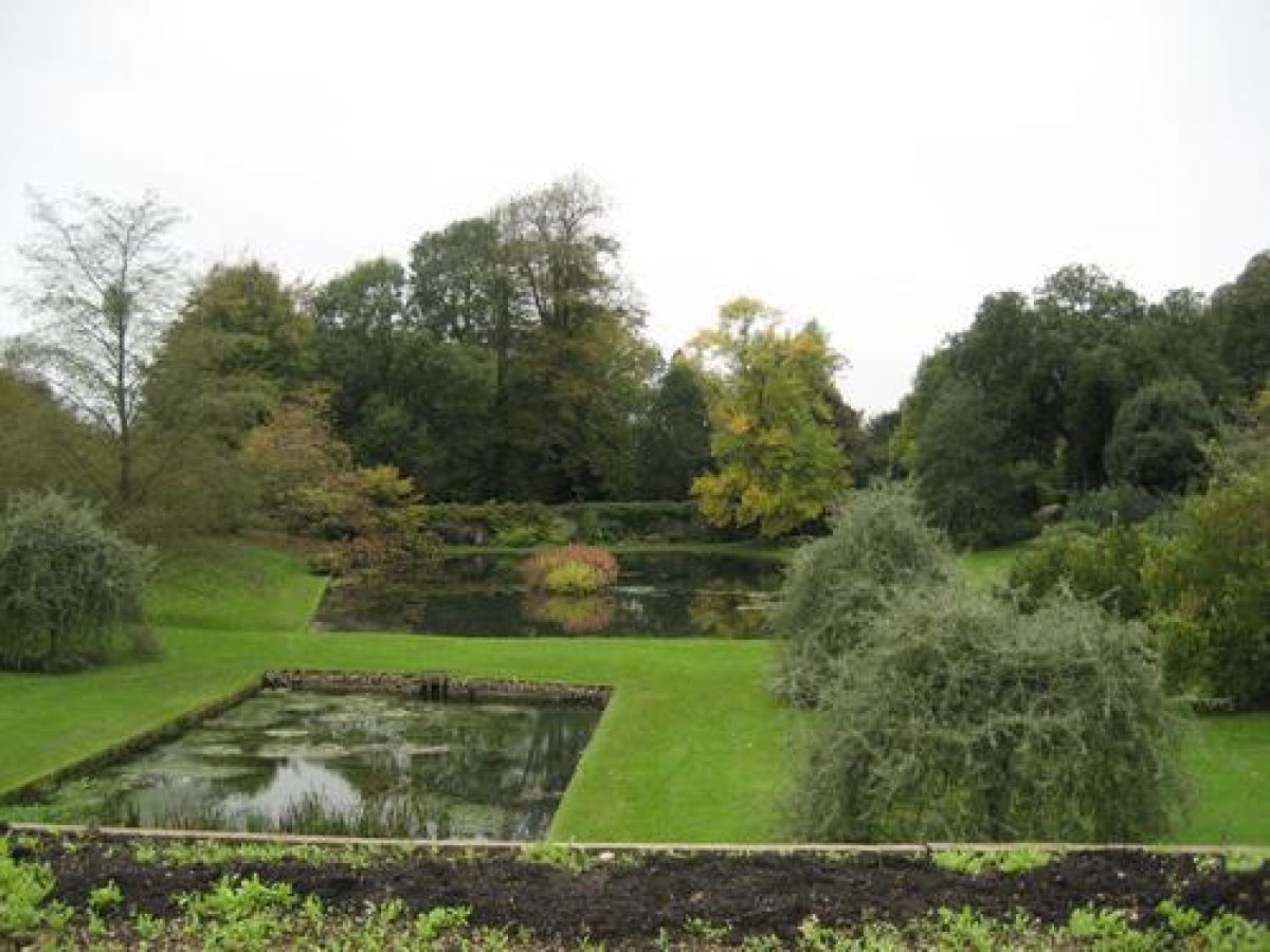
The west garden comprises three elements. West of the west front of the stable block is a lawn, formerly a paddock, ornamented with a scattering of ornamental trees (post 1958) including an Atlantic cedar, catalpas, and two Judas trees. A path with holm oaks planted along its south side, the Long Walk, stretches c 200m westwards below the churchyard from a terrace outside the west front of the house, to the entrance gates from the village. A stone retaining wall to the churchyard on the north side of the Long Walk is fronted by herbaceous borders. The holm oaks divide the main lawn from the third area of the west garden, a sunken area centred on two ponds. At the eastern end of this sunken area is a stone-built cascade (late C17, listed grade II), fed by a pond on the scarp to the east of the house via a canal between the house and the stable courts, which issues into the eastern of two ponds which date back at least to 1689 and probably originated as medieval fishponds. Parchmarks in the grass show evidence of a lost apsidal-ended rectangular pond, shown between the two existing ponds in Kip (ibid). A fine black mulberry tree stands just to the north, and remnants of a late C19 rock garden occupy the north-east corner of this sunken area. The line of a shrubbery walk running westwards along the north slope of the area leads to a blocked door in the western garden wall, formerly opening onto the village street. In the village to the west (outside the site here registered), a stream issues from the two ponds in the west garden and is culverted beneath the road, emerging via a cascade into an area of C19 trees and shrubs. In the C19 a shrubbery walk was laid out along this stream, running westwards for some 350m along a sequence of pools and cascades.
South of the ponds in the west garden is a nut-walk running east/west, planted by the National Trust after 1958. Further south is a former pear orchard with a few old perry pear trees and additional specimen tree-planting by the National Trust. Screen-planting on the south side of the orchard includes two large limes, beech, yew, holm oak, bird cherry, and Scots pine, with a holly and laurel understorey.
Park
The park, which lies north, east, and south-east of the house, rises sharply in all three directions from the house to a plateau. The park to the north and east of the house is scattered with possibly C17 open-grown lime trees, as well as C18 and C19 horse chestnut, London plane, beech, and oak. One cedar of Lebanon survives of a group which stood close to the north-east corner of the house, as recorded in early C19 views (West, 1821). Near the house are C19 specimens, including tulip tree, red oak, and black walnut. The Warren, an area of parkland some 400m north of the house, rises to a hill some 100m above the surrounding plateau which formed a viewpoint noted by Switzer in 1718. The Warren was formerly a separate enclosure, planted with six elm avenues which survived until killed by Dutch elm disease and felled in 1976, when they were aged c 270 years. Some 250m north-east of the house in the park stands Old Lodge, on the site of an earlier ox-house. It was built c 1702, and in 1710 had inner and outer rooms upstairs with one other room downstairs; it was largely rebuilt in the C19. North of the lodge was the late C17 2ha nursery which was brought into the park by 1833. Old Pond Wood, some 400m east of the house, was formerly The Great Pond, constructed c 1698-9, which had walks round it; in 1886 it was recorded as an aviary (Fretwell 1997).
The park east of the house is a smoothly undulating incline, rising steeply from the house towards the eastern boundary. In Kip's view of 1712 (Atkyns) this area is shown as an extensive late C17/early C18 garden between the house and Neptune Hill, 320m to the east. The whole area was laid out with terraces, water features, and formal gardens. Apart from the remnants of three avenues of trees arranged in a goose-foot shape in the east of the park, there is little visible on the ground of this formal arrangement, although archaeological remains are thought to survive on and west of Neptune Hill. The remodelling in the late C18 by Harcourt Masters appears to have been thorough, the only clear reference point being the statue of Neptune (early C18, listed grade II*) which stands on the site of the top of a former cascade. The late C17/early C18 garden design has been attributed to George London, on the basis of Blathwayt referring in correspondence to delaying a decision on the Slope Garden layout until he has seen him, but there is no surviving plan (Fretwell 1997). Thomas Hurnall, Blathwayt's gardener, produced designs for the top of the cascade, and corresponded at length with Blathwayt over the garden's development. It seems possible that Talman may also have been consulted. Blathwayt's accounts, however, record that seeds and plants for the garden and the park were certainly supplied by London (ibid). Four large London plane trees immediately south-east of the Orangery seem to date from the late C18/early C19.
The parkland here registered was formed after 1620 when licence was granted to impark and stock lands in the Manors of Dyrham and Hinton, and was successively enlarged by the addition of small parcels of land in 1666, 1670, 1690-3, and 1708, with the further additions in 1800-4 of the former parish fields, White Field and Upper Field (Fretwell 1997). A fragmentary network of avenues across the park was recorded in 1766 (Coates), many of which survived into the 1970s, including one running east/west along the former southern boundary of the park, prior to the enclosing of the White Field, and two symmetrical avenues running north-west and south-west from the main avenue, either side of the main approach. An extensive replanting programme of lime trees has been established by the National Trust in this area. An earlier deer park, enclosed in 1511, occupied land south of Sands Hill, around Dyrham Wood, south of the present park. It was separate from the house, and is now entirely outside the site here registered. It was probably disparked c 1620.
Kitchen Garden
The walls of a former kitchen garden survive, located to the west of the village street and outside the area here registered; the area now contains two private dwellings built in the 1970s. The c 3m high walls are of rubble sandstone with openings of Bath stone ashlar.
Description written: October 2002
Edited: September 2003
- Visitor Access, Directions & Contacts
Telephone
0844 800 1895Website
http://www.nationaltrust.org.ukAccess contact details
The gardens are open from March to December, every day at high season but only on weekends through the winter. http://www.nationaltrust.org.uk/place-pages/119/pages/opening-times-calendar
Directions
The gardens can be reached from junction 18 at the M4, then via the A46.
Owners
The National Trust
Heelis, Kemble Drive, Swindon, SN2 2NA
- History
16th - 17th Century
The estate of Dyrham was acquired by the Wynter family in 1571, and a licence was granted to Sir George Wynter in 1620 to empark and stock lands in the manors of Dyrham and Hinton.
William Blathwayt gained possession of Dyrham in 1689, having married Mary Wynter in 1686. He commissioned a survey of the estate and began to construct an elaborate formal garden. George London was employed to design the garden, which had parterres, terraces, canals, fountains and a large cascade. Thomas Hurnall was gardener at Dyrham.
Letters and accounts now in the Dyrham archives in the Gloucestershire Archives Office document the process of construction between 1691 and 1704. An engraving by Kip (which appeared in Sir Robert Athyn's The Ancient and Present State of Gloucestershire in 1712) is usually taken as providing a good record of how the finished garden looked. A recent discovery of a detailed description of the garden by Stephen Switzer, (published in the Iconographia Rustica Vol. III in 1718), has confirmed that Kip's engraving of the garden was substantially accurate.
18th Century
The construction of the great Baroque garden at Dyrham came at a time when fashions were changing and attitudes to garden design were radically altered. As early as 1709 Shaftesbury had written that 'the wilderness pleases'. By the 1730s landowners were moving away from the formal style of gardening dominated by Le Notre. Instead they favoured a more natural style, which became common by the middle of the 18th century. Blathwayt's elaborate garden was soon a stylistic anachronism.
The subsequent history of the garden is fragmentary. An estate map by Giles Coates (1766) shows much of London's layout surviving, including the canal, terraces, wilderness and nursery. The cascade is not shown. In 1779 Rudder (see references) wrote that 'There is a park adjoining the gardens, but the curious waterworks, which were made at great expense, are much neglected and going to decay'. Ralph Bigland wrote in 1791 of the pleasure grounds 'now reconciled to Modern Taste'.
In 1798-99 C. Harcourt-Masters, a Bath surveyor, had the drive re-routed along its present line, and Anthony Mitchell suggests that actual dismantling of the garden must have gone on before this. Humphry Repton visited Dyrham in 1800 and made some suggestions for landscaping, but these do not appear to have been acted upon.
Today the statue of Neptune is the only surviving remnant of the Baroque garden. However, many of the outlines of the garden may be seen on the ground, particularly in dry weather. The lime trees now in the church walk may date from the late 17th century. Anthony Mitchell suggests that the copper beech in the formal garden may have been Repton's work. Specimen trees have been continuously planted at Dyrham for several hundred years, a process which is actively continuing.
The following is from the Register of Parks and Gardens of Special Historic Interest. For the most up-to-date Register entry, please visit The National Heritage List for England (NHLE):
The earliest suggestion of a park at Dyrham is in the Anglo-Saxon Chronicle, which records the Battle of Deorham in AD 571 or 577, the name being thought to derive either from dwr meaning water and referring to the springs in the area, or from deor hamme, a deer enclosure. The Domesday survey however contains no reference to the place, and the development of the present site dates from a grant of free warren to Robert Walerand in 1259. By 1311 Sir William Russel's estate at Dyrham is recorded as a capital messuage with garden and dovecote.
15th -16th Century
In 1416 Dyrham passed from the Russel family to Sir Gilbert Denys, whose house appears to have been on the site of the present mansion. In 1511 a licence to impark 500 acres (about 202 hectares) in the manor of Dyrham was granted to Sir William Denys, although only some 250 acres (about 100 hectares) appear to have been taken in to form what is now known as the Old Park. Leland (about 1535) records a 'faire howse of Achelie Stones and a fayre parke' at Dyrham (Mitchell 1977/8).
In 1571 Sir Walter Denys sold 'the manor and park of Dyrham' to George and William Wynter of Lydney, the park being recorded on Saxton's 1577 map of Gloucestershire. In 1620 Sir George Wynter was granted licence to impark and stock lands in the manors of Dyrham and Hinton, creating the New Park around the house, and probably resulting in the conversion of the Old Park to farmland. The Wynter family continued to own Dyrham, under increasing financial problems, until the heiress Mary Wynter married William Blathwayt in 1686, who took over the estate after the death of Mary's father in 1689.
17th - 18th Century
Blathwayt, an influential and wealthy member of William III's civil service, Secretary at War 1683-1704 and Secretary of State 1692-1701, commissioned major works to the house and garden in the period 1691-1704, including the elaborate formal layout recorded in Kip's engraving, published by Atkyns in 1712, and in Stephen Switzer's (1682-1745) description of 1718. This comprised an extensive water garden to the east, and terraces and a wilderness to the north. The overall design of the garden is thought to have been by George London (d 1714) (Fretwell 1997).
By 1779, the park and the waterworks are noted by Samuel Rudder as 'much neglected and going to decay', and they had been removed by about 1790. Remodelling of the parkland east of the house including the new approach (c 1798-1800) was overseen by Charles Harcourt Masters (1759-?), a Bath architect and surveyor. Humphry Repton (1752-1818) and John Adey Repton (1775-1860) were paid for designs for minor garden works in 1801 and 1803, including a design for a modest classical pavilion on the terraces north of the house, of which no trace has been found on site.
19th - 20th Century
Little appears to have been done in the 19th century. A cedar plantation features to the north- west of the house in a view of about 1840 (Hullmandel), while other views emphasise the mature, wooded nature of the house's setting. Between 1839 and 1871, Colonel George Blathwayt seems to have been an enthusiastic planter, but the dominant parkland character derives from the remnants of the formal avenue-planting of the late 17th century, overlain with the less formal planting of the early 19th century. The estate remained in the possession of the Blathwayt family until about 1957, when it was bought by the Ministry of Works and transferred to the National Trust, in whose care it remains (2002).
- Associated People
- Features & Designations
Designations
Conservation Area
- Reference: Dyrham
The National Heritage List for England: Register of Parks and Gardens
- Reference: GD1411
- Grade: II*
The National Heritage List for England: Listed Building
- Reference: Dyrham Park
- Grade: I
Features
- Mansion House (featured building)
- Description: Baroque Mansion house. Major work was done at the turn of the 18th century on a former manor house.
- Hedge
- Description: Large mature yew hedge, in the formal garden.
- Specimen Tree
- Description: Silver pear tree, in the formal garden.
- Specimen Tree
- Description: Copper beech tree, in the formal garden.
- Specimen Tree
- Description: Horse chestnut trees, in the formal garden and in the park.
- Specimen Tree
- Description: London Plane trees, in the formal garden and in the park.
- Specimen Tree
- Description: Holm oak trees, in the formal garden and in the park.
- Specimen Tree
- Description: Sycamore tree, in the formal garden.
- Specimen Tree
- Description: Ash trees, in the formal garden and in the park.
- Specimen Tree
- Description: Lawson Cypress tree, in the formal garden.
- Specimen Tree
- Description: Holly tree, in the formal garden.
- Specimen Tree
- Description: Tulip tree, in the formal garden.
- Specimen Tree
- Description: Hazel tree (double avenue), in the formal garden.
- Specimen Tree
- Description: Various cedar trees, in the formal garden. There are also Cedars of Lebanon in the park.
- Specimen Tree
- Description: Various pine trees, in the formal garden. There are Scots pine and Austrian pine trees in the park.
- Specimen Tree
- Description: Manor ash tree, in the formal garden.
- Specimen Tree
- Description: Beech tree, in the formal garden.
- Specimen Tree
- Description: Various maple trees, in the formal garden.
- Specimen Tree
- Description: Turkey Oak tree (with Lucombe oak grafted on) in the park.
- Specimen Tree
- Description: Sweet chestnut tree in the park.
- Specimen Tree
- Description: Walnut tree in the park.
- Statue
- Description: The statue of Neptune is the only surviving remnant of the Baroque garden. It was created by John Harvey of Bath. The statue originally stood in a small pond at the head of a large cascade. It is now isolated in grass at the brow of a small hill. The original trident is missing.
- Earliest Date:
- Latest Date:
- Icehouse
- Description: There is continued speculation about the existence of an ice-house at Dyrham Park. Despite this the feature has been given a number in the Avon County Sites and Monuments Record.
- Orangery
- Description: A large orangery adjoins the south wing of the mansion house. This can be considered more as part of the house than as a garden building. It is currently used as a cafeteria, although shrubs are grown along the back wall of the orangery. Several orange trees in tubs were standing outside the orangery when the site was visited in winter 1984.
- Key Information
Type
Estate
Purpose
Ornamental
Principal Building
Heritage Site
Survival
Part: standing remains
Hectares
110
Open to the public
Yes
Civil Parish
Dyrham and Hinton
- References
References
- Mitchell, Anthony {The Park and Garden at Dyram} (Kettering, 1977) The Park and Garden at Dyram
- Atkyns, Robert {The Ancient and Present State of Gloucestershire} (London: W. Bowyer for Robert Gosling, 1712) The Ancient and Present State of Gloucestershire
- Switzer, Stephen {Ichnographia rustica : or, the nobleman, gentleman, and gardener's recreation} (London: printed for D. Browne, B. Barker and C. King, W Mears, and R. Gosling, 1718) Ichnographia rustica : or, the nobleman, gentleman, and gardener's recreation
- Coates, Giles {Estate map of Dyrham Park} (1766) Estate map of Dyrham Park
- Rudder, Samuel {A New History of Gloucestershire} (Cirencester: S. Rudder, 1779) A New History of Gloucestershire
- {List of Buildings of Architectural and Historical Interest, County of Avon} List of Buildings of Architectural and Historical Interest, County of Avon
- Pattern, John {How the Deer Park Began} (1971) How the Deer Park Began
- Blathwayt family {Blathwayt family papers} Blathwayt family papers
- {English Heritage Register of Parks and Gardens of Special Historic Interest} (Swindon: English Heritage 2008) [on CD-ROM] Historic England Register of Parks and Gardens of Special Historic Interest
- Teasdale Environmental Design {Dyrham Park, Gloucestershire. Conservation Plan for the Garden, Park and Wider Estate} (2004) Dyrham Park, Gloucestershire. Conservation Plan for the Garden, Park and Wider Estate
- Bigland, R., (1791) Historical, Monumental, and Genealogical Collections relative to the County of Gloucester
- Kingsley, N., (1992), pp 128-133 The Country Houses of Gloucestershire: Volume Two, 1660-1830
- Fretwell,, K, A., (National Trust 1993) Dyrham Park and Garden Survey 1990-3
- Mowl, T., (2002) Historic Gardens of Gloucestershire
- Verey, D., and Brooks, A., (2002), pp 339-46 The Buildings of England: Gloucestershire I The Cotswolds
Contributors
Avon Gardens Trust
E.T. Thacker