Introduction
Dodington House has a landscape park of around 240 hectares. This record was checked with South Gloucestershire Historic Environment Records Officer - June 2010.
The historic gardens survey team were not granted access to this site and therefore cannot comment on its condition.
The following is from the Register of Parks and Gardens of Special Historic Interest. For the most up-to-date Register entry, please visit the The National Heritage List for England (NHLE):
www.historicengland.org.uk/lis...
Well-preserved landscape park with designs by Capability Brown, c 1764, William Emes, c 1793, and John Webb, early C19.
DESCRIPTION
LOCATION, AREA, BOUNDARIES, LANDFORM, SETTING
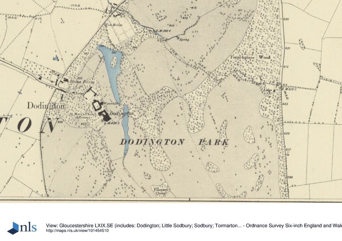
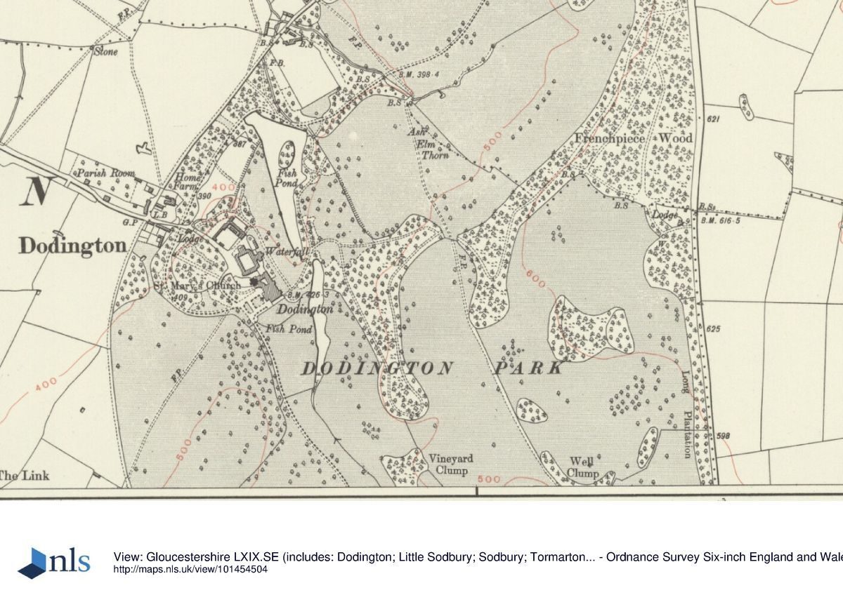
Dodington Park comprises some 240ha on the west-facing slopes of the southern Cotswolds, c 4km east of Chipping Sodbury. Its eastern boundary is formed by the A46, Bath to Stroud road, and its north and north-west boundary by the A432, Chippenham to Sodbury road. The village of Dodington stands immediately outside the west entrance, c 300m north-west of the House, while the south-west boundary is formed by the lane that runs from the village to the A46. From the Bath to Stroud road the land descends c 200m to the level where the House is located, affording the variety much commented on by visitors. In the early C19 Brewer noted:
'The power of contrast is seldom more forcibly exhibited than to the traveller who quits the uninteresting adjacent country, and enters the domain of Dodington. This lovely territory would, indeed, seem to stand by itself, quite unconnected with the surrounding scenery'. (Brewer 1825-7)
ENTRANCES AND APPROACHES
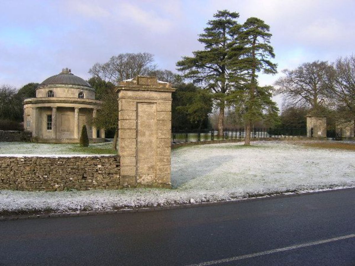
The principal approach to the House descends from the Bath to Stroud road, entering the park some 1.5km south-south east of the House via two massive rusticated gate piers, set in the centre of a 90m wide semicircle of cast-iron railings (piers, dwarf wall, and railings early C19, listed grade II), at the southern end of which stands James Wyatt's Bath Lodge (1796-1816, listed grade I), a circular Tuscan tempietto with a shallow dome. The approach leads north-west through a perimeter belt and Dodington Wood before descending a long S-curve down the scarp, straightening out as it turns north into a shallow valley to obtain a composed view of the House at the northern end standing beside a lake, with a hanging wood and standard parkland trees on the east side. It then runs along the west side of the valley, with further views framed by large beech, oak, and lime, to a forecourt on the west side of the House. Brown's composition originally included a lake south of the existing south lake, to create the impression of a serpentine river in this view.
A short straight service drive leads 200m directly to the stable block from the village on the western boundary of the park via an early C19 lodge (listed grade II) and C19 gate piers (listed grade II). This approach crosses a bridge (early C19, listed grade II), under which the north drive curves round to approach the House from the west; the bridge has volcanic stone ornamenting the tunnel. In c 1810, a short serpentine drive was laid out to continue this route over a second bridge (also listed grade II) to the west front of the House.
The north drive approaches from the A432, Chippenham to Sodbury road to the north. The entrance is marked by the Chippenham Lodge (early C19, listed grade II*), built after the park was extended into northern area in the early C19.
This approach follows the foot of the scarp for some 700m before entering the pleasure grounds over an early C19 stone bridge which crosses a pool fed by one of the numerous springs on the scarp, c 500m north-east of the House. A second bridge with a cascade beneath it lies c 50m south-east. The cascade emerges from under an ogee arch with a keystone mask, and was evidently designed to be seen from the approach; its design has been attributed to Christopher Bethel Codrington (Mowl 2002). The drive then runs 200m south-west to a point between the walled garden and the north-east corner of the north lake, before turning west round the north side of the lake and then south-west to curve around to enter the forecourt from the west, via a drive laid out c 1810.
PRINCIPAL BUILDING
Dodington House (listed grade I) was built between 1796 and c 1816 to designs by James Wyatt, although work on the sumptuous interiors continued until the 1820s. It is a Roman classical country house, constructed of Bath stone ashlar with a slate roof. Each facade is different; the main entrance front, dominated by an enormous portico, faces west, overlooking a forecourt with a late C20 topiary layout, to the rising parkland beyond. The east front has two full-height bow windows at either end. The south front, facing the main approach, is a plain seven-bay composition defined by Corinthian pilasters. From the north-west corner of the House a curving conservatory (1799, listed grade I) connects to St Mary's church (listed grade I), entirely rebuilt by Wyatt as a classical adjunct to the House. The Wyatt house remained unaltered until 1932, when the large kitchen wing was demolished.
GARDENS AND PLEASURE GROUNDS
Immediately south of the House a narrow terrace with low walls and central steps (early C19, listed grade II) descends to a rectangular lawn with rose and herbaceous borders and a central fountain. There are urns and stone sarcophagi at either end of the terrace, with some notable Regency cast-iron railings at the eastern end (all listed grade II as a group). On the west side a balustrade (early C19, listed grade II) some 50m from the House encloses the gravel forecourt, in the centre of which is a square lawn with simple box edging.
West and north-west of the House is an area of early C19 shrubbery planting, through which the northern approach runs, together with lesser walks.
East of the House there is a lawn with specimen trees, including a fine cut-leaf beech and specimen oaks, which slopes down to a cascade and aqueduct between the two surviving lakes. The semicircular portico of the Dower House (1796-1816, listed grade I), originally built as a Dairy and Bath House, immediately east of the Wyatt stable block (c 1796, listed grade I) overlooks the lawn and lakes and is an important architectural feature in the pleasure grounds. A summerhouse (early C19, altered c 1930, listed grade II) stands c 30m south of the Dower House. The cascade building and aqueduct (listed grade II*) date from the early C19 development of the lower, northern lake. East of them the ground rises to the Gothic Seat (early C19, listed grade II) c 50m away. This stands at the northern end of the terrace walk which runs south for c 350m along the edge of the hanging wood, and either forms part of the Brown-period improvements when a drive was brought in at its southern end between the middle and now-vanished southern lake, or the early C18 period.
The northern lake, which is recorded on a plan of 1808 ('New Lawn and Waterwork at Dodington Park') as 'not finished', is bounded on the west side by the lawn, and on the north-east by denser planting, with an understorey of laurel at the northern end. A lawn east of the southern half of the lake however commands views eastward into the park over a stretch of ha-ha some 150m long. The dam which retains the lake at the northern end is not shown on the plan, which may account for the difficulties and delay in its completion; the island also is not shown and must be a later alteration. A loggia or summerhouse stands on the northern edge of the lake (listed grade II).
PARK
The park comprises three distinct areas: the parkland north and north-east of the House at the foot of the scarp below Hammerdown Clump and Frenchpiece Wood; the parkland to the east and south-east laid out on the rolling topography of the scarp itself; and the southern parkland which now has fewer trees and more intensive agricultural use.
Some 100m south-east of the House, the valley is dominated by a lake. An estate survey of 1768-71 by James Maule indicates that Brown made two lakes out of the existing ponds, the present lake and another further south; the parkland planting south of the House seems to date from this period. In September 1766, Mrs Boscawen recorded a visit to Dodington 'where Mr Brown having been before Us, and finding great Capabilities of Hills and Vales, shade and Water has dispos'd of the whole in a scene which greatly excited our Admiration' (Kingsley 1992). In 1779, the county historian, Samuel Rudder wrote:
'Tho' the house is not in the modern taste, it is large and handsome. There are two very beautiful pieces of water, one above the other, in the front, with the finest lawn about it that can be conceived, intersperced with venerable oaks and other forest trees, rising to the view from the house in a most exquisite landscape'. (Rudder 1779)
In 1825 the park at Dodington contained some 700 acres (c 283ha), extending south of Dodington Wood on the southern edge of the land here registered to include Southfield Clump and Long Nursery. The southern part of the park between the River Frome and the lane to Dodington which forms the western boundary, is the oldest part of the park, shown as unenclosed with parkland planting in the 1768 survey. Planting from the time of Brown's involvement in the 1760s includes clumps of trees to the south-east, in what were then hedged fields, the parkland clumps, and standards west of the drive and in the west park.
The north and north-east parkland was planted up following a design proposed by William Emes and John Webb in 1793. However, over the next twenty years that plan was modified, notably in bringing the drive around the northern end of the new north lake rather than joining the Bath Lodge approach south of the lakes as Emes and Webb had proposed. There are notable groups of early C19 trees in this area, including remnants of a beech belt along the eastern boundary, and clumps of lime, horse chestnut, and beech along the public footpath from Coomb's End to Tormarton. The edge of the planting follows the intricate topography of the Cotswold escarpment on the east side of the park.
During this period, the park was substantially enlarged, the Brownian elements remodelled, and major new works completed in the pleasure grounds, including the construction of a third lake and island north-east of the House partly on the site of the old walled garden.
KITCHEN GARDEN
When the new northern lake was constructed in the early C19, the kitchen garden was relocated away from the site of the House to a more discreet area some 50m north of the northern lake, below the dam. Its walls (listed grade II) are of brick, a relatively expensive material in this area, with stone dressings and are some 4m high, with an ornamental entrance on the north-west. It is separated from the lake by the northern approach, which at this point runs over two bridges (both early C19, listed grade II) designed to allow pedestrian access between the lake and the kitchen garden.
REFERENCES
R Atkyns, The Ancient and Present State of Gloucestershire (1712)
S Rudder, A New History of Gloucestershire (1779)
T Rudge, The History of the County of Gloucester (1803)
J N Brewer, Delineations of Gloucestershire (1825-7)
D Stroud, Capability Brown (1975)
N Kingsley, The Country Houses of Gloucestershire, Volume Two, 1660-1830 (1992), pp 118-23
S Harding and D Lambert, Historic Parks and Gardens of Avon (1994)
D Verey and A Brooks, The Buildings of England: Gloucestershire The Cotswolds (3rd edn 1999)
T Mowl, Historic Gardens of Gloucestershire (2002)
Maps
Dodington Park, c 1750 (D1610/P19), (Gloucestershire Record Office)
J Maule, Estate survey, 1768-71 (D1610/P18), (Gloucestershire Record Office)
Plan of the Demesne Lands &c at Dodington... with some Alterations by Messrs Emes, and Webb 1793 (D1610/P20), (Gloucestershire Record Office)
New Lawn and Waterwork at Dodington Park, 1808 (D1610/P23), (Gloucestershire Record Office)
Plan of Part of the Park and Pleasure-Ground at Dodington, 1810 (D1610/P25), (Gloucestershire Record Office)
New coach road in the pleasure grounds north of house, c 1810 (D1610/P26), (Gloucestershire Record Office)
Plan of two Sheets of Water in Dodington Park, 1820, Jno Dowding (D1610/P30), (Gloucestershire Record Office)
OS 6" to 1 mile: 1st edition surveyed 1881, published 1886
Archival items
The extensive estate papers are held in the Gloucestershire Record Office (D1610).
Description written: September 2002
Register Inspector: DAL
Edited: September 2003
- Visitor Access, Directions & Contacts
- History
A medieval building existed on the site of what is now the lower lake, and the estate was the property of the Berkeley family.
In the 15th century the Wick family were the landholders, and they built a new manor house. In the 16th century the estate was purchased by the Codringtons, a local family. At the end of the 17th century it passed to a different branch of the Codrington family, who then held Dodington into the 20th century.
It was Christopher Bethell Codrington was commissioned the building and landscaping that exists today. James Wyatt began work on the house in 1798. The landscaping was the work of Lancelot 'Capability' Brown, who began work at Dodington in 1764.
Brown opened up the valleys by tree felling, leaving specimen oaks and beeches, planted beech woods on the boundaries, created two lakes by harnessing the River Frome, and joined them with an aqueduct and Gothic cascade. Many specimen trees were planted, including Cedar of Lebanon, holm oak, fern leaved beech, walnut, Corsican pine and Norfolk Island pine. In the 1930s, terraced flower gardens were constructed on the south side of the house.
The following is from the Register of Parks and Gardens of Special Historic Interest. For the most up-to-date Register entry, please visit the The National Heritage List for England (NHLE):
www.historicengland.org.uk/lis...
HISTORIC DEVELOPMENT
At the time of the Domesday survey, the manor of Dodington belonged to the family of Berkeley of Dursley, whose line ended in 1382. It came by marriage into the Wekys family, who sold it in the late C16 to Giles Codrington. The estate was bought from his relatives by General Christopher Codrington (d 1710), governor of the Leeward Islands in c 1700. In 1712, Atkyns notes that Sir William Codrington, the General's son, 'hath a large house near the Church, and very large and beautiful gardens, and a great Estate in this Parish' (Atkyns 1712). The title of baronet was granted to the Codringtons of Dodington in 1721. Alexander Pope visited in 1728 and described the house as, 'pretty enough, the situation romantic, covered with woody hills, stumbling upon one another confusedly, and the garden makes a valley between them with some mounts and waterfalls' (quoted in Harding and Lambert 1994).
The building of the original house, replaced by the present Wyatt house, is dated to the time of Henry VIII by Leland, who also refers to 'the olde place of Dodington' being 'withyn the mote, by the new' (Mowl 2002). Atkyns (1712) ascribes it to Robert Wekys in the time of Queen Mary. Mid to late C16 in date, it was an H-plan, gabled house, located beside the River Frome which rises in the park and which fed a series of mill ponds and a small canal. A large walled garden stood on the area later occupied by the southern end of the early C19 lake.
The wealth of this branch of the Codrington family derived from extensive sugar plantations in the West Indies and the C18 and early C19 saw large sums invested in the estate. William, the first baronet, died in 1738 but his son, also William, who then inherited at the age of nineteen, lived until 1792. He did relatively little to the House, although it appears to have been at least refenestrated in the early C18, but he did address the landscape, commissioning designs, of which no record has yet come to light, by Lancelot Brown (1716-83), who was paid £1368 for two contracts between 1764 and 1767.
On the death of the second baronet in 1792, the estate was inherited by his great-nephew, Sir Christopher Bethel Codrington (1764-1843), MP for Tewkesbury. Codrington was a close friend of James Wyatt (1746-1813), who was commissioned to make substantial alterations to the house. Codrington also commissioned further landscape improvements by William Emes (1747-1813) and John Webb (1754-1828) who prepared a plan in 1793; later proposals of c 1820 are signed by John Dowding, surveyor, who may have been responsible for elements of the new design.
The estate remained intact throughout the C19 and most of the C20 until it was broken up in the 1980s. In the late 1970s Major S F B Codrington developed it as a popular local amenity, with adventure playground, shops, children's farm, miniature railway etc. In 1981 however parts of the park were sold off, and in 1984 the House and grounds were also sold. The House, gardens, and immediate parkland were bought in that year by Mr M P Kent, who after carrying out much restoration work, sold the property to Mr and Mrs Harding. The House and some 121ha of land are currently again on the market (November 2002).
Period
- 18th Century (1701 to 1800)
- Late 18th Century (1767 to 1800)
- Associated People
- Features & Designations
Designations
The National Heritage List for England: Register of Parks and Gardens
- Reference: GD1554
- Grade: II*
The National Heritage List for England: Listed Building
- Reference: Dodington House
- Grade: I
Features
- House (featured building)
- Description: Dodington House was built between 1796 and 1816 by James Wyatt. It is in Neo-Classical style.
- Earliest Date:
- Latest Date:
- Garden Ornament
- Description: This feature refers to several garden ornaments. They are on the early 19th century terrace on the south side of Dodington House, and include a pair of sarcophagi, urns, seats, terrace walls and steps.
- Orangery
- Description: The orangery dates from 1799 and was built by James Wyatt. It is a five-bay curved wing, linking the house to the Church of St. Mary. The list of historic buildings describes it as 'An early example of the regency taste for integrating house and garden'.
- Earliest Date:
- Latest Date:
- Garden Building
- Description: This feature is the Bath Lodge, built around 1800 by James Wyatt.
- Earliest Date:
- Latest Date:
- Garden Building
- Description: This feature is the Cascade building, designed in 1764 by Capability Brown in Gothic revival style. It was part of the picturesque landscaping, and was designed to link the two lakes which were formed when the River Frome was dammed. To disguise the change in level between the two bodies of water, Brown devised an aqueduct and terminal cascade building.
- Earliest Date:
- Latest Date:
- Lake
- Description: Two lakes were formed when the River Frome was dammed in the late 18th century.
- Earliest Date:
- Latest Date:
- Aqueduct
- Description: This feature is the aqueduct. To disguise the change in level between the two lakes, Brown devised an aqueduct and terminal cascade building.
- Earliest Date:
- Latest Date:
- Dairy
- Description: This feature is the dairy and bath house, built around 1800. The building is now a house, and appears in the list of historic buildings as a dower house. It was designed by James Wyatt as a buttery and Roman style bath-house.
- Earliest Date:
- Latest Date:
- Key Information
Type
Park
Purpose
Ornamental
Principal Building
Domestic / Residential
Period
18th Century (1701 to 1800)
Survival
Extant
Hectares
240
Open to the public
Yes
Civil Parish
Dodington
- References
References
- {List of Buildings of Architectural and Historical Interest, County of Avon} List of Buildings of Architectural and Historical Interest, County of Avon
- Stroud, D. {Capability Brown} (1975) Capability Brown (Country Life article)
- Cooke, Robert {West Country Houses} (Bristol: Cooke, Robert, 1957) West Country Houses
- Brewer, J N. {Delineations of Gloucestershire} (1825-7) Delineations of Gloucestershire; being views of the principal seats of nobility & gentry
- Sales, John {West Country gardens : the gardens of Gloucestershire, Avon, Somerset and Wiltshire} (Gloucester: Alan Sutton, 1980) West Country gardens : the gardens of Gloucestershire, Avon, Somerset and Wiltshire
- {English Heritage Register of Parks and Gardens of Special Historic Interest} (Swindon: English Heritage 2008) [on CD-ROM] Historic England Register of Parks and Gardens of Special Historic Interest
Contributors
Avon Gardens Trust
S. Lanigan