Introduction
Formal and landscaped gardens of 47 hectares (116 acres) dating from 1926 onwards, surround the former 13th-century Augustinian priory. The garden features a notable collection of statuary, herbaceous borders, a dahlia garden, island shrub beds, and arboretums of conifers and deciduous trees.
Terrain
The level site lies surrounded by the flat, open Cambridgeshire fenland landscape.The enclosed gardens are set around the house and feature a wide selection of planting. The Rose garden features simple rectangular beds and contains a sundial dating from 1788 added by Lord Fairhaven. From the rose garden is a double avenue of alternating crab apples and cherries crossed by another avenue of the same trees with a Rond-point leading to the hyacinth garden.
The Dahlia garden is enclosed by curving beech hedges, backed by Lombardy Poplars and features a variety of garden ornaments including one of ‘Time' attributed to Rysbrack. An arboretum leads from the side of the house leads to the Quarry Pool which is backed by trees and encircled by ornaments including the Drakelow Urn which is set on a Roman drum pedestal.
The garden features many walks, avenues and lawns each with their own notable statuary.
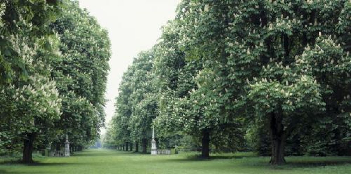
Coronation Avenue: Two Sphinxes flank the entrance to the avenue which was constructed in 1937 and extended in 1939. The avenue originally featured a double avenue of planes and chestnuts, the planes removed after storm damage sustained during the 1960s.
Cross Avenue: planted with planes and chestnuts with two 18th-century obelisks at the entrance, the avenue terminates at each end in a circle of trees; one of Birch, one of Lombardy poplars, and each contains a central vase.
Daffodil Walk: renamed to the Jubilee Walk in 1977 ornamented with statuary.
Emperors' Lawn: a broad walk which contains four bay-like openings each containing a bronze urn. The walk ends with a collection of busts of Roman emperors in a semi-circle of copper beech and temple of Doric columns constructed in 1951 which houses a Porphyry vase and statuary from between 1748-1763.
Lime Avenue: with views to the mill, the avenue is flanked by statues of Samson and Philistines by Van Nost.
Temple Lawn: created in 1953 with golden yews and a green yew hedge also contains 12 Corinthian columns with two lions flanking the entrance and a copy of 'David' by Bernini in the center of the lawn.
Wrestlers' Lawn: lawn with central focal point of a group of statues depicting wrestlers (presumably of the classical period).
The following is from the Register of Parks and Gardens of Special Historic Interest. For the most up-to-date Register entry, please visit the The National Heritage List for England (NHLE):
www.historicengland.org.uk/listing/the-list/
Mid-20th century gardens and grounds, with a notable collection of historic statuary, laid out by the owner, Lord Fairhaven, between 1926 and 1966.
DESCRIPTION
LOCATION, AREA, BOUNDARIES, LANDFORM, SETTING
Anglesey Abbey is located at Lode, c 9km north-east of Cambridge on the north side of the B1102 Cambridge to Bottisham road. The c 40ha level site lies surrounded by the flat, open Cambridgeshire fenland landscape, enclosed from it on all sides by dense perimeter plantations. The south-east boundary is formed by the B1102, while the Bottisham Lode bounds the site to the north-west. Farmland lies to west and east, the village of Lode lying off the northern tip of the gardens.
ENTRANCES AND APPROACHES
The main entrance to Anglesey Abbey lies at the east end of the B1102, past a mid C19 cottage-style lodge built of stone with mullioned windows under a tile roof. The yew-hedged entrance leads to a set of stone gate piers surmounted by carved lions and hung with iron gates (listed grade II), which are set well back from the road. They are of early C19 date, moved here in 1926 from the Port of London Admiralty entrance. The drive runs north-north-west then turns north-west through the Arboretum to reach the east front of the Abbey. A second entrance, in the centre of the B1102 boundary, leads onto a straight drive running north parallel to the Jubilee Avenue. It turns east close to the north-west boundary and leads into the service courtyard. This drive is the older of the two, being shown on the 1817 OS map, while the lodged entrance is first recorded on the 1886 OS map. A late C20 pedestrian route has been added from the National Trust car park on the eastern boundary, running through the Pinetum to join the main drive as it passes through the Arboretum.
PRINCIPAL BUILDING
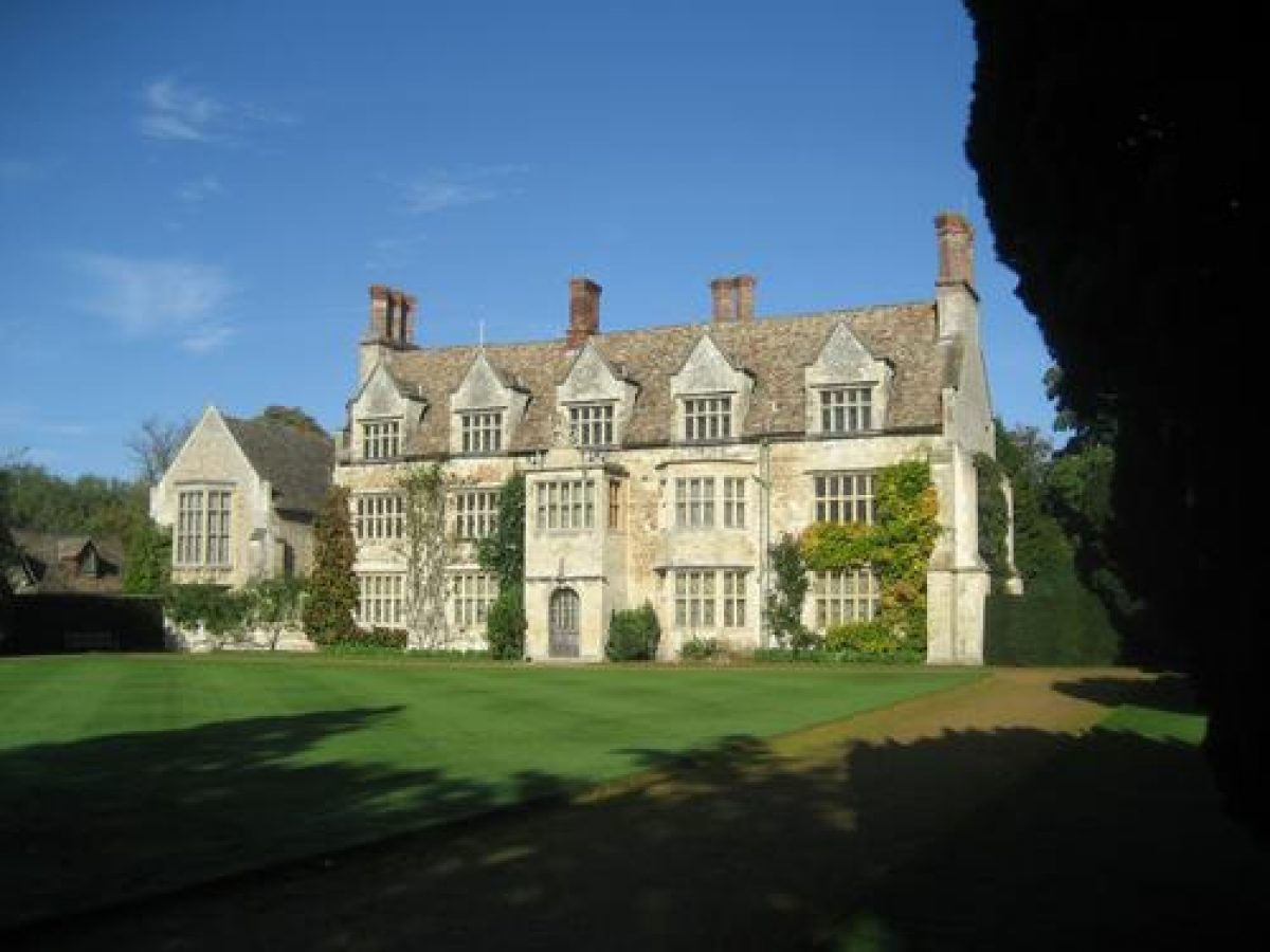
Anglesey Abbey (listed grade I) is a country house built of limestone and clunch under a steeply pitched tiled roof, laid out in two main ranges each of which forms a T-plan. The Abbey is built in two storeys with attics, the main south front having five bays which look out across the pleasure grounds. The east and south ranges incorporate the remains of the C13 priory which was converted into a private house by the Fowkes family in the early C17 and it is from this period that the Abbey retains its character. The house was further enlarged during the mid C19 by Rev John Hailstone and altered again in the C20, partly by Sir Albert Richardson for the first Lord Fairhaven. Immediately to the north-west of the Abbey lies an early C16 timber-framed barn (listed grade II) which has been converted (late C20) to domestic use and offices.
A mid C19 stone and tile service courtyard and stable block lies c 100m to the north-west of the Abbey, its four wings enclosing a central court, with extensions north from the west wing and south from the east wing.
GARDENS AND PLEASURE GROUNDS
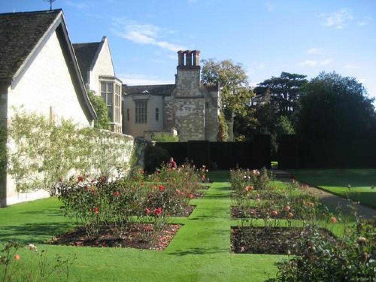
The main areas of enclosed gardens lie to the north and south-west of the Abbey. The north front looks onto the Monks Garden, which is laid to grass planted with spring bulbs and fruit trees. Beyond its north boundary, c 80m north of the Abbey, lies the Dahlia Garden enclosed by curved beech hedges, to the north-east of which is the beech-enclosed semicircular Herbaceous Garden, laid out in its present form, along with the Dahlia Garden in 1952. A path from the southern end of this compartment leads back along the east front of the Abbey and round to the south front which looks over a formal square of lawn. Beyond this to the east is the enclosed Rose Garden. Laid out with a series of simple rectangular beds, it was already in existence when Lord Fairhaven purchased the property in 1926 but was subsequently completely replanted by him. A path running along the southern boundary of the Rose Garden leads west to the Formal Garden, a polygonal enclosure of yew c 100m south-west of the Abbey, planted with seasonal bedding. On the west side of the Formal Garden boundary hedge is the Narcissus Garden where formal borders flanking a statue of Narcissus look west over the pleasure grounds.
The gardens and pleasure grounds are filled with a nationally important collection of historical statuary, the pieces forming elements in the layout of many of the garden spaces and giving focus to the walks and vistas in the pleasure groundS. The collection was put together by Lord Fairhaven to decorate his garden compartments (the majority listed grade II) (see RCHM(E) 1972 and Guidebook 1997 for descriptions and details).
Together the gardens and pleasure grounds cover c 40ha, the pleasure grounds laid out in a complex series of walks and cross-walks, avenues and vistas, all punctuated by Lord Fairhaven's statuary collection. From the National Trust visitors' car park on the eastern boundary the path leads through the Pinetum in the south-east corner of the site and from there north to the Fairhaven Centenary Walk, a late C20 feature added by the Trust along the eastern boundary. On a north/south axis, parallel to this and divided from it by a beech hedge, is the Emperor's Walk, between avenues of spruce and yew with a central Temple of Doric columns surrounded by a semicircular beech hedge. The south and north ends are terminated by statuary, the Olympian Walk and Holm Oak Avenue lying beyond the Walk to the north. The Warrior's Walk runs parallel to the Emperor's Walk and beyond this to the west is the Arboretum, Spring Garden and Bishop's Walk, which together complete the pleasure ground areas to the east of the Abbey. The Arboretum lies at the southern end of a lime avenue planted in 1937, the northern end of which is focused on Quarry Pool, which lies c 250m north of the Abbey. The pool was created by flooding a disused C19 site of coprolite extraction. A vista across the water from the end of the lime avenue is focused on Lode Mill at the head of the river at the northernmost point of the grounds, c 360m north-north-east of the Abbey. The Mill dates from the mid C18. From here a riverside path runs alongside the Lode and links back to the Herbaceous Garden on the north side of the Abbey.
PARK
Beyond the formal lawn on the south front lies the South Glade, comprising lawns backed by trees and shrubs. Some of the character of the Rev Hailstone's Victorian planting survives here, as does the substantial earthwork remains of the priory drains and fishponds. Between the South Glade and the B1102 boundary is the South Park, an area of open grass scattered with mature trees, some of which are of mid C19 origin. The Bottisham and Lode Enclosure map of 1808 shows this area to be 'old enclosures' but by 1817 the OS Surveyor records that the South Park had been created (OS 1817). The South Glade and South Park are bordered to the west by the Jubilee Avenue, laid out on a north/south axis beside the back drive. Originally planted in the 1930s with elms and known as the Daffodil Walk, the avenue was replanted with hornbeam in 1977 following losses as a result of Dutch elm disease.
The land to the west of the drive is divided in half by a double row of horse chestnuts known as the Coronation Avenue which runs east/west up to the western boundary of the site, framing a view west over the surrounding farmland. The avenue was planted with horse chestnut and London plane in 1937 to mark the coronation of George VI but storm damage in 1968 removed most of the planes, leaving only the chestnuts. The areas to the north and south of the avenue are filled with specimen trees and are known as The Squares. Between the north Square and the north-west boundary plantation is the Temple Lawn, laid out in 1953 to celebrate the coronation of Elizabeth II with three island plantings in grass surrounded by deep belts of trees. The Pilgrim's Lawn lies between the south Square and the south-east boundary. Like the Temple Lawn it is laid to grass enclosed by deep belts of trees and planted with island beds. These were the last of Lord Fairhaven's plantings put in shortly before his death in 1966.
Running parallel to the western boundary of the site, at right angles to the Coronation Avenue and planted at the same time as it, is the Cross Avenue of horse chestnuts. It is terminated at one end by a circle of fastigiate beech and at the other end by a circle of silver birch. The small extension of the Coronation Avenue which takes it over the Cross Avenue out to the boundary was planted in 1939. The whole of the area to the west of Jubilee Walk was farmland until the 1930s when Lord Fairhaven began to extend the grounds.
REFERENCES
Country Life, 115 (18 March 1954), pp 770-3; (25 March 1954), pp 860-3
L Roper, Gardens of Anglesey Abbey (1964)
N Pevsner, The Buildings of England: Cambridgeshire (1970), pp 291-2
Roy Comm Hist Monuments Engl: North-east Cambridgeshire (1972), pp 74-80, pls 118-20
G S Thomas, Gardens of the National Trust (1979), pp 93-5
J Kenworthy-Browne et al, Burke's and Savills Guide to Country Houses III, (1981) pp 3-4
Anglesey Abbey Garden, guidebook, (National Trust 1997)
Maps
Enclosure map of Bottisham and Lode, 1808 (Cambridgeshire Record Office)
OS Surveyor's drawings, 1817 (British Library Maps)
OS 6" to 1 mile:
1st edition published 1886
2nd edition published 1903
3rd edition published 1926
OS 25" to 1 mile:
1st edition published 1886
2nd edition published 1901
Archival items
Sale particulars of Anglesey Abbey, 1926 (1026/SP227), (Cambridgeshire Record Office)
Description written: June 2000, Amended: December 2000
Register Inspector: EMP
Edited: January 2001
- Visitor Access, Directions & Contacts
Telephone
441223810080Access contact details
The site is open all year.
- History
The following is from the Register of Parks and Gardens of Special Historic Interest. For the most up-to-date Register entry, please visit the The National Heritage List for England (NHLE):
www.historicengland.org.uk/listing/the-list/
HISTORIC DEVELOPMENT
A priory of Augustinian canons was founded at Anglesey by Henry II. The remains of their early 13th century building survive within the present fabric and earthworks in the garden mark the position of fishponds and drains. The priory was dissolved in 1536 and three years later was granted to John Hynde of Madingley, upon whose death in 1550 it passed to Sir Francis Hynde. When Sir Francis died in 1595 the site came into the ownership of the Fowkes family, who converted what remained of the priory into a house. This subsequently passed through a number of owners, including the Cambridge carrier Thomas Hobson, his son-in-law Thomas Parker, Sir George Downing, Jacob Whittingham, the Reverend George Jenyns and the Reverend John Hailstone. It was Reverend Hailstone who, in the 1860s, added a service wing on the west side of the house and remodelled the small gardens and pleasure grounds, which had been created by the beginning of the 19th century (Ordnance Survey 1817). The house was put up for sale in 1926 and was purchased by Huttleston Broughton, first Lord Fairhaven. Anglesey became his principal residence in 1930 and from that time on he began to alter the house and to develop and greatly extend the gardens. On his death in 1966 Lord Fairhaven left Anglesey Abbey and its extensive grounds to the National Trust, who have conserved his gardens and in whose hands it remains (2000).
Period
- 20th Century (1901 to 2000)
- Early 20th Century (1901 to 1932)
- Associated People
- Features & Designations
Designations
The National Heritage List for England: Register of Parks and Gardens
- Reference: GD1601
- Grade: II*
Features
- Sundial
- Description: The sundial, attributed to Cox, dates from 1788, and was brought to the site by Lord Fairhaven in the late-1920s.
- Earliest Date:
- Latest Date:
- Pool
- Statue
- Description: The garden features a large collection of statuary collected by Lord Fairhaven between 1926 and 1966, described in detail in 'detailed description'.
- Earliest Date:
- Latest Date:
- House (featured building)
- Description: The remains of the 13th-century priory were converted into a house in around 1600.
- Earliest Date:
- Latest Date:
- Rose Garden
- Description: The Rose garden features simple rectangular beds.
- Avenue
- Description: From the rose garden is a double avenue of alternating crab apples and cherries crossed by another avenue of the same trees with a Rond-point leading to the hyacinth garden.
- Planting
- Description: The Dahlia garden is enclosed by curving beech hedges, backed by Lombardy Poplars and features a variety of garden ornaments including one of `Time' attributed to Rysbrack.
- Tree Feature
- Description: An arboretum leads from the side of the house leads to the Quarry Pool.
- Key Information
Type
Garden
Purpose
Ornamental
Principal Building
Domestic / Residential
Period
20th Century (1901 to 2000)
Survival
Extant
Hectares
47
Open to the public
Yes
Civil Parish
Lode
- References
References
- {English Heritage Register of Parks and Gardens of Special Historic Interest} (Swindon: English Heritage 2008) [on CD-ROM] Historic England Register of Parks and Gardens of Special Historic Interest
- Thomas, G S {Gardens of the National Trust} (1979) pp 93-95 Gardens of the National Trust (1979)
- Pevsner, N {The Buildings of England: Cambridgeshire} (Harmondsworth: Penguin, 1970) pp 291-292 The Buildings of England: Cambridgeshire
- Historic Land Management {Anglesey Abbey Conservation Management Plan} (2012) Anglesey Abbey Conservation Management Plan
Contributors
Cambridgeshire Gardens Trust