Introduction
Addington Palace has the remains of an 18th-century landscape park and woodland. The grounds covered 200 hectares at their most extensive, but are now in divided use and ownership.
Terrain
The site is undulating and slopes down generally from the north-west to the south-eastwww.historicengland.org.uk/listing/the-list/
Remains of an C18 park surrounding an C18 mansion. The grounds were landscaped by Lancelot Brown, and later, in the C19, the property became the summer home of the archbishops of Canterbury.
DESCRIPTION
LOCATION, AREA, BOUNDARIES, LANDFORM, SETTING
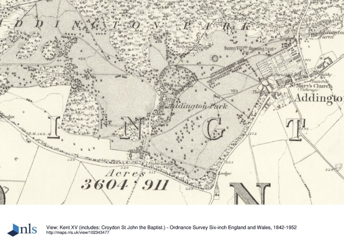
Addington Palace lies to the south-east of the London Borough of Croydon, between the settlements of Addington, Shirley, and Forestdale. The mid C20 development of New Addington lies to the east, separated from the site by the A 2022, Kent Gate Way and agricultural land.
The 120ha site is bounded on the north-east by Shirley Church Road, on the south-east by Kent Gate Way, on the south-west by Gravel Hill, and on the north by the private road, Birch Hill, some playing fields, and Pinewood Close. Bishops Walk with its prestigious residential developments enters the site off Shirley Oaks Road to the west.
The ground at Addington Palace is undulating and slopes down generally from the north-west to the south-east, forming part of a dry valley with a ridge of high ground c 400m to the north of the Palace. The view to the east is marred by the high-rise buildings of New Addington. The vegetation to the north is typical of Surrey heathland whereas to the south parkland trees thrive.
ENTRANCES AND APPROACHES
The main entrance to the site (1998) is off Gravel Hill, 300m to the south of the mansion, past the C19 Stable Lodge (Plantation Lodge on 1842 Addington Manor Tithe map) and the stables (first shown on the Addington Tithe map, 1837), now the offices of Addington Palace Golf Club. The drive, which terminates at the forecourt of the mansion, was, before the storms of 1987 and 1990, lined with mature trees; some replanting has been undertaken since. This entrance replaces others shown on Driver's map, including the drive from the west along Bishops Walk which is now a private road and the demolished C19 lodge, and one from the east where the access from Spout Hill is marked by the Lion Lodges (C18, listed grade II) built, like the house, by Robert Mylne. A spur from this drive was later (C19) directed through the walled garden as a short cut to the neighbouring parish church. Driver also shows a third track which runs from the south-east boundary (Kent Gate Way) to link up with the Lion Lodges drive to the north-east of the mansion. A fourth entrance, the South Drive, which entered the grounds to the north-east of the junction of Gravel Hill and Kent Gate Way and was first shown on the 1837 Tithe map, most probably dates from 1828 when the South Lodge was built by Archbishop Howley. The latter two drives survive as distinctive linear features now grassed over.
PRINCIPAL BUILDING
The construction of Addington Palace (listed grade II*), or Addington Place as it was originally called, was started in 1772 when Barlow Trecothick commissioned the London-based architect Robert Mylne to design a new house on a site some distance to the south-west of the earlier house. A chapel, library, and other apartments were added by Henry Harrison in 1829-30 and the building was further extended by Norman Shaw for Frederick English, the owner between 1889 and 1909. The Royal School of Church Music leased the mansion from Croydon Council between 1951 and 1996.
GARDENS AND PLEASURE GROUNDS
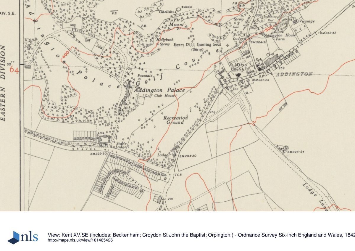
The area of the pleasure grounds to the east of the mansion was created under the direction of successive archbishops of Canterbury and replaced part of the C18 parkland shown on Driver's plan of 1802 and illustrated in the Balwin and Hogg engravings of 1762. The extent and layout of the pleasure grounds are shown in some detail on the OS 1st edition 25" map (1867). The pleasure grounds occupy a relatively level rectangular grassed terrace which can be approached from inside the mansion or through a small iron gate in the C19 boundary wall, 40m to the south of the mansion. The terrace is bounded to the west by the mansion, the tall C18 garden wall, and the C19 wall added when the pleasure grounds were made. A belt of trees, scrub, and shrubs to the south screen the pleasure grounds from the drive and the stables. To the east the terrace is contained by a low C19 brick wall (Tithe map, 1842) 120m long and rendered to give the impression of stone. It is capped with stone and the piers of a centrally placed opening (post 1868 OS) are topped with artificial stone urns. The recessed seat shown on the OS map of 1867 does not survive but debris strewn on the east side of the terrace wall may be remnants of the structure. To the north the boundary of the terrace is marked by a pronounced bank and a grassed-over path. A photograph in the 1911 sale catalogue shows that the bank was surmounted with iron railings. At the junction of the bank and the terrace wall there is a narrow flight of five steps down into the park; the piers at the top of the steps no longer support the urns recorded in 1911 (sale catalogue). The terrace is dominated by a huge cedar of Lebanon which is thought to be one of the specimen trees associated with the period of Lancelot Brown's involvement at Addington Place. The lower branches of the cedar today (1998) spread across most of the width of the terrace and are propped up with wooden stakes.
The paths shown on the 1st and 2nd editions of the OS map do not survive but the route from the gate in the west wall around the east side of the grass to steps in the north-east corner can be traced as a depression in the ground and the overgrown yews to the south are probably remnants of hedges of that period. Beyond the northern boundary of the terrace the ground slopes down to the north and 40m to the north of the bank, on the site marked 'fountain' on the OS 1st edition map, is a refurbished fountain. Beyond the fountain the ground rises to the north where the twelfth hole of the Addington Palace Golf Course encroaches on the remains of the roughly circular C19 arboretum arranged around the shallow valley.
PARK
The parkland is now occupied (1998) by two golf courses, the Addington Palace Golf Club and Addington Golf Club, and Addington Park, a public open space used for sports and recreational activities.
Addington Park forms a roughly rectangular area (c 12ha) of mown grassland south-east of the mansion. Along the south-east boundary is the A2022 and to the north-west the ground rises towards the mansion and gardens. To the north-east the park bounds Addington village. Besides the remains of Brown's boundary planting along Gravel Hill and the A2022, a number of mature parkland trees survive, including two large, free-standing beech trees in the southern part of the park, thought to be late C18, and the remains of a circular clump of horse chestnuts first shown on the 1898 edition of the OS map. The two extinct drives mentioned above survive only as earthwork features now grassed over, but the south lodge survives.
The boundary between Addington Park and Addington Palace Golf Club is marked by a line of trees, some of which appear on the OS map of 1867, and scrub; views to the mansion from the east are restricted.
The effect on the parkland of the golf courses can be seen by reference to the 1934 edition of the OS map; it is evident from this that many trees, including much of the C19 arboretum to the north of the mansion, were removed to accommodate the courses. Much of the centre of the park was lost when plots of land were sold for low-density housing development c 1930. At the same time the south drive was abandoned and the principal access to Addington Palace and the Addington Palace Golf Club became the entrance off Gravel Hill directly to the south of the Palace.
The 107ha now managed by the two golf clubs is described on Driver's plan as parkland with trees, heath, and wood; few individual trees are shown except for the geometric plantings either side of the Lion Lodges drive to the east. Although many of the bunkers and tees are intrusive the site retains its parkland aspect with clumps of mature trees; Primrose Hill, which is shown on Driver's plan, still remains as a focal point to the north-west from the mansion.
To the extreme north of the site an entrance marked by the C19 Swiss Lodge leads past Swan Pond. The path leads through a now (1998) overgrown collection of rhododendrons planted by Archbishop Howley, who is thought to have relandscaped the whole of the northern area in the mid C19. The overgrown remains of the Pinetum, planted to the north-east of the estate by Archbishop Manners Sutton in 1809, hides the monument he erected to celebrate the Golden Jubilee of George III.
From a high point to the north of the site are fine views south back to the mansion and the surrounding countryside.
KITCHEN GARDEN
The site of the walled kitchen garden, 0.5km to the north-east of the mansion, was used for residential development c 1970 and is not included in the area here registered.
REFERENCES
E Walford, London Old and New (nd), p 133
W Watts, Seats... (1779), pl 19
G A Walpoole, New British Traveller (1784), p 56
W Thornton, New Complete and Universal History (1786), p 506
J P Neale, Views of the Seats ... (1818-23)
G F Prosser, Select Illustrations of Surrey (1828)
J C Loudon, Encyclopedia of Gardening (1829)
Gardeners' Chronicle, i (1902)
D Stroud, Capability Brown (1974), p 214
B Cherry and N Pevsner, The Buildings of England: London 2 South (1983), pp 204-5
F Shorrocks, guidebook, Addington Palace History and Description (nd), pp 23-5
Outline Restoration Plan for Addington Palace Golf Course, (Colson Stone 1991)
Addington Palace and Addington Palace Gardens Restoration Management Plan, (Colson Stone 1996)
Maps
John Rocque,Topographical Survey of the County of Surrey, 1762
A P Driver, Addington Park,1802 (reproduced in Colson Stone 1996)
Tithe map for Addington Manor, 1837 (Croydon Local Studies Centre)
Tithe map for Addington parish, 1842 (reproduced in Colson Stone 1996)
OS 6" to 1 mile:
1st edition surveyed 1867, published 1868
2nd edition published 1898
3rd edition published 1912, 1930 edition
OS 25" to 1 mile:
1st edition published 1867
2nd edition published 1898
Illustrations
R Balwin and A Hogg, engraving, East Front of the House, 1762 (reproduced in Colson Stone 1996) [Shows the house before the terrace was made.]
W Watts, engraving, Addington Place, in Surrey, the seat of James Ivers Trecothick Esq, 1779 (reproduced in Colson Stone 1996) [Front of the house from the north-west.]
Archival items
Photograph, Church Walk (Sale catalogue, 1911), (Croydon Local Studies Centre)
Photograph, Addington Palace Estate (Sale catalogue, 1911) [View of a small part of the pleasure grounds from the north-east with east boundary fence.]
Description written: May 1998
Amended: November 2001
Register Inspector: LCH
Edited: November 2001
- Visitor Access, Directions & Contacts
Access contact details
There are occasional open days throughout the year. See http://www.addington-palace.co.uk/events/addington-palace-open-days.html for details.
Directions
http://www.addington-palace.co.uk/find-addington-palace.html
Owners
Westmead Business Group
Airport House, Purley Way, Croydon, Surrey,, CRO OXZ
- History
The following is from the Register of Parks and Gardens of Special Historic Interest. For the most up-to-date Register entry, please visit the The National Heritage List for England (NHLE):
www.historicengland.org.uk/listing/the-list/
HISTORIC DEVELOPMENT
Originally part of the manor of Addington with records dating back to the Saxon period, the property was recorded in the Domesday Survey of 1086 and was later (1509-47) owned by Henry VIII and used as a hunting park. Between 1544 and 1768 the manor was owned by the Leigh family until it was purchased by Alderman Barlow Trecothick in 1768. Construction of a new house started in 1772 but was not completed until 1780, five years after the death of Barlow Trecothick. In 1781 Barlow's nephew, James Ivers Trecothick, commissioned Lancelot Brown (1716-83) to design a parkland setting for the new house. Details of Brown's work are unclear but A P Driver's plan of 1802 is thought to give an idea of the scope of Brown's work. Driver's plan does not include individual details of the many parkland trees, but instead describes areas as 'Parkland with trees'.
In 1807 the site was purchased by the Church of England and the name of the house was changed from Addington Place to Addington Palace in keeping with its new status as a summer residence for the archbishop of Canterbury. Under the influence of successive archbishops the layout of the grounds underwent further development and refinement and by 1829 a terrace garden to the east of the house had been created (Loudon 1829) and a Rhododendron Walk from a Swiss Lodge to the north (Shorrucks nd).
In 1898 the Church of England sold the house and land to Frederick Alexander English who extended the house, and also the gardens to the east of the house. After the death of English in 1909 the estate was spilt up, part being sold to the Addington Golf Club and part to a group of businessmen who formed the Addington Palace Golf Club. The remainder was sold for residential development. In 1930 an area to the south, now known as Addington Park, was sold to Croydon Corporation to be used as a public park.
It is evident from the 1934 edition of the OS 6" map that many trees were removed during construction of the golf courses, and housing had by then started to encroach into the park. In 1951 the freehold of the mansion and the Addington Palace Golf Club was sold to the Corporation of Croydon and between 1951 and 1996 the mansion was leased to the Royal School of Church Music. The site is currently (2001) leased to a private company who are developing the house and grounds for greater public use.
Period
18th Century (1701 to 1800)
- Associated People
- Features & Designations
Designations
The National Heritage List for England: Register of Parks and Gardens
- Reference: GD1783
- Grade: II
Green Belt
Features
- Mansion House (featured building)
- Description: The house was completed either in 1778 or in 1780. Further alterations have been carried out since then.
- Earliest Date:
- Latest Date:
- Key Information
Type
Park
Purpose
Ornamental
Principal Building
Commercial
Period
18th Century (1701 to 1800)
Survival
Extant
Hectares
120
Open to the public
Yes
- References
References
- Stroud, D {Capability Brown} (1974) p 214 Capability Brown (Country Life article)
- {English Heritage Register of Parks and Gardens of Special Historic Interest} (Swindon: English Heritage 2008) [on CD-ROM] Historic England Register of Parks and Gardens of Special Historic Interest
- Cherry, B. and Pevsner, N. {The Buildings of England: London 2: South} (Harmondsworth: Penguin, 1983) pp 204-205 The Buildings of England: London 2: South
Contributors
London Parks and Gardens Trust
- Related Documents
-
CLS 1/355/1
Addington Palace Outline Restoration Plan (Feb.) - Hard copy
Colson Stone Partnership - 1992
-
CLS 1/355/2
Draft Historic Landscape Survey and Restoration Management Plan (May) - Hard copy
Colson Stone Partnership - 1996
-
CLS 1/356
Historic Landscape Survey and Restoration Management Plan (June) - Digital copy
Colson Stone Partnership - 1996
-
CLS 1/355/1