Introduction
Features of the park include wide avenues lined with specimen trees, lakes with islands, tree clumps and a water garden.
Terrain
The landform in the park varies but is markedly more undulating than the surrounding landscape, with a general fall from north to south.
Owners of Wimpole have always noted the topographical junction of the flat clay lands to the west of Cambridge wth the rising chalk ground which can be traced south-west to the Chilterns. From the Hall each vista is distinct. To the south the land opens out towards the hills beyond Royston, but to the north and east the land rises into undulating wooded hills. Around the Hall there is parkland dotted with trees, with farmland and woods beyond.
The earliest reference to the park is indicated on a 1638 estate map showing two deer parks to the west of the old manor house, the High and Low Park, marked by banks which still survive, as do some of the walnut trees which separated them. Sir Thomas Chicheley replaced the manor house in 1640 with a new mansion and formal garden. A formal avenue 90 feet wide was planted south towards the road.
The Earl of Radnor acquired Wimpole in 1683 and Kip’s engraving shows the extensive improvements to the garden which were carried out. A water garden was laid out to the south-west of the Hall and ponds to the south-east. To the north, fish ponds were added with clumps of trees to the north. Johnson’s Hill, the high point to the north was linked to the Hall by a new avenue.
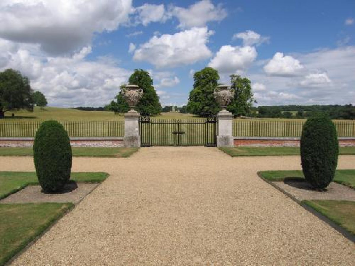
Between 1720 and 1725, Lord Harley employed Charles Bridgeman, who added more avenues in the parkland and simplified Radnor’s north garden. He planted a grid of limes and horse chestnuts to the west of the Hall, and by cutting through another avenue allowed Whaddon church spire to become an eye catcher. Bridgeman’s most dramatic alteration was the two mile long South Avenue, with parallel lines of elms 50 feet apart across a space of 90 yards. The avenue continues around an octagonal basin and then to the Great North Road. The avenue was felled in the 1970s following Dutch Elm Disease, and has been replanted with limes grafted from the trees on the estate.
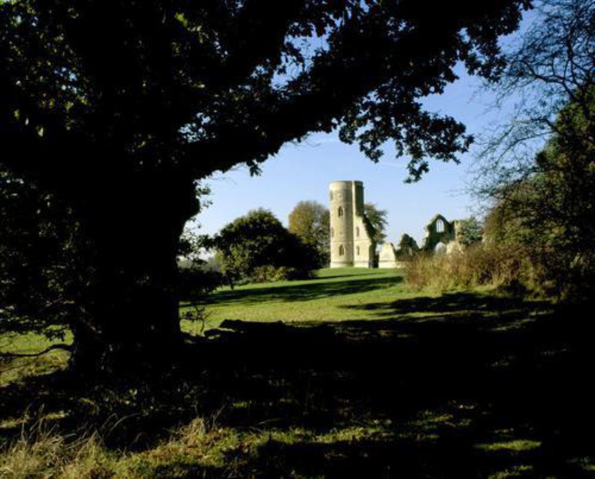
‘Capability’ Brown proposed alterations to the formal avenues between 1765 and 1775, mainly those to the north-west of the hall. Radnor’s fish ponds became lakes with islands and were crossed by a Chinese bridge, which has now been restored. In 1774 James Essex reworked Sanderson Miller’s proposals for a Gothic tower on Johnson’s Hill, which consists of three circular towers in various stages of ruin. 15 years later, Brown’s pupil William Emes relocated the kitchen garden to its present position and the park was extended further to the south-west, where new plantations sheltered it from the road.
In 1801 Humphry Repton proposed further informality in the planting by extending and bulking up Brown’s belts of trees around the perimeter of the park. He laid out the drive to the east via Cobb’s Wood and then looping to the south to the Cambridge Road near Orwell. The west gates to the park at the village of Arrington and the stables were designed in 1851 by Kendall. The park was extended in the mid-19th century and planting continued until 1910.
Since the estate was given to the National Trust, a considerable amount of new planting and restoration work in the park has been undertaken and a series of planned walks have been established. Rare breeds of animals now graze the fields of the park.
- Visitor Access, Directions & Contacts
Telephone
0844 800 1895Website
http://www.nationaltrust.org.ukDirections
Owners
The National Trust
Heelis, Kemble Drive, Swindon, SN2 2NA
- History
Wimpole Hall, a magnificent building, stands in eight hectares (20 acres) of garden and 200 hectares (500 acres) of formal and landscaped park, with walled gardens and an estate farm. The property is now owned by the National Trust. The park dates from 1302 and the Hall was built in the mid-17th century, with alterations by Gibbs, Flitcroft, Soane and Kendall.
- Associated People
- Features & Designations
Features
- Island
- Earliest Date:
- Latest Date:
- Clump
- Earliest Date:
- Latest Date:
- Hall (featured building)
- Earliest Date:
- Latest Date:
- Ha-ha
- Description: A second serpentine ha-ha (partly by Brown, partly mid 19th century) crosses the north park about 250 metres north of the Hall.
- Lake
- Description: A string of serpentine lakes, created by Brown out of Lord Radnor's late-17th century fishponds.
- Ornamental Bridge
- Description: A wooden Chinese Bridge (of late-18th century design, rebuilt in the late 1970s).
- Folly
- Description: Gothic-style Folly Castle, built under Brown's supervision by James Essex.
- Earliest Date:
- Latest Date:
- Avenue
- Description: A short length of lime and chestnut avenue, a surviving portion of Radnor's north avenue altered and thickened by later planting.
- Avenue
- Description: Charles Bridgeman's great double South Avenue which runs from the drive south of the Hall for more than 4 kilometres across the park and out over the surrounding farmed landscape.
- Basin
- Description: Towards the end of the South Avenue is an octagonal basin.
- Avenue
- Description: The South Park also contains a Walnut avenue which survives from the 1690s.
- Earliest Date:
- Latest Date:
- Tree Belt
- Description: Many of the enclosing belts of trees in both the North and South Park have survived.
- Avenue
- Description: The recently replanted west avenue (1980s) replaced an elm avenue lost in the 1970s.
- Earliest Date:
- Latest Date:
- Key Information
Type
Park
Purpose
Ornamental
Survival
Extant
Hectares
208
Open to the public
Yes
Civil Parish
Wimpole
- References
Contributors
Cambridgeshire Gardens Trust
- Related Documents
-
CLS 1/1203
A Survey of the Landscape
John Phibbs - 1979
-
CLS 1/1204
Wimpole Park, Cambridgeshire - Survey
John Phibbs - 1980
-
CLS 1/1205
English Heritage - 2001
-
CLS 1/275/1
Conservation Plan - Digital copy
Colvin and Moggridge - 2006
-
CLS 1/1040
Gervase Jackson-Stops - 1979
-
CLS 1/1203