Introduction
Shugborough has mid-18th-century pleasure grounds, landscape park and walled garden. There are some notable garden buildings by James Stuart and John Webb. There is a formal garden designed by William Andrews Nesfield in about 1855.
Terrain
The highest ground lies to the west, where Stafford Plantation occupies the lower slopes of the Satnall Hills.
The following is from the Register of Parks and Gardens of Special Historic Interest. For the most up-to-date Register entry, please visit the The National Heritage List for England (NHLE):
www.historicengland.org.uk/listing/the-list
A pleasure ground and landscape park of the mid to late C18 with buildings in the Chinese and Greek Revival styles, associated with a country house. The formal garden layout by W A Nesfield dates from c 1855.
DESCRIPTION
LOCATION, AREA, BOUNDARIES, LANDFORM, SETTING
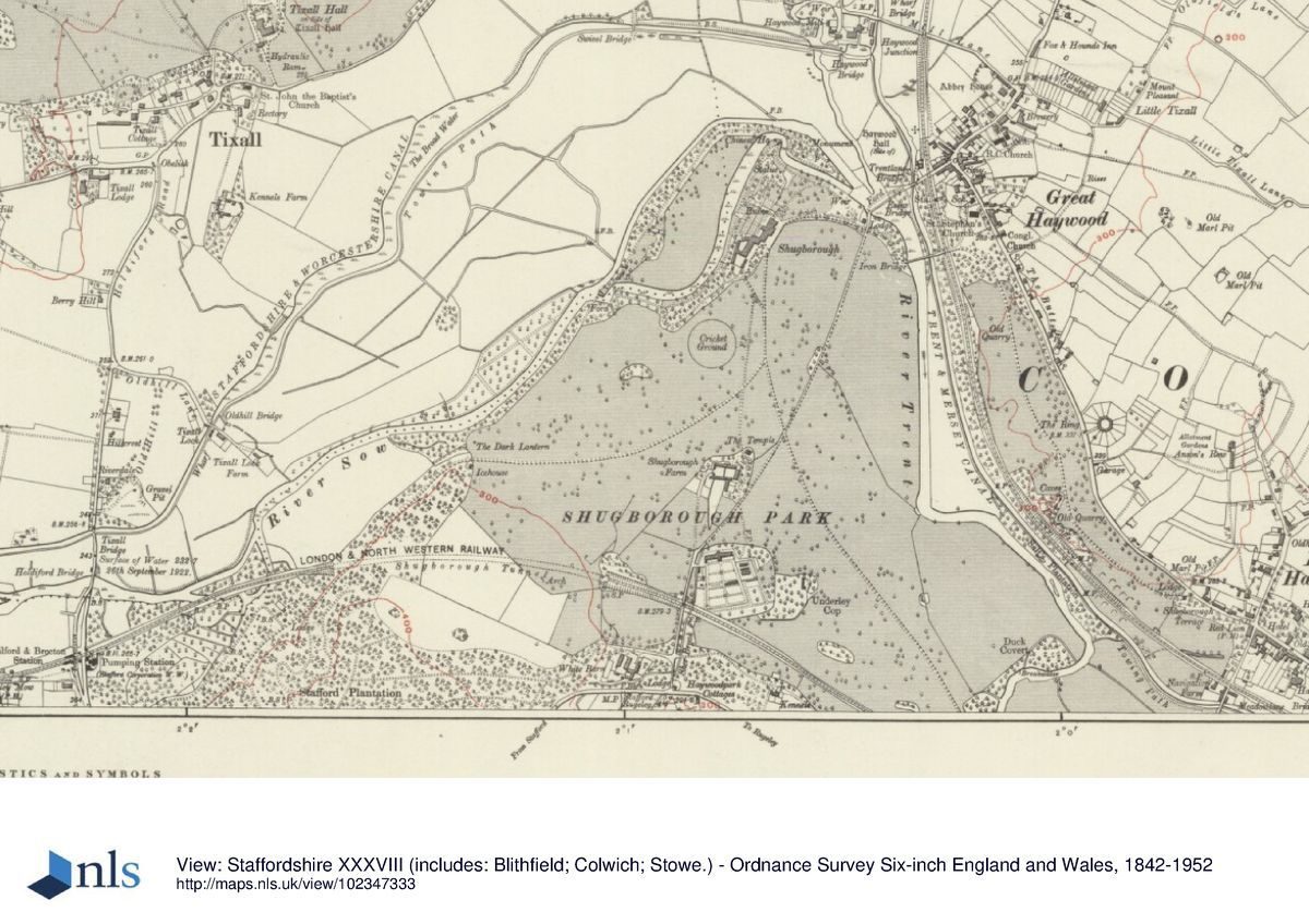
Shugborough lies c 6km east of Stafford, and the park is partly bounded to the south by the A513 from Stafford to Rugeley. To the north-east the park is separated from the village of Great Haywood by the A51. The boundary along Shugborough's north-west side is formed by the River Sow. At the northernmost point of the park this joins with the Trent, which passes through the east side of the park and for c 1km forms its boundary. The highest ground lies to the west, where Stafford Plantation occupies the lower slopes of the Satnall Hills.
ENTRANCES AND APPROACHES
The Stafford Lodge (listed grade II) stands east of Milford on the south-west corner of the park. Comprising twin cubic lodges with Tuscan columns in antis flanking recessed centres, it was built to a design by Samuel Wyatt to match the Lichfield Lodge, constructed almost twenty years earlier. From here the drive runs north-east along a terraced cut above the River Sow, passing Stafford Wood Lodge (listed grade II), an early C19 two-storey octagonal cottage with a hexagonal rear extension, designed by Samuel Wyatt.
The Lichfield Lodge (listed grade II) at the south-east corner of the park, also designed by Wyatt, was originally situated at Great Haywood. It was moved to this position when the London & North Western Railway drove its line north through the estate c 1847.
The Italianate Trent Lodge (listed grade II) was built 250m east of the Hall in 1859 as part of a gate complex where the drive from the Hall reaches the south end of Essex Bridge.
PRINCIPAL BUILDING
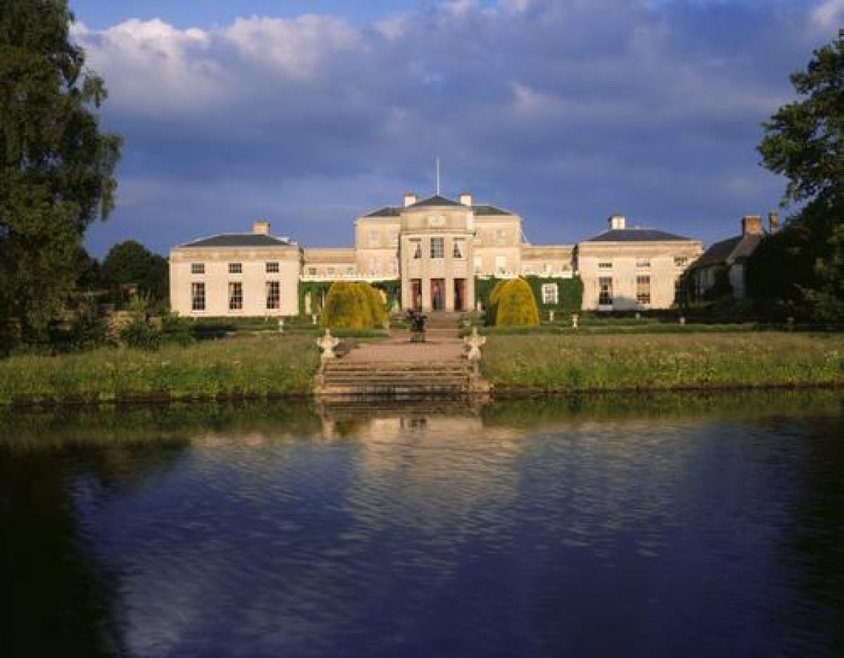
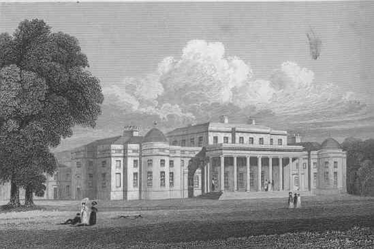
Shugborough Hall (listed grade I) comprises a central block, built c 1695 for William Anson, to which wings were added in 1748, probably by Thomas Wright (1711-86). About 1768 the single-storey links to the wings were raised, probably by James 'Athenian' Stuart (1713-88). In the 1790s the Hall was further enlarged and transformed, both inside and out, by Samuel Wyatt (1737-1807), who carried the cornice level of the wings across the east front of the Hall in the architrave of a new, octostyle, Ionic portico. At the same time the whole building was clad in slate, which was painted to resemble ashlar of mechanical smoothness and precision. Further alterations by Wyatt followed in 1803-6, with the creation of a large new saloon which projects from the centre of the west front. To the south of the Hall are extensive stables, service courts and ranges (listed grade II), much of the building being of c 1767.
An orangery was built to the north-west of the Hall, at right angles to the River Sow, in 1750. Reconstructed by Stuart in 1764 it was demolished c 1855.
GARDENS AND PLEASURE GROUNDS
To the east the Hall looks across Hall Field, defined by curving approach drives and laid to permanent pasture with a few specimen trees towards its eastern side.
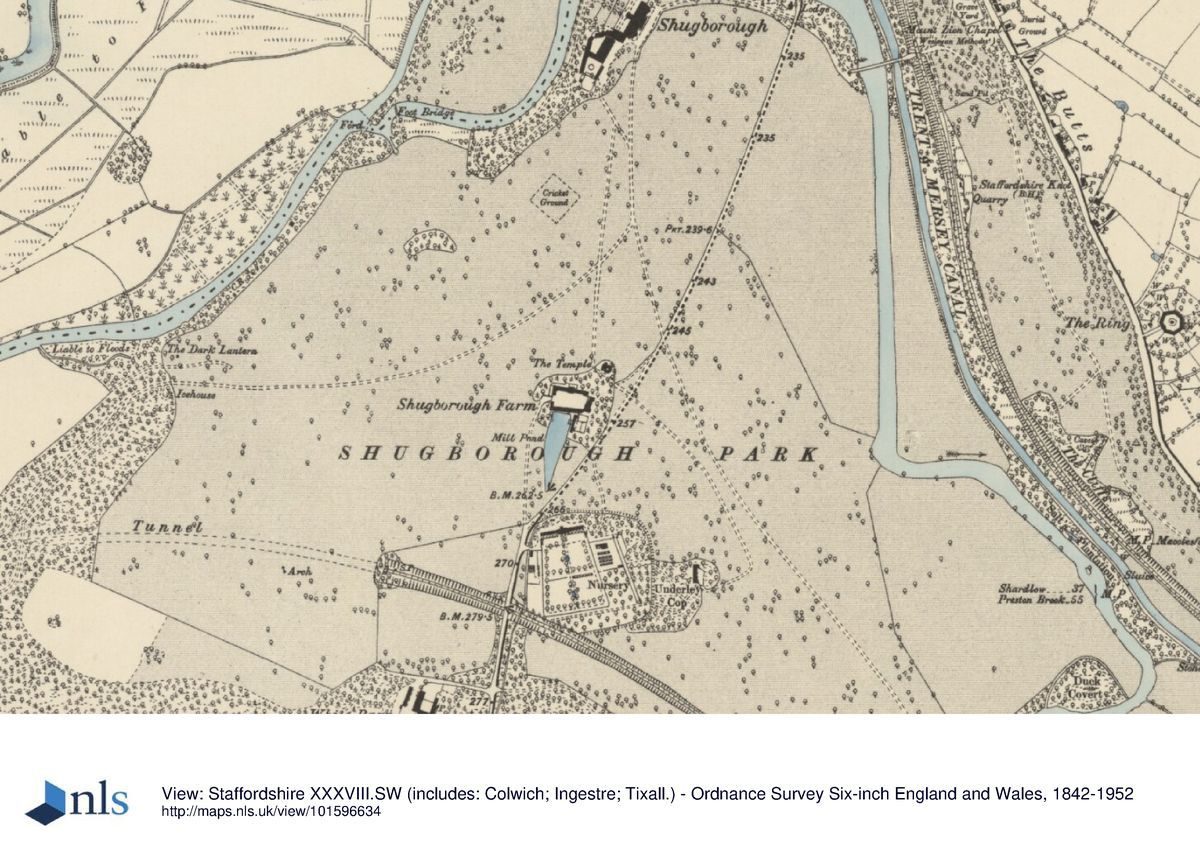
The main formal gardens lie west of the Hall and consist of a series of four low terraces laid to lawn with a central axial path, laid out c 1855 to a design by William Andrews Nesfield (1793-1881). Clipped golden yews (?early C20) line the axial path and a further path down the north side of the garden. A boy and swan fountain (listed grade II) stands towards the west end of the axial path, which ends with a short flight of stone steps down to the River Sow. In the C18 the area was a bowling green. To the north is a rose garden designed in the 1960s by Graham Stuart Thomas. This occupies the site of the Orangery demolished in the 1850s (see above).
To the south of the Hall is the Wild Garden, a C19 shrubbery with specimen trees which occupies the site of Thomas Anson's shrubbery. A walk from the Hall leads around the inside edge of the Wild Garden, giving glimpsed views of the park and its monuments. Beyond the south end of the garden is the cast-iron Blue Bridge (listed grade II), erected in 1813 by Charles Heywood. It leads across the River Sow to the arboretum, established in the C19 with Wellingtonias and other coniferous specimens and maintained in the later C20 by the fifth Earl of Lichfield who has built up a collection of oaks. From the bridge, a walk returns north along the side of the River Sow, giving views west to the lush meadow ground which lies between it and the New Cut made for the Sow c 1805.
The walk, with mature oaks and limes along its west side, then leads past the bottom of Nesfield's terraces. North of the steps to the river is The Ruin (listed grade II), designed at least in part by Thomas Wright c 1750. Incorporating architectural fragments said to derive from the bishops' house here, the monument includes a Coade stone druid seated on a crag. The whole was once more extensive, and included a gothick pigeon house. Originally it looked across the river to a classical colonnade that was probably among the features lost in the great flood of 1795.
North of The Ruins the walk becomes the North Walk. This leads to the Chinese House (listed grade I), completed in 1747 to a design based on a sketch made in Canton by one of Admiral Anson's officers. In the late C19 its chinoiserie contents were removed to the Hall for safe keeping. When built, the House and a boathouse stood on an island in an artificial canal which was reached by two Chinese bridges. After the flood of 1795 one arm of the canal was infilled, leaving the House on a promontory. It is approached from the east by the cast-iron Red Bridge of 1813 (listed grade I) by Charles Heywood.
Some 70m to the east of the Chinese House, on the island between the two arms of the Sow, is the Cat's Monument (listed grade II*). This takes the form of a square column on top of which is an urn surmounted by a cat. The animal commemorated is probably Thomas Anson's cat Kouli-Khun, a memorial to whom was being discussed in 1749. Below the vase are carved the heads of Corsican goats; they, like a Persian cat, were kept at Shugborough in 1768. The Cat's Monument stands c 100m north-east of the Shepherd's Monument and the two were presumably intended to be intervisible, although the former now stands within, and is obscured by, tall trees and shrubs. The Shepherd's Monument (listed grade II*) is probably of two phases: a rustic arch in stone by Thomas Wright of c 1748, and outer columns and Doric entablature by James Stuart of 1763. Against the back wall of the Monument is a carved relief of Poussin's 'Et in Arcadio Ego'. From the walk to the east of the Monument are views of the C16 Essex Bridge across the Trent.
To the south of the walk, and c 50m south of the Shepherd?s Monument, is the Doric Temple (listed grade I) with hexastyle portico, almost certainly designed by James Stuart c 1760 as a copy of the Temple of Hephaistos. When built this stood against a walled garden, demolished in 1805. The Temple looks onto an open lawn, The Flat, on the north side of which is the Shugborough Yew Tree, reputedly England's largest.
PARK
The park is roughly triangular, almost 3km wide along its southern side and c 2km from south to north. Shugborough Hall lies towards the northern tip of the park, on relatively low-lying ground, with the River Sow to one side and the Trent to the other. For c 1km the ground south of the Hall is fairly flat. Thereafter, to the south-west, it rises onto the lower slopes of the Satnall Hills.
From the 1690s the Ansons expanded their holdings around Shugborough, acquiring properties in the village that then lay immediately east of their house and demolishing them, and taking in areas of the manorial wastes of Cannock Chase. In the 1740s the grounds north and west of the Hall began to be landscaped by Thomas Anson to a rococo layout of serpentine walks, water and shrubberies, and adorned with The Ruins and various Chinese monuments, the latter based on observations by his brother Admiral Anson. As well as the surviving Chinese House these included a pair of bridges across the surrounding water and a timber pagoda at the south end of the lake. In the early 1760s, after inheriting his brother's fortune, Thomas Anson engaged James Stuart to build a series of Greek Revival buildings at Shugborough: the Orangery, the Triumphal Arch, the Tower of the Four Winds, and the Lanthorn of Demosthenes. The park, extended to the east following the inclosure of 1000 acres (c 416ha) of manorial waste on the slopes of Cannock Chase and the diversion of the Stafford to Rugeley road to its present line, was treated as a ferme ornée, with white cattle and Corsican goats.
In 1795 a great flood swept away many parkland features. Viscount Anson brought in John Webb (1754-1828) to relandscape the grounds, and he was employed there until 1805. The park was enlarged and new lodges built, the remnants of the village clustering near the Tower of the Four Winds removed and the villagers rehoused in model cottages at Great Haywood. The White Barn and Park Farm complexes were constructed as physical embodiments of Anson's belief in agricultural improvement, and a new walled kitchen garden was laid out.
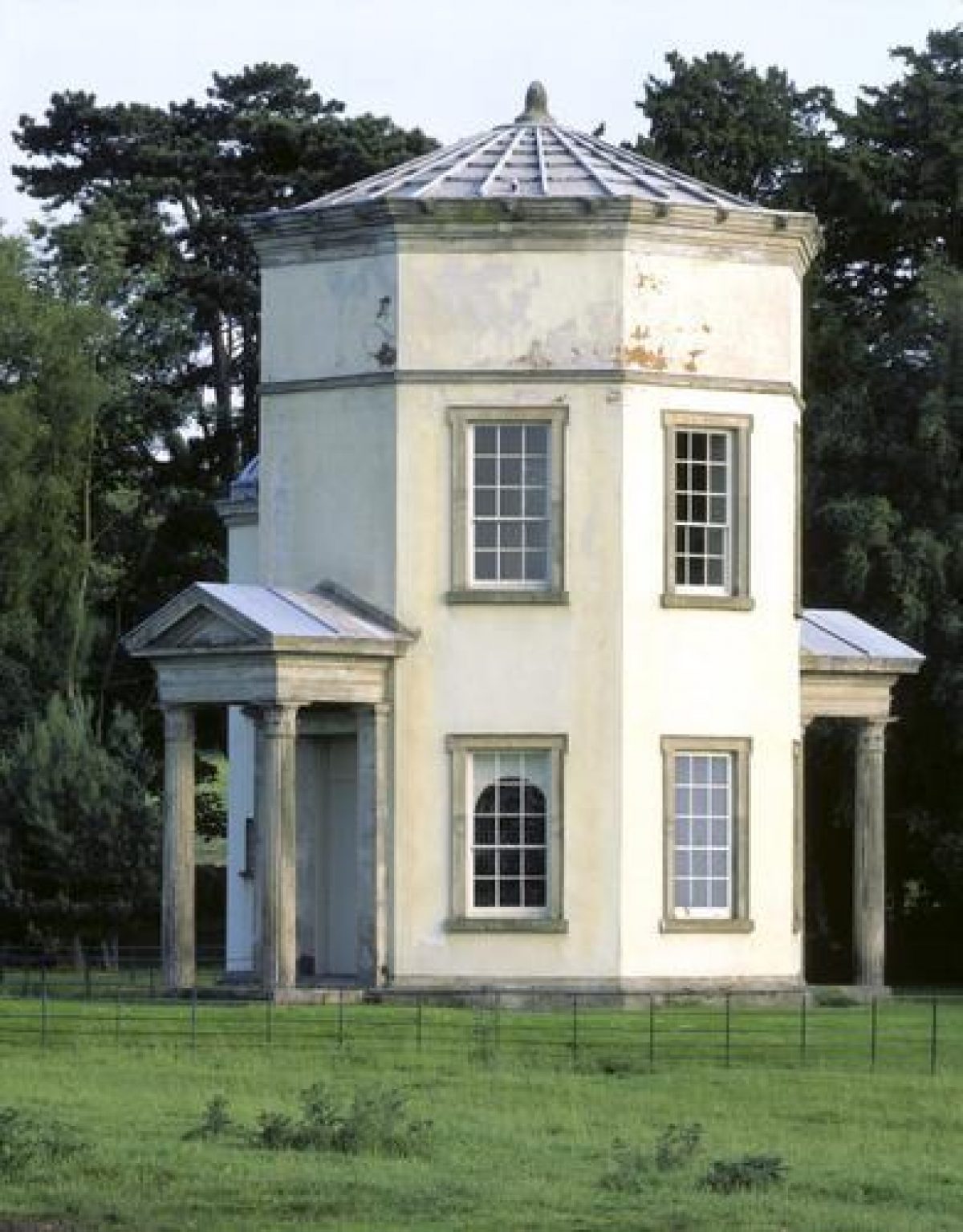
The Tower of the Four Winds (listed grade II*), a two-storey octagonal tower, stands c 500m south of the Hall. It was completed in 1765 to a design by James Stuart based on the Horlogium of Andronikos Cyrrhestes in Athens. When built it stood on an island at the south end of an artificial lake created by Thomas Anson, with Chinese bridges approaching its impressive pedimented entrances. The building faced the Palladian Bridge, Cascade with Colonnade and the Chinese Pagoda, features which, like the lake itself, were swept away during the changes made in the late C18 and early C19. Other lost features are an obelisk of c 1760 on Brocton Hill which blew down in the C19, and a Ladies Seat near the Lanthorn.
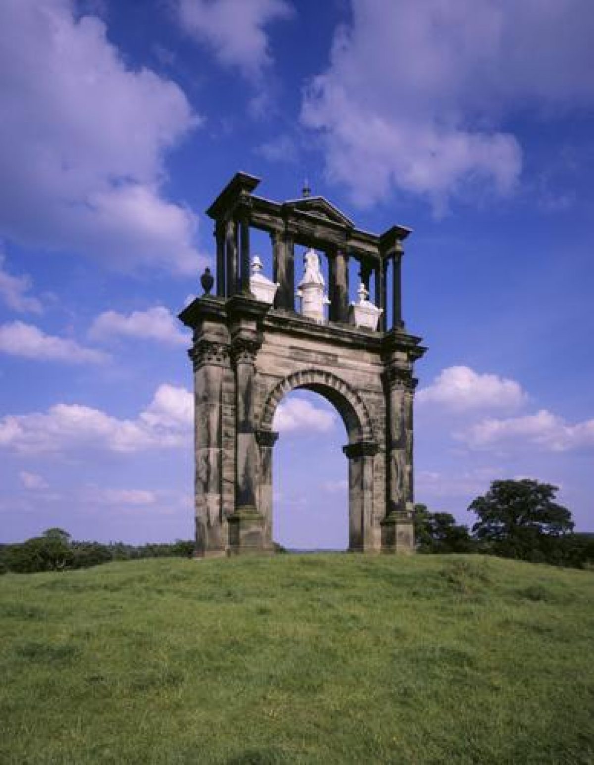
On the skyline c 500m to the south-west of Park Farm, on the ground rising to the Satnall Hills, is the Triumphal Arch (listed grade I), a copy by Stuart of the Arch of Hadrian in Athens. Begun in 1761 it was adapted in 1763 as a memorial to Admiral Anson, who had just died, and his wife, busts of whom stand on cenotaphs in the upper stage to either side of a central martial trophy.
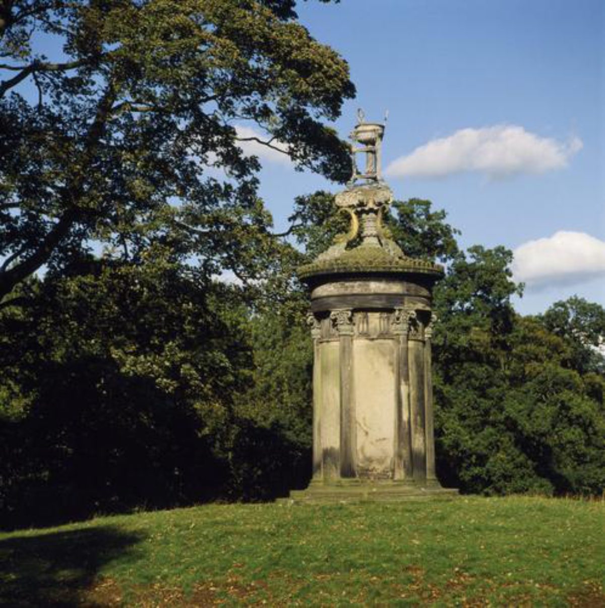
The third major monument in the park by Stuart, the Lanthorn of Demosthenes (listed grade I; also known as the Dark Lantern), stands on another knoll, on the west side of the drive from Milford and overlooking the River Sow, c 400m to the north-west of the Triumphal Arch. Built 1764-71, the monument is a copy of the Choragic Monument of Lysicrates in Athens. It takes the form of a squat column supporting a tripodic trophy, the latter replaced in fibreglass in 1965.
Park Farm (elements listed grade II* and II), used in the later C20 as a museum, lies immediately south of the Tower of the Four Winds, the ground floor of which was converted into a dairy c 1803, to a design by Samuel Wyatt. Park Farm, designed by Wyatt in 1805 with the advice of the consultant estate agent Nathaniel Kent, has a pattern-book quadrangular layout, with the farm steward's house on the side opposite the entrance and with the long flanking ranges housing stables and cattle sheds on the one side and a brewhouse and water-powered mill on the other. White Barn Farm (listed grade II*), 600m to the south, contained the barns and threshing machine. Built by Thomas Anson to serve his expanded holding at Shugborough, it too was remodelled by Wyatt who added its projecting wings with lunette windows and converted part of a hay barn to cottages (listed grade II*).
Passing from east to west through the southern part of the park is the Stafford to Tamworth railway line, planned in 1845. This however is carried under the main part of the landscaped grounds in a 750m long tunnel and is largely invisible therefrom. The tunnel entrances (listed grade II), most notably that of 1847 to the west, are more ornamental than is usual. Some 350m north-west of the Lichfield Lodge the drive to the Hall is carried over the railway by an elegant stone bridge (listed grade II) of 1847.
KITCHEN GARDEN
The walled kitchen garden (listed grade II) lies 250m south of Park Farm. The main compartment is c 140m long from north to south. Along the north wall is a gardener's house by Samuel Wyatt, on the south wall of which are two scars left by conservatories removed in the 1970s. The garden walls splay outwards to the south, that end of the garden at c 100m across being some 40m wider than the north end. A heated wall runs from east to west across the centre of the garden. The detailing of the brick walls is of good quality, with ashlar quoins to the various entrances. No historic glass survives. Today (1997) the southern half of the interior is used as a store, while the northern half is laid to lawns and beds. An additional garden compartment abuts the main garden to the east, and the whole walled complex is surrounded by a stone-walled ha-ha.
The walled kitchen garden was built 1805-6 to a design by Samuel Wyatt, to replace a walled garden which lay immediately north-west of the Hall. In the early C19 the garden establishment was highly regarded; in 1817 William Pitt described how the gardens served as 'a kind of Academy for the study of Horticulture, in which young men enter themselves to assist without pay for the purpose of improving themselves, and gaining knowledge in the art' (National Trust 1996, 43).
REFERENCES
Country Life, 115 (25 February 1954), pp 510-13; (15 April 1954), pp 1126-9; (22 April 1954), pp 1220-3; 150 (2 September 1971), pp 546-8; 161 (10 March 1977), pp 578-81
Archaeol J 120, (1963), pp 285-7
F Stitt, 'Shugborough: The End of a Village', Collections for a History of Staffordshire 6, (4th ser), (1970), p 86 et seq
P Connor, Oriental Architecture in the West (1979), pp 51-2
A Survey of Shugborough Hall Park & Garden, (Manpower Services Commission 1984)
S E Pybus, Shugborough: A Guide to the Monuments (1984)
G Jackson-Stops, An English Arcadia 1600-1900 (1992), pp 89-91
Shugborough, guidebook (National Trust 1996)
Maps
OS 6" to 1 mile: 1st edition published 1890/1894
OS 25" to 1 mile: 2nd edition published 1901
Archival items
Anson family and estate papers (D615/E[H]), (Staffordshire Record Office)
Description written: July 1997 Amended: November 1998
Register Inspector: PAS
Edited: September 1999
- Visitor Access, Directions & Contacts
Telephone
441889880166Access contact details
The site is open daily between March and October. See:
Directions
The site is 6 miles east of Stafford, off junction 13 of the M6.
Owners
Staffordshire County Council
St Chad's Place, Stafford, ST16 2LRThe National Trust
Heelis, Kemble Drive, Swindon, SN2 2NA
- History
The following is from the Register of Parks and Gardens of Special Historic Interest. For the most up-to-date Register entry, please visit the The National Heritage List for England (NHLE):
www.historicengland.org.uk/listing/the-list
HISTORIC DEVELOPMENT
Shugborough, which in the Middle Ages was one of the manors of the bishops of Lichfield, was purchased in 1624 by William Anson, a lawyer. In 1694 his grandson, also William, who married Isabella, the co-heiress of Charles Carrier of Wirksworth, rebuilt the Hall. He died in 1720 and was succeeded by his son Thomas, who for the remaining fifty-three years of his life devoted his energies to building, planting and collecting, making Shugborough into one of the finest landscapes in the country. Here, successively, were introduced some of the country's first chinoiserie, then picturesque rococo, and finally neo-classical garden buildings. Anson was able to greatly expand the scale of these works after 1762, when he inherited the fortune which had been built up by his younger brother George, Admiral Anson, 'the father of the British navy'. Thomas' heir was his nephew George, who assumed the name and arms of Anson. He (d 1789) was succeeded by his son Thomas Anson (d 1818), who in 1806 was created Viscount Anson and Baron Somerton and who married Anne Margaret Coke, daughter of the celebrated Norfolk improver. Under Thomas the Hall was remodelled, the park further enhanced, and improving estate buildings erected. His son, Thomas William Anson (d 1854), who was created Earl of Lichfield in 1813, ran through much of the family fortune and in 1842 racing debts precipitated a massive sale of Shugborough's contents. In 1960, on the fourth Earl's death, the Hall, park and contents were offered in part payment of death duties to the National Trust, which in turn leased the property to Staffordshire County Council. The Hall continues (1997) in part to be lived in as a family home.
- Associated People
- Features & Designations
Designations
The National Heritage List for England: Register of Parks and Gardens
- Reference: GD2171
- Grade: I
Features
- Tree Feature
- Description: Patrick Lichfield's arboretum.
- Kitchen Garden
- Description: Walled garden.
- Garden Terrace
- Lake
- Dairy
- Ferme Ornee
- Specimen Tree
- Description: Yew tree about 350 years old, recorded as the widest in Britain, with a crown circumference of 575ft (175 metres)
- House (featured building)
- Description: The house was re-built in 1694 and re-modelled between 1789 and 1818.
- Earliest Date:
- Latest Date:
- Key Information
Type
Estate
Purpose
Ornamental
Principal Building
Heritage Site
Survival
Extant
Hectares
288
Open to the public
Yes
Civil Parish
Colwich
- References
References
- {English Heritage Register of Parks and Gardens of Special Historic Interest}, (Swindon: English Heritage, 2008) [on CD-ROM] Historic England Register of Parks and Gardens of Special Historic Interest
- Pevsner, N. {The Buildings of England: Staffordshire} (Harmondsworth: Penguin, 1974) p. 236, 238. The Buildings of England: Staffordshire
- Pitt, W, {A General View of the Agriculture of the County of Stafford with observations on the means of its improvement} (1796) p97. General View of the Agriculture of the County of Stafford with observations on the means of its improvement
- Nightingale, J {Topographical and Historical Description of the County of Stafford} (1810)p1084-8. Topographical and Historical Description of the County of Stafford
- Gardens Survey Team, National Trust {Shugborough park & garden survey} (1984) Shugborough park & garden survey
- Related Documents
-
CLS 1/819
(Draft) Landscape Plan for Shugborough - Hard Copy.
Debois Landscape Survey Group - 1990
-
CLS 1/820
Landscape Management Plan for Shugborough - Hard Copy.
Keith Funnell Associates with Peter Fischer Landscape Design - 1994
-
CLS 1/822
Shugborough Park and Garden Survey, Vol.1 - Hard Copy.
Manpower Services Commission - 1984
-
CLS 1/823
Shugborough Park and Garden Survey, Vol.2 - Hard Copy.
Manpower Services Commission - 1984
-
CLS 1/826
Shugborough Hall Park, A Summary of its Development - Hard Copy.
Debois Landscape Survey Group - 1989
-
CLS 1/819