Introduction
Sheffield Park is a wooded landscape park of about 74 hectares, laid out in the mid and late 18th century by Lancelot Brown. There was further involvement by Humphry Repton and the development of the park continued in the 19th and 20th centuries. Features include four lakes, waterfalls and cascades, and an arboretum with a mix of native and exotic species including conifers, azaleas, rhododendrons and acers.
Terrain
The site falls generally from the north-west to the south-east.www.historicengland.org.uk/listing/the-list
A wooded landscape park with lakes, laid out in the mid and late C18, with work by Lancelot Brown and Humphry Repton and further developed as a garden of notable, exotic trees and shrubs in the late C19 and C20.
DESCRIPTION
LOCATION, AREA, BOUNDARIES, LANDFORM, SETTING
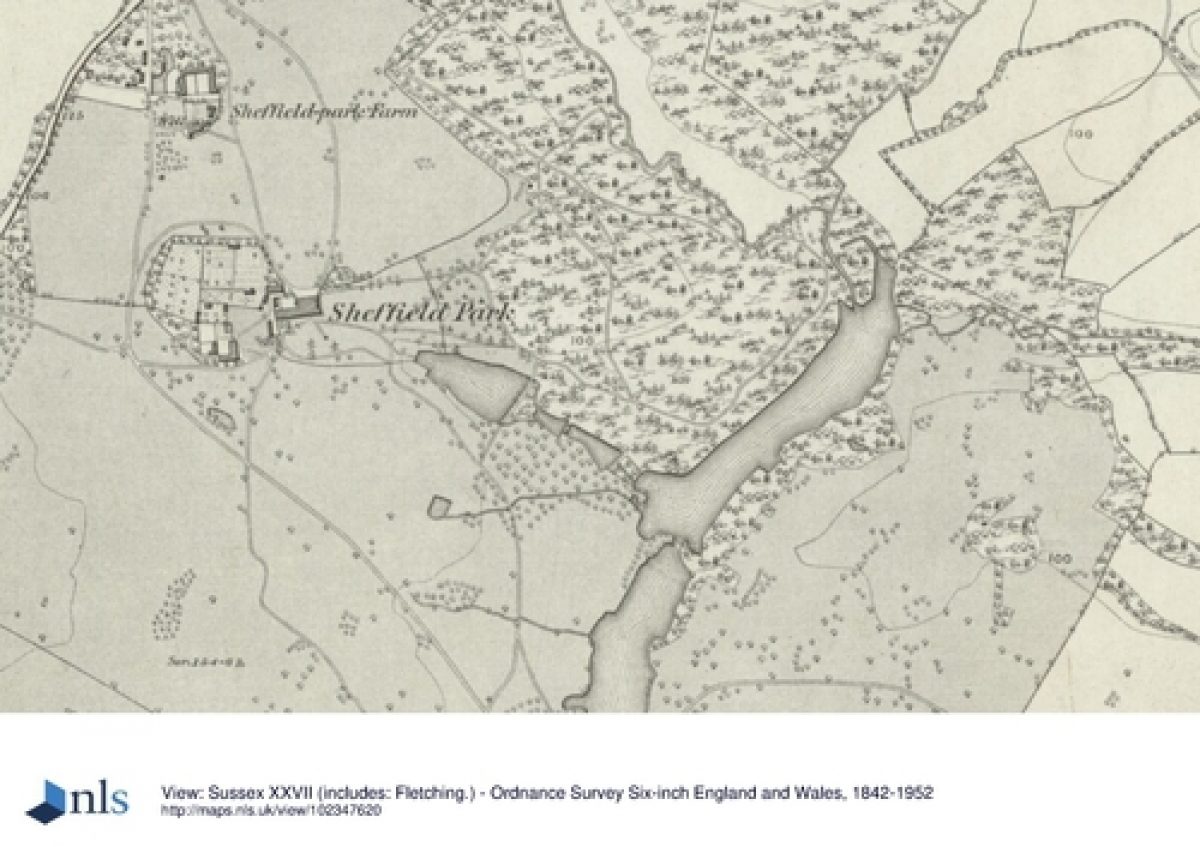
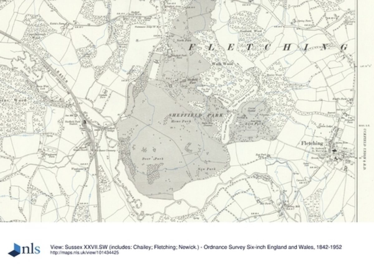
Sheffield Park lies adjacent to the A275, 3km from Danehill village to the north and 4km from North Chailey to the south. The village of Fletching lies about 0.5km east of the site. The National Trust garden and associated land covers c 74ha and the land in private ownership a further c 104ha. The ornamental gardens lie within the shallow valley of a south-flowing tributary of the River Ouse, the house standing on a crest above this valley to the west. The crest extends south-westwards before dropping down to the edge of the Ouse valley which runs west to east just beyond the site's southern boundary. The site falls generally from the north-west to the south-east. The site is bounded by the A275 on the west side and to the south-west by the valley of the River Ouse. The road to Fletching runs along the 0.5km of the northern boundary while to the north-east, east and south-east the site merges into rolling wooded farmland.
ENTRANCES AND APPROACHES
The entrance to Sheffield Park house is from the main A275 road, 0.25km south of its junction with the road east to Fletching. The drive, following a route established at least from the remodelling of the house in the late C18, passes under the crenellated arch of James Wyatt's pair of lodges (North and South Lodge, listed grade II). These are set some 30m back from the road and were extended to form larger properties in the early 1990s. The drive swings southwards in a gentle curve through the North Park to arrive at the north-east corner of the house.
A second entrance from the A275 beside a mid C20 lodge, about 0.5km south of North and South Lodges, leads to a drive running south-eastwards across the site to Fletching. This gives access to the Home Park on its south side and, c 0.25km from the A275, to the National Trust car park and garden on the north side.
Richard Gadesby's map of Sheffield Place of 1745 shows the main approach to the house on a similar route to the present one and lined with formal avenue trees while both entrances and drives are shown established on the estate map of 1774 by Bernard Scalé.
PRINCIPAL BUILDING
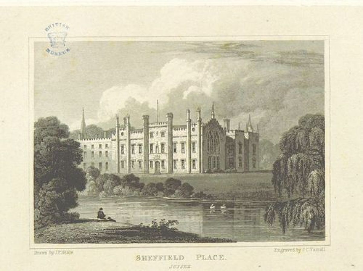
Sheffield Park (listed grade I) stands on level ground commanding extensive views over the chain of lakes in the gardens to the south-east and to Fletching church and the landscape eastwards beyond the site. Little is known of the appearance of the house prior to it being remodelled as a gothic-revival mansion by James Wyatt (1748-1813) in c 1776-7. Wyatt carried out further work from 1780 to 1790, followed by work by Benjamin Henry Latrobe (1764-1820) in 1790. Further alterations and enlargement were carried out in 1912. The house was converted into fifteen apartments, offered for sale separately, in the early 1990s while to the immediate west of the house, an extensive housing court was built at the same time on the site of what had been, from at least 1774 until the late C19, formal, enclosed gardens. The C19 stable block, in use as business units, lies c 25m south of the housing court.
Some 300m north of Sheffield Park house and to the west of its main drive is Sheffield Park Farm and farmhouse (both listed grade II), with a model farm layout dating from 1808 and with an C18 or early C19 dovecote (listed grade II).
GARDENS AND PLEASURE GROUNDS
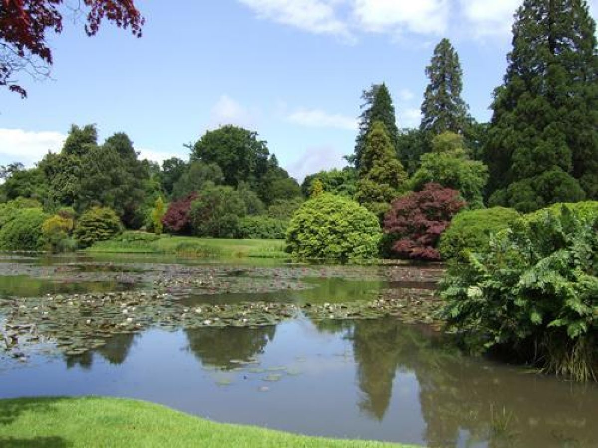
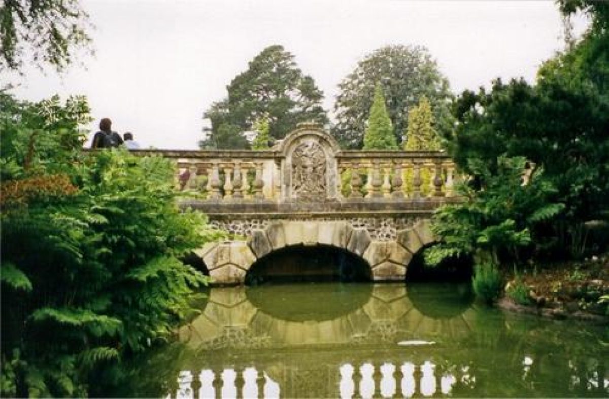
A level lawn with a central stone fountain extends c 50m eastwards from the house while a gravelled walk, lawn and shrubbery along its southern elevation overlook the head of a steep-sided grassy valley which continues south-eastwards into the National Trust (NT) garden. The lawns around the house are separated from the NT garden by a wire fence and shrubbery but the principal axial view south-eastwards down the gardens, a feature of both C18 and C19 landscaping, is maintained. Immediately below the lawns two lakes, First Lake or Ten-Foot Pond and Second or Middle Lake, descend south-eastwards towards the main north/south valley. The lakes are linked by a waterfall which is crossed by the balustraded Top Bridge (restored 1997). Scalé's map of 1774 shows a single, narrow lake on the site of First Lake which is depicted surrounded by open lawns and trees in Samuel Hieronymus Grimm's view of 1787. Humphry Repton (1752-1818), on visits to the site in 1789 and 1790, seems to have redesigned it as a series of four small lakes which are shown on the OS preliminary drawings (surveyed 1789-1808). He also increased the planting around the lakes. If Repton ever produced a Red Book for Sheffield Park it has not survived. In the late C19, the third Earl drained and enlarged Ten-Foot Pond and created the present Second Lake, commissioning James Pulham and Sons Ltd to construct the sandstone waterfall and, between 1882 and 1888, the stonework for Top Bridge.
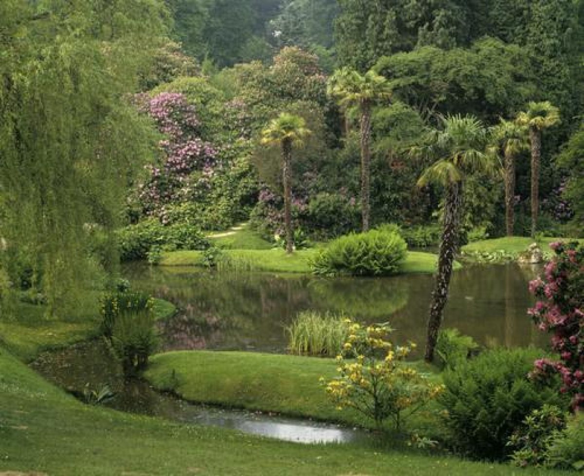
The present main garden walk follows a route north-east from the public entrance around the perimeter of First and Second Lakes. Planting around the lakes includes surviving trees planted by the third Earl towards the end of the C19 and the rhododendron collection begun by Arthur Gilstrap Soames. North-east of the lakes is Walk Wood, now containing the Big Tree Walk of large North American conifers, the Coronation Walk commemorating the coronation of George V, the Palm Avenue and the Jubilee Walk. Walk Wood is recorded as Sheffield Wood on Gadesby's map of 1745 and by 1774 Scalé's map shows it crossed by a network of named walks. Little evidence survives of Lancelot Brown's (1716-83) work on the site but he seems to have developed the path system in Walk Wood (NT guidebook). Part of the boundary of the Wood with the North Park to the west is marked by a surviving length of the ha-ha shown on Gadesby's map of 1745.
South-west of First and Second Lakes are further walks, a stream garden and the c 0.5ha Fish or Storage Pond. The planting in this area was developed in the C20 by both Gilstrap Soames and the National Trust from the open parkland shown on the OS 1st edition map surveyed 1873(5. Second Lake terminates in a further waterfall by Pulham and is crossed by Lower Bridge, built by the Trust in 1957 to replace the late C19 stone bridge. There are vistas north-westwards to the house. To the south-east below the waterfall lies the main north/south valley containing Third and Fourth Lake or Upper and Lower Woman's Way Ponds. They are linked in the valley centre by the Grand Cascade, built in the late C19, and the Cascade bridge. The lakes are shown on Scalé's map of 1774 as one continuous lake covering a similar area . This appears to have been constructed by Lord de la Warr between 1745 (it is absent from Gadesby's map of 1745) and 1769. It is shown divided into its present two lakes by 1795 (Gardner and Gream map); the work may have been carried out by Repton.
Queen's Walk, opened in 1977, leads north-eastwards from Lower Bridge around the north side of Third Lake to the site of the Cricket Field, laid out in the late C19 by the third Earl, on its south-east side. The C20 plantation was cleared from the field in the 1990s and it is now managed as meadow.
A full description of the planting in the National Trust garden, including replacement planting after severe storm damage in 1987, may be found in the current guidebook.
PARK
The park divides roughly into three main areas. North Park lies between the house and the site's northern boundary. It is laid down to open pasture with one or two clumps and a few individual trees. South-west of the house the Home Park extends to the site's southern boundary. It is under arable cultivation but retains a number of sizeable clumps and a few individual trees. A medieval park existed at Sheffield Park although its extent is not clear. Scalé's map of 1774 shows a pattern of parkland planting in the North and Home Park of which much is still shown on the OS 3rd edition published in 1911. Some of the trees surviving in the 1990s appear to correspond to the C18 layout. There is evidence to suggest that Brown's work included felling to improve the parkland landscape (NT guidebook).
The north-eastern half of the East Park is wooded; the south-western part is more open but still well treed. By 1997, 5.5ha of this latter part of the East Park was cleared and will be managed as wood pasture. Map evidence shows the land for laying out East Park having been added to the estate between 1774 and 1795; it began to change from open parkland to woodland in the late C19.
KITCHEN GARDEN
The 90m long, rectangular kitchen garden lies parallel to the western boundary of the site, c 130m west of the house. It is surrounded by high red-brick walls, contains C19 glasshouses and a gardener's cottage and outbuildings and is now (1997) laid out as a vineyard and nursery. The garden was built in the late C19 to replace the enclosed gardens immediately west of the house which were laid to lawn at the same time.
REFERENCES
Victoria History of the County of Sussex VII, (1940), pp 378-9
Country Life, 109 (18 May 1951), pp 1552-7; 126 (17 September 1959), pp 286-9; no 36 (3 September 1987), pp 136-9
D Stroud, Humphry Repton (1962), pp 36, 39, 42, 172
I Nairn and N Pevsner, The Buildings of England: Sussex (1965), pp 605-6
D Stroud, Capability Brown (1975), pp 238-9
Sheffield Park, guidebook, (Sheffield Park 1978)
T Wright, The Gardens of Britain 4, (1978), pp 180-5
G Carter et al, Humphry Repton (1982), p 163
The National Trust Garden Survey, Sheffield Park Garden, (National Trust 1983)
Garden History 17, no 2 (1989), pp 174-5
Storm Damage 1990, Sheffield Park Grant Aid Application, (National Trust 1991)
Sheffield Park, guidebook, (National Trust, nd)
Maps
Richard Gadesby, Sheffield Place, 1745 [reproduced in National Trust Garden Survey 1983]
Bernard Scalé, A Survey ...of Sheffield Place, 1774 (East Sussex Record Office)
W Gardner and T Gream, A topographical map of the County of Sussex,1" to 1 mile, surveyed 1795
Estate Timber Survey, 1820 (East Sussex Record Office)
C and J Greenwood, A Map of the County of Sussex... ,1"to 1 mile, published 1825
OS surveyor's drawing for 2" series, surveyed 1789-1808 (British Library maps) [copy in ESRO]
OS 6" to 1 mile:
1st edition surveyed 1873-5
2nd edition published 1899
3rd edition published 1911
Description written: July 1998
Register Inspector: VCH
Edited: March 2000
- Visitor Access, Directions & Contacts
Telephone
0844 800 1895Website
http://www.nationaltrust.org.ukAccess contact details
The site is open daily from 10.30am. It is closed on Christmas Day. http://www.nationaltrust.org.uk/place-pages/295/pages/opening-times-calendar
Owners
The National Trust
Heelis, Kemble Drive, Swindon, SN2 2NA
- History
The following is from the Register of Parks and Gardens of Special Historic Interest. For the most up-to-date Register entry, please visit the The National Heritage List for England (NHLE):
www.historicengland.org.uk/listing/the-list
HISTORIC DEVELOPMENT
Sheffield Park was in the ownership of the De La Warr family in 1292. It passed through various other hands including those of Thomas Howard, Duke of Norfolk in the mid C16 and the Sackville family in the late C16. It was purchased by the Neville family in 1623 but was owned and occupied again by the de la Warr family in the mid C18. In 1769 the second Earl de la Warr sold the Sheffield estate to John Baker Holroyd for whom James Wyatt remodelled the house. Lancelot Brown was called in by Holroyd in 1776 to improve the parkland and woodland walks and in 1789-90, Humphry Repton advised on redesigning the lakes east of the house. Holroyd was created Baron Sheffield in 1781 and Earl of Sheffield in 1816. He was succeeded by his son in 1821 and by his grandson, the third Earl, in 1876 who laid out the basic skeleton of the present-day planting.
The third Earl died in 1909 and the estate was purchased in 1910 by Arthur Gilstrap Soames who carried out extensive ornamental planting. He died in 1934 and his widow, Agnes, cared for the Park until her nephew took over in 1949. He restored the Park after its wartime use but sold up in 1953. The house, garden and estate were separated; Sheffield Park Farm and the Home Park were purchased by the Trustees of the Knole estate and the house and North Park by L F McCardle. He sold to the Radford family in 1971. In the early 1990s the house was purchased and converted to apartments by Period Homes and the Arundel Estate Sussex Ltd built a housing court in the grounds. Both these are managed by residents' associations. The ornamental gardens were purchased by the National Trust in 1954 who added further land including Walk Wood and Manley Wood in 1982.
- Associated People
- Features & Designations
Designations
The National Heritage List for England: Register of Parks and Gardens
- Reference: GD1043
- Grade: I
Features
- Lake
- Description: A group of four lakes, two created by Lancelot Brown and two by James Pulham, form the centrepiece of the park.
- Specimen Tree
- Pulhamite
- River
- Description: River Ouse.
- House (featured building)
- Now Apartments
- Description: James Wyatt re-modelled the house after 1769. It was converted into apartments in the early-1990s.
- Earliest Date:
- Parkland
- Waterfall
- Arboretum
- Cascade
- Key Information
Type
Park
Purpose
Ornamental
Principal Building
Domestic / Residential
Survival
Extant
Hectares
74
Open to the public
Yes
Civil Parish
Fletching
- References
References
- Stroud, D {Capability Brown} (1975) pp 238-239 Capability Brown (Country Life article)
- Carter, G et al {Humphry Repton landscape gardener 1752-1818} (1982) p 163 Humphry Repton landscape gardener 1752-1818
- {The English Heritage Register of Parks and Gardens of Special Historic Interest} (Swindon: English Heritage 2008) [on CD-ROM] Historic England Register of Parks and Gardens of Special Historic Interest
- Stroud, D {Humphry Repton} (1962) pp 36, 39, 42, 172 Humphry Repton
- Nairn, I and Pevsner, N {The Buildings of England: Sussex} (Harmondsworth: Penguin, 1965) pp 605-606 The Buildings of England: Sussex
- Saltzman, L.F. {Victoria County History: Sussex, Volume 7} (Oxford: Oxford University Press, 1940) 378-9 Victoria County History: Sussex, Volume 7
- Hitching, C {Rock Landscapes: The Pulham Legacy} (Garden Art Press, 2012) Rock Landscapes: The Pulham Legacy
- Debois Landscape Survey Group; ACTA {Sheffield Park Gardens, Sussex Conservation Management Plan 2 vols} (2010) Sheffield Park Gardens, Sussex Conservation Management Plan 2 vols
- Gardens Survey Team, National Trust {A survey of Sheffield Park garden, East Sussex} A survey of Sheffield Park garden, East Sussex
- Smith, Aiden {Sheffield Park Garden: Gardens Survey} (1983) Sheffield Park Garden: Gardens Survey
- Wheeler, Richard {Sheffield Park: Conservation Statement} (2005) Sheffield Park: Conservation Statement
- Related Documents
-
CLS 1/162/1
A Survey of Sheffield Park Garden, East Sussex - Hard copy
Nat. Trust Survey team financed by Manpower Services Commission - 1984
-
CLS 1/162/1