Introduction
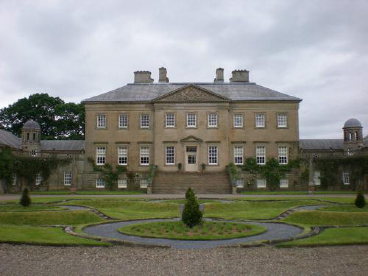
The parkland, woodland and formal garden at Dumfries House are associated with a mid-18th-century Palladian mansion, although some of the parkland planting is from an earlier date. The formal garden is a parterre on two levels. After renovation the house opened to the public in June 2008.
The following is from the Historic Environment Scotland Gardens and Designed Landscapes Inventory. For the most up-to-date Inventory entry, please visit The Historic Environment Scotland website:
Location and Setting
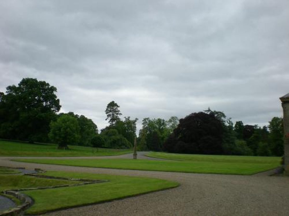
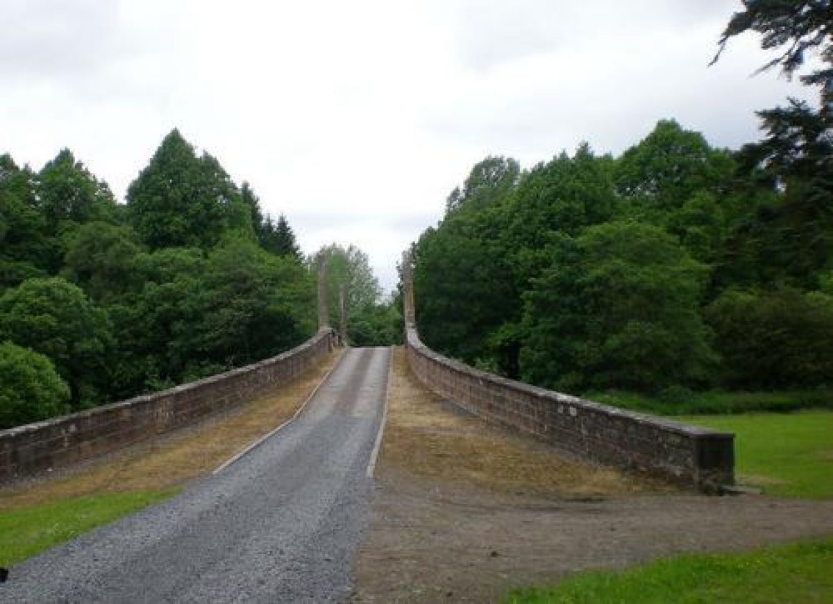
Dumfries House lies in the valley of the Lugar water some 15 miles (24km) south-east of Ayr and 2 miles (3km) west of Cumnock. The broad valley setting, with its gently sloping hills to the north and south, provides extensive views of the parkland from either side of the valley. The house commands a fine prospect to the north and is itself a feature in the designed landscape when viewed from the north side of the valley, and particularly from the original main approach from Auchinleck which curves through the parkland and across the Adam Bridge to the House. The policy woodlands are the most significant feature in the landscape viewed from outside the park.
The house is set on the south side of the Lugar Water, overlooking the river. The policies today extend from Hinnieston Wood in the west, north to the north- east lodge, east to Tarringzean Castle, and south to the A70. The woodlands south of the A70, particularly the roundel plantings, were planted as part of the designed landscape to be viewed from within the park. Dettingen Mount is particularly significant in the landscape.
These distinctive roundels were planted before General Roy's map of 1750 and feature prominently on this map, as does the east/west avenue planting lining the main road through the estate at that time. A formal design centering on Lochnorris castle is also shown. A plan at the estate office by William Smith in 1756 shows a simplified version of this layout at about the time the new house was being built. This names the vistas through the plantings on Mount Allan and shows the 'bouline green' to the east of the house. By 1772 John Home's plan reveals a shift in emphasis with the formal elements of the design reduced to those focussing on the new Dumfries House, and with formal rides centering on the bowling green in Shaw Wood. A new kitchen garden is shown to the north of the river, and the 'Old Garden' is marked by the bridge.
At some time between the production of this map and the 1st edition OS map of 1854, the main road was moved southwards out of the policies to its present route.
The former line of the road became the drive, leaving the two south lodges at Stockiehill stranded in the new park. The main approach today leaves the A70 and approaches the house from the south, through the west gates. The structure of the designed landscape has since remained similar to that shown on the 1854 map. There are around 1,320 acres (535ha) in the designed landscape today.
Landscape Components
Architectural Features
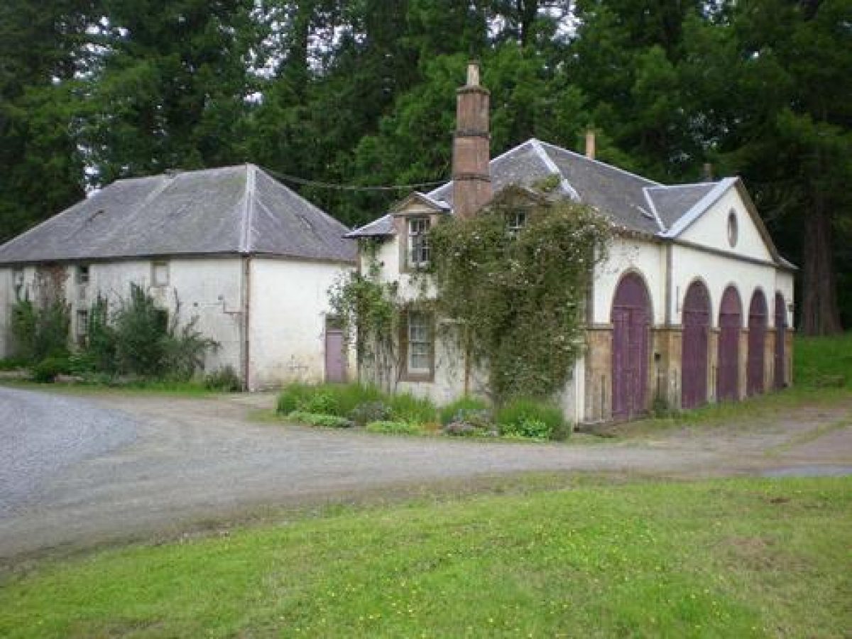
The mansion home was designed by Robert, John and James Adam and built between 1754-9; it is listed A. The Avenue Bridge designed by John Adam is also listed A; it has been renovated in recent years and the ball finials stored separately to prevent further vandalism. The Doocot predates the mansion house and is dated 1671; it was repaired in 1842 and is listed A. The Temple, which originally formed a feature on the North Avenue, is also listed A; it is in need of restoration. The West Gates, Stockiehill Lodges, and the ruins of Tarringzean Castle in the east of the park are listed B, as is the lectern-style sundial near the house. The Ice House and the Coach- house are listed B; the Lady's Bridge and the Waterloo Bridge are listed C(S). The offices, cottages and barn buildings are at Dumfries House Mains (formerly called Causeyhead) to the south of the house. Other ornamentation includes the statues in the rose garden, and the crucifix erected in memory of the 3rd Marquess along Lord Bute's Walk overlooking the park near the Lady's Bridge. A well head near the Avenue Bridge has been demolished. The Sawmill is of interest, as is the hand operated sluice gate to the millpond.
Parkland
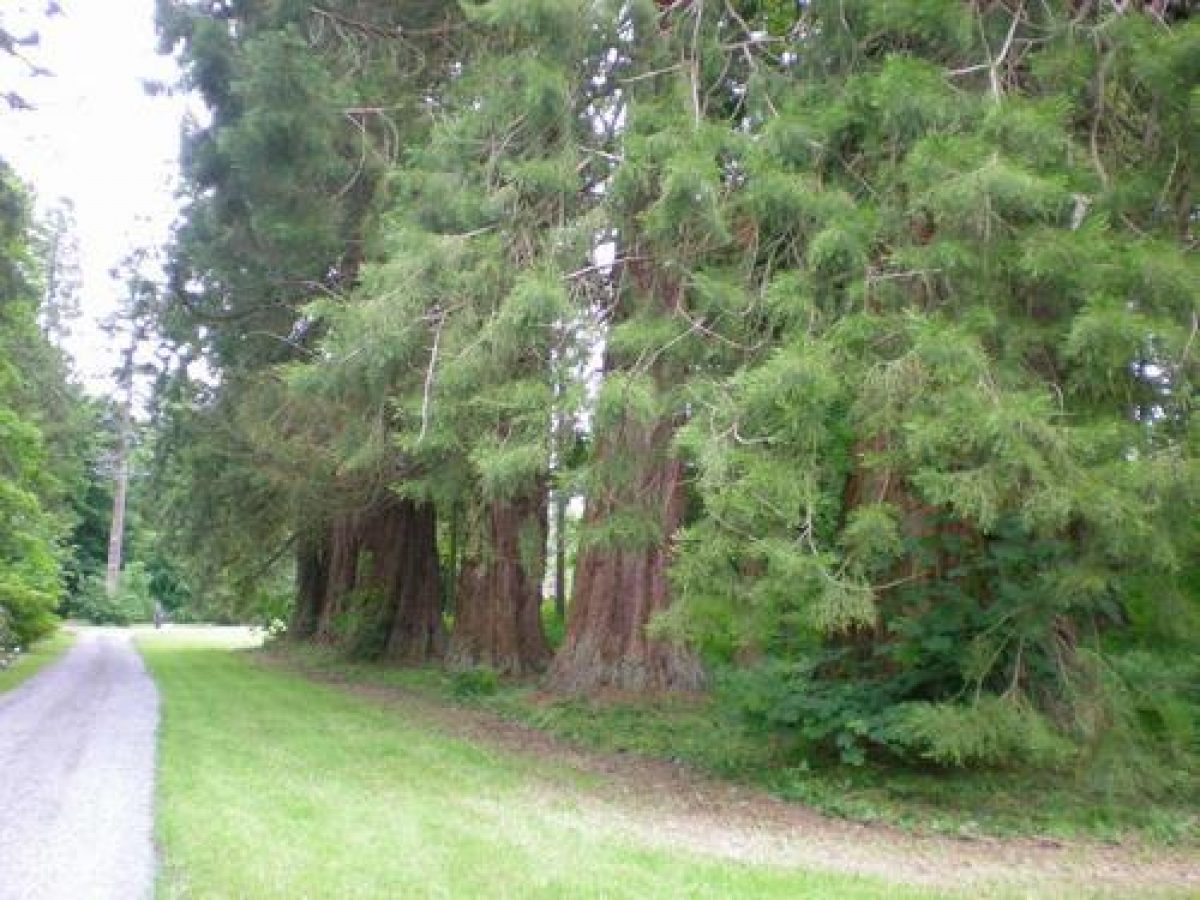
The park extends either side of the Lugar Water and is grazed. There are many parkland trees: some dating back to the 1700 plantings, some dating from c.1800, and some more recent additions. Species include sycamore, horse chestnut, oak and beech. The former main east/west avenue has been lost but the Beech Avenue north of the river up to the East Lodge remains, as do remnants of the former north avenue to the Temple. There are some interesting specimen trees near the house, including a weeping cypress, a cut-leaf beech and some copper beech. The Sequoia Avenue by the coach-house was planted in the late 19th century and runs up towards the Avenue Bridge. The D's plantation is a feature in the park due east of Shaw Wood. It was planted with beech in the early 1800s, many of which have since been lost. The oak avenue between the Sawmill and Avenue Bridge was replanted recently.
Woodland
Shaw, Hinnieston and Tarringzean Woods are all planted with mixed hardwood species including sycamore, beech, lime and horse chestnut. There are pockets of more recent coniferous plantings within these woodlands, particularly in the former pleasure grounds of Shaw Wood. To the south of the A70, Broad Wood and the roundel plantings are now coniferous plantings. One of the mounts had been planted in c.1700 with Scots pine and has been replanted recently. A poplar plantation has been introduced near the Avenue Bridge in an area suffering from mining subsidence.
Woodland Garden
Woodland Walks extend through Shaw Wood, along Lord Bute's Walk, and west of the house. Lady Elizabeth's Walk extends alongside Polcaulk Burn. Plans existed in 1772 for a very complicated woodland garden to the east of the house; the Bowling Green was certainly put in about this time and the yews which surround it are still there today, although the green itself has been planted up with pine and sycamore. Many of the paths in this area remain, although some have been planted up.
More walks are shown along the Polcaulk Burn to the west of the house and adjacent to the west drive. The woodland canopy here consists of sycamore, lime, beech and horse chestnut, with later additions of copper beech, Prunus, Rhododendrons and azaleas.
The Gardens
The formal garden to the south of the house consists of a parterre of raised circular beds, now filled with roses. Lower island beds complete the pattern. An early photograph shows clipped trees in tubs arranged in a pattern at each corner of the parterre.
- Visitor Access, Directions & Contacts
Telephone
01290 425 959Access contact details
Dumfries House is open for pre-booked house tours on some days of the week. For details see: https://dumfries-house.org.uk/visitors
Directions
https://dumfries-house.org.uk/visitors/getting-to-dumfries-house
Owners
Great Steward's Dumfries House Trust
- History
The following is from the Historic Environment Scotland Gardens and Designed Landscapes Inventory. For the most up-to-date Inventory entry, please visit the Historic Environment Scotland website:
http://portal.historic-scotland.gov.uk/hes/web/f?p=PORTAL:DESIGNATIONS:0
Reason for Inclusion
The gardens, parkland and woodland make an enormous contribution to the surrounding Ayrshire valley scenery and date from the 17th century or earlier. The designed landscape also forms a very impressive setting for the category A listed Dumfries House.
Main Phases of Landscape Development
No information available.
Site History
By 1440 the estate belonged to the Craufords of Loudoun, when it was known as Lochnorris. The site of the house 'Ward of Lochnorris' is known to be north of the present-day coach-house, by the river. The estate belonged to the Craufords until 1635 when it was purchased by William, 2nd Earl of Dumfries. His daughter, Penelope, married the second son of the 1st Earl of Stair and the Dumfries title passed into the Dalrymple family. William Dalrymple, the 4th Earl of Dumfries, commissioned John, Robert and James Adam to design and build a new house between 1754-59. The pleasure grounds to the east of the house were also redesigned during this period.
In 1814 the titles and lands passed to the Stuart family of Mount Stuart, Bute, (q.v.) when the 7th Earl of Dumfries succeeded to the Bute estate and titles. Plans for a more formal garden to the west of the house, and dated 1893, were not carried out. Dumfries House is lived in today by the Dowager Marchioness of Bute.
- Associated People
- Features & Designations
Designations
Historic Environment Scotland An Inventory of Gardens and Designed Landscapes in Scotland
Features
- Icehouse
- Temple
- Dovecote
- Earliest Date:
- Latest Date:
- Sundial
- Ruin
- House (featured building)
- Earliest Date:
- Latest Date:
- Key Information
Type
Estate
Purpose
Ornamental
Principal Building
Heritage Site
Survival
Extant
Hectares
581.7
Open to the public
Yes
- References
References
-
Historic Scotland, 'Dumfries House', {Gardens and Designed Landscapes},
- Peter McGowan Associates with Christopher Dingwall, 'Dumfries House', in {Ayrshire Garden and Designed Landscape Survey} (Prestwick: South Ayrshire Council, 2007) [on CD-ROM] Ayrshire Garden and Designed Landscape Survey
- Millar, A. H., {The Castles and Mansions of Ayrshire with Historical and Descriptive Accounts} (Glasgow: Grimsay Press, 2004), pp. 70-1 The Castles and Mansions of Ayrshire with Historical and Descriptive Accounts
- Close, R. (ed), {Ayrshire and Arran: An Illustrated Architectural Guide} (Edinburgh: The Rutland Press, 1992), pp. 140-1 Ayrshire and Arran: An Illustrated Architectural Guide
- Gordon, J. (ed), {The New Statistical Account of Scotland} ([n.p.]: [n.pub.], 1845), Vol. V, pp. 475-91 The New Statistical Account of Scotland
- {Ordnance Survey County Series Six Inch} (Southampton, 1854) Ordnance Survey County Series Six Inch
- Captain M. J. Armstrong and Son {A New Map of Ayrshire} (1775) A New Map of Ayrshire
- William Roy {Military Survey of Scotland} (1750) Military Survey of Scotland
- Joan Blaeu {Atlas Novus - South Carrick/North Carrick/Kyle/Cunninghame} (Amsterdam, 1654) Atlas Novus - South Carrick/North Carrick/Kyle/Cunninghame
- Land Use Consultants, {An Inventory of Gardens and Designed Landscapes in Scotland} ([n.p.]: The Countryside Commission of Scotland, 1987), Vol. 2, pp. 232-36 and p. 388 An inventory of gardens and designed landscapes in Scotland
Contributors
Historic Scotland
-
Historic Scotland, 'Dumfries House', {Gardens and Designed Landscapes},
- Related Documents
-
CLS 1/948
Front Garden Report and Recommendations - Digital copy
Peter McGowan Associates with Christopher Dingwall - 2008
-
CLS 1/948