Introduction
Chillington has the remains of an early formal layout, formal gardens, pleasure grounds and landscape park. The site covers approximately 344 hectares, and dates from around 1720 and earlier. Between 1761 and 1780, Capability Brown and James Paine were involved, and in 1911 there was work by Inigo Triggs.
Terrain
Chillington Hall stands on a slight rise, with the ground falling away to the east and south.The following is from the Register of Parks and Gardens of Special Historic Interest. For the most up-to-date Register entry, please visit The National Heritage List for England (NHLE):
A park landscaped by Lancelot Brown c 1760 associated with a country house.
DESCRIPTION
LOCATION, AREA, BOUNDARIES, LANDFORM, SETTING
Chillington lies in the wooded country bordering Shropshire, c 10km north-west from Wolverhampton and 3km south-west of Brewood, in which parish it lies. The village of Chillington was largely swept away by Brown, and all that remains is an unmetalled lane known as Chillington Street and two timbered and thatched cottages. Chillington Hall stands on a slight rise, with the ground falling away to the east and south. The area here registered comprises c 344ha.
ENTRANCES AND APPROACHES
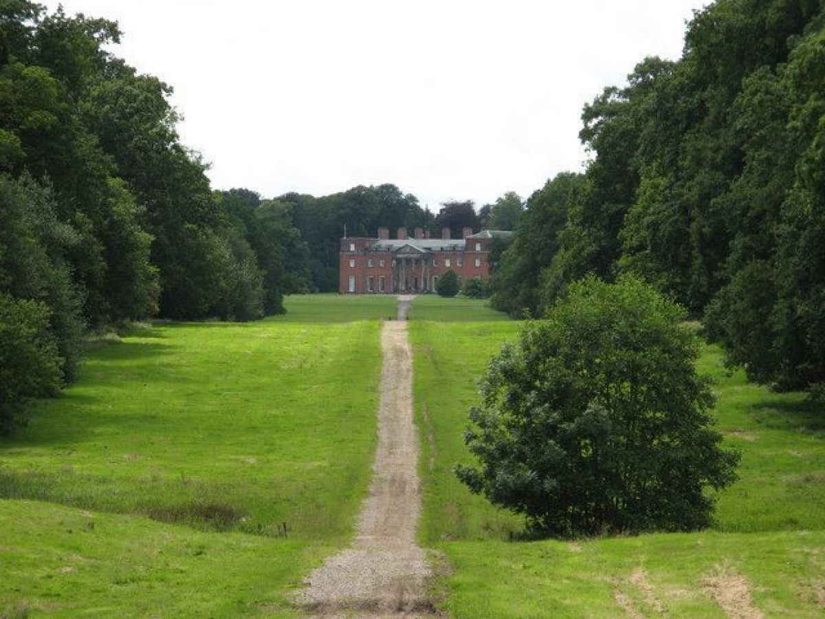
The most imposing approach to the Hall is via the drive which runs south-west for 1.5km up the centre of the Upper Avenue, described in 1727 as 'lately made by Peter Giffard' (VCH 1959, 29). The Upper Avenue ends at Giffard's Cross on Port Lane. Here is an C18 gateway (listed grade II) with four tall, rusticated ashlar piers with ball ornaments flanking a central double cast-iron gate and two single outer gates. On its north side is Giffard's Cross Lodge (listed grade II), a small, late C18, red-brick Palladian building. A wooden cross (listed grade II) within the garden marks the site where, c 1510, a panther was reputedly shot by Sir John Giffard (d 1556). From here the drive continues east for a further 1.5km up the Lower Avenue, shown on a map of 1775. Midway along its length Lower Avenue crosses over the Shropshire Union Canal via A wooden cross (listed grade II) within the garden marks the site where, c 1510, a panther was reputedly shot by Sir John Giffard (d 1556). An early C19 pair of one-and-a-half-storey brick cottages at its end presumably served as a gate lodge to the similarly dated stone-walled gateway which led from the minor road here into the Avenue.
Another approach to Chillington is via a 300m long, tree-lined drive from the north. This leads to the north-east corner of the stables and farmyard complex, from where a drive loops south-east around the front of the Hall before running across the park to become the carriage drive along the south side of The Canal. This drive is the third approach to Chillington and runs for 4km to Codsall Wood where there is an C18 lodge (listed grade II). Before the M54 was constructed a track forked south from this drive to Whitehouse Lane.
At the north-west corner of the park is another gate with C18 rusticated ashlar piers with ball ornaments, beneath which are the family coat of arms of three stirrups. There is a lodge building on the north side. The drives east and south from this survive in part as forest tracks.
PRINCIPAL BUILDING
In 1718 the existing house at Chillington was partially demolished and a new, south-facing, three-storey brick range constructed, probably by Francis Smith (1672-1738) of Warwick. That range was retained when a much enlarged house (listed grade I) was begun in 1786, the year after Thomas Giffard came of age, to a design by Sir John Soane (1753-1827). The main, east front of that has a central Ionic portico of Tunstall stone and is of two storeys, with end pavilions to mask the east end of Smith's earlier, and taller, south range. Soane's house was intended to be stuccoed, but in the event the brick was left bare, possibly to blend in with the earlier work. Later alterations and extensions have been minor.
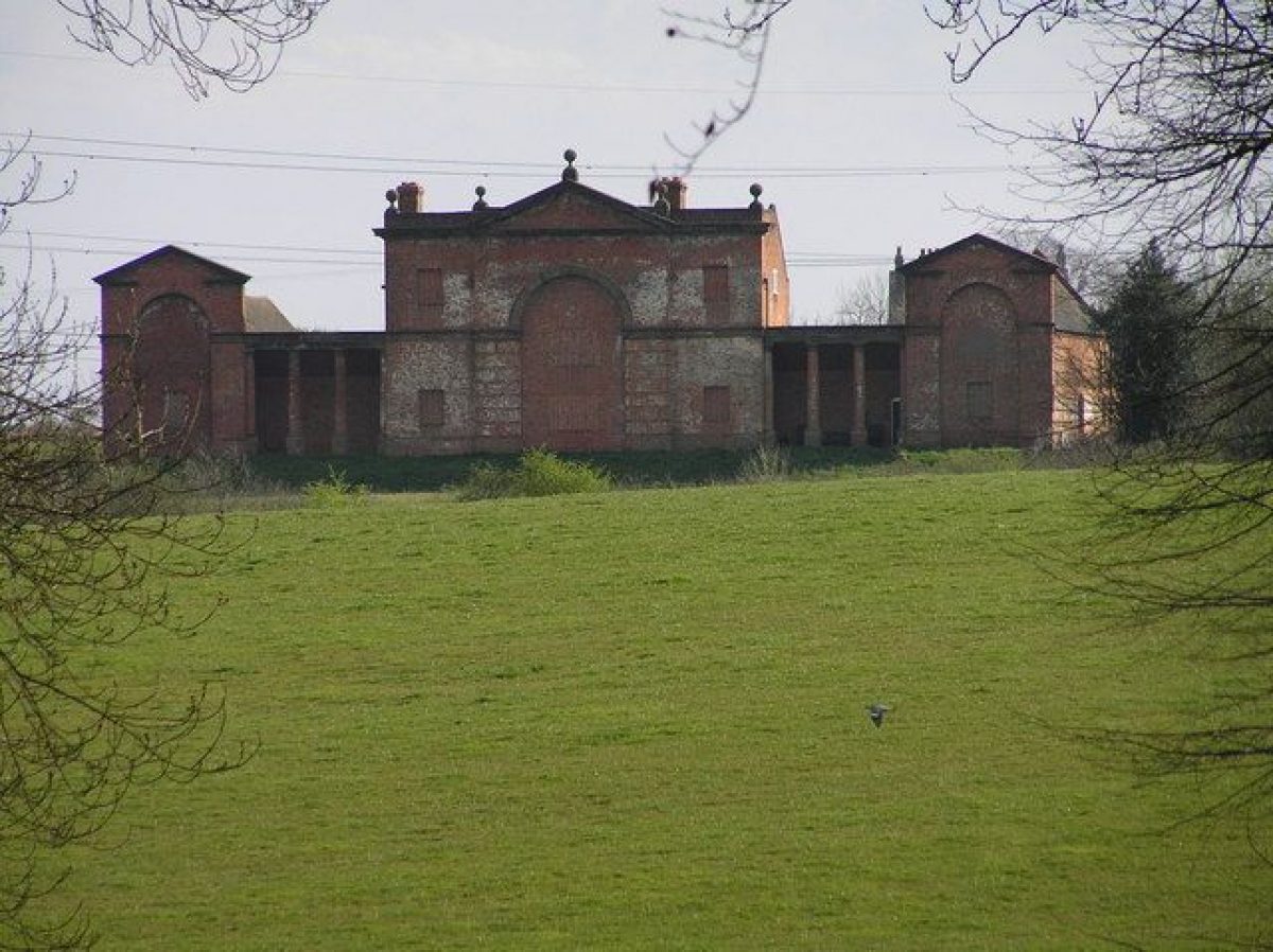
Some 300m to the west of the Hall, and immediately to the east of the kitchen garden, is a large and fine stables and home farm complex (components listed grade II*) of several C18 phases.
GARDENS AND PLEASURE GROUNDS
A semicircle of lawns runs around the eastern side of the Hall, with iron railings separating them from the park. To the south of the Hall is a geometric arrangement of rose beds with a macrocarpa hedge c 80m to the south, the main elements to survive from a garden laid out in 1911 by Inigo Triggs (d 1923). From here a straight walk leads west, passing to the south of The Bowling Green Arch (listed grade II*), a monumental stone screen of c 1730 with gates believed to be by Robert Bakewell. The gates lead through to a yew-hedged rectangular lawn, at the north end of which is a monument to the poet Cowper (who composed a verse about a grove of oak trees planted at Chillington in 1790), moved here from its original location in the park in the later C20. From the Bowling Green Arch the straight walk continues west as the Wall Walk, which runs parallel to and south of the south side of the stables and farm complex, and then passes south of the kitchen gardens and onwards to the woodlands at the north end of The Pool. Rhododendrons and azaleas line the Walk.
To the south of the Wall Walk is The Grove, a rectangular arboretum planted in the later C19. It measures c 300m east/west by 200m north/south. Its north-western part has been developed as a memorial to Airey Neave (d 1979), who married into the owners' family. A ride south through The Grove is believed to follow the line of a cedar avenue of the 1780s; one tree survives. The Grove is defined to the south by a ha-ha and to the west by a road leading to the gap between the stables and farm and the kitchen gardens. This crosses the Wall Walk via a brick bridge, perhaps later C18.
As well as rebuilding the house Peter Giffard apparently laid out or added to the formal grounds around it. In addition to the Bowling Green Arch, the Wall Walk and the Upper Avenue which survive and which are known to date from his time, a 1756 plan of the gardens shows a series of compartments with (presumably) gravel walks south and south-west of the house, and a canal to the south-east.
PARK
The main part of the landscape park is roughly circular, 1.5km in diameter, with the Hall in its higher, northern part. Big Wood (in the later C20 mixed commercial woodland) lies west of the main landscape park. It lies within the brick park wall and is crossed by various tracks, some at least presumably perpetuating the lines of carriage drives. That wall, and the open parkland around the Hall, date from Lancelot Brown's enlargement and landscaping of the park c 1760.
The east, south, and west sides of the main landscape park are defined by water features. Running roughly south from the main entry into the park 300m east of the Hall is a 200m long narrow pool. The line of that is picked up 300m to the south by The Canal, a curving, 1.2km long river-like feature, which enters The Pool at its south-east corner. The Pool, a 500m wide lake with a curving, 800m long, arm running north from it, effectively bounds the park to the west and is its main feature.
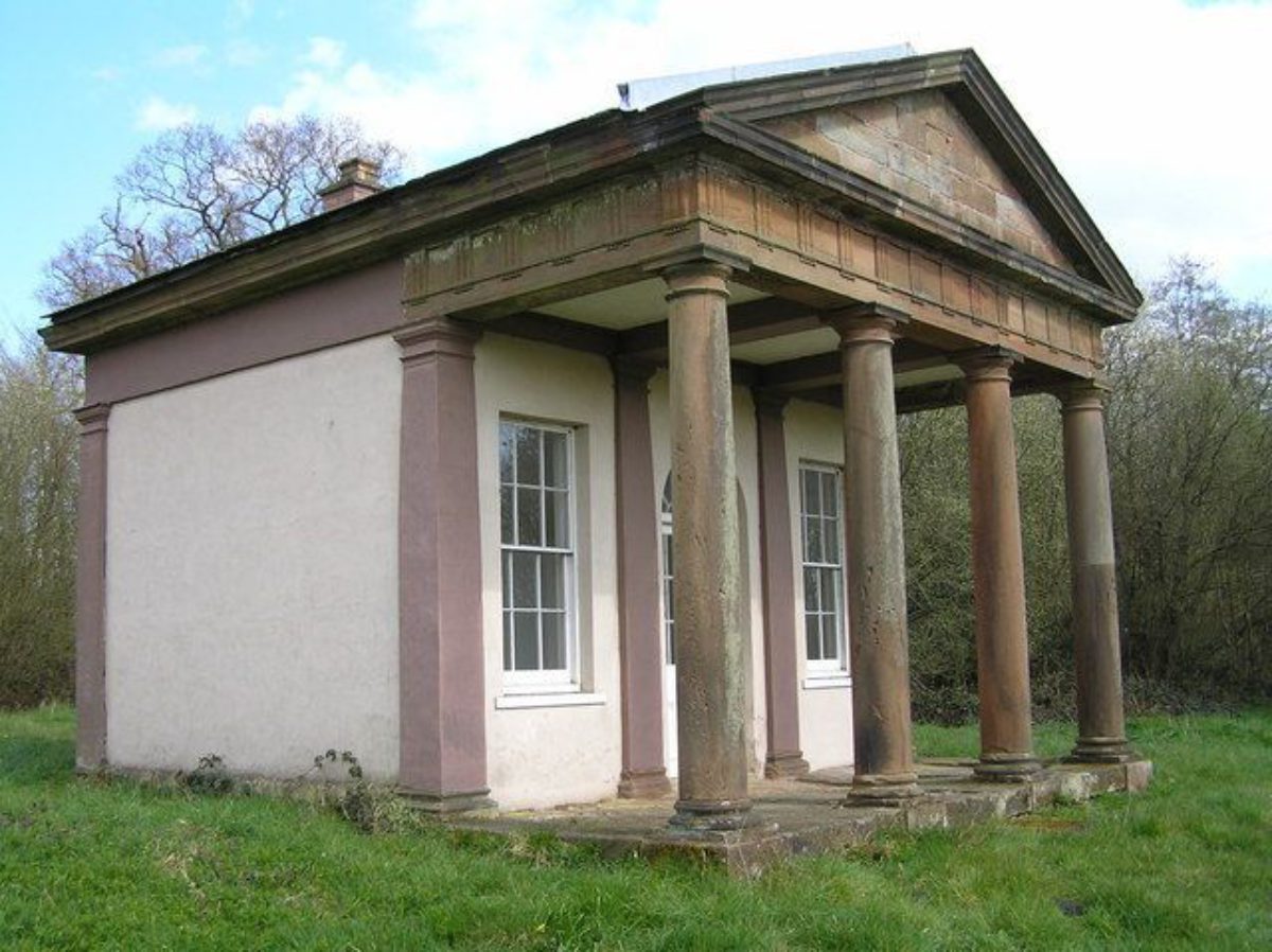
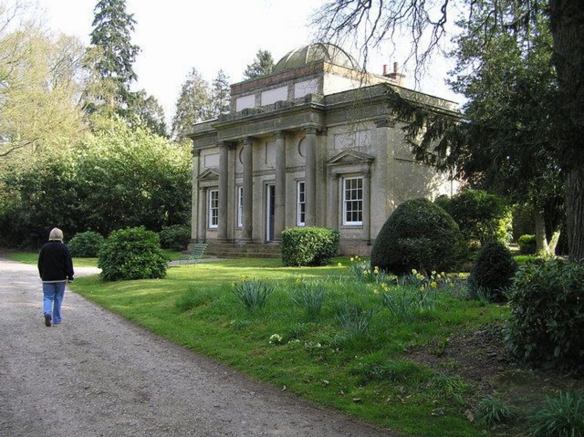
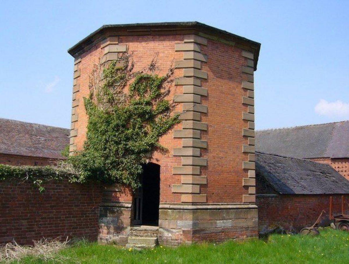
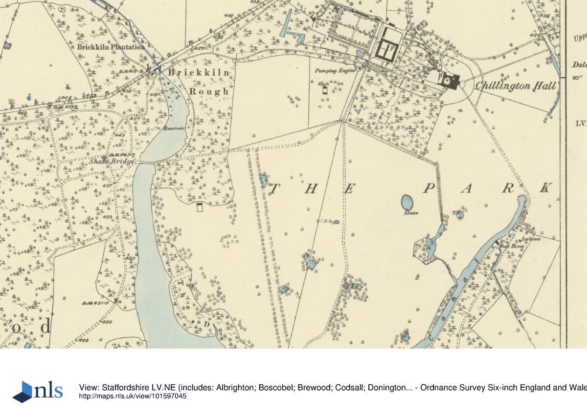
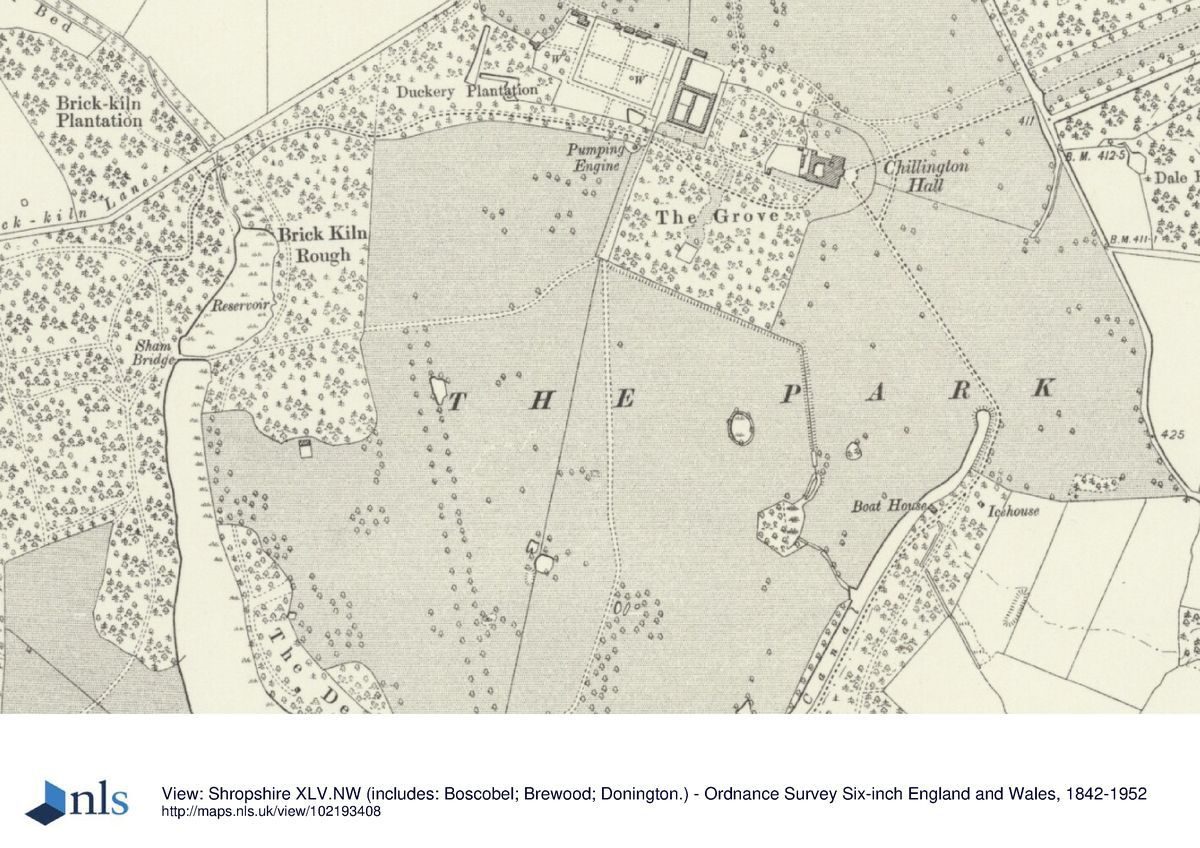
Around The Canal and Pool are a number of high-quality buildings and other features. On the south side of The Canal, and 150m from its north end, is a sluice house (listed grade II). This is a brick building, possibly of the third quarter of the C18, with an elaborate arched entry on to The Canal. It was converted in the C20 from a boathouse. About 70m to the east of the sluice house is an C18 icehouse (listed grade II). At the point where The Pool is entered by the Canal is Payne's Bridge [sic] (listed grade II*), a late C18 stone ashlar bridge by James Paine. On The Pool edge 250m south-west of Payne's Bridge, and surrounded by yews, is the ruinous Gothic Temple, perhaps of c 1772 and built of brick rendered to look like ashlar (listed grade II). Some 300m south-west of the Gothic Temple, and set back c 100m from the edge of The Pool, is the Grecian, or Ionic, Temple (listed grade I). Perhaps designed by Sir John Soane in the 1780s, the Temple is a substantial, five-bay, yellow-brick Ionic building with ashlar dressings, a central portico of four columns, and with a central, leaded, fibreglass dome. It masks a gamekeeper's cottage. Intervisible from the Grecian Temple is the Roman, or Neo-Classical, Temple (listed grade II) of c 1772, which stands on the north-east shore of The Pool. Restored in the 1990s the building has a facade with four Roman Doric columns supporting an entablature; behind is a single room with fireplace. At the northern end of The Pool the water is impounded by a five-arched Sham Bridge (listed grade II*) by Brown. Water enters The Pool from a reservoir above the bridge via a stone culvert.
There is a third bridge, the Holbrook Bridge (listed grade II), over an arm of water leading to the Holbrook Pool on the west side of The Pool. The bridge, late C18 and possibly by Brown, was repaired with blue bricks c 1875.
The main carriage drive circuit runs via the south side of The Canal and Pool, along the dam or embankment which retains the water. From it a view is obtained c 600m south to White House (listed grade II*), to which a Palladian north facade was added as an eyecatcher in the later C18.
Between the Hall's pleasure grounds and The Canal and Pool is permanent grassland with mature parkland trees, some of the oldest specimens (oaks, Scots pines) possibly being surviviors of Brown's plantings of c 1760. In addition to Big Wood, along the north boundary of the park, between Big Wood and the kitchen garden, are woods called The Charlemagne (in 1883 named Brickkiln Rough) and Duckery Plantation. Woodland also extends down the east side of The Pool (The Decoy), and along the south edge of the park, where Old Park Wood forms a south-eastwards extension.
In the 1970s the M54 motorway was driven through the southern part of Big Wood, passing c 100m south of the Grecian Temple.
In 1511 five acres (c 2ha) of arable was inclosed as a park, and in 1650 the pastures at Chillington included the New Park, the Old Park, and the Common Park.
Evidence of Brown's involvement - no plan or accounts are known - comes from a statement by James Paine in 1767 where he speaks enthusiastically of the park, and of The Pool in particular, and refers to Brown 'who designed and conducted the execution of the improvements of this justly admired park' (Stroud 1975, 147). The landscaping was probably completed about 1761, as the improvements are shown on a plan of that date by Thomas White, a 'pupil' of Brown's. Comparison of that plan with one of the early C18 is the best indication of what was done: defining the bounds of the park; removing field boundaries and some buildings; planting clumps and other woodland, and creating The Canal.
KITCHEN GARDEN
The brick-walled kitchen garden lies to the west of the stables and farmyard complex. The main compartment, C18, is c 130m east/west by c 100m north/south. Paths divide the interior, still partly cultivated in 1997, into quarters; some clipped golden yew still survive at the ends of the north/south path. Against the north wall are two early C19 vineries, in 1997 in poor condition. Behind that wall and the vineries are brick sheds. A further brick-walled compartment was built on to the west side of the garden in the early C19, with a gardener's house on the west side. In 1997 the interior of that compartment was grass.
REFERENCES
Country Life, 103 (13 February 1948), pp 326-9; (27 February 1948), p 426
The Victoria History of the County of Staffordshire 5, (1959), pp 28-30
R Sidwell, West Midland Gardens (1981), pp 164-5
Maps
Plan of Hall and Gardens,1756 (private collection)
A Survey of the Lordship of Chillington, early C18 (D590/363 a & b), (Staffordshire Record Office)
Plan of Chillington Manor by Thomas White, 1761 (D590/368), (Staffordshire Record Office)
Plan of Chillington, 1791 (D590/370), (Staffordshire Record Office)
W Yates, Map of Stafford, 1775
OS 6" to 1 mile:
1st edition published 1883
1924 edition
Description written: 1997
Register Inspector: PAS
Edited: September 1999
- Visitor Access, Directions & Contacts
Telephone
01902 850236Access contact details
The site has specific Public Open Days visit the Chillington Hall website for more detailed information.
Owners
The Giffard Family
Chillington, WV8 1RE
- History
The following is from the Register of Parks and Gardens of Special Historic Interest. For the most up-to-date Register entry, please visit the The National Heritage List for England (NHLE):
www.historicengland.org.uk/listing/the-list
HISTORIC DEVELOPMENT
The manor of Chillington has remained in the same family since 1178, which since that time has been known by the name of Giffard. Peter Giffard (d 1746), who inherited in 1718, began the rebuilding of the house and laid out a formal landscape around it, a landscape which was altered considerably in the third quarter of the century when Thomas Giffard (d 1776), who inherited the estate in 1748 two years after his half-brother's death, brought in Lancelot Brown (1716-83) and James Paine (1717-89) to enlarge and alter the park. Giffard's son, also Thomas (d 1823), continued his father's improvements by enlarging the house. Since that time, alterations to both house and grounds have been relatively minor.
Period
- 18th Century (1701 to 1800)
- Late 18th Century (1767 to 1800)
- Associated People
- Features & Designations
Designations
The National Heritage List for England: Register of Parks and Gardens
- Reference: GD2168
- Grade: II*
Features
- Country House (featured building)
- Tree Avenue
- Description: Avenue of oak trees.
- Earliest Date:
- Latest Date:
- Folly
- Description: There are follies in the grounds.
- Lake
- Description: The Pool, a 500m wide lake with a curving, 800m long.
- Canal
- Description: The Canal, a curving, 1.2km long river-like feature.
- Walk
- Description: Estate walk.
- Gateway
- Description: Gateway with four tall, rusticated ashlar piers with ball ornaments flanking a central double cast-iron gate and two single outer gates.
- Building
- Description: A small, red-brick Palladian building.
- Monument
- Description: A wooden cross within the garden marks the site where, c 1510, a panther was reputedly shot by Sir John Giffard.
- Gate
- Description: Another gate with rusticated ashlar piers with ball ornaments, beneath which are the family coat of arms of three stirrups.
- Lodge
- Pavilion
- Description: Central Ionic portico of Tunstall stone and is of two storeys, with end pavilions.
- Kitchen Garden
- Farm
- Description: Large and fine stables and home farm complex.
- Flower Bed
- Description: A geometric arrangement of rose beds with a macrocarpa hedge c 80m.
- Monument
- Description: The Bowling Green Arch, a monumental stone screen with gates believed to be by Robert Bakewell.
- Monument
- Description: A monument to the poet Cowper (who composed a verse about a grove of oak trees planted at Chillington.
- Arboretum
- Description: The Grove, a rectangular arboretum.
- Ha-ha
- Pool
- Description: A 200m long narrow pool.
- Building
- Description: A sluice house. This is a brick building, with an elaborate arched entry
- Icehouse
- Bridge
- Description: Payne's Bridge, a stone ashlar bridge.
- Temple
- Description: A ruinous Gothic Temple, built of brick rendered to look like ashlar.
- Temple
- Description: Grecian, or Ionic, Temple. Perhaps designed by Sir John Soane.
- Bridge
- Description: A five-arched Sham Bridge.
- Bridge
- Description: The Holbrook Bridge, repaired with blue bricks c 1875.
- Specimen Tree
- Description: Oak.
- Specimen Tree
- Description: Scots pine.
- Key Information
Type
Park
Purpose
Ornamental
Principal Building
Domestic / Residential
Period
18th Century (1701 to 1800)
Survival
Extant
Hectares
344
Open to the public
Yes
Civil Parish
Brewood and Coven
- References
References
- {English Heritage Register of Parks and Gardens of Special Historic Interest}, (Swindon: English Heritage, 2008) [on CD-ROM] Historic England Register of Parks and Gardens of Special Historic Interest
- Sidwell, R., {West Midland Gardens: the gardens of Hereford & Worcester, Shropshire, Staffordshire, Warwickshire and West Midlands} (Gloucester: Sutton, 1981), pp. 164-5 West Midland Gardens: the gardens of Hereford & Worcester, Shropshire, Staffordshire, Warwickshire and West Midlands
- Page, W. (ed), {Victoria History of the County of Stafford} (Constable: London, Volume 5 1959), pp. 28-30 Victoria County History: Stafford, Volume 5