Introduction
Berwick Park has an 18th-century park surrounding a house dating from 1731. The site is roughly triangular and lies in a rural setting. Features include a dovecote, 19th-century stables, grass terraces, kitchen garden, parterre garden and a chapel.
The following is from the Register of Parks and Gardens of Special Historic Interest. For the most up-to-date Register entry, please visit the The National Heritage List for England (NHLE):
www.historicengland.org.uk/lis...
18th-century park, surrounding a house of 1731, improved in the late-19th century.
LOCATION, SETTING, LANDFORM, BOUNDARIES AND AREA
Berwick lies approximately 3 kilometres north-west of the centre of Shrewsbury in a loop in the Severn which defines the west and south boundaries of the park. The park lies on level land, which slopes gently down to the river, with the house located to the north-west of the site. The park is bounded to the east by the main Shrewsbury - Baschurch road (B5067) and narrows at its top end, so it is roughly triangular. The park is bounded at its top end by The Grove, a woodland belt, with the settlement of Upper Berwick to the north of this. The park is located within a rural setting; to the south beyond the registered area is low-lying agricultural land, to the west beyond the river the land rises steeply and is a mixture of woodland and agricultural land. The home farm to the north-east of the house is not included within the registered area; the area registered extends to approximately 115 hectares.
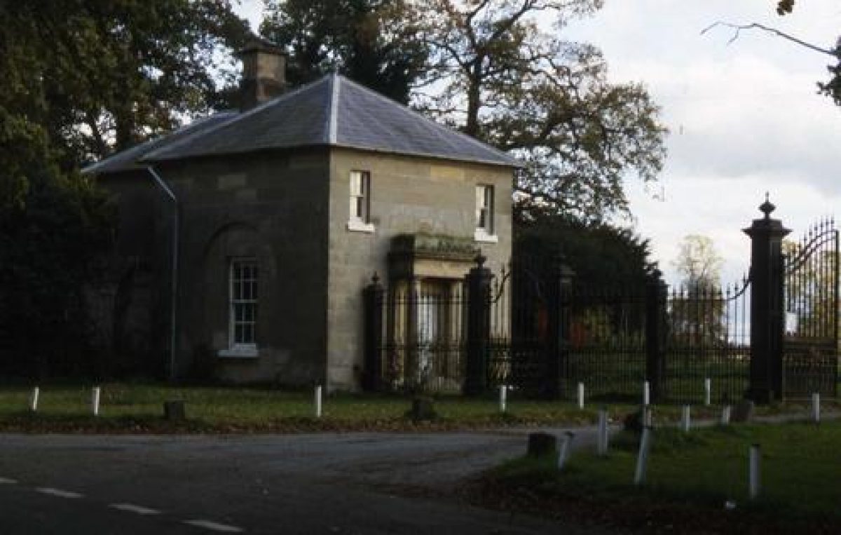
ENTRANCES AND APPROACHES
The main drive to the house enters the east side of the park, from the Shrewsbury -Baschurch Road. The entrance has large iron gates flanked by a pair of late-18th-century grey sandstone ashlar lodges (listed Grade II). The lodges are possibly by Robert Mylne, who carried out alterations to the house in 1780. They were originally single storey and raised to two storeys in around 1878, probably by Stevens of Birmingham. From the lodges, the drive gently curves due east across the former park, now farmland, past both almshouses and chapel towards the south-east front of the house.
A further drive, the Shady Walk, runs in a straight line from the main road (its entrance to the north of the main entrance) south-west to the almshouses. This drive, present as at least a track on a plan of the park of 1802, is lined with Spanish chestnut, these having replaced elms in the 1970s. The track loops around the almshouses and on to the Home Farm.
The area of the park is bounded to the north by a belt of woodland, The Grove. To the north, through this, a drive runs to the Shrewsbury - Baschurch road. In the 19th century a drive branched off this northward to Upper Berwick.
PRINCIPAL BUILDING
Berwick House (listed Grade II*) stands in the north-west part of the site with the river to its rear. It is constructed of red brick with stone dressings and of three storeys and basement. The `fine, festive' (Pevsner) south-east front is of nine bays and looks across the Italianate garden. The south-west elevation was modified in 1878 and looks across a set of terraces leading down to the river. Adjoining the north-east elevation of the service range is a gateway by Robert Mylne and the remains of the around 1730 dovecot (listed Grade II).
Beyond the house, to the north east is a large stable range of 1878, built on the site of what in 1760 was the northern compartment of the kitchen gardens, with a hot house and green house. The around 1730 Home Farmhouse is to the north-east of this (both listed Grade II).
ORNAMENTAL GARDENS AND PLEASURE GROUNDS
South-east of the house is a shallow forecourt bounded by railings and gates of around 1878 (listed Grade II). Beyond this is a slightly sunken Italianate garden of playing card shape. This garden is probably contemporary with the 1878 alterations to the house. It was reputedly laid out under the direction of Mrs. Watson following a visit by the Watsons (who were married in 1856) to Italy. It is enclosed by low brick walls with apsidal projections for seats midway along the sides, and is divided internally into an edged parterre with a central sundial encircled by yew trees. This late-19th-century garden covers the ground occupied in 1760 by a formal garden enclosed by an elaborate heraldic iron screen, probably by the Davies Brothers of Wrexham, and containing a central circular`canal'. It may also encompass the site of a shallower outer court with statues of Mars, Mercury and Venus. The statues do not survive. However, the screen was taken by the Earl of Denbigh upon the sale of Berwick in 1875 and moved to his estate at Newnham Paddox, Warks where they remain (listed Grade I, within a Grade II Registered Landscape). In 1890 the Italianate garden was planted up with alpines and herbaceous shrubs and with some of the beds as rockeries (Gardener's Chronicle).
South-west of the house are four steep grass terraces, descended via a central flight of steps, which drop down to the Severn. The lowest terrace is the largest with symmetrical shaped hedges and traces of circular parterres. A red brick colonnade built around the lowest terrace was there by 1890 and this part of the garden too was probably created or modified in the 1870s, on the site of gardens and walks of 1760. North of the terraces and on the river is a boathouse (not inspected). To the south of the terraces is a further, concave terraced slope, known as the amphitheatre, facing west. Walks lead past this and in to a wooded area on top of the Severn bank, described since 1760 as `The Wilderness'. The wooded area extends to the south as an elongated teardrop and is encircled by a brick-built ha-ha. It contains the kitchen gardens, present in 1802, at its southern end as well as a garden seat seemingly assembled from random pieces of worked masonry and brick and of late-19th century date.
PARK
The park lies to the south, east and north-east of the house. The northern and eastern parts remain as pasture scattered with numerous mature deciduous and 19th-century coniferous and specimen trees. Further away from the house, to the south and west some fields are under arable cultivation. Along the southern border of the registered area is a rectangular tree-belt called Powys Coppice.
The chapel (listed Grade II*) stands approximately 250 metres east of the house within a small, square churchyard. The chapel is not easily visible from the house, masked by trees, but is a focal point particularly from the north and eastern parts of the park. East of the chapel the almshouses (also listed Grade II*) are ranged around three sides of a courtyard, open to the south. 300 metres due north of the almshouses is a rectangular pond, surrounded by young trees, this is marked as fish ponds on the 1847 Tithe map. A further irregular-shaped pond, marked as The Great Pool on the Tithe map, lies 300 metres to the west of this within The Grove.
About 500 metres south-east of Berwick House on a rise in the park is an eye-catcher (listed Grade II), probably of the late-18th century or early-19th century (the building itself present by 1802), in the form of gothicized farm buildings. The remains of the farm buildings are now masked by young trees and scrub.
KITCHEN GARDEN
The kitchen garden lies approximately 300 metres south of the house and is square on plan, enclosed by brick walls. A range of late-19th-century glasshouses stands along the north wall of the garden and the gardener's cottage stands to the other side of this. The cottage is of two storeys, built of red brick with a gabled front elevation and faces north onto a courtyard containing various brick 19th-century outhouses and glasshouses. A square kitchen garden is depicted on this site on the 1802 plan and the cottage, although now much altered, and walled garden may thus be of late-18th-century origin.
REFERENCES USED BY ENGLISH HERITAGE
Blakeway, J.B. History of Shrewsbury Hundred or Liberties (1897) 368-9
Colvin, H. A Biographical Dictionary of British Architects 1600-1840
Gotch, C. A Shropshire Vogue: Notes and Correspondence Relating to Robert Mylne' Typescript c 1972, copy in Shrews. Local Studies Libr.
Jacques, D. Rural Gardening on the Sugnall Demesne. Garden History Vol 9 No. 1. 26-39
Stamper, P. Historic Parks and Gardens of Shropshire. 1996.
Pevsner, N and Newman, J. Buildings of England: Shropshire 2006. 144
The Gardener's Chronicle 7 June 1890, 709
MAPS
Thomas Ansell. A Map of Berwick, the Seat of Tho Powis Esq. with the Gardens and Yard Adjacent. 1760 (copy in Stamper, pg 28)
Rough reduced map of Berwick Estate, the property of Thos. Jelf Powys Esq. 1802. Shrops record office ref: 731/5/3/91
Parish Tithe Map 1847
Ordnance Survey 1st Edition (1881)
REASONS FOR DESIGNATION
Berwick Park is included on the Register at Grade II for the following principal reasons:
* It is a representative example of a C18 park, improved in the late C19, which has survived well.
* Although now overlain, there is clear documentary evidence of the presence of an early-C18 formal garden, possibly associated with Stephen Switzer, which substantially increases the park's historic interest
* The Italianate Garden of c 1878 survives well and this alongside other later C19 improvements to the park enhances the interest of the whole
* Most phases of development are contemporary with existing buildings, many of which are listed and as such there is good group value
- Visitor Access, Directions & Contacts
- History
Thomas Powys purchased the Berwick estate in 1728 (Leighton, 1901: 15). In about 1731 Powys employed Francis Smith to build Berwick House (Pevsner and Newman, 2006: 74). The house replaced an earlier building and stood within a landscaped park. The estate had its own chapel and a U-plan range of almshouses, both dating to about 1672 (Pevsner and Newman, 2006: 74).
Thomas Powys commissioned a set of gates on his acquisition of the estate. The gates were probably by the Davies brothers (Edwards, 1977: 83). Side wickets, probably by Benjamin Yates were added later. When the estate was sold in 1875 the gates were excluded in the sale. Instead they were moved to the Earl of Denbigh's house at Newnham Paddox in Warwickshire (Edwards, 1977: 83).
A map dating to 1760 (Shropshire Record Office, 3790/455) shows the gardens in detail. In front of the house was a raised, flagged terrace and at one side of this was a Yew arbour. Between the terrace and the gates was a walled compartment with a circular pond called 'the Canell'. A broad drive connected the terrace and gates. Where the drive ran around the canal two heart and two fleur-de-lis patterns were worked in to it. Beyond the gates, on the main axis, was a statue of Mars and beyond this lay statues of Venus and Mercury. North-east of the house were stables and a dovecote. The walled garden lay beyond this and included a hot house and greenhouse. Further gardens, including a cherry orchard, lay in front of the walled garden. A wilderness lay to the left of the house along with two buildings, one of which was called the 'Bird Cage'.
James Watson, M.P., purchased the estate in 1875. Watson spent £50,000 in improving the house and grounds (Pevsner and Newman, 2006: 74). Stevens of Birmingham remodelled the house in the Italianate style.
Leach (1891: 1-3) provides a description of the gardens in 1891. A 'pretty' sunken garden was made on the south front of the house with a wall and recesses filled up with seats (Leach, 1891: 1-3). Terraced lawns were also constructed and gravel walks added around the flower beds. At the bottom of the garden slope a red brick colonnade was built. There were also extensive fruit and vegetable gardens (Leach, 1891: 1-3).
The following is from the Register of Parks and Gardens of Special Historic Interest. For the most up-to-date Register entry, please visit the The National Heritage List for England (NHLE):
www.historicengland.org.uk/lis...
HISTORIC DEVELOPMENT
Berwick had a medieval manor with deerpark, although the location of the house and boundary of the park are not documented. The chapel and almshouses at Berwick were built in 1672 for Sir Samuel Jones, a wealthy Shrewsbury Merchant, with estates in Northants and Essex. He had inherited Berwick from his father Isaac Jones, and, dying childless, had bequeathed money for the erection of the chapel and almshouses.
In 1728, Thomas Powys acquired the estate, and the main house was built in 1731 for Thomas Powys, and is attributed on stylistic grounds to Francis Smith of Warwick. A plan of 1760 by Thomas Ansell shows a rectangular courtyard to the south front of the house with canals and circular parterres, lead statuary and elaborate screen at the south end. It is not known who was responsible for these designs although Powys was a subscriber to Stephen Switzer's magazine `Practical Husbandman and Planter'. Switzer (1682-1745) made a tour of the Midlands in 1733 and his account at Hoare's Bank shows that during 1732-3 he received payments from Powys (Jacques, 1981). However, it is not clear for what exactly he was being paid; Switzer was a seedsman, operating from Westminster Hall, as well as publishing numerous pamphlets on horticulture and providing designs and advice on garden layout.
In 1776 Thomas Jelf Powys (the grandson of the first owner) inherited the estate and employed Robert Mylne (1733-1811) in 1780 to alter the house, as well as building an orangery. The lodges were also constructed at this time. A map of around 1802 shows driveways and wooded areas, as well as the walled garden and gothicised farm to the south of the house. The house was altered in 1780 by Robert Mylne, who also built an orangery which linked the house to the around 1730 service range to the north-east. The house was considerably altered in 1878, upon its purchase by James Watson. Watson employed Osborn & Reading who redesigned the south-west and north-west elevations, as well most of the interior. The orangery was demolished and the stable range converted to domestic use.
Thomas Jelf Powys's grandson died childless in 1875 and the estate devolved to Rudolph William Basil, 8th Earl of Denbigh, who shortly afterward sold the estate to James Watson. Watson, a Birmingham businessman and later MP for Shrewsbury, engaged Osborn and Reading (according to Pevsner; although attributed to Stevens of Birmingham in list description) to undertake improvements to the house, including the rebuilding of the south-west front in 1878. Additionally, a large stable range was built to the north-east of the house and the lodges were modified. An Italianate garden was laid out at this time, partly on the site of the early-18th-century formal garden, and terraces were built leading down from the new south-west front of the house to the river. The house remains in the private ownership (2008).
Period
18th Century (1701 to 1800)
- Associated People
- Features & Designations
Designations
The National Heritage List for England: Register of Parks and Gardens
- Grade: II
The National Heritage List for England: Listed Building
- Reference: Ashlar lodges, dovecot, stable block, home farmhouse, gates, eyecatcher
- Grade: II
The National Heritage List for England: Listed Building
- Reference: Berwick House, chapel and almshouses
- Grade: II*
Features
- House (featured building)
- Description: The house is constructed of red brick with stone dressings and of three storeys and basement. The south-west elevation was modified in 1878.
- Earliest Date:
- Latest Date:
- Kitchen Garden
- Description: The kitchen garden lies approximately 300 metres south of the house and is square on plan, enclosed by brick walls. A square kitchen garden is depicted on this site on the 1802 plan.
- Latest Date:
- Gate Lodge
- Description: The entrance has large iron gates flanked by a pair of late-18th-century grey sandstone ashlar lodges. The lodges are possibly by Robert Mylne, who carried out alterations to the house in 1780. They were originally single storey and raised to two storeys in around 1878, probably by Stevens of Birmingham.
- Earliest Date:
- Latest Date:
- Dovecote
- Description: Adjoining the north-east elevation of the service range are the remains of the around 1730 dovecot (listed Grade II).
- Earliest Date:
- Latest Date:
- Stable Block
- Description: Beyond the house, to the north east is a large stable range of 1878.
- Earliest Date:
- Latest Date:
- Gate
- Description: South-east of the house is a shallow forecourt bounded by railings and gates of around 1878.
- Earliest Date:
- Latest Date:
- Chapel
- Description: The chapel (listed Grade II*) stands approximately 250 metres east of the house within a small, square churchyard. The chapel is not easily visible from the house, masked by trees, but is a focal point particularly from the north and eastern parts of the park.
- Drive
- Description: The main drive to the house enters the east side of the park.
- Drive
- Description: A further drive, the Shady Walk, runs in a straight line from the main road. It is lined with Spanish chestnut, these having replaced elms in the 1970s.
- River
- Planting
- Description: Slightly sunken Italianate garden of playing card shape. This garden is probably contemporary with the 1878 alterations to the house. It is enclosed by low brick walls with apsidal projections for seats midway along the sides, and is divided internally into an edged parterre with a central sundial encircled by yew trees.
- Earliest Date:
- Latest Date:
- Terrace
- Description: South-west of the house are four steep grass terraces.
- Parterre
- Description: Traces of circular parterres on the lowest terrace.
- Garden Feature
- Description: A red brick colonnade built around the lowest terrace was there by 1890.
- Latest Date:
- Boat House
- Description: North of the terraces and on the river is a boathouse.
- Amphitheatre
- Description: To the south of the terraces is a further, concave terraced slope, known as the amphitheatre, facing west.
- Wilderness
- Description: Wooded area on top of the Severn bank, described since 1760 as `The Wilderness'.
- Ha-ha
- Description: Brick-built ha-ha.
- Garden Seat
- Description: Garden seat seemingly assembled from random pieces of worked masonry and brick and of late-19th-century date.
- Earliest Date:
- Latest Date:
- Specimen Tree
- Description: Numerous mature deciduous and 19th-century coniferous and specimen trees.
- Pond
- Description: Rectangular pond, surrounded by young trees.
- Pond
- Description: An irregular-shaped pond, marked as The Great Pool on the Tithe map, lies within The Grove.
- Glasshouse
- Description: A range of late-19th-century glasshouses stands along the north wall of the kitchen garden.
- Earliest Date:
- Latest Date:
- Garden House
- Description: The gardener's cottage is of two storeys, built of red brick with a gabled front elevation and faces north onto a courtyard containing various brick 19th-century outhouses and glasshouses.
- Key Information
Type
Park
Purpose
Ornamental
Principal Building
Domestic / Residential
Period
18th Century (1701 to 1800)
Survival
Extant
Hectares
115
Open to the public
Yes
Civil Parish
Pimhill
- References
References
- Paul Stamper {A Survey of Historic Parks and Gardens in Shropshire} (1993) A Survey of Historic Parks and Gardens in Shropshire
- Leach, F, {The County Seats of Shropshire} ([n.p.]: [n.pub.], 1891) The County Seats of Shropshire
- Nikolaus Pevsner {Shropshire (Pevsner Buildings of England)} (London: Yale University Press, 2006) The Buildings of England: Shropshire
- Leighton, Stanley, {Shropshire Houses Past and Present} ([n.p.]: George Bell, 1901) Shropshire Houses Past and Present
- Edwards, Ifor {Davies Brothers, Gatesmiths: 18th Century Wrought Ironwork in Wales} ([Wales]: Welsh Arts Cncl., 1977) Davies Brothers, Gatesmiths: 18th Century Wrought Ironwork in Wales
- {List of Historic Buildings: Shrewsbury and Atcham Borough} List of Historic Buildings: Shrewsbury and Atcham Borough