Introduction
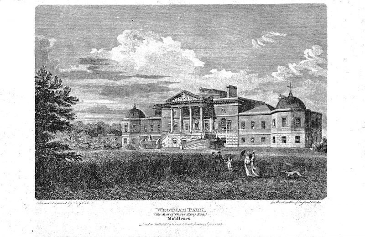
Wrotham Park is a mid-18th century landscape park surrounding a house built in 1754 by Isaac Ware for Admiral John Byng. The house remains in private hands and is used for private functions. The park covers about 116 hectares, surrounded by 1000 hectares of farmland.
Terrain
Two broad, shallow valleys cross the park, rising from west to north-east and west to south-east respectively, from a lake on the west boundary. The house stands on a promontory between the two valleys.
The following is from the Register of Parks and Gardens of Special Historic Interest. For the most up-to-date Register entry, please visit the The National Heritage List for England (NHLE):
www.historicengland.org.uk/listing/the-list
A country house surrounded by an C18 landscape park with work by Lancelot Brown, substantially modified during the later C18 and C19. Early C19 pleasure grounds, laid out in formal gardenesque style, adjoin the house.
DESCRIPTION
LOCATION, AREA, BOUNDARIES, LANDFORM, SETTING
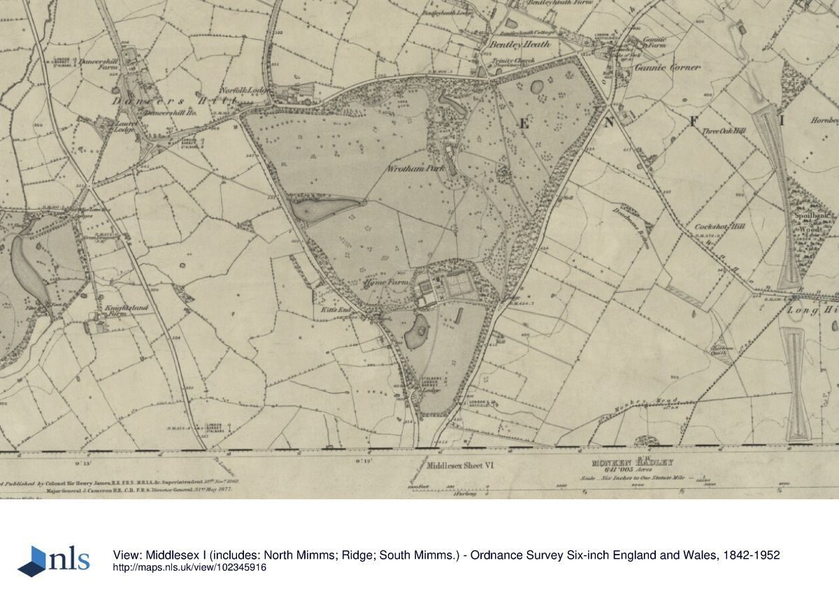
Wrotham Park lies between Potters Bar 1.5km to the north and Barnet 1.5km to the south. The c 116ha site is bounded by public roads, with the A1000 Great North Road to the east, Dancers Hill Road to the north and Kitt's End Road to the west. Two broad, shallow valleys cross the park, rising from west to north-east and west to south-east respectively, from a lake on the west boundary. The house stands on a promontory between the two valleys. The immediate setting is rural, with C20 town development close by to the north, south and south-east. The M25 motorway runs roughly parallel and c 500m north of the north boundary. Long views extend westwards from the house and surrounding grounds across the adjacent countryside.
ENTRANCES AND APPROACHES
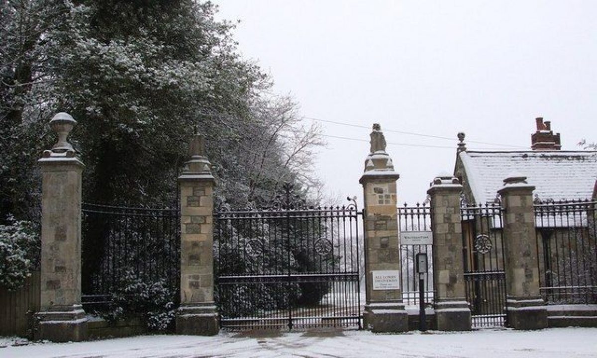
The north drive enters off Dancers Hill Road, 350m north-east of the house, through a curved gateway (probably SS Teulon 1865, listed grade II). Wrought-iron gates and railings are flanked by stone piers, in turn flanked by quadrant walls leading out to further piers. Bentley Heath Lodge (SS Teulon 1865, listed grade II) stands inside the gateway, to the west of the drive, a single-storey stone lodge. From here the drive curves south-west through the park, extending along the east side of the pleasure grounds. The drive passes the service court attached to the north side of the house, arriving at a carriage sweep on the east front, from where a broad flight of stone steps leads up to the central front door.
The south drive enters c 550m south-east of the house, at the London Lodges (late C18 or early C19, possibly Isaac Ware, enlarged late C20, listed grade II), standing either side of the entrance. The two small, square, single-storey stone blocks are linked by railings and two piers. From here the drive curves north-west through the park to the east front. A spur from this entrance leads south-west to the Home Farm and kitchen garden. A further lodge, Kitt's End Lodge (H Clutton 1860, listed grade II), lies 900m south of the house, marking the entrance of a former drive which led directly from Kitt's End Road to Home Farm and the kitchen garden. The two-storey lodge is of polychrome brick with stone dressings.
PRINCIPAL BUILDING
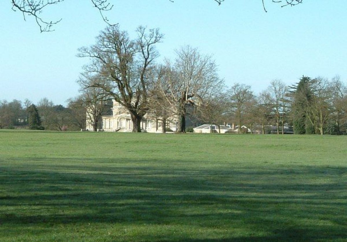
Wrotham Park (Isaac Ware 1754, with alterations of the later C18, C19 and C20, listed grade II*) lies north-east of the centre of the park. The three-storey central block is flanked by wings terminating in octagonal pavilions. The west, garden front is ornamented with a two-storey portico at piano nobile level, onto which the central garden door opens. A curved, stone, two-armed staircase sweeps down from the piano nobile to ground level. This house replaced an earlier one.
The service yard (1810, listed grade II* with the house), including the stables, lies adjacent to the north of the house. The brick stable block is semicircular, with extended arms, and mid C19 low service court additions extending south from this to the house.
GARDENS AND PLEASURE GROUNDS
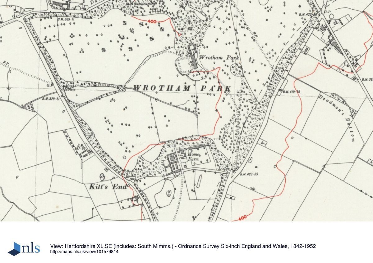
The gardens enclose the house to the west, south and north, extending north into the pleasure grounds. A path runs along the west front, reached from the house via the staircase leading down from the piano nobile, with steps leading down to a rectangular lawn (in the C19 laid out as a rose garden, R Byng pers comm, August 2000) enclosed by further paths, overlooking the park and lake beyond. The south end of the path turns east, extending eastwards beneath the south front, with an informal lawn planted with mature trees to the south.
From the west front the path leads north into the informal pleasure grounds, bounded to the north by Dancers Hill Road. The c 15ha pleasure grounds, planted with mature trees and laid out in gardenesque style, are crossed by a network of paths, with a serpentine lake at the centre. The area is laid out with sunk flower gardens, picturesque tree plantings, collections of exotic plants, shrubberies, ponds decorated with pudding stone and a sunk walk. Formerly a mid C19, iron-framed orangery in Gothic style stood 70m north of the stable block, but this was dismantled in the 1980s. A stone mausoleum (1880, listed grade II) with a domed roof stands 400m north-west of the house, within a railed enclosure. From here a path leads west through the wooded belt enclosing the park.
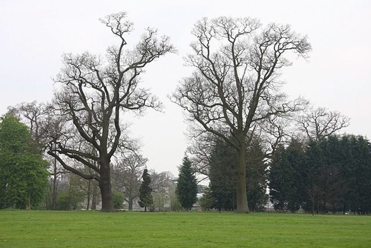
PARK
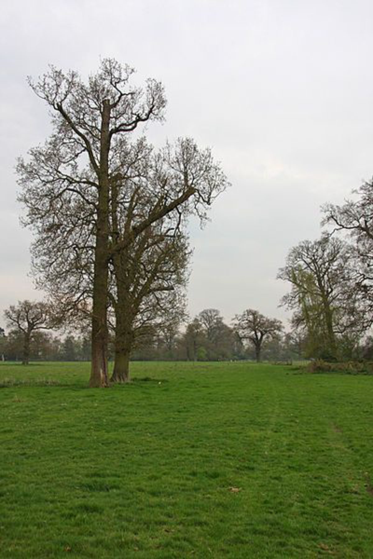
The park is divided into west and east sections by the pleasure grounds and south drive, with a third, southern section lying south of Home Farm and the kitchen garden. It is largely enclosed by belts of trees, through which formerly ran the path from the pleasure grounds encircling the whole park, elements of which still remain (2000). The west and east sections contain single specimens and clumps of mature park trees. The west section, generally sloping down to the west, is dominated by the roughly triangular lake lying adjacent to the west boundary, encircled by the walk from the pleasure grounds.
It appears that during the late C19 and early C20 (OS) the path which extended west and south through the perimeter belts from the northern pleasure grounds continued through the whole of the perimeter belt system, returning to complete the circuit at the north end of the pleasure grounds.
Home Farm (1854, farm buildings listed grade II) lies some 400m south of the house, enclosed by the park, close to the west side of the kitchen garden. Dairy Cottage, Steward's House and Garden Cottage (all 1856, listed grade II) lie between the farm buildings and the kitchen garden, each with brick garden walls enclosing their individual gardens. South of the farm lies the southern section of the park, laid to open arable and enclosed by the perimeter belt planting, with a further lake with an island in the western half.
The east half of the park is laid to pasture and contains many mature parkland trees, with an oval pond at the north side close to a cricket pitch. The western half of this area overlooks the east front of the house below to the west, with beyond this extensive views westwards to distant countryside. An icehouse formerly lay in a circular clump 200m east of the house.
A survey of the old park and gardens was prepared for George Byng by Samuel Lapidge in 1765, Lapidge acting as Lancelot Brown's surveyor. Brown notes that he himself visited the place, but gives no further details (Stroud 1975). A letter of 1773 from Admiral Lord Howe invites Brown to Wrotham as 'my ambition is to benefit by your lights'. A plan of the park before 1780 (Inspector's Report) shows the park largely confined to the area west of a line between the south and north entrances to the park, and north of the kitchen garden. The area was planted with several circular clumps, with belts along the north and south boundaries, and only two clumps on the west boundary. The park enclosed a kidney-shaped pleasure ground to the north, west and south of the house. A small pond occupied the site of the present lake close to the west boundary.
The park was subsequently enlarged in three phases. During the first phase, following the enclosure of Enfield Chase in 1778, George Byng was allotted the area lying to the east of a line approximating to that of the present drive. During the second, early C19 phase, when the park was owned by George Byng II, the highway bounding the north side of the park was diverted to its present position from a point immediately east of Norfolk Lodge Farm to the present Bentley Heath Lodge opposite Bentley Heath Lane. During the third expansion phase, in the second half of the C19, the property then adjoining Wrotham Park to the south was purchased from Mr Barroneau and the substantial house which it comprised was demolished and the present farm buildings erected in its place in 1855 (R Byng pers comm, August 2000).
KITCHEN GARDEN
The square kitchen garden lies 400m south of the house, east of Home Farm, set in woodland to the north and east. It is enclosed by 2(3m high red-brick walls (C18, listed grade II), with openings on the west side. An extensive range of lean-to glasshouses stands on the inside of the north wall.
REFERENCES
Country Life, 44 (9 November 1918), pp 404-9; (23 November 1918), pp 458-66
Victoria History of the County of Middlesex 5, (1976), p 289
D Stroud, Capability Brown (1975 edn), p 245
B Cherry and N Pevsner, The Buildings of England: Hertfordshire (1977), pp 410-11
Wrotham Park: Inspector's Report, (English Heritage 1988)
Maps
An exact plan of the Estate belonging to the Honourable John Byng Esq, Vice-Admiral, situate at Kick's End in the Parish of South Mimms, 1750 (private collection)
Tithe map for Potters Bar parish, 1839 (London Metropolitan Archive)
OS 6" to 1 mile:
1st edition published 1877
2nd edition published 1897
3rd edition published 1919
OS 25" to 1 mile: 1st edition published 1865
Description written: April 1999 Amended: September 2000
Register Inspector: SR
Edited: October 2000
- Visitor Access, Directions & Contacts
Telephone
020 8441 0755Website
http://www.wrothampark.comDirections
South-east of A1M/M25 junction 23.
- History
The following is from the Register of Parks and Gardens of Special Historic Interest. For the most up-to-date Register entry, please visit the The National Heritage List for England (NHLE):
www.historicengland.org.uk/listing/the-list
HISTORIC DEVELOPMENT
Some 150 acres (62.5ha) of the Pinchbank estate were bought by Admiral John Byng (1704-57) in 1750. At this time the house had a walled garden laid out with a formal water feature (estate map, 1750). Byng built the present building on approximately the same site as the earlier house in the mid 1750s, renaming the estate Wrotham Park after the Byngs' earlier home in Kent. The house passed to Admiral Byng's nephew, George (b 1735), who employed Lancelot Brown (1716-83), with Samuel Lapidge as his surveyor, c 1765 to work on the park. Subsequently the park was enlarged in three phases until it had reached roughly its present size by 1840 (Tithe map). The pleasure grounds were laid out in the gardenesque style, possibly as early as 1820 (Inspector's Report), and have since been added to. The landscape has been added to by every generation of the Byng family since it was bought by Admiral Byng (ibid). The estate remains (1999) in private ownership.
- Associated People
- Features & Designations
Designations
The National Heritage List for England: Register of Parks and Gardens
- Reference: GD1168
- Grade: II
Features
- Lake
- Lawn
- Specimen Tree
- Country House (featured building)
- Earliest Date:
- Latest Date:
- Parkland
- House
- Key Information
Type
Park
Purpose
Ornamental
Principal Building
Domestic / Residential
Survival
Extant
Hectares
116
Open to the public
Yes
- References
References
- {English Heritage Register of Parks and Gardens of Special Historic Interest}, (Swindon: English Heritage, 2008) [on CD-ROM] Historic England Register of Parks and Gardens of Special Historic Interest
- Stroud, D., {Capability Brown} (London: Faber, 1975), p. 245 Capability Brown
- Pevsner, N. and B. Cherry, {The Buildings of England: Hertfordshire} (Harmondsworth: Penguin, 1977), pp. 410-1 The Buildings of England: Hertfordshire
- Baker, T.F.T. {Victoria County History: Middlesex, Volume 5} (London: Oxford University Press, 1976), p. 289 Victoria County History: Middlesex, Volume 5
- Related Documents
-
CLS 1/881
Wrotham Park: A Survey of the Landscape, Part 1 - History and Proposals - Hard Copy.
John Phibbs - 1987
-
CLS 1/882
Wrotham Park, Part 2, Vol.1 Field Surveys - Hard Copy.
John Phibbs - 1987
-
CLS 1/884
Wrotham Park, Part 2, Vol.3 Other Studies - Hard Copy.
John Phibbs - 1987
-
CLS 1/885
Wrotham Park, Part 3. Maps, Plans and Photocopies - Hard Copy.
John Phibbs - 1987
-
CLS 1/883
Wrotham Park, Part 2, Vol.2 Field and Documentary Surveys - Hard Copy.
John Phibbs - 1987
-
CLS 1/855A 1-4
Wrotham Park, Maps 1 & 3 The Park/Proposals, Maps 2&4The Pleasure Ground (Comp.7)/Proposals - Hard Copy.
John Phibbs - 1987
-
CLS 1/881