
Introduction
Wilton is an 18th-century landscape garden, with a 19th-century Italian garden. The gardens lie within a park, woodland and agricultural land of some 363 hectares.
Terrain
The northern part of the site is generally level but the ground rises steadily to the south beyond the Nadder.www.historicengland.org.uk/listing/the-list
Details
Wilton contains an extensive and complex garden and park that has remained in the ownership of the Herbert family (the earls of Pembroke) since the mid C16. Over the past 300 years the family has continued to develop the designed landscape at Wilton. Its main phases of development date from the C16, C17, C18, and early C19. These include early C17 works for the second or third Earl of Pembroke by Adrian Gilbert, and for the fourth Earl by Isaac de Caus; early to mid C18 works by the ninth Earl of Pembroke; late C18 works by Sir William Chambers for the tenth Earl of Pembroke; and early C19 works by Sir Richard Westmacott and William Woodcock. During the late C20 further changes were made to the landscape which reflect that whilst continuing to be a private home, Wilton has also become a popular visitor attraction.
Note
This entry is a summary. Because of the complexity of this site, the standard Register entry format would convey neither an adequate description nor a satisfactory account of the development of the landscape. The user is advised to consult the references given below for more detailed accounts. Many Listed Buildings exist within the site, not all of which have been here referred to. Descriptions of these are to be found in the List of Buildings of Special Architectural or Historic Interest produced by the Department of Culture, Media and Sport.
SUMMARY DESCRIPTION
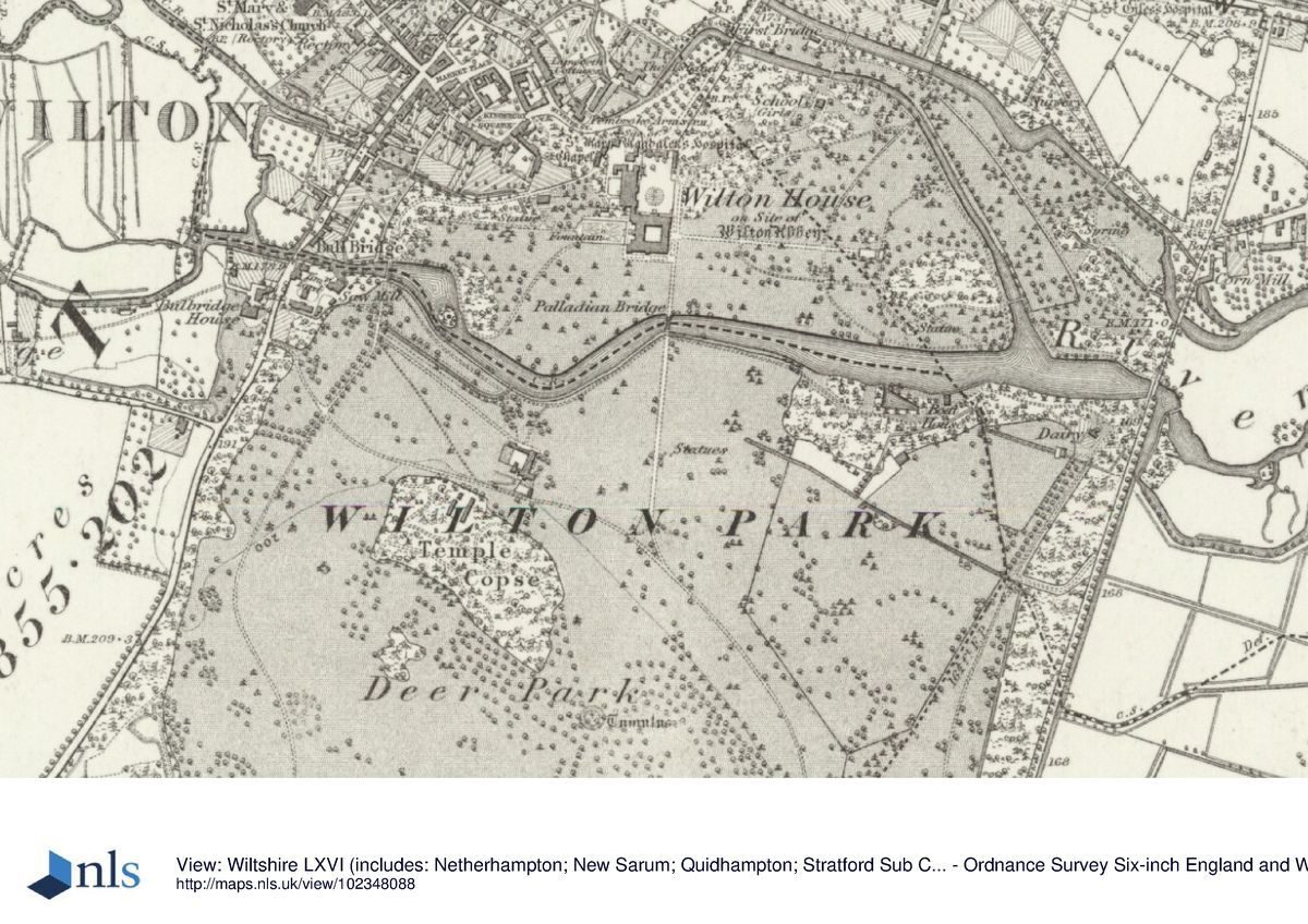
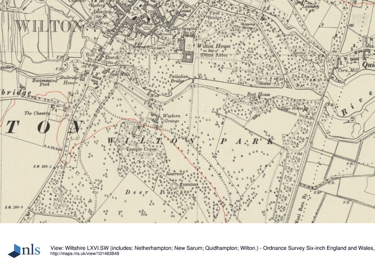
Wilton, a site of c 363ha, lies immediately south of the estate village of Wilton along the A30 and A36, the two roads forming its northern boundary. A mid C18 park wall (listed grade II) encloses the site to the north-west and west. To the east the site is bounded by Netherhampton Road and to the west by South Street, with Bulbridge, a late C20 housing estate, beyond it. To the south the site is bounded by Old Shaftesbury Drove. Wilton House stands in the northern part of the site, which is separated from Wilton Park by the River Nadder. The northern part of the site is generally level but the ground rises steadily to the south beyond the Nadder.
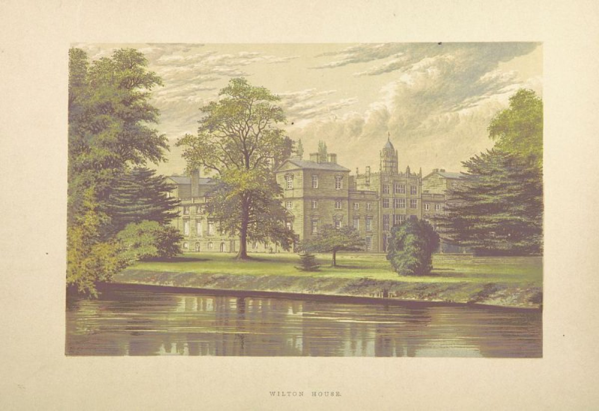
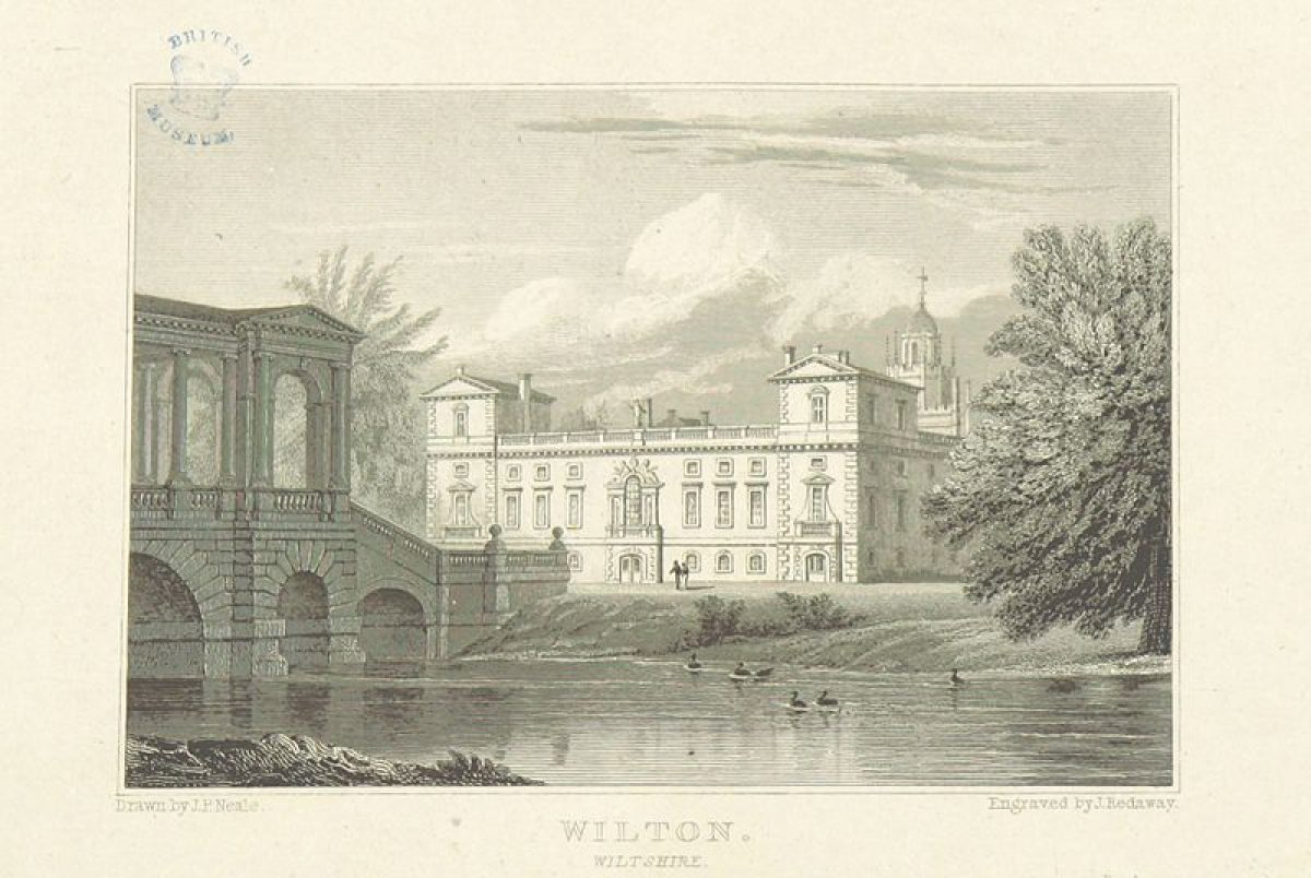
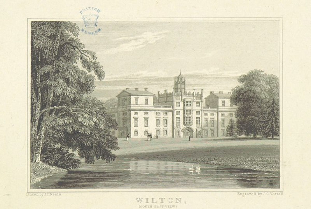
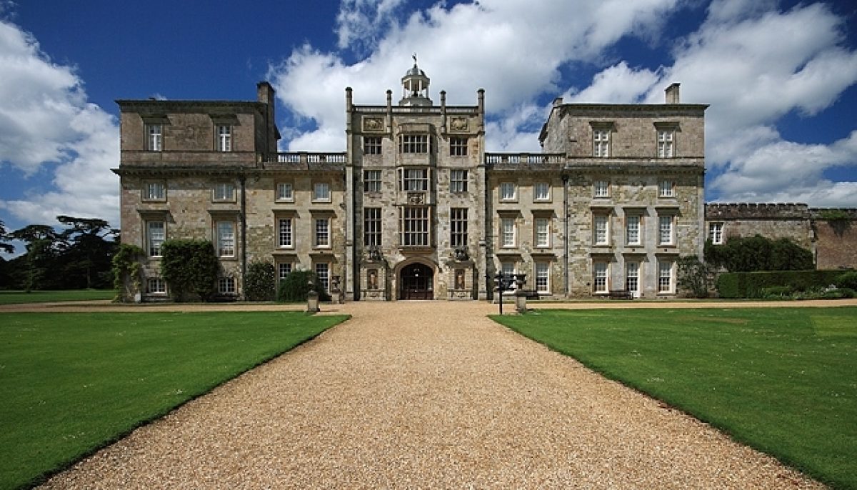
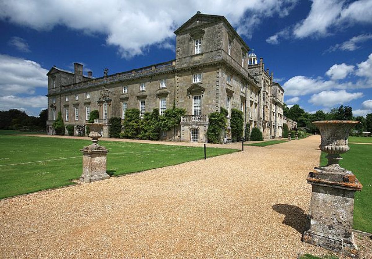
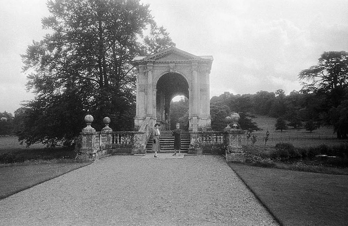
Wilton House (listed grade I) is a courtyard house with a square ground plan. To its north lies a rectangular forecourt enclosed by walls of c 1801 (listed grade II*), and containing a formal garden with a circular fountain designed by David Vicary in 1971. West of the forecourt, attached to the courtyard wall, stands the Riding School of c 1755 (listed grade I). Immediately to the north-west of the forecourt stands a mid C19 former coach house (listed grade II), with c 50m to its west the C14 or C15 Almonry (listed grade I), part of the former medieval abbey at Wilton. The north side of the forecourt is closed by the mid C18 Triumphal Arch with flanking lodges (listed grade I) by Sir William Chambers. Formerly the Triumphal Arch stood south of the House, but it was moved to its current position by James Wyatt c 1801, who also added the lodges. The Triumphal Arch marks the main entrance to the House, which is approached from the north-east via Minster Street (the A30), formerly laid out as an avenue (OS 1887/9).
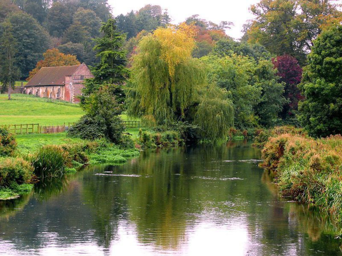
The gardens at Wilton cover an area of c 30ha immediately east, south, and west of the House, and are enclosed by the River Wylye to the north and the River Nadder to the south.
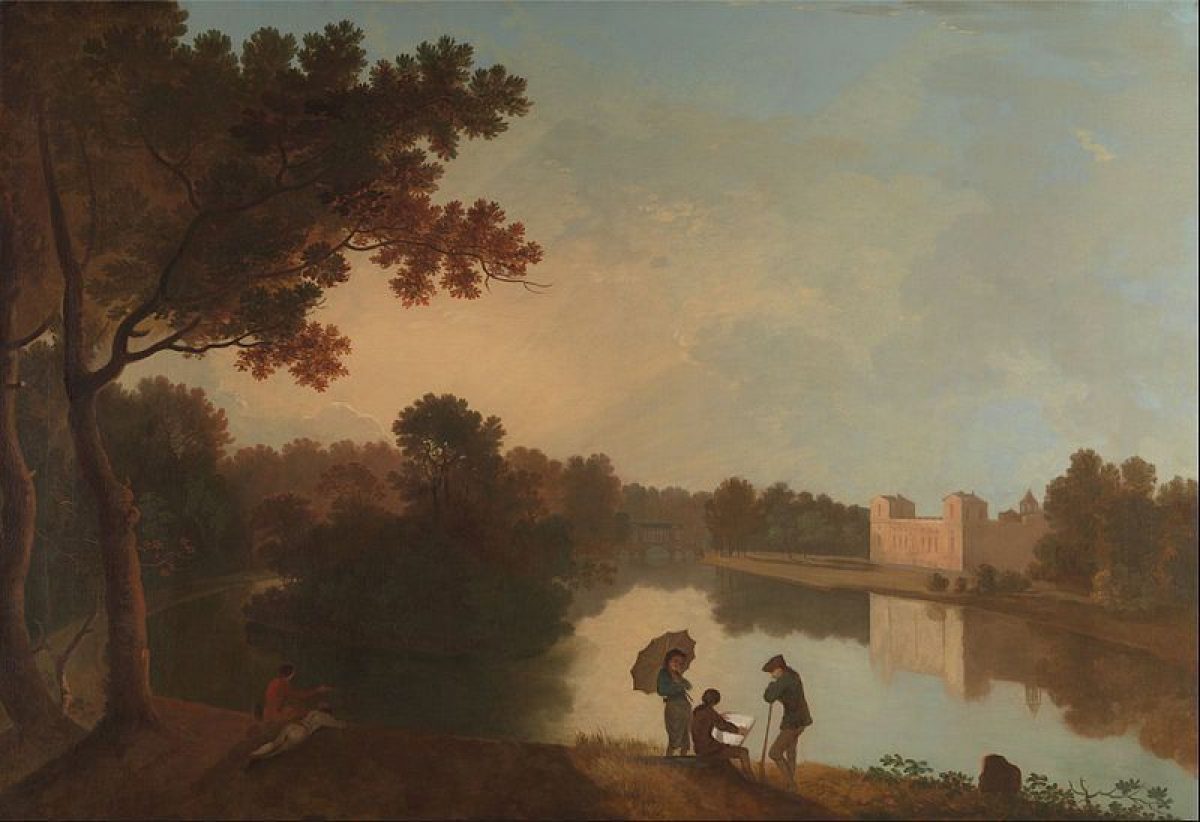
To the west of the House lies the early to mid C19 Italian Flower Garden designed by Sir Richard Westmacott, which is enclosed by low dwarf walls with alternate lead statues and vases (listed grade II). In the centre of the garden, which is laid out with four symmetrical parterres along a central walk, stands a three-tiered fountain (listed grade II as part of the walls). On the north side of the garden, central steps lead up to the early C19 Loggia (listed grade I), which includes carved panels and marble reliefs from a former grotto, part of the early to mid C17 gardens designed by Isaac de Caus. To the north-west of the Italian Flower Garden, c 100m west of the House, stands the Orangery (listed grade II), designed by William Woodcock c 1826. The south-east and south-west corners are flanked by two C17 columns by either Inigo Jones or Isaac de Caus (listed grade II*), brought here from elsewhere in the garden. Immediately south of the Orangery is a swimming pool (late C20), with an early C19 circular fountain (listed grade II) beyond it. Some 250m west of the House, at the end of the central walk that runs through the Italian Flower Garden, stands the mid C16 Holbein Porch (listed grade I). This was moved here c 1800 and is now (2003) used as a garden pavilion. South of the Holbein Porch a path leads for c 100m south-west to the River Nadder. It crosses this via the early C19 Sawmills Bridge and Weir (listed grade II) before leading into Wilton Park south of the river.
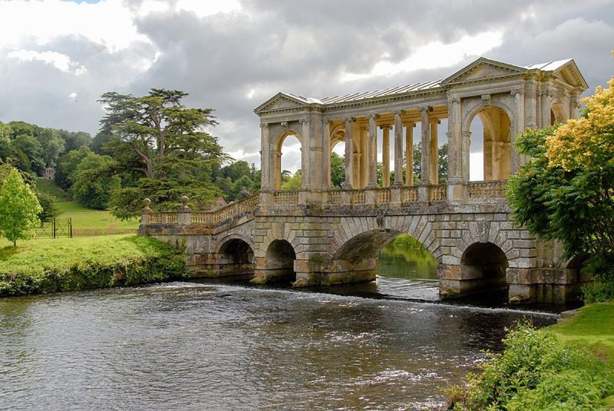
The gardens east of the House are enclosed to the north-east by the River Wylye and to the south by the River Nadder. The layout of this part of the gardens is characterised by a network of minor paths either side of a central walk. The latter starts from the east front of the House and runs c 300m eastwards into the more wooded part of the garden, to the early C19 Whispering Seat (listed grade II). Halfway along this walk stands a water feature by William Pye, introduced in 2001. Some 100m north-east of the House, adjacent to the forecourt, stands an early C19 semicircular stone garden seat. From here a formal walk, lined on either side by ten pairs of early C19 stone vases on pedestals (listed grade II), runs for c 200m southwards along the west front of the House to the River Nadder. Here it continues over the early C18 Palladian Bridge (listed grade I) and leads into the park south of the river. From the bridge there are fine views of the House to the north-west, and the gardens to the east along the north side of the River Nadder, and of the park south of the river. In the wooded part of the gardens, c 300m south-east of the House, stands the C18 three-arched Loggia. The latter stands on an axis with the Egyptian (C3 AD) Column of Venus Genetrix (listed grade I), c 25m to its south-west, and was re-erected here in 1895. Some 250m north-east of the House, surrounded by woodland, stands Park School House (listed grade I). This building probably dates from the C19 and incorporates part of a grotto by Isaac de Caus that was once part of the early C17 garden. A Japanese Water Garden, introduced c 1990, is laid out immediately south-east of the Whispering Seat, c 300m east of the House. A visitor centre with restaurant and adjacent car park (c 0.5ha) is situated immediately adjacent to the forecourt, c 100m north-north-east of the House, with a children's playground c 50m to the south-east (all late C20).
Immediately south of the House is a lawn that slopes gently southwards to the River Nadder. From the House and the lawn are fine views of the Palladian Bridge and the park to the south of the river, including the mid C18 Casino (listed grade I) designed by Sir William Chambers, situated on Temple Copse or Temple Hill c 500m south-west of the House. This wooded hill or mount, a dominant and central feature in the park, has various mature trees and is crossed by a network of paths. During the mid C18 it was laid out as an informal woodland garden, of which the Casino was an important feature. The park covers the southern part of the site, an area of c 180ha, and is surrounded by a thin belt of mature trees. The park rises gently southwards towards Warren Down and is bounded to the south by Hare Warren, a dense woodland plantation. The park is scattered with a mixture of mature tree clumps and single mature specimen trees. In the park, c 300m south-west of the House stands Washern Grange (listed grade I). These stables, probably built in the early C17 and incorporating a C14 barn, were partly rebuilt and partly demolished in the C18. In the north-east corner of the park, along the south shore of the River Nadder c 400m south-east of the House, stands a late C19 boathouse (listed grade II). Some 200m to its south-east stands Daye House (listed grade II), a mid C19 Italianate dairy; the early C19 Dairy Bridge (listed grade II*) crosses the Nadder to its north-east. Home Farm (listed grade II), a mid C19 model farm, is situated on Home Farm Road c 1km south-south-west of the House and is screened to the south-west by Bruce's Hangings, a dense mature woodland plantation. Some 300m to the south-east of Home Farm are The Kennels (OS 1887/9) and c 200m to its north-west the Pembroke Centre (late C20).
The series of walled kitchen gardens (walls listed grade II) covers an area of c 3ha and is situated c 400m north-east of the House, north of the River Wylye. The gardens were formerly approached from the ornamental gardens east of the House via a path leading over two early C19 bridges (listed grade II), one crossing a branch of the River Nadder and the other the River Wylye. Since the late C20 the gardens have been used as a commercial garden centre with adjacent car park, with the main entrance now (2003) along Salisbury Road to the north.
REFERENCES
Note. There is a wealth of published material about this site. The key references are listed below.
Country Life, 4 (10 September 1898), pp 304-07; 15 (28 May 1904), pp 774-87; 95 (21 January 1944), pp 112-15; (28 January 1944), pp 156-9; 133 (9 May 1963), pp 1044-8; (16 May 1963), pp 1109-13; 134 (25 July 1963), pp 206-09; (1 August 1963), pp 264-7
The Studio (1907-08), pls cxxxiii, cxxxiv, cxxxv, cxxxvi
Victoria History of the County of Wiltshire VI, (1962), pp 6-8
B Jones, Follies & Grottoes (1974), p 409
B Cherry and N Pevsner, The Buildings of England: Wiltshire (2nd edn 1975), pp 580-7
D Stroud, Capability Brown (1975), pp 67, 244
R Strong, The Renaissance Garden in England (1979), pp 122-61
J Harris, The Artist and the Country House (1979)
J Bold, Wilton House and English Palladianism (1988)
J D Hunt and P Willis, The Genius of the Place, The English Landscape Garden 1620-1820 (1988), pp 168-9
In Search of English Gardens: The Travels of John Claudius Loudon and his wife Jane (National Trust Classics 1990), pp 155-6
M Batey and D Lambert, The English Garden Tour (1990), pp 55-9
Wilton, A Survey of the Landscape, Management Plan, (Debois Landscape Survey Group 1992)
Wilton House, The Home of the Earl of Pembroke, guidebook, (nd)
Maps
OS 6" to 1 mile: 1st edition published 1887/9
Archival items
I de Caus, Le Jardin de Wilton, c 1645 (Worcester College Library, Oxford)
Aerial photographs, 1999 (NMR18094/04; 18387/10; 18387/12), (NMR, Swindon)
A copy of the Wiltshire Gardens Trust Index is held at the Wiltshire and Swindon Record Office, Trowbridge.
Description written: December 2003 Amended: January 2004 Edited: December 2004 FDM
- Visitor Access, Directions & Contacts
Telephone
01722 746728Website
https://www.wiltonhouse.co.ukAccess contact details
The gardens are open from April to August every day from 11 am, and weekends only in September.
Directions
The site is south of the A36 Salisbury Road, east of Wilton.
- History
The following is from the Register of Parks and Gardens of Special Historic Interest. For the most up-to-date Register entry, please visit the The National Heritage List for England (NHLE):
www.historicengland.org.uk/listing/the-list
HISTORIC DEVELOPMENT
During the C8 King Egbert established a priory at Wilton. The land and manors at Wilton were granted to the church c AD 871 and it became an abbey. In 1542 Henry VIII gave Wilton Abbey and its surrounding land to William Herbert (cr Earl of Pembroke 1551), whose family have owned it since. The first Earl replaced the abbey with a new house, of which only the entrance porch (called the Holbein Porch) has survived, and enclosed a park c 1550. Before 1623, under the ownership of the second or third Earl, Adrian Gilbert laid out gardens and walks. After the third Earl's death in 1630, his brother Phillip (fourth Earl of Pembroke) inherited the Wilton estate. He altered the Tudor-style house c 1632 and laid out formal gardens to designs by the architect Isaac de Caus (de Caus, c 1645). The gardens formed an integrated scheme of parterres and other compartments to either side of a central axis extending from the garden front to a grotto embellished with statuary, waterworks, and joke fountains. In 1647 most of the House was destroyed by fire, and after the death of the fourth Earl in 1650, the fifth Earl of Pembroke commissioned the architect John Webb (1611-72) who completed a new house c 1653. Under the ownership of the fifth Earl, who died in 1669, the park included a grotto, a maze, several fountains, and possibly various new buildings (Debois 1992). Under the sixth and seventh Earls no great changes were made to the House and landscape at Wilton. After the death of the seventh Earl in 1683, the eighth Earl extended the art collection at Wilton considerably. In the early C18 the River Nadder east of the House was canalised, various avenues and walks were planted in the park, and statues and other features were introduced in the gardens. After 1733, under the ninth Earl, the Wilton landscape underwent significant changes. Having a great interest in the arts and being an architect of some importance, the ninth Earl became a close friend of Lord Burlington and William Kent. He removed and relandscaped most of the de Caus formal gardens and widened the River Nadder, over which he constructed a Palladian bridge with the assistance of the architect and clerk of works Roger Morris. By the mid C18 he had planted various avenues, laid out an informal woodland garden on Temple Hill, and introduced various garden buildings and features elsewhere in the grounds. During his period of tenure from 1750 to 1794, the tenth Earl built a riding school c 1755, and between c 1760 and 1774 the architect Sir William Chambers was commissioned to design various new buildings in the grounds, including a Casino and a Triumphal Arch. In 1773 the park was extended to the south by the enclosure of Hare Warren. In 1779 the tenth Earl consulted Lancelot Brown (1716-83), but to what extent his recommendations were executed is uncertain. The tenth Earl was succeeded in 1794 by his son George, the eleventh Earl. Between 1801 and 1811 he altered the House to a design by the architect James Wyatt. During this period, new walks were laid out in the garden, a new kitchen garden was built (now, 2003, a garden centre), and an Italian-style Flower Garden was introduced, designed by Sir Richard Westmacott. At this time the Holbein porch, the only remnant of the first house at Wilton, which had been removed in 1805, was re-erected near the new garden. A loggia and an orangery were added to the Italian Garden c 1826, designed by William Woodcock. During this period the present east wall of Little Park was built and new plantations and belts were created in both Little Park and Hare Warren, by then called Great Park. These changes continued after George's death in 1827 when Robert, the twelfth Earl of Pembroke, inherited the estate. In the mid C19, a new road layout gave Wilton its present approach. After the death of the twelfth Earl in 1862, no great changes took place at Wilton. In 1971, the seventeenth Earl commissioned the landscape architect David Vicary to design a water garden and a new Forecourt Garden dedicated to his father. Since then visitor facilities have been introduced and various additions made to the gardens, including the Millennium Water Feature by William Pye, which frames the Tudor façade on the east front of the House.
Wilton remains (2003) in private ownership.
Period
18th Century (1701 to 1800)
- Associated People
- Features & Designations
Designations
The National Heritage List for England: Register of Parks and Gardens
- Reference: GD1408
- Grade: I
Features
- Pleached Trees
- Description: Limes
- Parterre
- Fountain
- River
- Description: River Nadder.
- Ornamental Bridge
- Boat House
- Column
- Description: Egyptian column
- Loggia
- Pond
- Boundary Wall
- Description: A mid-18th-century park wall.
- Earliest Date:
- Latest Date:
- House (featured building)
- Description: John Webb constructed a new house between 1647 and 1653. Between 1801 and 1811 the house was altered to a design by the architect James Wyatt.
- Earliest Date:
- Latest Date:
- Parkland
- Woodland
- Landscape garden
- Farm
- Key Information
Type
Estate
Purpose
Ornamental
Principal Building
Domestic / Residential
Period
18th Century (1701 to 1800)
Survival
Extant
Hectares
363
Open to the public
Yes
Civil Parish
Wilton
- References
References
- {English Heritage Register of Parks and Gardens of Special Historic Interest}, (Swindon: English Heritage, 2008) [on CD-ROM] Historic England Register of Parks and Gardens of Special Historic Interest
- Jones, B {Follies & Grottoes} (London: Constable & Co., 1953) 409 Follies & Grottoes
- Stroud, D., {Capability Brown} (London: Faber, 1975), pp. 67 and 244 Capability Brown
- Pevsner, N. and B. Cherry, {The Buildings of England: Wiltshire} (Harmondsworth: Penguin, 1975), pp. 580-7 The Buildings of England: Wiltshire
- Harris, J., {The Artist and the Country House} {London: Russell Chambers, 1979) The Artist and the Country House
- Batey, M. and D. Lambert, {The English Garden Tour: a view into the past} (London: Murray, 1990), pp. 55-9 The English Garden Tour: a view into the past
- Strong, R. C., {The Renaissance Garden in England} (London: Thames and Hudson, 1979), pp.122-61 The Renaissance Garden in England
- Crittall, E, {Victoria County History: Wiltshire, Volume 6} (London: Oxford University Press, 1962), pp. 6-8 Victoria County History: Wiltshire, Volume 6
- Related Documents
-
CLS 1/854
A Report on the landscape of Wilton House, Part 2: Photocopies (1800 - 1899) - Hard Copy.
Debois Landscape Survey Group - 1992
-
CLS 1/855
A Report on the landscape of Wilton House, Part 2: Photocopies(20th C) - Hard Copy.
Debois Landscape Survey Group - 1992
-
CLS 1/856
A Report on the landscape of Wilton House, Part 3: Photocopies (1600 -1799) - Hard Copy.
Debois Landscape Survey Group - 1992
-
CLS 1/856/3A and B
A Report on the landscape of Wilton House, Part 1: Description and History, Appendix A: Description, Analysis and Aims - Hard Copy.
Debois Landscape Survey Group - 1992
-
CLS 1/856/2
Temple Copse, Wilton Park: A survey of Temple Park - Hard Copy.
Debois Landscape Survey Group - 1994
-
CLS 1/856/4
Wilton Park Plan 1 Survey of Trees and Field Archaeology. Scale 1:2500 - Hard Copy.
Debois Landscape Survey Group - 1992
-
CLS 1/854