Introduction
Dinton Park is a mid-18th-century landscape park. It was improved in the late 18th, early 19th, and 20th centuries.
The following is from the Register of Parks and Gardens of Special Historic Interest. For the most up-to-date Register entry, please visit the The National Heritage List for England (NHLE):
www.historicengland.org.uk/listing/the-list
A mid-18th-century park improved in the late 18th, early 19th, and 20th centuries, surrounding a house built in 1813-16 on the site of an earlier house.
Location, Area, Boundaries, Landform and Setting
Phillips House, a site of c 60ha, lies in a rural area and is bounded to the east by the village of Dinton. To the north it is bounded by The Hanging, a dense, mature woodland belt planted on the steep hillside that encloses the park. To the west the site is bounded by a woodland called Teffont Common which includes the archaeological remains of Wick Ball Camp, an Iron Age hillfort (scheduled ancient monument). The southern boundary of the site is formed by the B3089 between Salisbury and Hindon. Beyond it to the south lies Dalwood Farm, formerly a model farm belonging to the Dinton estate, and to the south-west lies Park Farm. The north boundary of the site is formed by the road between Teffont Magna to the west and Dinton to the east; beyond this lies further farmland.
The site slopes down gently from the north-west to the south-east towards the course of the River Nadder, which lies c 1km to the south of Phillips House. From the south front of the House there are extensive views in a southerly direction of the park and the farmland and hills beyond it to the south of the B3089.
Entrances and Approaches
The main entrance, created in the early C19, lies c 480m east of Phillips House (Map of Dinton, 1828). It is marked by two square stone gate piers (early C20), with a lodge (listed grade II) to the north-west, the latter a former farmhouse dating from the C17. The entrance gives access to a drive that runs west to the east front of the House.
Formerly, during the early to mid C18, the House was approached from the south-east through a gate situated immediately south of St Mary's church, some 530m south-east of the House. This gave access to a formal avenue that led to the south front of the House (Wapshare, 1746).
Principal Building
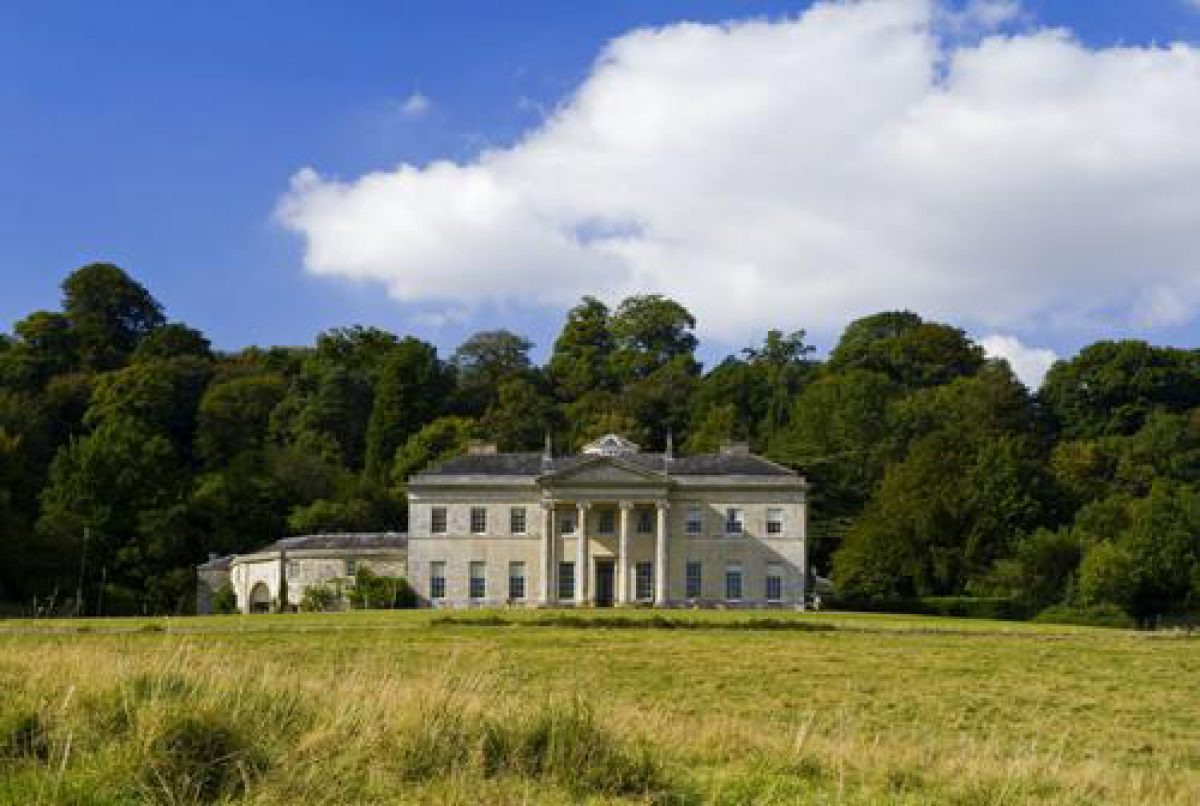
Phillips House (listed grade II*), built in 1813-16 by Jeffry Wyatt, stands in the north-west corner of the site. It is built on the site of a former C17 house known as Dinton House. The two-storey house is built of limestone ashlar and has a hipped roof covered in Welsh slate. The garden front to the south has a classical facade of nine bays, with a central tetrastyle Ionic portico. Attached to the west lies a curved service wing, with a central semicircular alcove with attached seat in the outer wall offering a view of the garden. Attached to the north is a rectangular service courtyard and stables.
Gardens and Pleasure Grounds
The garden, an area of c 1ha, lies immediately south and south-west of the House and is separated from the park by a ha-ha extending for c 200m. The garden is laid mainly to lawn, with a circle of mature laurel in the south-west corner. Wyatt's plan of 1817 shows this area laid out as a formal Flower Garden (National Trust 1994). A mature sweet chestnut tree dating from c 1600 (ibid) stands c 100m west of the House, on the edge of the garden.
During the late C18 a formal garden was situated to the north-east of the House (Andrews and Drury, 1773), nothing of which appears (2002) to have survived above ground (National Trust 1994).
Park
The park extends mainly to the south and east of the House and is scattered with both mature clumps of trees and individual specimen trees, some planted in the late 1990s.
To the east of the park lies Hyde's House (outside the area here registered), which was built in the C18 as the rectory to St Mary's church, Dinton. Hyde's House, with its surrounding Vicarage Paddocks, is screened from the park to the north and west by a belt of mature trees.
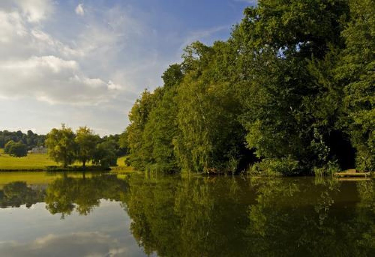
In the far south-east corner of the park lies the triangular lake introduced in late C18 or early C19 which was formed from an existing small pond known as King's Pond (ibid). To the south and east the lake is enclosed by dense woodland including mature oak, beech, and yew. As illustrated by John Britton in his Beauties of Wiltshire of 1825, there was an extensive view from the south side of the lake towards Phillips House to the north-west. This view is now partly obscured by a small island planted with trees situated in the north corner of the lake. The lake was dredged and restored in the late 1990s.
Kitchen Garden
The kitchen garden, now (2002) overgrown, was created in the 1920s and lies on the steep hillside north of the House. It is enclosed to the north by a single brick wall with returns which has a central ornate steel gate leading up to a former orchard, now overgrown. In the north-east corner of the kitchen garden stands an early C20 wooden-framed glasshouse, now ruinous.
REFERENCES
J Britton, Beauties of Wiltshire 3, (1825), p 326
Country Life, 94 (17 December 1943), pp 1080-3
Victoria History of the County of Wiltshire VIII, (1965), p 28
B Cherry and N Pevsner, The Buildings of England: Wiltshire (2nd edn 1975), p 219
Phillips House, Dinton, guidebook, (National Trust 1975)
Dinton Park: Historic Landscape Survey and Restoration Plan, (National Trust 1994)
Maps
W Wapshare, Survey of Dinton, 1746 (Wiltshire and Swindon Record Office)
Andrews and Drury, Map of Wiltshire, 1773 (Wiltshire and Swindon Record Office)
Plan of Dinton showing manor house, park, garden and orchard, 1801 (Wiltshire and Swindon Record Office)
Map of Dinton with Teffont Magna showing house and park, 1828 (Wiltshire and Swindon Record Office)
Tithe map for Dinton parish, 1840 (Wiltshire and Swindon Record Office)
A map of the parish of Dinton and Teffont Magna, 1843 (Wiltshire and Swindon Record Office)
OS 6" to 1 mile: 1st edition published 1890
- Visitor Access, Directions & Contacts
Telephone
0844 800 1895Website
http://www.nationaltrust.org.ukAccess contact details
The park is open daily throughout the year. The house is open on Mondays and Saturdays between April and October. Please see: http://www.nationaltrust.org.uk/place-pages/261/pages/opening-times-calendar
Directions
The site is north of the B3089, 9 miles west of Salisbury.
Owners
The National Trust
Heelis, Kemble Drive, Swindon, SN2 2NA
- History
The following is from the Register of Parks and Gardens of Special Historic Interest. For the most up-to-date Register entry, please visit the The National Heritage List for England (NHLE):
www.historicengland.org.uk/listing/the-list
HISTORIC DEVELOPMENT
In 1689, George South, who owned land in Dinton, sold Dinton House (since 1943 called Phillips House), to William Wyndham of Norrington and Salisbury, whose family owned it until 1916. By the mid-18th century Dinton House was set in a small park with an avenue extending from the south front of the House (Wapshare, 1746). By the late 18th century formal gardens were situated to the north-east of the House, the park had been extended eastwards, and the avenue had disappeared (Andrews and Drury, 1773).
In 1813-16 the Wyndham family built a new house on the site of the old one to a design by the architect Jeffry Wyatt (later Sir Jeffry Wyatville, 1766-1840), which is believed to be based upon Pythouse near Tisbury (Victoria County History 1965). As shown on a design plan by Wyatt of 1817 (reproduced in National Trust 1994), a Flower Garden was planned in front of the curved west wing of the new house. During this period a new approach was created to the east using an existing 17th-century house as lodge, while in the south-east corner of the park an existing pond was enlarged (Map of Dinton, 1828; Tithe map, 1843).
In 1916 the Wyndham family sold Dinton House to Bertram Erasmus Phillips. In the 1920s a ha-ha was constructed to the south of the House, and a kitchen garden was created to the north. Dinton House was let to the YMCA as a holiday home around 1940 and in 1943 Phillips gave the House and park, by then known as Phillips House, to the National Trust, who started a long-term restoration programme. Dinton House and park remain (2002) in the care of the National Trust.
- Associated People
- Features & Designations
Designations
The National Heritage List for England: Register of Parks and Gardens
- Reference: GD2239
- Grade: II
Features
- House (featured building)
- Earliest Date:
- Latest Date:
- Ha-ha
- Earliest Date:
- Latest Date:
- Parkland
- Key Information
Type
Park
Purpose
Ornamental
Principal Building
Domestic / Residential
Survival
Extant
Hectares
83
Open to the public
Yes
Civil Parish
Dinton
- References
References
- {English Heritage Register of Parks and Gardens of Special Historic Interest}, (Swindon: English Heritage, 2008) [on CD-ROM] Historic England Register of Parks and Gardens of Special Historic Interest
- Pevsner, N. and B. Cherry, {The Buildings of England: Wiltshire} (Harmondsworth: Penguin, 1975), p. 219 The Buildings of England: Wiltshire
- Britton, J., {The Beauties of Wiltshire, displayed in statistical, historical and descriptive sketches} (London: Vernor & Hood, 1825), p. 326 The Beauties of Wiltshire, displayed in statistical, historical and descriptive sketches
- Pugh. R.B. and E. Crittall (eds), {Victoria History of the County of Wiltshire} (London: Oxford University Press, Vol. 8, 1965), p. 28 Victoria County History: Wiltshire, Volume 8
- Nicholas Pearson Associates {Dinton & Ladock Historic Landscape Survey/Restoration Plan} (1994) Dinton & Ladock Historic Landscape Survey/Restoration Plan