Introduction
Weston Park has landscape pleasure grounds and a park covering some 400 hectares. It was laid out around 1765 to 1768 by Capability Brown and James Paine, with formal gardens dating from around 1865.
The 17th-century house remains the home of the Earls of Bradford. Brown's grounds are largely intact. Of particular note is the Temple of Diana, by James Paine, and dating back to 1770.
The following is from the Register of Parks and Gardens of Special Historic Interest. For the most up-to-date Register entry, please visit The National Heritage List for England (NHLE):
A landscape park laid out by Lancelot Brown in 1760s around a country house, adjoining which Italianate gardens were devised in the later C19.
Location, Area, Boundaries, Landform and Setting
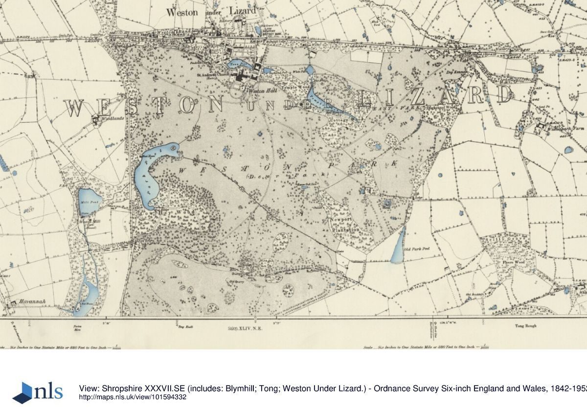
The village of Weston-under-Lizard lies on the A5 (Watling Street) close to Staffordshire's border with Shropshire. The village lies largely on the north side of the road, while to the south is Weston Hall, its service courts and buildings, and its park. That park is an extensive one, extending c 2.5km south of the Hall and measuring the same from east to west, the west boundary being Mill Lane. On the east side the park wall cuts across the landscape following no obvious natural features. The area here registered comprises c 400ha, and essentially represents the park as established in the later C19 following successive extensions to the south.
Entrances and Approaches
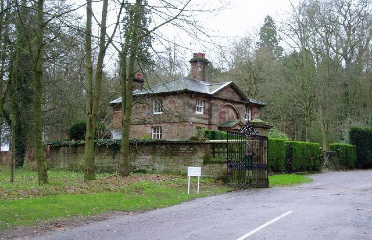
There are several approaches to Weston Hall. The main entrance (later C20) is off the A5 to the north of the Hall, past the Weston lodges, a pair of mid C19 sandstone ashlar buildings with gothic details (both listed grade II). Some 300m to the east of that entrance is a service one to the farm and stables complex (mid C19 gates etc listed grade II), on the west side of which is the Blymhill Lodge (listed grade II), a late C19 red-brick building. Four further lodges, all of sandstone ashlar, stand at more distant entrances to the park, from whence drives run across the park on scenic approaches to the Hall. At the north-west corner of the park is the Shrewsbury Lodge of 1845 and gateway (both listed grade II); at the north-east corner is the mid C19 Stafford Lodge (unlisted); midway down the east side of the park is Brewood Lodge (listed grade II); midway down the west side is the mid C19 Tong Lodge (unlisted).
In 1658, besides the present approach south from the A5, a road to Weston Hall followed the line of the Shrewsbury Walk.
Principal Building
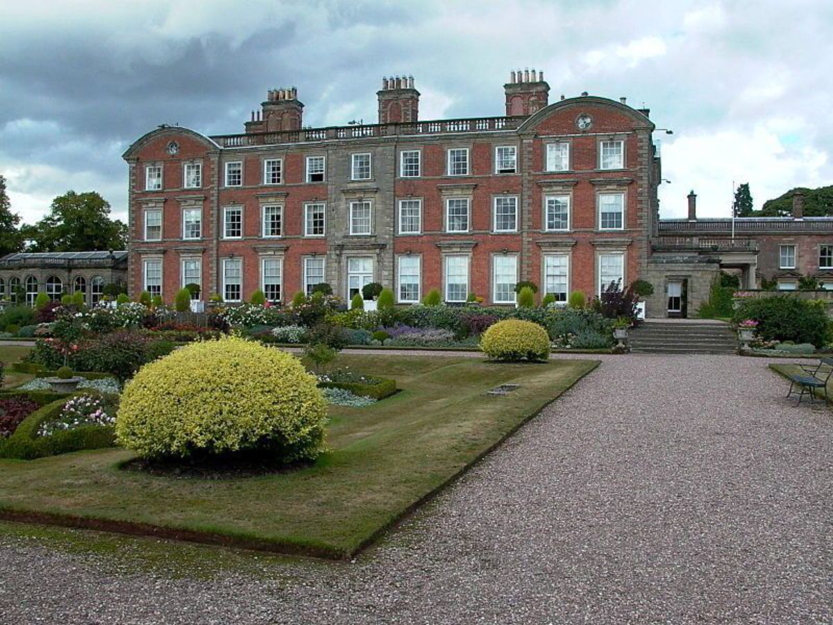
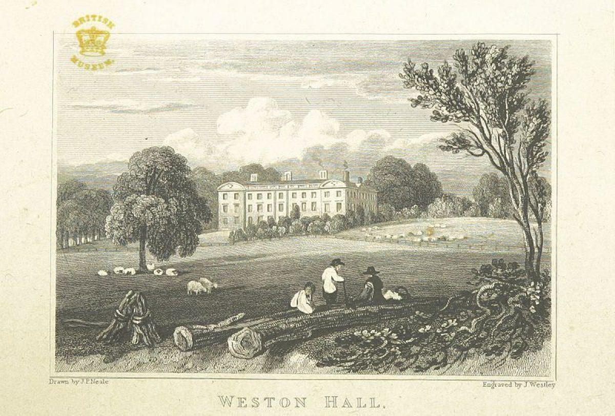
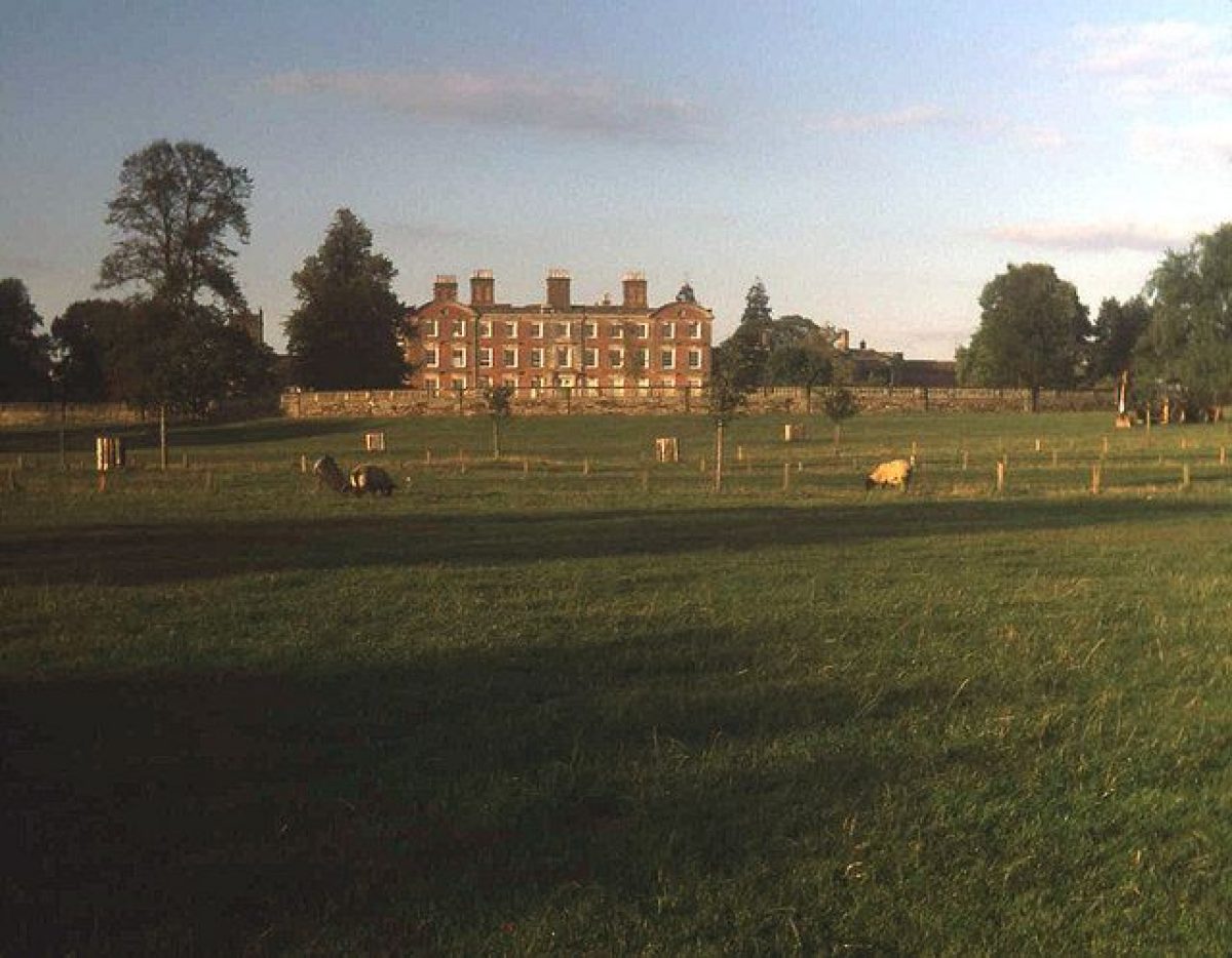
Weston Hall (listed grade I), which lies in the centre of the northern part of the park, was almost entirely rebuilt in 1671 in red brick and stone, with three three-storey ranges enclosing an open courtyard to the north. Substantially this is the building which survives to this day. In the years after 1865 the principal entrance was moved from the south to the east side to which a classical portico was added. At the same time a new wing and an orangery (listed grade II) were built to the west, and the infilling of the courtyard with buildings began.
The parish church of St Andrew lies immediately north-west of Weston Hall, behind and linked to the orangery. To the east of the Hall are brick stables of 1688 (listed grade II), with behind (north) of them large and impressive home farm buildings (listed grade II) of c 1800.
Gardens and Pleasure Grounds
The main formal gardens lie south of Weston Hall. Before the brick-with-stone-detailing south front is an 80m wide, rectangular, terraced and balustraded Italianate garden (listed grade II), with edged flower beds, urns, a fountain, and a circular basin. Linked to the south and projecting into the park is a great semicircular balustraded arc, now (1997) laid down to lawn but when constructed surrounding a mature plane tree. To the west, before the Orangery, is another Italianate compartment. These gardens were formed in several phases in the later C19: Mr Hope, the Head Gardener, laid out a new flower garden to the south of the Hall in 1866; this was incorporated in Edward Kemp's terrace garden of 1877; this in turn was altered in 1887 when the walls were heightened and balustrading added.
The pleasure grounds extend north-west and east of the Hall; the main elements were apparently planned and laid out by Lancelot Brown 1765-8. Extending north-west from the Hall as far as the A5 is the Shrewsbury Walk, a broad gravel walk with lawns to either side and specimen trees including mature sweet chestnuts, perhaps survivals from an earlier, formal layout. The Walk, c 450m long by 50m wide, is bounded to the south by a stone-walled ha-ha, and to the north by a stone wall. Some 300m from the Hall, on the south side of the Walk, is Pendrill's Cave (listed grade II), a C18 cave or grotto said to be the occasional residence in the C18 of Penderell, a mendicant. The Shrewsbury Walk was modified and extended to the newly built Shrewsbury Lodge in 1845.
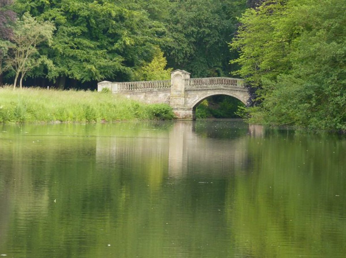
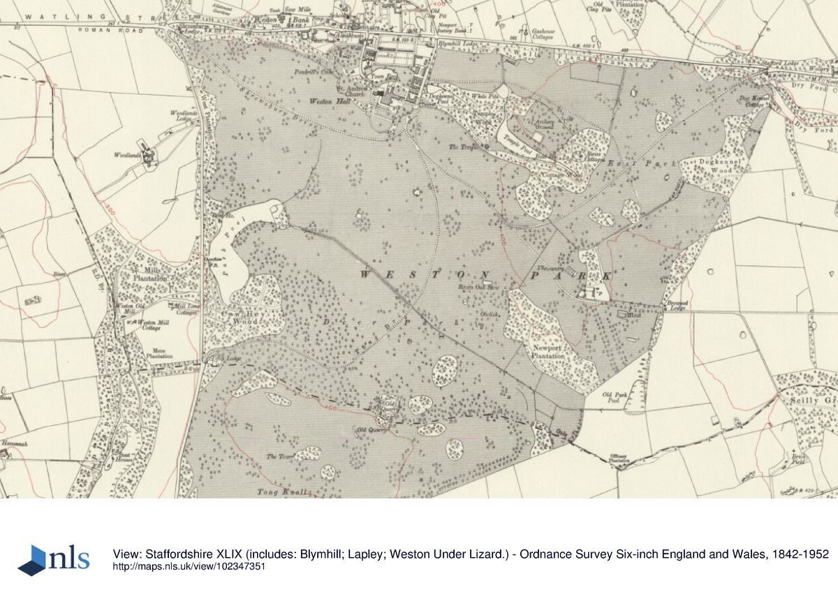
South-east of the stables block the 10m long, late C18 or early C19, Pauslip's Tunnel (listed grade II) leads under a drive and gives access to the eastern pleasure grounds. These, again defined to the south by a ha-ha and overall c 750m long by up to 450m at the east end, were also laid out in the later 1760s by Brown. Walks from the Hall lead through the pleasure grounds, well planted with specimen trees ranging from sweet chestnut (possibly pre-Brown), via Beech (possibly Brown period) to more modern exotics, and around a chain of pools. Much the largest of these is the triangular Temple Pool, created c 1770-91 by an enlargement of the existing Fountain Pool. At the apex of the triangle, to the east, is Paine's Bridge (listed grade I), completed in 1793 to a design by James Paine (1717-89). Close to the north and south ends of the bridge are urns (both listed grade II). Also designed by Paine is the main feature of the pleasure grounds, the Temple of Diana (listed grade I), which stands to the south of Temple Pool overlooking the park. Constructed c 1770 the Temple is of ashlar with a glass dome above, and comprises a three-bay orangery to the front (south), a tea room, a music room, and basic accommodation. Two Coade stone urns and a basin to the south (listed grade II) are of c 1800. The other main structures in the east pleasure grounds are the Ionic Aedicule, a stone seat of 1938 at the west end of Temple Pool; Swiss (or Pink) Cottage (listed grade II) at the east end of the pleasure grounds, reconstructed c 1870 (when a rose arbour was erected in its garden) from a cottage already present in 1806; a mid C19 sandstone boathouse (possibly that built 1837; listed grade II) midway along the south side of Temple Pool; and a Pulhamite rockery at the north end of the Pool.
A miniature railway runs along the north side of the east pleasure grounds, and there is an adventure playground to the ground's north-west.
The two contracts for Brown's works at Weston (1765, 1766) mention a number of existing park and garden features, most of which disappeared over the next few years: the Square Pond; the Fountain Pool; the East Avenue; and a Bowling Green. Precisely what Brown actually designed is uncertain, although there seems little doubt that the general outlines of the two pleasure grounds and their main features were designed by him, even though Paine was brought in as the main architect.
Park
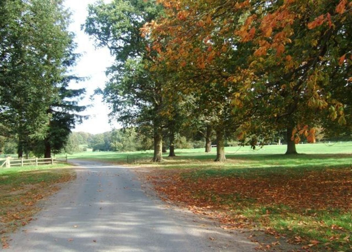
The park at Weston is roughly triangular. The A5 (Watling Street), which here runs almost due west/east, forms the 2.5km long northern boundary to the park the whole circuit of which is walled. The west side of the park, of about the same length, runs north/south alongside Mill Lane, the minor road to Tong Norton. Broad plantation belts screen these roads from the park within.
The Hall lies in the centre of the northern part of the park, looking south across permanent pasture with specimen trees and clumps falling for c 1km to a drain which carries water south-east to north-west across the centre of the park to the 500m long Park Pool (created 1828-9) which lies on the west side of the park north of Tong Lodge. A late C19 boathouse and cottage (both listed grade II) in Swiss Cottage style stand on its west side. Extending around the south side of the Pool is Cow Hey Wood, while adjoining the east side of the park at about the same distance from the Hall is Newport Plantation. North-east of that plantation is The Pheasantry, a mid C19 timber-framed estate cottage (listed grade II), to the south-east of which is the Head Keeper's Cottage. That is approached from the south by an oak avenue planted c 1870. Some 350m south-west of The Pheasantry is a 10m high, late C18 obelisk (listed grade II).
North of The Pheasantry the compartment known as the East Park, to the north and east of Temple Wood, was largely under arable cultivation in 1997.
South of the drain leading west to Park Pool the ground rises up onto Tong Knoll, on top of which is the four-storey Knoll Tower built in 1883. About 500m west of the Tower, against the park wall, is Knoll Lodge, built c 1870 about the time much of the Knoll was planted with trees.
There was deer park at Weston by 1346, east of the later landscape park although extending into its area. A moated site (scheduled ancient monument) 150m south-east of the Pheasantry may mark a lodge site. The 'Old Park' was still a discrete entity in 1775, although by then it was conjoined to the west by 'Weston Park', the landscape park associated with the Hall. That was created at about the time of, and presumably in association with, Brown's work on the pleasure grounds and the Hall's surrounds in the later 1760s. In 1857 the second Earl of Bradford purchased the Tong estate, which enabled the park to be extended to the south by c 1km, to take in the high ground rising up to Tong Knoll, itself bought in 1867 as part of a second round of land purchases in Tong.
Kitchen Garden
The walled kitchen garden (listed grade II), c 150m east/west by 120m north/south, lies north of the Hall and with the A5 as its northern boundary. It is probably of the later C18, and may have been constructed on Brown's advice; building work is recorded in 1770. Running from east to west across the centre of the gardens is a heated wall with pavilions, boiler houses and sheds. In 1992 the south side of the garden was leased to rose growers; the north side was not in cultivation.
Maps
- Map of Weston, nd, (c 1770) (Staffordshire Record Office)
Description written: 1997
Register Inspector: PAS
Edited: September 1999, January 2023
- Visitor Access, Directions & Contacts
Access contact details
The site is open on selected days between March and August. For more detailed visitor information visit the Weston House website.
Directions
This site is in Weston-under-Lizard, on the A5 between Cannock and Telford.
Owners
The Weston Park Foundation
Weston Park, TF11 8LE
- History
The following is from the Register of Parks and Gardens of Special Historic Interest. For the most up-to-date Register entry, please visit The National Heritage List for England (NHLE):
15th - 17th Century
Between the C15 and the C17 the manor of Weston was held by the Myttons. It was the heiress Elizabeth Mytton, who inherited in 1638 and in 1651 married Sir Thomas Wilbraham, who was apparently responsible for the rebuilding of the house from 1671 and later the adjoining parish church. They left no sons, and the estate passed by marriage to the Newport, later Bridgeman family.
The house (which remains the home of the Earls of Bradford) dates from 1671, and the grounds were designed by Lancelot Brown around 1765, around the time he was also working on estates at Tong and Chillington.
18th Century
After the property was assigned in 1763 to Sir Henry Bridgeman, later Baron Bradford, he spent over £12,000 on improvements to the house, grounds and home farm buildings, bringing in, among other contractors, Lancelot Brown (1716-83).
19th Century
A later major phase of alterations to the house and grounds was undertaken by Orlando, third Earl of Bradford, who succeeded in 1865.
20th Century
The estate remained in the family in the later 1990s, although in 1986 the house, garden and park were vested in the Weston Park Foundation in order to ensure their conservation and their presentation to the public. The grounds have been open to the public since 1964.
21st Century
Weston Park is owned and maintained by the Weston Park Foundation, an independent charitable trust.
- Associated People
- Features & Designations
Designations
The National Heritage List for England: Register of Parks and Gardens
- Reference: GD1352
- Grade: II*
Features
- Tree Avenue
- Garden Terrace
- Planting
- Description: The Broderie Italian Garden.
- Conservatory
- Orangery
- Ornamental Bridge
- Earliest Date:
- Latest Date:
- Pool
- House (featured building)
- Earliest Date:
- Latest Date:
- Temple
- Description: Temple of Diana.
- Earliest Date:
- Latest Date:
- Key Information
Type
Park
Purpose
Ornamental
Principal Building
Civil
Survival
Part: standing remains
Hectares
382
Open to the public
Yes
Civil Parish
Blymhill and
- References
References
- Stroud, D.{Capability Brown}, (1975) p148-9. Capability Brown (Country Life article)
- {English Heritage Register of Parks and Gardens of Special Historic Interest}, (Swindon: English Heritage, 2008) [on CD-ROM] Historic England Register of Parks and Gardens of Special Historic Interest
- Sidwell, R. {West Midland Gardens}, (1981) p155-7. West Midland Gardens: the gardens of Hereford & Worcester, Shropshire, Staffordshire, Warwickshire and West Midlands
- Allan, M {Fisons Guide to Gardens in England, Ireland, Scotland and Wales}, (1970) p 284-5. Fisons Guide to Gardens in England, Ireland, Scotland and Wales
- Midgley, L. M {Victoria County History: Stafford, Volume 4} ([n.p.]: [n.pub], 1958), pp. 170-3 Victoria County History: Stafford, Volume 4
- Vol 98, (9 November 1945), pp 818-21; (23 November 1945), pp 910-13 Country Life
- Elizabeth Banks Associates Ltd (1992) Weston Park, Weston-under-Lizard, Shifnal. Landscape Restoration Plan, Phase I (Draft)
- Related Documents
-
CLS 1/387/2
Landscape Restoration Plan, Phase 1 - Digital copy
Elizabeth Banks Associates - 1992
-
CLS 1/388/1
Landscape History to accompany preceding document - Digital copy
Elizabeth Banks Associates - 1993
-
CLS 1/1059
Outline Landscape Management Plan - Digital copy
The Landscape Agency - 2013
-
CLS 1/387/2