Introduction
Warnford Park is a park and pleasure grounds surrounding a country house (demolished). It was laid out primarily in the mid-18th century, possibly with the involvement of Lancelot Brown.
Terrain
To the west the land rises up to Beacon Hill, while the parkland extends south-westwards over gently rolling land in the direction of Old Winchester Hill.The following is from the Register of Parks and Gardens of Special Historic Interest. For the most up-to-date Register entry, please visit The National Heritage List for England (NHLE):
A mid C18 landscape park and pleasure grounds designed as the setting for a country house, possibly with the involvement of Lancelot Brown.
Location, Area, Boundaries, Landform and Setting
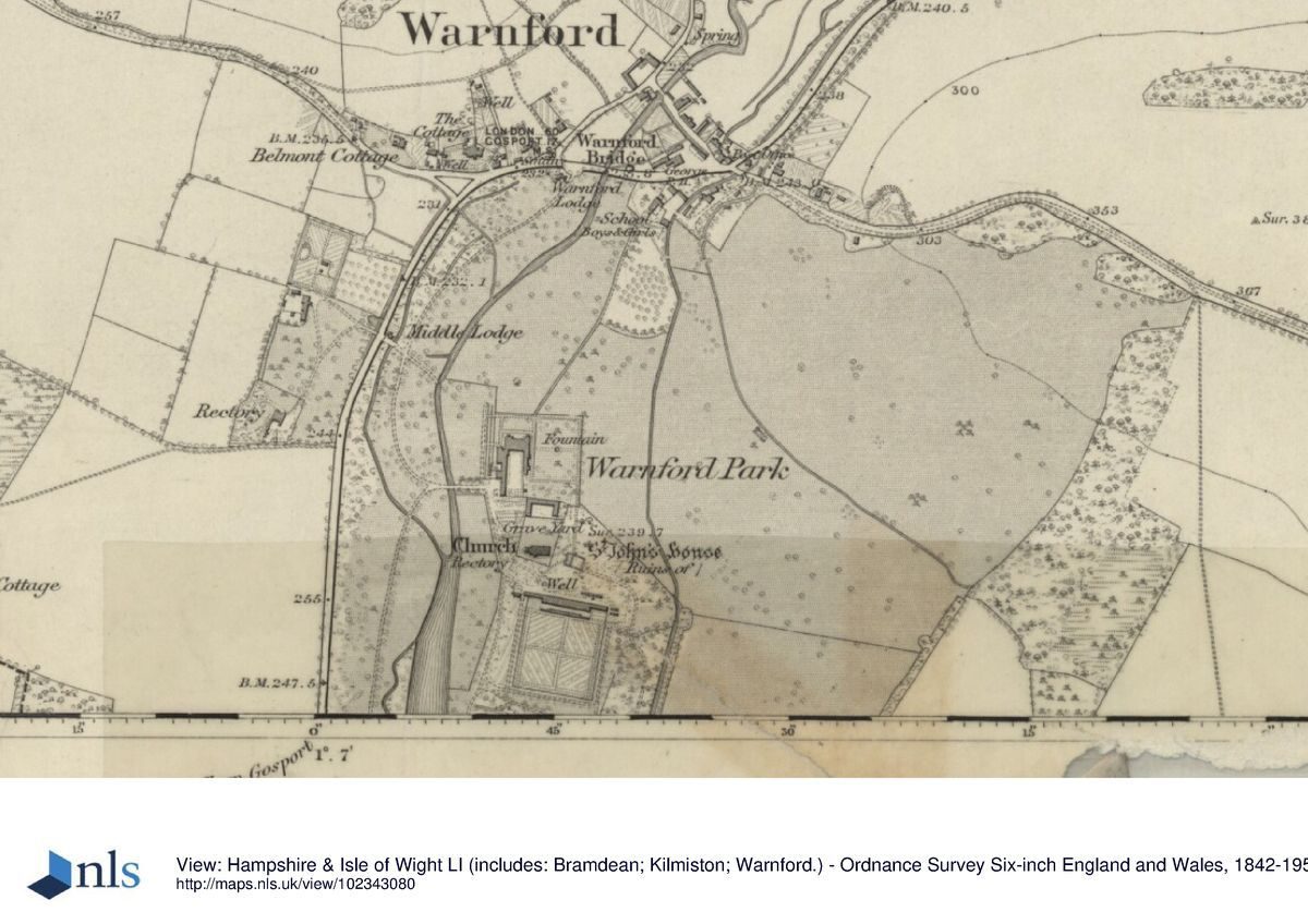
Warnford Park lies nearly 16km south-east of Winchester, on the south side of Warnford village. The A32, Portsmouth Road marks the west and north-west boundaries of the park, while Peake New Road which leads roughly west to east from Beacon Hill Lane to Peake Farm forms the southern boundary. The eastern boundary of the park lies adjacent to open farmland and is defined by a perimeter belt. The Warnford to East Meon road forms the north-east boundary of the park.
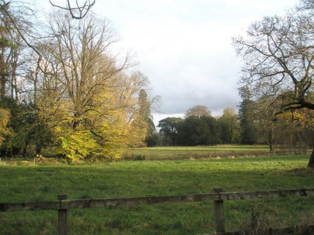
Warnford lies in the heart of the Meon Valley, straddling the river which runs roughly north to south through the park and village. To the west the land rises up to Beacon Hill, a significant local landmark on the Hampshire Downs, while the parkland extends south-westwards over gently rolling land in the direction of Old Winchester Hill, another significant feature.
Views to this outer landscape are now limited due to the mature trees which extend across the valley floor. To the east, the land rises gently with parkland views, the perimeter parkland belt in mid-distance and the downland rising up to form the backdrop beyond. To the south, the Bath House and terrace walk command views out over a level meadow, again with views to the hills beyond (now partially obscured by vegetation). Beacon Hill forms a prominent feature in glimpses through the western shelter belt.
Entrances and Approaches
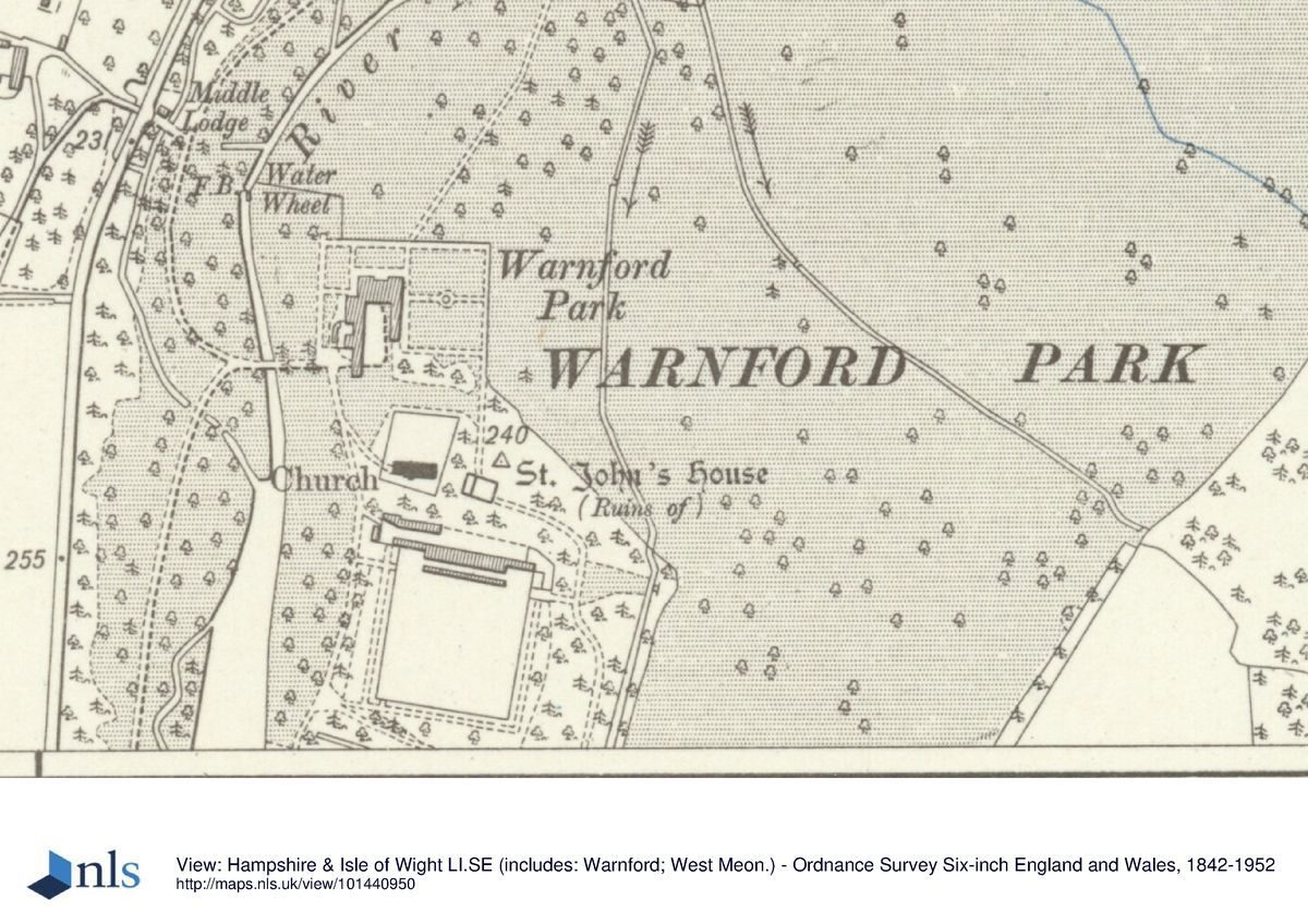
The main entrance to the site lies at the north-west corner of the park in Warnford village, some 80m west of Warnford Bridge. Here the entrance leads through an ornamental gateway set with gate piers and gates, the piers dressed with square-knapped flints and crowned with carved stone vases (mid C19, listed grade II). To the south of this entrance stands Warnford Lodge (mid C19, listed grade II), a Tudor-style lodge with a gothic porch and ornamental bargeboards. From here the drive leads southwards, running within the wooded perimeter belt which screens the public road to the west and the River Meon to the east. The drive passes Middle Lodge, screened to its west, before curving round eastwards to cross the river via a bridge (restored 1990s) to arrive at the site of the west front of the house where now only the house platform remains.
This drive was laid out between 1839 (Tithe map) and 1870 (OS). Prior to this the main approach led into the park from some 80m east of Warnford Bridge, by a lodge (now the site of Manor Farm), and ran south alongside the river, on its east bank and on the line of the old Portsmouth Road (Estate map, 1811; Tithe map, 1839). The drive continued south of the mansion to lead around the southern end of the lake to the south-west gate. In c 1790 the Portsmouth Road (now the A32) was diverted west to its present alignment. The line of the old road remains clearly visible, running close by the site of the west front of the mansion house.
Another entrance leads from the south-west gate and, like the main approach, leads along the western edge of the park and within the wooded perimeter belt which screens the public road to the west. As it leads northwards to join the drive leading in from the village there are views eastwards over to the river. The drives meet at the bridge leading to the west front. Middle Lodge stands midway along the western park boundary, on the A32. Originally one of the main entrances to the park, it dates to the relocation of the main Portsmouth Road and provided an entrance directly off the main road, running for a short distance over the river to the west front of the house.
Principal Building
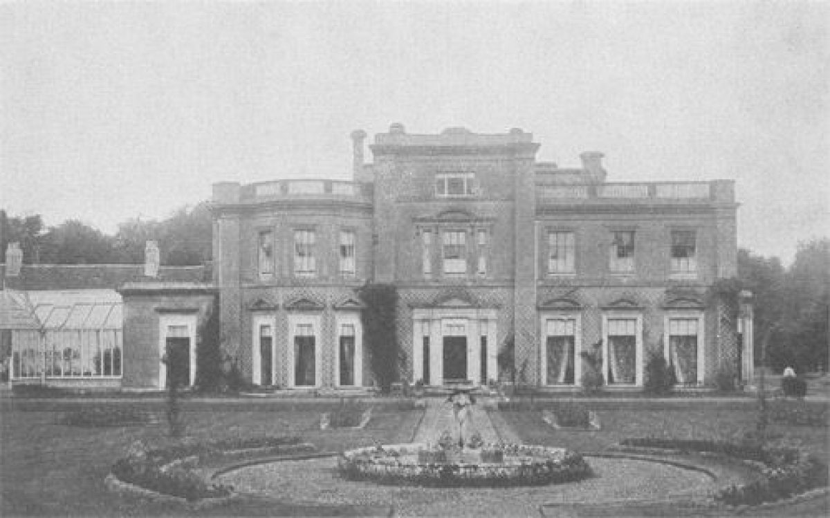
Warnford House, demolished in the 1950s, stood towards the west side of the park. It was extensively altered by Tunno in the mid 1840s and was oriented north to south. The entrance front lay on the west side of the house.
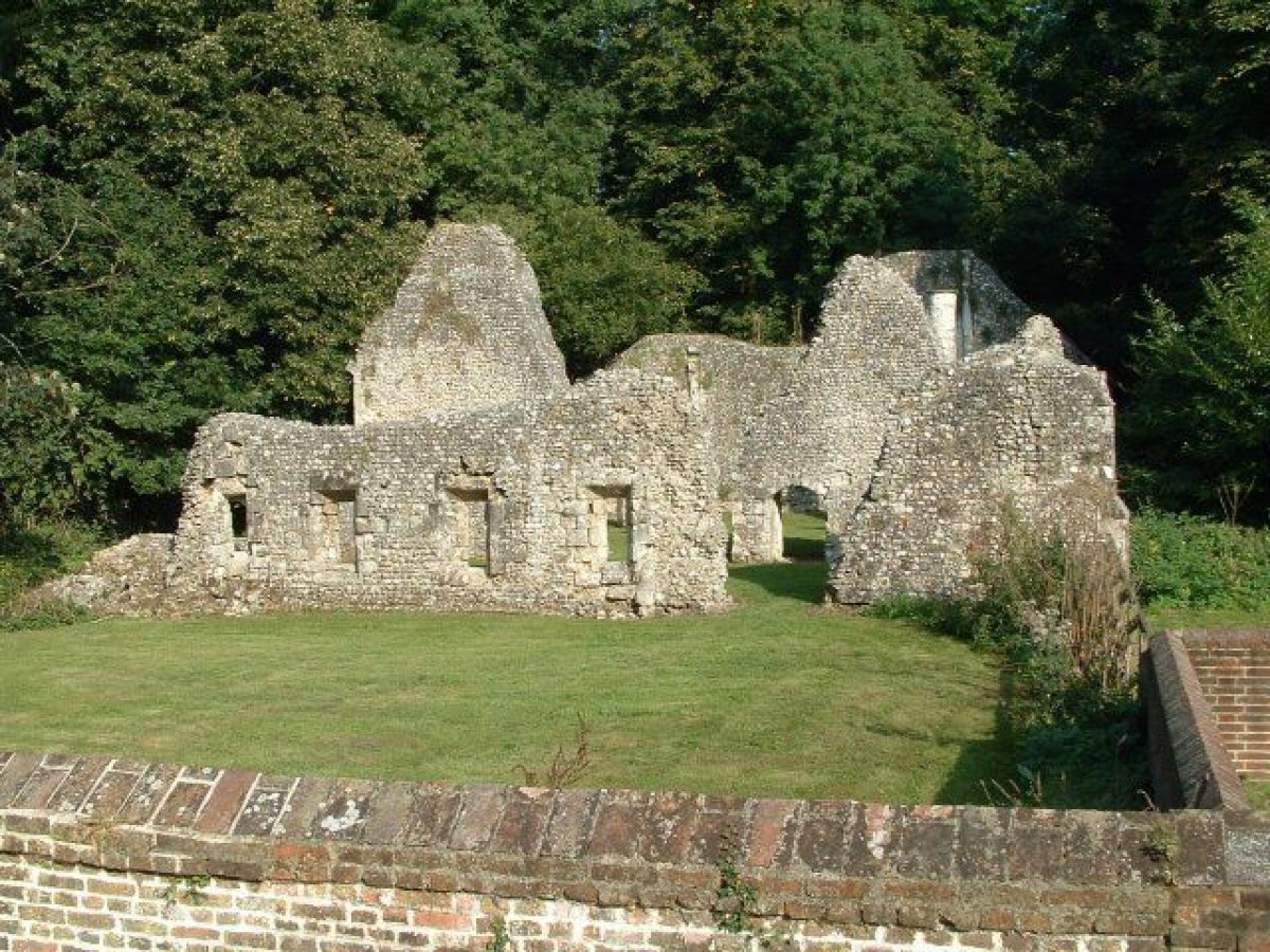
Immediately to the south of the house and stables (also demolished) lies the parish church known as the Church of Our Lady (listed grade I). Of Saxon origin, the tower dates to 1125 and the nave and chancel to c 1270. Directly to its east stand the remains of St John's House (scheduled ancient monument; listed grade I), a ruined medieval hall dating to the C12/C13. It appears to have been already in ruins by 1610 when Norden produced his map of the county.
Gardens and Pleasure Grounds
To the east of the house site and north of the parish church is the Italian garden, a sunken square compartment with a central fountain which seems to date to one of the mid C19 phases of work on the house, probably during Tunno's occupation.
South of this stands the parish church within a brick-walled enclosure, and the remains of St John's House. A photogrammetric survey of the fabric of St John's House has shown it to have been consolidated in the mid C18, in order to incorporate the ruins as a feature of the pleasure grounds (HCC Survey 1985). The encircling plantation was designed so as to reveal the ruins of St John's, and perhaps also a view of the parish church (Estate plan, 1811).
The pleasure grounds lie to the south of the church and consist of a walk laid through a broad woodland belt which encircles the brick-walled kitchen garden. Prior to the construction of the walled garden, the walk led through light woodland and formed a ring around an open rectangular paddock some 120m x 60m called 'Hovel Field' (Estate plan, 1811; Tithe map, 1839), within which stood a building. From St John's House a path leads south-eastwards to the late C18 Momento Mori bridge, a flint-faced arch with flanking walls which stands at the north-east corner of the pleasure grounds.
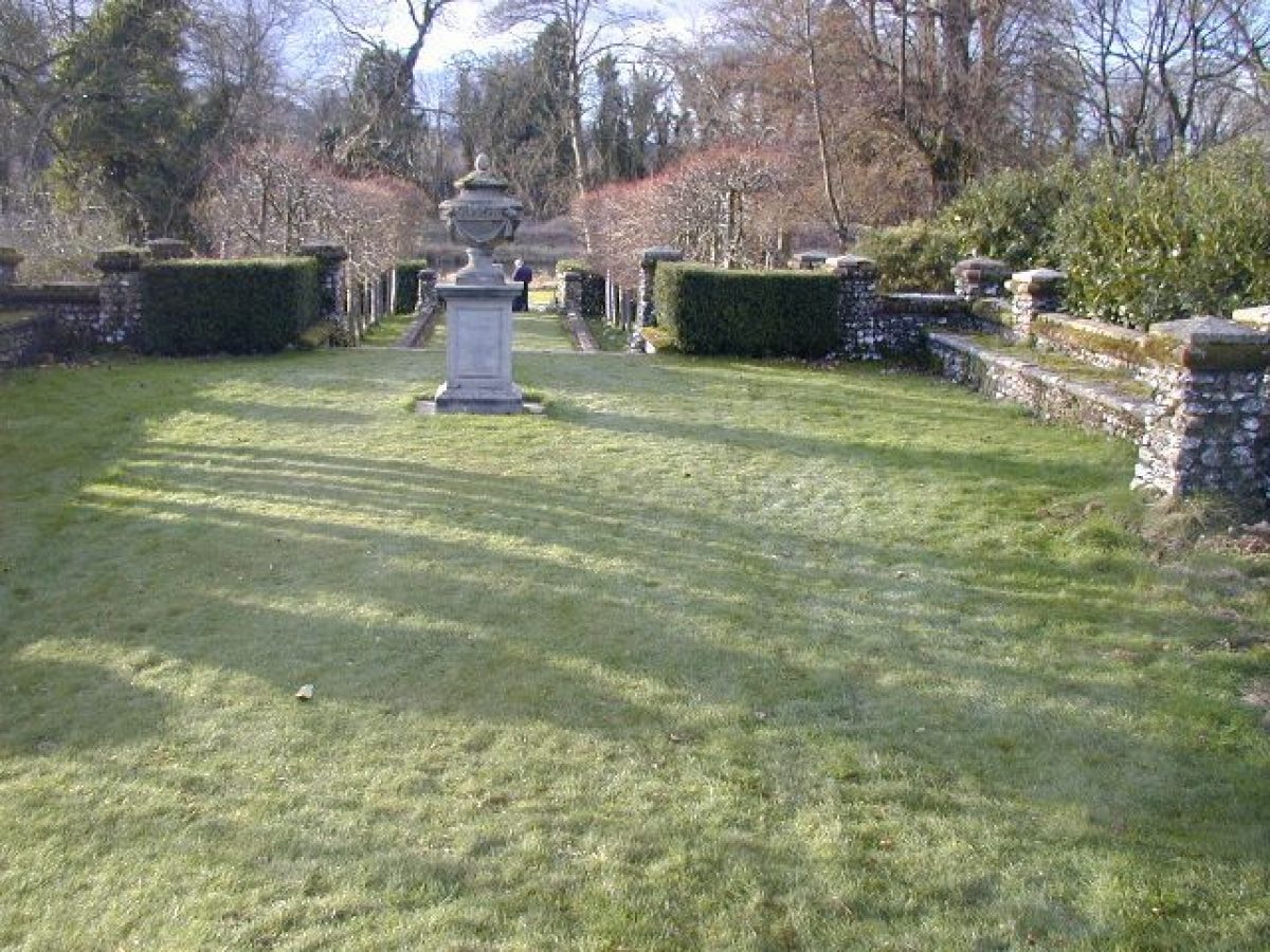
The pleasure grounds are divided from the east park by a canalised stream (now dry). A path leads under the bridge to offer views across the park from the park side of the canal. The canal leads southwards, with a formal walk alongside it on its eastern (parkward) side, and then issues into a flint-lined pool situated at its southern end. From this pool the water was then channelled underground for approximately 30m before continuing at right angles to flow westwards as a formal channelled watercourse to feed the Bath House.
The late C18 flint-built Bath House (listed grade II), also known as the Dower House or Lady Mary's Bath House, sits centrally on the south side of the pleasure grounds, astride the formal channelled watercourse (now dry). The remains of a pool for bathing were found in the basement when the building was renovated to form a dwelling (1980s). This gothic garden pavilion is built on a raised terrace, commanding views across the southern park, previously called Cowley's Meadow (Estate plan, 1811) or Great Cowleys Mead (Tithe map, 1839), which is crossed by the earthworks of a water-meadow system. The terrace extends some 200m almost due east/west. Originally supporting a raised walk laid out to the south of the Bath House, it was further ornamented and formalised in the early C19 by the addition of a retaining wall on its park side, along its full length. It is built of flintwork with taller piers at intervals along its length (listed grade II). At the west end there is a flight of steps leading down to the approach drive.
Park
The River Meon runs from north to south along the west side of the park. A dam constructed at the southern end of the river forms a long narrow lake or fishpond, with an island at its southern tip. South-west of the dam stands Paper Mill Cottage (C17 timber frame, listed grade II). The name and existence of the pond implies that the lake may have originated as a mill pond for the paper mill which is known to have been established in Warnford parish by 1618.
A walk along the east side of the lake was separated from the park to the east by a further length of canalised stream (now dry), an extension of the system surrounding the east and south sides of the pleasure grounds. To the north-west of the house site is a water wheel that formerly supplied the domestic water for the house.
The park surrounds the house site to north, east, and south. To the north is the Old Park (Tithe map, 1839), with the remains of an extensive clump crowning the summit of the hill, 1km to the north-east of the house site. The tree-lined Warnford to East Meon road divides this section of park from an area of 'Park' (within the registered area) to the south. By the early C19 this park was planted with a number of round tree clumps, several of which have been replanted (1980s). The park was also surrounded by a perimeter belt (the 'Park Belt', Tithe map, 1839).
The park is in turn separated from the enclosure to the south, named 'Colesons', by a leat (Estate map, 1811). The area was well planted with clumps and a dense scatter of park trees, and enclosed along its eastern edge by the perimeter belt, a continuation of that enclosing the park. Another leat divides Colesons from Cowley's Meadow, the southernmost section of the park, now bare of park trees but formerly planted up with several clumps and a continuation of the perimeter belt, here called Cow Leas Belt (Tithe map, 1839). The leats are part of an extensive system of water meadows, those encircling the pleasure grounds being perhaps of dual purpose, both functional and ornamental.
Kitchen Garden
The mid C19 brick-walled kitchen garden lies within the pleasure grounds. The earlier kitchen gardens presumably occupied the area set within a band of trees to the east of the C18 north drive (300m north-north-east of the house), marked on the 1811 estate plan and named 'Gardens' on the Tithe map of 1839. By 1870 (OS) this site was planted as an orchard and it is now a field.
Maps
- J Norden, Map of Hampshire, 1610 Estate plan, 1811 (private collection) [copy at Hampshire Record Office]
- Tithe map for Warnford parish, 1839 (Hampshire Record Office)
- OS 25" to 1 mile: 1st edition surveyed 1870
Description rewritten: July 2000
Register Inspector: KC
Edited: February 2004, March 2022
- Visitor Access, Directions & Contacts
Access contact details
No public access
- History
The following is from the Register of Parks and Gardens of Special Historic Interest. For the most up-to-date Register entry, please visit The National Heritage List for England (NHLE):
17th Century
Little is known of the early history of the Warnford estate. The earliest park enclosure was probably a deer park which stretched between Beacon Hill and Old Winchester Hill. In the late C16 William Neale built a house near the site of the later mansion, and in 1618 a paper mill is referred to in the will of John Knight, Neale's son-in-law, positioned along the River Meon.
18th Century
In 1754, the eleventh Earl of Clanricarde purchased the estate, having been a tenant since at least 1752. The family changed their name from Burke to the earlier form of de Burgh, as a witness of their Norman-Irish origins, called their new house Belmont, and the new park Senfoy (Saint Foin). Lancelot Brown (1716-83) notes a journey (undated) to the 'The Earl of Clanricarde' (Stroud 1975), and it appears that the Earl consulted Brown over improvements to the landscape, Brown's foreman, Spyers, being responsible for a survey. A letter exists from the Earl to Brown of 13 April 1773, asking if he, Brown, can arrange for Lord and Lady Wandesford to have a 'view of Kew Gardens' (Stroud 1975).
A description in the Morning Post of 29 September 1789 implies that the lake and pleasure grounds were completed by the time of the death of the eleventh Earl in 1782. The scheme included a 'Hermitage' described as a 'miserable bauble' (VCH 1908).
19th Century
Alterations were made to the house throughout the 19th century.
Certainly by 1839 (Tithe map) an area to the north of the Warnford to East Meon road was referred to as the 'Old Park', although the date of its establishment is unknown. The position of Warnford village, divorced from the parish church (an early foundation) which stands south of the mansion site, suggests that the village may have been removed to enable land to be imparked around the house, although no research has been undertaken to investigate this.
By 1839 the park was quite wooded and views show the mansion sitting in a Brownian-style landscape park with the River Meon forming a lake to the south.
William Abbott purchased the estate in 1826, selling it on in 1846 to Edward Tunno. By 1839 (Tithe map) the park was quite wooded and views (Prosser 1833) show the mansion sitting in a Brownian-style landscape park with the River Meon forming a lake to the south of the mansion. Tunno was responsible for major alterations to the house in 1846-7, including laying out a new approach to the mansion from Portsmouth Road which swept over a bridge across the river.
In 1865 the estate was purchased by Henry Woods, colliery owner and MP for Wigan, who carried out further alterations to the house, including a formal garden to the east of the house and considerable ornamental planting in the pleasure grounds. A great deal of planting was undertaken in the park and views were opened up so that Beacon Hill was visible from the house.
20th Century
The Woods family sold the estate in 1939, the park remaining in the ownership of the Chester family.
During the Second World War, Warnford Park was occupied by the military.
In 1958, following a long period of decline, the house was demolished. The stable block, which stood to the south of the house, has also been demolished.
21st Century
The park and pleasure grounds remain (2022) in a number of separate private ownerships. The park and pleasure grounds are in private ownership and a new house has been built adjacent to the walled kitchen garden.
- Associated People
- Features & Designations
Designations
The National Heritage List for England: Register of Parks and Gardens
- Reference: GD 2464
- Grade: II
The National Heritage List for England: Listed Building
- Reference: Lady Mary's Bath House
- Grade: II
The National Heritage List for England: Listed Building
- Reference: old mill cottage
- Grade: II
The National Heritage List for England: Listed Building
- Reference: retaining wall
- Grade: II
The National Heritage List for England: Listed Building
- Reference: St John's House (remains)
- Grade: I
The National Heritage List for England: Listed Building
- Reference: Warnford lodge, gate and gateway
- Grade: II
Scheduled Ancient Monument
- Reference: St John's House (remains)
Features
- Shelter Belt
- Terraced Walk
- Key Information
Type
Park
Purpose
Ornamental
Principal Building
Domestic / Residential
Survival
Part: standing remains
Open to the public
Yes
Civil Parish
Warnford
- References
References
- {English Heritage Register of Parks and Gardens of Special Historic Interest}, (Swindon: English Heritage, 2008) [on CD-ROM] Historic England Register of Parks and Gardens of Special Historic Interest
- Stroud, D., {Capability Brown} (London: Faber, 1975), p. 217 Capability Brown
- Page, W. {Victoria County History: Hampshire and the Isle of Wight, Volume 3} ([n.p.]: [n.pub.], 1908), pp. 268-9 Victoria County History: Hampshire and the Isle of Wight, Volume 3
- Prosser, G, F., (1833) Select Illustrations of Hampshire
- (Hampshire County Council Survey 1985) [copy on EH file] The Summer House, Warnford Park
- (Radley House Partnership 1994) The Summer House, Warnford Park
- 29 September 1789 (quoted in HCC Survey 1985) Morning Post