Introduction
The Vyne has pleasure grounds, a landscape park and a walled garden. The site covers some 100 hectares, of which the pleasure grounds are around 10 hectares. The layout dates mainly from the 18th century, with additional work from around 1840-70.
Terrain
The site lies in the shallow valley of a north-east-flowing stream, the valley sides rising gently to low crests to the north-west and south-east.The following is from the Register of Parks and Gardens of Special Historic Interest. For the most up-to-date Register entry, please visit The National Heritage List for England (NHLE):
Formal walled gardens and informal gardens with a lake, largely dating from the 18th century although with features surviving from both their 17th-century origin and their subsequent 19th- and 20th-century development, set within parkland which was established in the 16th century but planted to its present form in the 18th and 19th century.
Location, Area, Boundaries, Landform and Setting
The Vyne is situated on the east side of the A340, Basingstoke to Tadley road, c 1km north-east of the village of Sherborne St John on the lane leading to Bramley. The 100ha registered site, which comprises c 10ha of formal and informal gardens, 35ha of parkland and 55ha of woodland, lies in the shallow valley of a north-east-flowing stream, the valley sides rising gently to low crests to the north-west and south-east. The site is divided by the lane to Bramley which forms the eastern boundary to the area of the house and gardens. A further lane runs along the length of Morgaston Wood on the northern boundary while the southern edge of this wood abuts the stream and water meadows. The remaining site boundaries open onto a landscape of undulating open farmland and woodland.
Entrances and Approaches
The principal, formal approach to The Vyne is on the south-east side from the lane to Bramley. Plain wrought-iron entrance gates stand on the lane, on the axis of the south-east front. These, set between white stone piers with rustications which have sometimes been attributed to John Webb (guidebook) but may be of C18 origin (listed building description), are flanked by further iron screens ending in brick piers surmounted by stone vases (ensemble listed grade II). From the gates, a broad gravelled drive, laid out by Charles Chute in the early C20, leads c 180m north-west to the entrance porch.
The entrance front of the Tudor house probably lay on the north-west side, the alterations to the house in the C18 removing it to the south-east. In the early C19, the formal approach from the gates, marked then by an avenue, was replaced by the extension of the drive from the stables south-westwards past the front of the house and through the southern parkland to emerge on the lane near Vyne Farm (Estate map, 1829) although by the late C19 this had been realigned to emerge at South Lodge (c 450m south-east of the house). This two-storey circular brick lodge with a scalloped-tile domed roof is built in a matching style to North Lodge which stands on the north side of the kitchen garden (c 350m from the house). Both lodges (listed grade II) appear to be of C19 origin as they are first recorded on the OS edition surveyed in 1872-3. The present public entrance to the grounds of The Vyne lies some 180m to the south of the formal entrance gates.
Principal Building
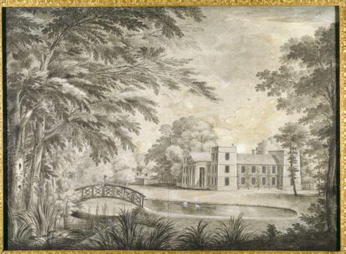
The Vyne (listed grade I) stands on level ground on the east side of the registered site. Built of red brick with a pattern of blue diapers, the two-storey building forms a south-east-facing 'U' in plan. Its central portion and the southern wing of the 'U', along with the chapel and three-storey tower at the north-east end of the north front, comprise the surviving portion of the much larger, moated Tudor house constructed by Lord Sandys between 1500 and c 1515. The north wing of the `U' was probably added in the C17 when the north front also reached its present form with the addition of the range of buildings and matching tower at the south-west corner and of the central portico, the first such on an English country house, by John Webb for Chaloner Chute in c 1654 (guidebook).
During the C18, John Chute carried out a considerable redesign of the interior and added a square tower to the centre of the south-east front which, in the mid C19, Wiggett Chute altered to its present gabled form with an added two-storey porch. Immediately north-east of the house is the red-brick Old Stable Block (listed grade I), its two wings dating variously from the C16, C17, and C19 and now in use in part as a tea room. To its north-east stands a further brick-built single-storey stable block with a loft (listed grade II), now in use as garaging and accommodation.
Gardens and Pleasure Grounds
The gardens and pleasure grounds extend from the west around to the north and north-east of the house. The north-west front opens onto a grassed terrace with a gravelled walk, created by Wiggett Chute in the mid C19, which runs the length of the house. From the terrace, open lawns slope gently north-westwards down to the shore of the lake which forms a long ribbon bordering the pleasure grounds from a point c 180m south-west of the house to its dam c 220m to the north-east. There are vistas from across the lake to the north-west front. The `Long Garden Pond' and a `Great Pond', referred to in the Chute accounts of 1743 (HRO), were probably the forerunners of the lake which was enlarged to its present size and shape by 1776 (Moss survey).
North-east beyond the house, the terraced walk, flanked to the north-west by lawns dotted with clumps and individual trees including cedar and pine, continues for c 50m to the Flower Garden. This rectangular garden, largely enclosed by yew hedges (that to the north-west planted in the late 1990s), was designed and planted in 1997-8 as an Edwardian flower garden with island beds of annuals cut into the lawn in the form of a Greek cross which reflects the floor plan of the Garden Pavilion (listed grade I) which stands in the north-east corner. This circular two-storey building of red brick with a domed roof and four two-storey projections, each with an arched doorway and an arched pedimented window above, dates from the C17 and was possibly built for Chaloner Chute by John Webb. It formed the eastern one of a pair, shown in a painting of 1756 by J H Muntz (guidebook), which were features in a larger, formal garden that was removed, with the western pavilion, in the mid to late C18 by John Chute (ibid).
The present open flower garden was formed by Wiggett Chute in the mid C19, on the site of the walled `little kitchen garden' recorded on the estate map of 1829. From the north-west corner of the Flower Garden, a gravelled path leads 100m due north, along a lime avenue planted in the 1880s by a later Chaloner Chute, to the south wall of the kitchen garden. It then turns north-west to cross the dam and runs south-west to follow the north-west shore of the lake which is planted intermittently with tree clumps. Towards the south-west end (c 150m from the house), brick and stone foundations on the south-east shore survive as remnants of a mid C19 iron bridge (listed, when standing, grade II) which was destroyed in a storm in 1986 (ibid). East of the bridge site and leading back towards the house, the south-east side of the lake is laid out as a Wild Garden, established by Sir Charles Chute c 1910 with semi-natural plantings of trees and shrubs and, since 1995, with added informal drifts of perennials. Grass paths lead from the Wild Garden to the herbaceous borders on the south-west side of the house. These, enclosed within a rectangle of yew hedges, were laid out by the National Trust in the 1960s and replanted in 1996.
Park
The park lies to the south and north-west of the house and on the east side of the lane to Bramley. It is well furnished with a scatter of mature individual trees and tree clumps with, to the north-west, a few exotics mixed with the otherwise deciduous cover. The present pattern represents, although with some subsequent reduction including that caused by storm damage in 1987 and 1990, that shown established on the OS 1st edition map of 1872-3. An enclosed deer park, centred on an area around the present Vyne Farm (c 180m south-east of the house), existed in the medieval period, into which, in the C16, land to the west of the lane to Bramley, including that around the house itself, was incorporated. During the C17, most of the medieval deer park was turned over to farmland, leaving just the land west of the house as parkland, although later the present area east of the lane to Bramley was re-imparked.
Kitchen Garden
The kitchen garden lies c 220m north-east of the house, close to the site boundary. Its roughly rectangular, c 90m x 45m form is enclosed by high red-brick walls (listed grade II) and is laid out to grass with a central north to south gravelled walk. The garden is shown on William Moss' map of 1776, although it may be of earlier origin (guidebook).
Other Land
West of the house and the western parkland lies Morgaston Wood, an extensive area of woodland planted in various compartments of hardwoods, conifers, and coppice. The Wood is cut by a series of interconnecting walks and rides, these possibly surviving from those said by Chaloner Chute to have been cut in the C18 by John Chute (ibid). The north side of the wood is bounded by Morgaston Road, created in the mid C19 by Wiggett Chute to delineate the boundary of The Vyne estate. Dating from the same period is a pair of lodges (600m north-west of the house) framing an entrance to the estate and comprising Beech Lodge (on the west side) and The Beeches (on the east side), both two-storey brick estate cottages built in the Tudor style (both listed grade II).
Maps
- William Moss, A Correct Survey of The Vine belonging to Thomas Chute, 1776 (Hampshire Record Office)
- Estate map, 1829 (Hampshire Record Office)
- Tithe map for Sherborne St John parish, 1840 (Hampshire Record Office)
- OS 6" to 1 mile: 1st edition surveyed 1872-3; 2nd edition published 1897; 3rd edition published 1912
- OS 25" to 1 mile: 1st edition surveyed 1872; 2nd edition published 1896; 3rd edition revised 1909, published 1911
Illustrations
- J H Muntz, painting of The Vyne, 1756 (reproduced in guidebook 1998)
Description written: August 1998
Amended: November 2000
Edited: February 2004, March 2022
- Visitor Access, Directions & Contacts
Telephone
0844 800 1895Website
http://www.nationaltrust.org.ukAccess contact details
The site is open between February and October. For more details visitor information visit the National Trust website.
Directions
The site is 4 miles north of Basingstoke off the A339.
Owners
The National Trust
Heelis, Kemble Drive, Swindon, SN2 2NA
- History
The following is from the Register of Parks and Gardens of Special Historic Interest. For the most up-to-date Register entry, please visit The National Heritage List for England (NHLE):
14th Century
The Vyne formed part of the manor of Sherborne Cowdray which belonged to the Fyffhide family and which, on the death of William Fyffhide in 1362, was recorded as having a manor house and chapel (Victoria County History 1908). It came into the hands of the Sandys family in 1386 who also acquired a medieval deer park which lay to the north-east of the present parkland.
15th - 16th Century
After a short period of ownership through marriage by the Brocas family, the Sandys regained possession in 1488 and in 1496 it was inherited by William Sandys who was ennobled as Baron Sandys in 1523 and appointed as Henry VIII’s Lord Chamberlain. He integrated the former medieval buildings on the site to form a substantial moated courtyard mansion which was probably completed by 1515; this mansion probably had gardens (guidebook). Much of the present parkland was also incorporated into the estate during the 16th century. The Vyne descended through the Sandys family although after the death of Lord Sandys in 1540, they seem to have preferred the former priory at Mottisfont (see the description of this site elsewhere in the Register), which Lord Sandys had acquired in 1536, as a home.
17th Century
Some years after the death of Colonel Henry Sandys in 1644, his son sold The Vyne to Chaloner Chute, a Parliamentarian and later Speaker of the House of Commons during the Commonwealth. He demolished two thirds of the Tudor house and made significant alterations to the remainder including the addition of the north-east portico, employing the architect and pupil of Inigo Jones, John Webb (1611-72). He added further to the gardens north-east of the house and he, or his successors, also built ponds and a walled garden (Chute archives).
18th - 19th Century
The Vyne was inherited in 1754 by John Chute who, as a friend of Horace Walpole, assisted with the decoration of Walpole’s Gothic Revival villa at Strawberry Hill (see the description of this site elsewhere in the Register) in London. Chute redesigned and refurnished much of the interior of the house, removed most of the formal gardens, and may have been responsible for the enlargement of the lake to its present form. After his death in 1776, little change occurred at The Vyne until it was inherited by a Chute cousin, William Lyde Wiggett, in 1827, Wiggett taking the name Chute.
20th - 21st Century
William improved and modernized the whole estate, repairing and altering both the interior and exterior of the house and the stables and gardens. He was succeeded by Chaloner Chute, then by his grandson Charles who was created a baronet in 1952. On the death of Carles Chaloner in 1956,
The Vyne was bequeathed to the National Trust and it remains (2022) in their care.
Period
18th Century (1701 to 1800)
- Associated People
- Features & Designations
Designations
The National Heritage List for England: Register of Parks and Gardens
- Reference: GD1867
- Grade: II
Features
- House (featured building)
- Earliest Date:
- Latest Date:
- Herbaceous Border
- Orchard
- Structure
- Description: Walled garden.
- Earliest Date:
- Latest Date:
- Glasshouse
- Description: Currently being restored.
- Summerhouse
- Description: The feature is described as 'possibly the earliest domed garden building in England' (National Trust).
- Earliest Date:
- Latest Date:
- Specimen Tree
- Description: Oak tree claimed to be over 600 years old.
- Lake
- Key Information
Type
Estate
Purpose
Ornamental
Principal Building
Domestic / Residential
Period
18th Century (1701 to 1800)
Survival
Extant
Hectares
100
Open to the public
Yes
Electoral Ward
Sherborne St John
- References
References
- {English Heritage Register of Parks and Gardens of Special Historic Interest}, (Swindon: English Heritage, 2008) [on CD-ROM] Historic England Register of Parks and Gardens of Special Historic Interest
- Pevsner, N. and D. Lloyd, {The Buildings of England: Hampshire and the Isle of Wight} (Harmondsworth: Penguin, 1967), pp. 634-5 The Buildings of England: Hampshire and the Isle of Wight
- Page, W. {Victoria County History: Hampshire and the Isle of Wight, Volume 4 } (London: Constable, 1911), pp. 160-5 Victoria County History: Hampshire and the Isle of Wight, Volume 4
- Chilton-Jones, Marcus {The Vyne Garden Conservation Plan} (2002) The Vyne Garden Conservation Plan
- Chilton-Jones, Marcus (for the National Trust) {The Vyne Garden Conservation Plan} (2002) The Vyne Garden Conservation Plan
- Chilton-Jones, Marcus (for the National Trust) {The Vyne Garden Conservation Plan} (2002) The Vyne Garden Conservation Plan
- Chilton-Jones, Marcus (for the National Trust) {The Vyne Garden Conservation Plan} (2002) The Vyne Garden Conservation Plan
- Rutherford, Sarah {The Vyne: Historic landscape appraisal} (2014) The Vyne: Historic landscape appraisal
- Fretwell, Katie {The Vyne: Park and Garden Survey} (1987) The Vyne: Park and Garden Survey
- Paterson, A., (1978), pp 149-50 The Gardens of Britain 2: Dorset, Hampshire and the Isle of Wight
- National Trust Enterprises Ltd (1998) The Vyne, guidebook,
- (20 June 1903), pp 838-47; 49 (14 May 1921), pp 582-9; (21 May 1921), pp 612-19; 121 (3 January 1957), pp 16-19 Country Life, 13