Introduction
Valentines Park is a late-19th-century public park, extended and developed in the early-20th century. The park occupies about 50 hectares. In addition to the municipal facilities provided, a number of features from the 18th-century layout remain, including the rectilinear canal with rockwork grotto and a grotto shelter, dovecote, sundial, walled garden and ha-ha. In the south-west of the park is the main lake with ornamental woodland, fed by the canalised Cranbrook. The mansion, gardens and park were restored in 2009 with Heritage Lottery funding.
Terrain
The ground at Valentines Park slopes gradually from north to south.www.historicengland.org.uk/listing/the-list
Late 19th century public park, formed from 18th to 19th century gardens and farmland, further developed and extended in early 20th century.
DESCRIPTIONLOCATION, AREA, BOUNDARIES, LANDFORM, SETTING
Valentines Park, c 50ha, is located to the north of Ilford and south of Gant's Hill, in the London Borough of Redbridge. Valentines Park is bounded by Cranbrook Road to the north and south-west, Emerson and Holcombe Roads to the west, Valentines, Melbourne and Auckland Roads to the south, Brisbane and Quebec Roads to the south-east, and Perth Road to the east. There is a school bounding the park in the north-east corner. The ground at Valentines Park slopes gradually from north to south. There are views from the higher ground, around the House, southwards over the park. The boundaries of the park are marked by wrought- and cast-iron fences of various designs.
ENTRANCES AND APPROACHES
There are fifteen entrances to Valentines Park, four of which are vehicular. The main approach to Valentines House is from Emerson Road in the north-west corner of the park. A drive from the late C19 entrance gates curves east to a circular entrance forecourt before the north front of the House. There are further vehicular entrances from Melbourne Road (in the centre of the south side), from Cranbrook Road (on the south-west side), and from Perth Road (on the east side). A pedestrian entrance from Emerson Road leads through a pair of early C18 stone gate piers, supporting urns with acorn finials, some 150m south of the House. (Moved to here from their original location at the main entrance to the House in c 1912, listed grade II.) The main pedestrian entrance is now in the south-west corner of the park, from Cranbrook Road.
PRINCIPAL BUILDING
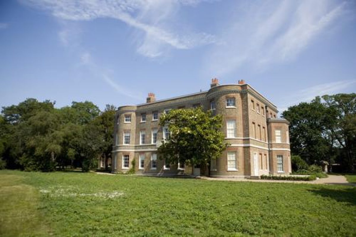
Valentines House (listed grade II*) was built in the 1690s by James Chadwick. The exterior was extensively altered in the mid C18, and the House was further altered and enlarged in 1811, to its present appearance.
GARDENS AND PLEASURE GROUNDS
To the south and east of the House are lawns with scattered mature trees, large yuccas, and formal beds of shrubs or bedding plants. On the south front of the House there is a large magnolia and a shrubbery extends from the west side of the House up to the main entrance and then to a lodge in the north-west corner. The southern boundary of the lawns and kitchen gardens is formed by an C18 brick ha-ha (listed grade II), which runs for 150m from Emerson Road, north-east to the Long Canal. It has small, semicircular bastions along its length and divides the gardens to the south of the House from the park. From the ha-ha there are good views over the ground to the south-east (formerly the C19 park belonging to Valentines and now known as The Glade), which consists of open lawns with scattered mature trees. The north-east side of the lawn borders the kitchen garden, with an aviary attached to the west wall of the lower part of the kitchen garden. To the south of the lower kitchen garden is a rosery, the north boundary of which is the kitchen garden wall. The rosery was laid out in the 1870s and consists of a formal arrangement of rose beds with rose arches for climbing roses. The roses are mostly replacements planted in the 1920s and 1940s/50s. To the north of the lawns and the kitchen gardens are tennis courts along the north boundary. These are on the site of a complex of C18 and C19 outbuildings, farm buildings and further walled areas, which were demolished c 1912 and replaced by the tennis courts. A vinery, which contained the Black Hamburgh vine, was retained in the new public park but was later demolished. A cutting from the Hampton Court vine was planted at Valentines in the 1990s.
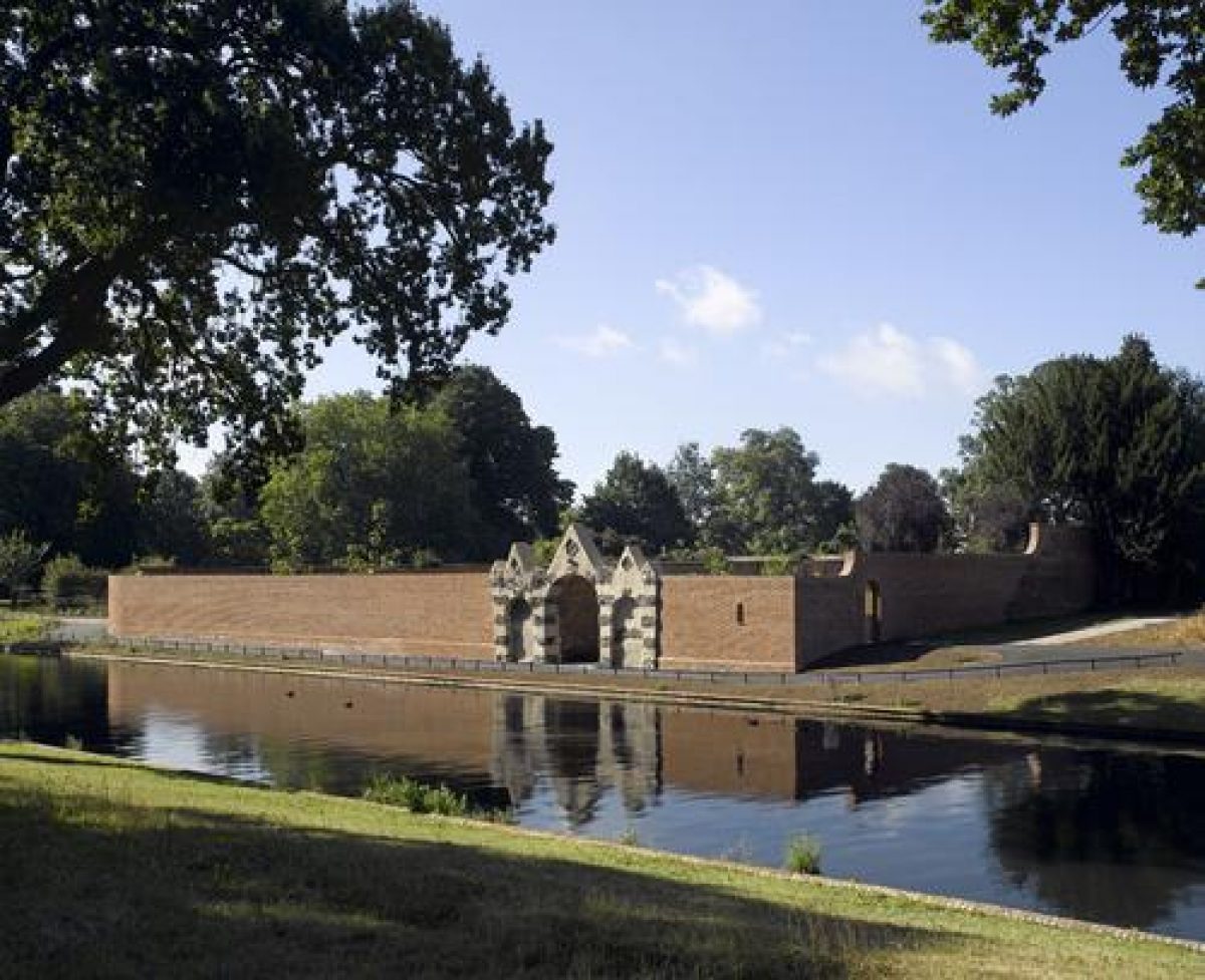
A path leads between the tennis courts and the kitchen gardens to the early C18 Long Canal (or Long Water), 150m north-east of the House. The Canal is 200m long and 15m wide, with brick revetments. Immediately to the south is an early C18 Grotto Shelter (listed grade II), with a brick core, decorated in Portland stone with rusticated, flintwork quoins. It has three bays, with a large central opening containing seats, the ceiling of which is decorated with shells and copper slag decorations and blind flanking arches. The structure is partly overgrown with ivy (1998). At the northern end of the Long Canal is another early C18 grotto, known as the Canal Head Grotto (listed grade II), with a brick core, stone and flint rustication, and the remains of some shellwork. A central arch is flanked by two lower arches and was formerly a cascade. To the north of the Long Canal is a small rectangular canal, known as the Horse Pond, which has a stone wall revetment. A path leads along the west side of the Long Canal, the northern c 100m alongside the kitchen garden and the southern 100m alongside The Glade. The northern section was known in the C19 as the Terrace Walk and was lined by a castellated wall along the Canal edge (removed C20). The southern section, which is through trees, was lined with arches of climbing plants, known in the C19 as the Green Bower (removed C20).
At the northern end of the Terrace Walk a path leads between the Horse Pond and Long Canal and into the American Gardens, which lie between the Long Canal and the eastern boundary of the park. This area was an C18 Wilderness and part of the present layout is derived from this phase. The area was developed in the C19 as American Gardens and much of the planting survives. The shrubberies contain evergreen and flowering shrubs, including holly and thorn, with clumps of azaleas, rhododendrons and acers. There are fine, scattered and grouped mature trees throughout the American Gardens and in the gardens of Valentines House including tulip trees, clumps of Scots pine, sweet and horse chestnuts, holm oak, oak and limes, and fine cedars of Lebanon. The paths within the American Gardens are formally arranged with a straight, raised walk along the eastern edge and a patte d'oie radiating from its centre, the three arms (now grown over) all leading to the Long Canal. The axis of the central arm is on the same alignment as the garden ha-ha and southern edge of the Rosary and it crosses the Long Canal at its centre. The straight east walk was known as the Bishop's Walk and there is a mound at the northern end and some remaining yew trees along the length of the Walk. The southern mound and most of the yews which lined the Walk have now gone.
The American Gardens continue past the southern end of the Long Canal and run alongside a further piece of water, which is known as the Fish Pond. This is irregular in outline and has an C18 grotto at the northern end (the Southern Grotto, with two bays faced with rockwork and built into a mound; in 1998 very overgrown). There is a tree-covered island in the north-west corner of the Fish Pond and a narrow stretch of water, known as the Wishing Well Pond, leads north from the north-east corner of the Fish Pond. Near the Wishing Well Pond is Jacob's Well, a domed brick structure, the exterior of which is covered in concrete and flints. The southern half of the American Gardens has an informal arrangement of serpentine paths. At the southern end the paths converge on a clearing in which there is a massive cedar of Lebanon. To the south of the cedar is a ha-ha, forming the southern limit of the C18 and C19 pleasure grounds.
From the ha-ha there are views over a large stretch of land (c 15ha) which crosses the middle of the present park and divides the C18 and C19 pleasure grounds to the north from the late C19 municipal park to the south. This ground consists of open grassland with sparsely scattered trees in the centre and areas for sports to the west and east. At the western end of this central part of the park is a rectangular plot of ground dedicated to sports, including from west to east: a private cricket club and the county cricket ground to the west (with a pavilion in the north-east corner), three bowling greens, tennis courts, and a children's playground (laid out in the 1990s) to the east. Open ground extends to the east, past the site of an open-air swimming pool (demolished in 1995), to the eastern boundary of the park, where there are further tennis courts. The park then extends northwards, up the east side of the American Gardens, as a Pitch and Putt course.
To the south of this ground lies the original 19ha which was laid out as Cranbrook Park in 1898-9. At the eastern end of this part of the park is a boating lake, which is an elongated octagon in shape. To the west the Cran Brook stream is canalised between stepped concrete revetments, and flows westwards through wooded ground. To the south is Melbourne Field, open ground on the south side of the park. The Cran Brook feeds the principal lake which is orientated west/east across the centre of the western half of the municipal park. The lake, known as the Boating Lake, has a clay edge along the south side and a concrete edge to the north. There is a small island at the eastern end of the lake. To the south-east of the lake, a linear path (leading to the entrance on Melbourne Road) is lined by an avenue of trees and has a large C19 drinking fountain half-way along it. To the west of the drinking fountain there is a bowling green and pavilion and paths meander west from here through lawns with scattered trees to a series of garden areas, including a sunken heather garden, nursery areas, a C19 rose garden and a late C20 Sensory Garden in the south-west corner. The paths then lead north around the west edge of the lake, with a Clock Tower (presented by W P Griggs Esq of Cranbrook Park in 1899) overlooking the lake to the west. To the west of the Clock Tower is a garden area known as The Wash, with the Cran Brook flowing through banks planted with willows, maples and other trees. An ornamental fountain is situated in the centre of the stream, which used to be crossed by rustic bridges but now has a single late C20 functional bridge.
On the north-west edge of the lake is a late C19 boathouse. From here three paths run west/east, parallel to each other. The southern path runs along or near to the lake edge, the northern path along the southern edge of the cricket pitch, bowling greens and tennis courts. At the central point of the central path is a circular enclosure of hedges, with rose beds, surrounding the base and balustrading of a late C19 bandstand (the bandstand itself no longer extant). At the eastern end of the central path is a 1960s' refreshment pavilion, which replaced the one from the 1900s on the same site.
KITCHEN GARDEN
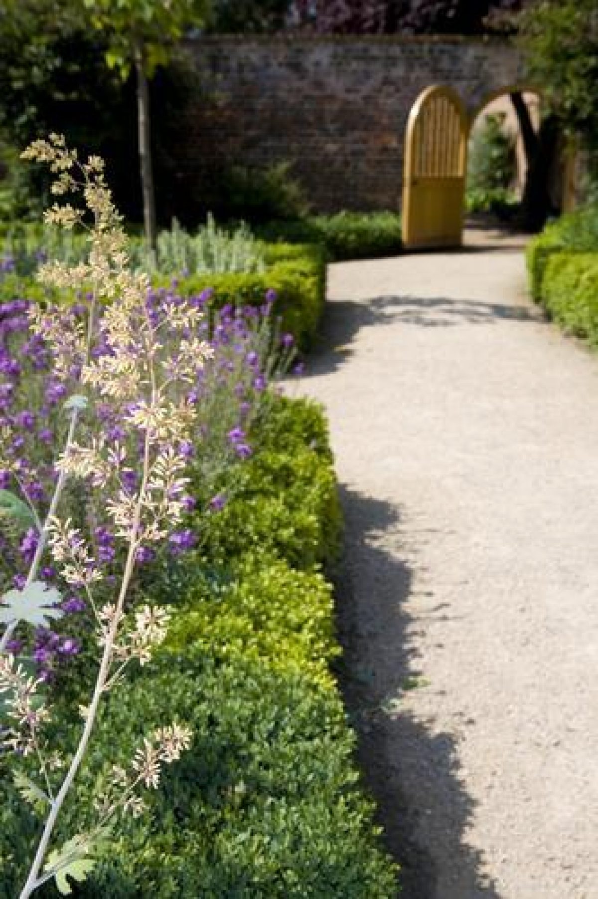
The kitchen garden is located 60m to the north-east of the House. In the north-west corner of the kitchen garden is an early to mid C18, two-storey, octagonal dovecote (listed grade II with the garden walls) in plum brick with red-brick dressings. The dovecote has ogee windows at first-floor height and a slate roof. The kitchen garden is bordered by the dovecote and outbuildings on the west side and by 3m high brick walls to the north and south. The kitchen garden was originally open on the east side, giving views over the Long Water but is now (1998) fenced due to the instability of the walls. The kitchen garden is in two parts: the larger, northern part which was used as a nursery in the C20 and is now derelict; and the smaller, southern part which since the 1870s has been laid out as a formal garden, known as the Parterre Garden. The Parterre Garden is laid out with a formal arrangement of beds bordered by box hedges, with gravel and stone paths. The hedges enclose beds with large yuccas and bedding. In the centre are arches for climbing roses. There are arched entrances in the corners of the west side. The east side is open to the Long Water and towards the east end of the central path is an early C18 Portland stone base for a sundial (listed grade II, the sundial itself now missing). There is a gardener's cottage on the north side of the kitchen garden, with a small walled enclosure to the north, of which the west wall has heating ducts for fruit growing.
REFERENCES
P Muilman, History of Essex IV, (1770), p 276
D Lysons, Environs of London IV, (1796), p 87
Gardeners' Chronicle ii, (1873), p 1307
Gardeners' Chronicle ii, (1878), pp 272-273, 277
The Future of Valentines Park, Ilford, Essex, (Valentines Park Extension Council 1912)
N Pevsner, The Buildings of England: Essex (2nd edn 1965), p 224
The Victoria History of the County of Essex V, (1966), pp 211-212
I Dowling, Valentines Park, Ilford: A Century of History (1999)
Maps
Proposed Extension of Valentines Park, 1912 (in The Future of Valentines Park, Ilford, Essex)
OS 25" to 1 mile: 1st edition surveyed 1863
2nd edition published 1897
3rd edition published 1913
Description written: December 1998
Amended: March 2000
Edited: May 2000
- Visitor Access, Directions & Contacts
Access contact details
This is a municipal park, open daily for general public use.
Directions
Rail: Ilford. Tube: Gants Hill (Central). Bus: 128, 150, 167, 296, 396.
Owners
London Borough of Redbridge
Town Hall, 128-142 High Road, Ilford, Essex, IG1 1DDOther Websites
- http://www.valentinesmansion.com/
- http://www2.redbridge.gov.uk/cms/leisure_and_libraries/leisure/parks_and_open_spaces/list_of_parks_and_open_spaces-/valentines_park.aspx
- https://www.historicengland.org.uk/listing/the-list/list-entry/1000843
- http://www.londongardensonline.org.uk/gardens-online-record.asp?ID=RED037
- History
The following is from the Register of Parks and Gardens of Special Historic Interest. For the most up-to-date Register entry, please visit the The National Heritage List for England (NHLE):
www.historicengland.org.uk/listing/the-list
HISTORIC DEVELOPMENT
The estate of Valentines was by the early 18th century one of the largest in the parish of Ilford. It was made up of two tenements, which had been separated in the mid 17th century and were then reunited in the early 18th century: a copyhold tenement of 8 acres (about 3.3 hectares) known as Valentines (on which Valentines House was built) and a freehold tenement of 120 acres (50 hectares) known as Valentines Farm (and later known as Middlefield Farm). The tenements were held together until the death of Francis Fuller, Lord Loxford, in 1636, when they were separated, the larger tenement being owned by the Loxford family until the early 18th century, when it was purchased by Robert Surman. Valentines (the smaller tenement) passed from Henry Ayscough to Edward Beadle, and then to Robert Bertie in 1666. The tenement was then surrendered to Sir Thomas Skipwith in 1688, who surrendered it to Elizabeth Tillotson in 1696. Elizabeth Tillotson (d 1702), was the widow of John Tillotson, Archbishop of Canterbury (d 1694) and a niece of Oliver Cromwell. It was her son-in-law, James Chadwick (d 1697), who is said to have built Valentines House in the final years of the 17th century (Victoria County History 1966, 211). In the late 17th century, the ancient royal forest of Hainault extended to Ilford and the house was described as being 'in the forest' (Birch 1752). Elizabeth Tillotson died in 1702 and the property was granted to George Finch, whose son William inherited on his father's death in 1714. In 1724, Finch surrendered the property to Robert Surman, who acquired the freehold interest in the property and reunited it with Valentines Farm.
Surman owned the property between 1724 and 1754 and improved the House and gardens. Most of the formal features within the northern part of the park date from this period. In 1754 the estate was purchased by Sir Charles Raymond, who extended the property by adding the neighbouring estates of Highlands and Wyfields. Raymond planted a Black Hamburgh vine at Valentines in 1758, of which William Gilpin (1724-1804) gave an account in Remarks on Forest Scenery (1791). A cutting of this vine was planted at Hampton Court in about 1769, and became the famous Hampton Court Vine. After Raymond's death in 1788, the Highlands estate was sold separately and the Valentines estate, with most of the Wyfields lands, was sold to Donald Cameron, who already owned the Ilford Lodge estate to the south of Valentines. The estate then comprised 400 acres (about 166 hectares) of land. On the death of Cameron in 1797 the estate was again divided: the House with 174 acres (72.5 hectares) was sold to Robert Wilkes, and then, in 1808, to Charles Welstead. Welstead died in 1832 and his executors sold the estate to Charles T Holcombe (d 1870) in 1838. Holcombe was succeeded by his niece Sarah, wife of Dr Clement M Ingleby.
In 1898 Mrs Ingleby sold 47 acres (19 hectares) of the Valentines estate to Ilford Borough Council, to be laid out as a public park. The land included a large lake and was opened as Cranbrook Park in 1899. Sarah Ingleby died in 1906, and her son, Holcombe Ingleby, gave 10 acres (4 hectares) of land (the American Gardens) to the Council. In 1907 the Council purchased a further 37 acres (15 hectares) of Valentines and both the new areas were opened to the public in March 1907 as Valentines Park.
The threat of demolition of the House and development of the remaining land was avoided in 1909 when the 'Valentines Park Extension Committee' was established in order to raise funds and save the gardens. The land to the south of the House (Emerson Road, The Square, Bethel Avenue, Tillotson Road and Holcombe Road) was developed as The Ilford Garden Suburb, which raised sufficient assets to purchase the remaining land. The House and the 22 acres (9 hectares) of land surrounding it were purchased in 1912 and the extension to Valentines Park was opened to the public in 1913. The adjacent Middlefield Farm estate was sold in 1924 and at this stage a further 8.8 acres (3.5 hectares) were added to the park, which then totalled 125 acres (50.5 hectares).
Valentines Park is owned and managed as a public park by the London Borough of Redbridge. The House was used as the headquarters of the Borough's Housing Department but has been unoccupied since 1993. A charitable trust was set up in 1999 to maintain the House.
- Features & Designations
Designations
The National Heritage List for England: Register of Parks and Gardens
- Reference: GD1839
- Grade: II
Features
- Boundary Fence
- Description: The boundaries of the park are marked by wrought- and cast-iron fences of various designs.
- Aviary
- Bandstand
- Bowling Green
- Lake
- Mansion House (featured building)
- Description: The house has recently been restored, and is now a venue for exhibitions and activities.
- Earliest Date:
- Latest Date:
- Kitchen Garden
- Rose Garden
- Canal
- Description: Long Water canal.
- Grotto
- Dovecote
- Garden Building
- Description: The gardener's cottage is now in use as a cafe.
- Wall
- Description: The walled garden.
- Key Information
Type
Park
Purpose
Recreational/sport
Principal Building
Parks, Gardens And Urban Spaces
Survival
Extant
Hectares
50.62
Open to the public
Yes
- References
References
- {English Heritage Register of Parks and Gardens of Special Historic Interest} (Swindon: English Heritage 2008) [on CD-ROM] Historic England Register of Parks and Gardens of Special Historic Interest
- Pevsner, N and Radcliffe, E {The Buildings of England: Essex} (Harmondsworth: Penguin, 1965) p 224 The Buildings of England: Essex
- Powell, W.R. {Victoria County History: Essex, Volume 5} (Oxford University Press, 1966) 211-12 Victoria County History: Essex, Volume 5
- {Valentines Park Restoration Plan} (1997) Valentines Park Restoration Plan
- Land Use Consultants {Valentines Park Restoration Management Plan} (1999) Valentines Park Restoration Management Plan
- Land Use Consultants {Valentines Park: Management and Maintenance Plan} (2003) Valentines Park: Management and Maintenance Plan
- Land Use Consultants {Valentines Park Restoration Management and Maintenance Plan} (2004) Valentines Park Restoration Management and Maintenance Plan
- {Valentines Park: 10 year Management and Maintenance Plan - 2009 to 2018} (2009) Valentines Park: 10 year Management and Maintenance Plan - 2009 to 2018
Contributors
London Parks and Gardens Trust