Introduction
Swinton Castle has an associated landscape park and pleasure grounds. The pleasure grounds are made up of informal gardens with lawns and shrubbery. The park is separated from the gardens by Home Lake. This is a serpentine stretch of water designed to look like a river. Features of interest include a 'Coffin Pond' with stone coffins of possible Saxon date laid out around the boathouse, as well as woodland, a rockery, icehouse, sunken path and a recently restored walled garden.
The site is now a hotel and open by appointment only.
Terrain
The site is on land which rises gently to the west.Mr William, The Second DanbyThe following is from the Register of Parks and Gardens of Special Historic Interest. For the most up-to-date Register entry, please visit The National Heritage List for England (NHLE):
Gardens and extensive pleasure grounds with grottoes, rustic bridges and rockwork laid out from 1796 to about 1820 under the direction of Adam Mickle the second and others for Sir William Danby, incorporating lakes and landscaping of around 1760. The park probably has 17th-century or earlier origins.
Location, Area, Boundaries, Landform and Setting
Swinton Castle lies c 1 km south-west of Masham in a rural and agricultural setting. The c 105 ha site is on land which rises gently to the west. The site is walled and it is bounded by minor roads.
Entrances and Approaches
The principal entrance to the site is on the east side where there is a gateway and lodges (listed grade II) of c 1754 with a central arched carriageway entrance leading to a drive which follows a curving route to the south and then to the north before arriving at a porte-cochère on the east side of the Castle. There are a number of secondary entrances around the site via doors set into the park wall which lead to a system of drives and tracks running through the site.
Principal Building
Swinton Castle (listed grade II*) probably originated in 1695 when Sir Abstrupus Danby built a new house, possibly to his own design or as a collaboration with his mason William Sympson. In 1764-7 the house was remodelled for William Danby by John Carr and further works were undertaken by John Foss of Richmond in 1791 for his son, also William. The building was transformed in the early 1820s by Robert Lugar who embellished it with turrets and castellations and introduced a huge round tower and a porte-cochère. Further alterations were made in the late C19 by Lord Masham. The Castle is in use as a conference and training centre (1998).
A stable block (listed grade II) lies c 20 m north of the Castle. It was built c 1752 probably as a collaboration between William Danby and Matthew Ward. Various ancillary buildings are ranged around a courtyard on the west side of the stables.
Gardens and Pleasure Grounds
Lawns front the south and east sides of the Castle, and there are views to the south and south-west over a lake and rising parkland beyond. A garden was laid out in this area to a design by George London (d 1714) of 1699. A C17 view (reproduced in CL 1966) shows a walled forecourt to the east of Sir Abstrupus Danby's house with a grid of paths and lawns or beds embellished with clipped trees, urns and statuary. Fountains were introduced in 1706 under the supervision of an engineer called Howgill, but it is not known exactly where they were situated. A painting of c 1815 (ibid) shows an informal garden with lawns and a shrubbery on the east side of the house and it is probable that formal gardens were swept away by William Danby in the 1760s as part of the landscaping being undertaken at that time.
On the west side of the Castle there is a substantial rockery immediately west of the building through which a sunken path with rockwork steps leads. An icehouse is concealed beneath part of the rockery. Paths lead through lawns on ground which rises to the north-west, and c 70 m west of the Castle the remains of a gothick orangery lie on an eminence with views to the south over the park and Home Lake. A path, divided from the park by a ha-ha, leads west as an avenue of yews in the south-west side of the garden, and it continues as an avenue of alternating lime and yew into extensive wooded pleasure grounds with planting which includes large numbers of yew trees. A path leads off to the north to an enclosed garden, called Spring Garden, within woodland c 200 m west of the Castle. The Garden is rectangular and lies immediately to the west of the kitchen garden, which is entered from a gateway with stone gate piers on the east side of the Garden. A path runs north/south across the Garden as an avenue of flowering cherry trees and the remainder of the layout is informal with beds, scattered shrubs and specimen trees. The Garden seems to have developed from a rectangular enclosure shown on the 1856 OS map, which is shown lined with trees on that of 1892. The 1956 OS map shows it in approximately its present form.
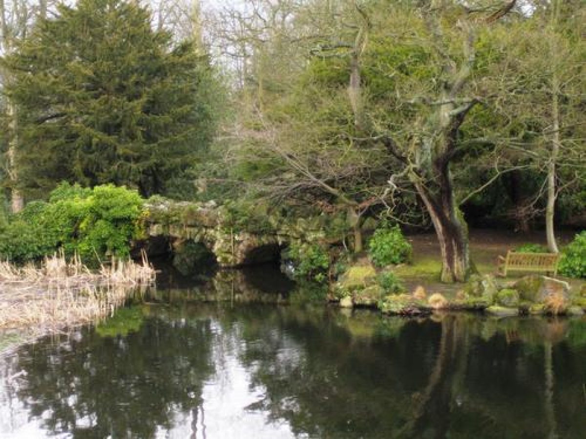
Paths lead west and north-west through the pleasure grounds to Boat House Pond, or Coffin Pond, c 450 m west of the Castle. There is a rustic bridge (listed grade II) designed by John Foss c 1813 at the north end of the pond and a ruinous boathouse on the shore immediately south of the bridge. A clump of yews beside the boathouse, c 500 m west of the Castle, shelters two stone coffins (listed grade II) set within an informal semicircle of large stones. The coffins are probably of Roman origin and were set out with the stones c 1835.
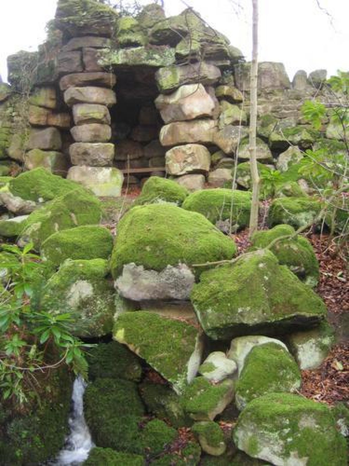
Paths continue from the rustic bridge through the woodland and run westwards to Lake Superior, c 1 km west of the Castle, which is the largest of a chain of lakes running south-east through woodland. The shores of the lake are irregular and they are embellished with substantial areas of rockwork made from massive boulders, some of which form promontories and islets. On the north side of the lake there is a large grotto, c 1.1 km west of the Castle, with a monolith bridging the path and alcoves set in rustic rockwork, from which views over the lake and the island within it can be obtained.
At the north-west tip of the site Quarry Gill Bridge (listed grade II) is a spectacular structure more than 20 m in height crossing a natural ravine and carrying the road from Swinton to Healey. At the base there is a rustic stone arch designed by Adam Mickle (1747(c 1815) and built 1811-13. Above this there is a series of three tall pointed arches surmounted by a crenellated parapet which was added by Foss following Mickle's death, and completed in 1822.
Two single-cell grottoes lie against the park wall c 1.2 km west of the Castle, to the south-east of Quarry Gill Bridge and west of the western tip of Lake Superior. They overlook a naturalistic cascade which flows into a small pond. Paths continue on the irregular south side of the lake, which has substantial rockwork edging, leading past a small hut built from roughly dressed stone, c 200 m east of the two grottoes. The lake narrows and at its south-east end it is crossed by a large rustic bridge. The paths continue alongside a series of smaller lakes, now (1998) partially silted up, and north-east of the southernmost lake, called Storth Pond, there is a rustic entrance from the park formed from large boulders, c 500 m south-west of the Castle.
The lakes had been formed for Sir William Danby the elder in the 1760s under the direction of a Mr Jones. Estate records show that plantations were also being formed at this time, and the landscape was described by Arthur Young in 1770 who writes of an 'elegant stream' and 'fine lakes' as well as mentioning cascades and groves (quoted in CL 1966). The transformation of this pastoral landscape to one characterised by irregularity with dramatic rockwork, rustic bridges and grottoes was the work of the younger Sir William Danby under the supervision of Adam Mickle in the years following 1796. Thirty thousand larch and pines were planted in 1803, and works to the landscape continued probably until the 1820s when Danby turned his attention to remodelling the house in Picturesque castellated style. A series of undated views by George Cuitt (reproduced in CL 1966) probably of the early C19, show the pleasure grounds well covered with mature trees with the lake, views of the Castle across the park and a root house which stood alongside the walk to Boat House Lake from the garden.
Danby, who owned landscape paintings by Claude, Poussin and Salvator Rosa, was a connoisseur and collector who had been on a grand tour between 1784 and 1790. After his return to Swinton, where the first phase of alterations to the house were prompted by the need to house his collections, he went on a tour of the Lake District in 1795. It seems likely that this trip and the aesthetic sensibilities which provoked it gave him the inspiration to create a wild and dramatic landscape at Swinton.
Kitchen Garden
The kitchen garden lies c 100m north-west of the Castle. It is walled with a range of bothies, sheds and ancillary buildings along the outer north wall. Some C18 and C19 varieties of apple trees survive within the garden which is largely in use for the cultivation of spruce trees (1998).
Park
The park lies south and south-west of the Castle. It is divided from the gardens by Home Lake, which is a serpentine stretch of water created in c 1760 by Sir William Danby the elder and modified by John Foss 1814-15. The park is enclosed on the remaining sides (apart from the southern edge where it is divided from a minor road by the park wall) by the wooded pleasure grounds from which it is divided by a substantial ha-ha wall. The open grassland of the park is well covered with scattered trees and clumps and it supports a herd of fallow deer. A C19 deer shelter shown on the 1856 OS map lies in the park c 40 0m south-west of the Castle.
Another area of parkland lies immediately south of Lake Superior, divided from the wooded pleasure grounds to the north-west by the remains of a ha-ha. Land rises to the south from the lake shore and the south boundary is sheltered by a tree belt. A folly called The Mount, probably of early C19 date, lies on the edge of this part of the park c 950m south-west of the Castle. It has an open arcaded ground floor from which views of the lake and surrounding woodland can be obtained.
Maps
- T Jefferys, County Map, 1771
- OS 6" to 1 mile:
- 1st edition published 1856
- 2nd edition published 1892
- 1930 edition
- 1956 edition
Description written: November 1998 Amended: March 1999
Register Inspector: CEH
Edited: October 1999
- Visitor Access, Directions & Contacts
Website
https://www.swintonestate.com/Access contact details
This is a spa and hotel. The site is now a hotel and open by appointment only.
For more detailed information visit the Swinton Park Estate website.
- History
The following is from the Register of Parks and Gardens of Special Historic Interest. For the most up-to-date Register entry, please visit the The National Heritage List for England (NHLE):
www.historicengland.org.uk/listing/the-list
HISTORIC DEVELOPMENT
The estate was acquired by the Danby family in the late 16th century when two-thirds of the manor of Swinton was bought by Elizabeth Danby. It passed to Abstrupus Danby in 1683 who consolidated it by purchasing the remaining third of the manor in 1688. It remained in the Danby family until 1882 when it was sold to Lord Masham. In 1924 it passed to the Cunliffe-Listers, and Sir Philip was created Viscount Swinton in 1935 and Earl of Swinton in 1955. The site is in private ownership (1998) apart from the Hall and part of the gardens which were given to the Conservative College after the Second World War and subsequently bought by a private company, in whose ownership they remain (1998).
Period
- 18th Century (1701 to 1800)
- Late 18th Century (1767 to 1800)
- Associated People
- Features & Designations
Designations
Area of Outstanding Natural Beauty
- Reference: Nidderdale
The National Heritage List for England: Register of Parks and Gardens
- Reference: GD2076
- Grade: II*
Features
- Rockery
- Icehouse
- Orangery
- Ornamental Pond
- Description: Coffin Pond
- Tree Avenue
- Description: A lime and yew avenue.
- Ornamental Lake
- Earliest Date:
- Latest Date:
- Boat House
- Ornamental Bridge
- Pond
- Description: A lily pond.
- Summerhouse
- Description: The summerhouse is located on an island on one of the lakes.
- Garden Seat
- Description: The druid's seat.
- Grotto
- Folly
- Description: The Mount.
- Deer House
- Earliest Date:
- Latest Date:
- Key Information
Type
Park
Purpose
Ornamental
Principal Building
Commercial
Period
18th Century (1701 to 1800)
Survival
Extant
Hectares
105
Open to the public
Yes
Civil Parish
Swinton with
- References
References
- {English Heritage Register of Parks and Gardens of Special Historic Interest}, (Swindon: English Heritage, 2008) [on CD-ROM] Historic England Register of Parks and Gardens of Special Historic Interest
- Pevsner, N., {The Buildings of England: Yorkshire The North Riding} (Harmondsworth: Penguin, 1966), pp. 363-4 The Buildings of England: Yorkshire The North Riding
- Country Life, 139 (7 April 1966), pp 788-92; (14 April 1966), pp 872-5; (21 April 1966), pp 944-8 Country Life, 139
- p 126 Days of Yore A History of Masham
Contributors
Nidderdale AONB Historic Parks and Gardens project