Introduction
Morden Hall was a moated garden in the late-18th century. This is set within a park created in the late-19th century, with associated landscaping for the adjacent snuff mill. The park has survived largely intact and includes a number of historic buildings. The former walled vegetable garden is now the main entrance to the public park.
Terrain
LevelThe following is from the Register of Parks and Gardens of Special Historic Interest. For the most up-to-date Register entry, please visit the The National Heritage List for England (NHLE):
A moated garden of the late 18th century, set within a park created in the late 19th century.
Location, Area, Boundaries, Landform and Setting
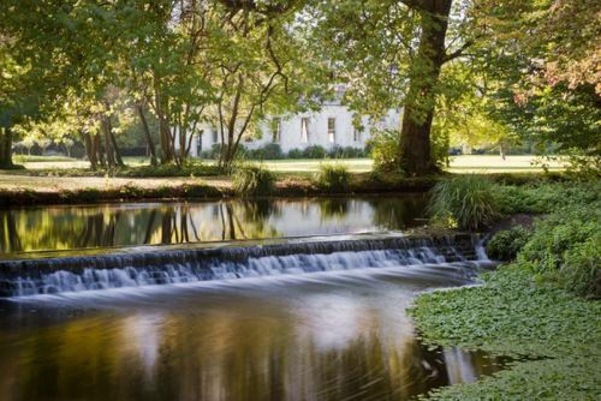
Morden Hall Park is located in urban south-west London and lies c 500m south of Merton, c 300m east of Morden, c 4km north of Sutton, and c 1.5km east of Mitcham. The boundaries of the roughly triangular site are formed to the north-east by the Croydon and Wimbledon Railway, constructed 1865, to the west by Morden Hall Road (A297), and to the south by Morden Road (A239). The c 38ha level site is crossed by a number of watercourses, all part of the River Wandle which runs north to the Thames.
Entrances and Approaches
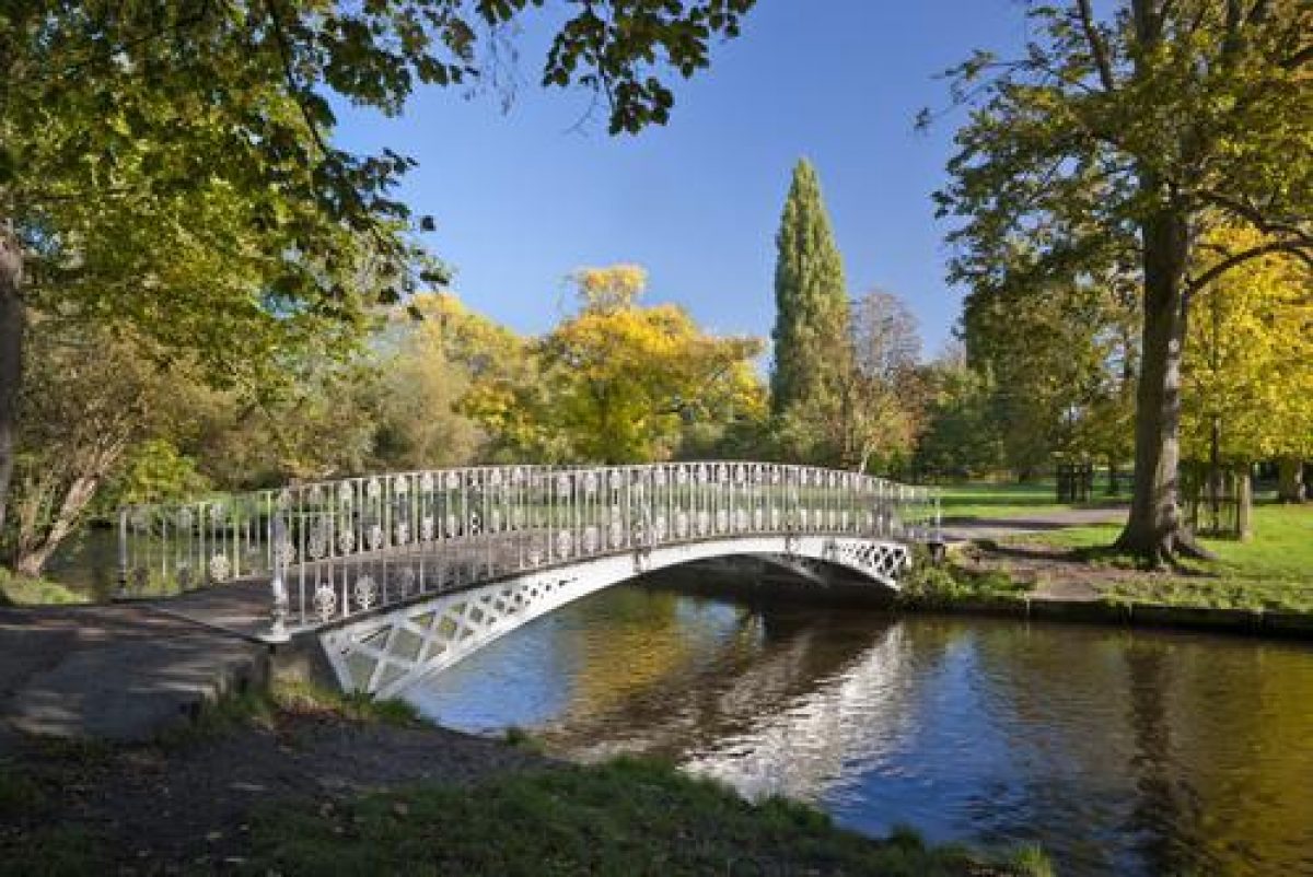
The main entrance into the park today (1999) is from the walled garden which now serves as a car park and has a number of commercial enterprises within its walls. The access is from Morden Hall Road, c 30m to the north of Morden Lodge. The main drive to the Hall, as made by Gilliat Hatfeild in 1873, still survives however as a footpath from South Lodge on Morden Road (OS 1895). Laid out as a tree-lined avenue, it takes a curving line across the centre of the park before turning west and continuing its approach to the Hall as a c 300m long formal avenue, crossing first the eastern branch of the River Wandle, then the eastern arm of the moat via two late C19 bridges (listed grade II).
There are three additional gateways in Morden Hall Road. The northernmost accompanies the Gate Lodge, a mirror image of South Lodge, 100m north-west of the Hall. This entrance was made by Hatfeild in 1873 as part of his improvements. The middle gate (with the wall to the north listed grade II) breaks the brick wall of the western boundary. This was the main entrance to the Hall before the formation of the park by Hatfeild and opened directly onto the turning circle which lay below the south front. The road from the gateway located c 120m further to the south on Morden Hall Road runs for c 150m between the leat parallel with the southern arm of the moat and the north wall of the kitchen garden, past the C19 stable block to the north and Morden Cottage to the south-east, before joining the drive to the east of the Hall.
Principal Building
Morden Hall (listed grade II) stands within a moated enclosure at the centre of the north/south axis of the estate, towards the western edge of the site adjacent to Morden Hall Road. The moat was created with water from the River Wandle and apparently dates from the mid C18 (Rocque 1746). Now (1999) used as a licensed restaurant, the two-storey villa was built between 1750 and 1765 by the fifth Richard Garth. Since 1780 the bow on the north front has been replaced with a plain porch and doorway and the south entrance has also been altered. The Hall was stuccoed in the mid C19 (Fretwell 1994). When G E Hatfeild died in 1942 the Hall, along with Morden Cottage and the kitchen garden, was let to Merton and Morden Urban Council. The Hall was extensively renovated in the 1990s.
Some 150m to the south-east of the Hall is Morden Cottage, a small separate house used in the late C20 as the borough Registry Office. Said to have been built in the C18 as a hunting lodge (ibid), it was the home of Gilliat Hatfeild before he purchased Morden Hall in 1873, and subsequently the home of his son. Its garden, which spans the River Wandle, is laid out as an irregular rose garden and remains largely unchanged since G E Hatfeild had it made in the 1920s.
Gardens and Pleasure Grounds
The c 2ha pleasure grounds are situated to the north, east, and south of the Hall and are contained within an C18 water-filled moat. The entrance to the Hall from Morden Hall Road turns south and leads to a court south of the Hall. This entrance was down-graded by Gilliat Hatfeild when he made the Gate Lodge entrance. The court, enclosed by railings, has a central fountain structure which probably, before 1950, stood further south, in the centre of the circular pool in the turning circle (ibid). The grounds within the moat are laid largely to grass with isolated trees including three large oriental planes which overhang the northern moat. The only surviving way across the moat is to the east of the Hall. There an ornate iron bridge (listed grade II), guarded on the Hall side by a gate and matching iron railings, provides access from the formal avenue. Hatfeild removed all the boundaries of the gardens to leave simple lawns sloping down to the moat. The lawns were punctuated with a few large trees and the existing fountain and formal walk were retained. The OS 1st edition map of 1866 shows a path leading south from the fountain or statue at the centre of the turning circle on the south front, across the south garden, then laid out as an orchard, dividing to cross the southern arm of the moat via two bridges.
Park
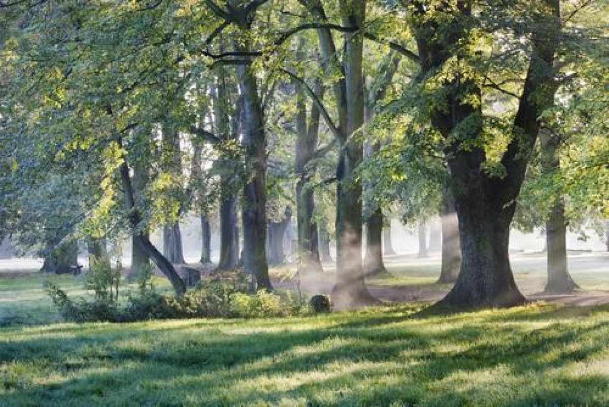
The c 35ha park lies to the north, east, and south of the pleasure grounds. The drive from Morden Road curves north across the park for c 400m before turning west towards the Hall. The southern part of the avenue which lines it is of roughly alternating lime and horse chestnut with a few ash and sycamore; the section to the north-west is of common lime. The large chestnuts are possibly survivors from the earlier field boundaries which Hatfeild removed when he created the park. The character of the park has changed from being a neat park set in countryside to, by the late C20, a rougher, more verdant area hemmed in by buildings. To the north-east and north the railway line is partly screened by the narrow boundary belt of mainly horse chestnut and common lime, with occasional hornbeam, London plane, tree of heaven, false acacia, and sycamore. Individual park trees and small clumps are scattered across the parkland and include a wide range of species.
The area to the south-west of the avenue is dominated by the River Wandle which enters the park at its most southerly point and immediately divides. The main branch, that to the east, continues for c 200m before dividing around an island known in 1840 as the Wilderness (Tithe map, 1840). After 100m it narrows and continues north. The western branch follows the south-west boundary of the park for c 150m before turning sharply north-east around the boundary of Morden Lodge (listed grade II). Morden Lodge (outside the area here registered), a brick Regency house, stands in its own grounds at the south-west corner of the park, near the site of an earlier house known as the Growets. The Lodge, which had become separated from the estate, was reunited in 1929 when G E Hatfeild purchased it but by 1999 it had returned to private ownership. The two branches of the river join up to the north of the island. The ground between the two branches of the river is (late C20) planted up as woodland or has been taken over by scrub which provides screening from the roads to the south. Now (1999) known as The Wilderness, the area was, in 1750, fields and osier beds with several small islands and was known as Stielhams and Mount Nod (Survey plan, 1750). In the early C19 part of the area was included in Morden Lodge Garden with walks connected by bridges, but later the area was leased out with the kitchen garden. After 1873 a connecting channel between Mount Nod and Stielhams was filled in and the area connected to the park by bridges, creating a circular walk ornamented with a statue of Neptune. A rectangular water body was filled in in the 1960s and at the same time the bridges were removed. The area is fairly inaccessible and is managed (1999) as a wildlife sanctuary.
The river continues north for c 50m before dividing once more; the western branch enters the kitchen garden at this point. The main branch continues north through the grounds of Morden Cottage, where it was formerly used to power two snuff mills, and after c 75m passes under the iron bridge that carries the avenue towards the Hall.
Some 50m to the north of the avenue the river divides again, the two leats running parallel in a north-easterly direction across the northern parkland before exiting the site under the railway line. The parkland to the north of the these pieces of water is open with only an occasional tree to break up the views towards the industrial buildings and residential developments of Merton. Hatfeild drained the marshy ground and planted it in keeping with the main body of the park. In 1926-7, spoil from the Northern Line extension (to Morden) was dumped onto this area with further tipping occurring during the period 1952 to 1955. Two additional water courses were filled in c 1950.
Kitchen Garden
The kitchen garden is situated c 150m to the south of the Hall, enclosed within high brick walls with stone capping (listed grade II). The c 1ha rectangular garden is orientated north/south. A channel of the River Wandle runs through the centre and a cast-iron clairvoie is set in the south wall. Hard car parking (first introduced in 1962) takes up much of the western half, with a garden centre to the east and a tea room in the north-west corner against the wall (both introduced 1991/2). An entrance between the tea room and the garden centre leads north onto the drive which leads from Morden Hall Road to Morden Cottage and the stables.
The kitchen garden was probably built at the same time as the Hall (late C18). For most of the C19 it was a tenanted market garden with four glasshouses and a central conservatory. Under G E Hatfeild the kitchen garden was managed as part of the estate, with fourteen gardeners employed in the 1920s producing food for the hospital, and a small surplus sold.
Brick buildings to the north of the kitchen garden which are now (1999) used as craft workshops and an information centre were originally potting sheds which were later converted to stables and cowsheds
Maps
- J Rocque, Plan of the Cities of London and Westminster and Borough of Southwark and the country near ten miles around, surveyed 1741-5, published 1746
- A survey of part of the River Wandle, 1750 (in Fretwell 1994)
- Tithe map for Morden parish, 1837 (in Fretwell 1994)
- Tithe map for Merton parish, 1844 (in Fretwell 1994)
- Tithe map for Mitcham parish, 1847 (in Fretwell 1994)
- OS 6" to 1 mile: 1st edition published 1883
- OS 25" to 1 mile: 1st edition published 1866
- 2nd edition published 1895
Description written: July 1999
Amended: September 1999
Edited: November 2001
- Visitor Access, Directions & Contacts
Telephone
02085456850Website
http://www.nationaltrust.org.ukAccess contact details
The park is open daily between 8am and 6pm throughout the year.
For more details visitor information visit the National Trust website.
Directions
The park is south of Wimbledon, off the A24 and A297. There are good public transport links by bus, rail and tube.
Owners
The National Trust
Heelis, Kemble Drive, Swindon, SN2 2NA
- History
The following is from the Register of Parks and Gardens of Special Historic Interest. For the most up-to-date Register entry, please visit The National Heritage List for England (NHLE):
16th Century
Until the Dissolution, the ground now occupied by Morden Hall Park was owned by the Abbey of Westminster. In 1553 the land was purchased by Messrs Duckett and Whitchurch, and in the following year the estate was brought by Richard Garth, the son of a successful lawyer and himself a clerk of the Petty Bay at Chancery. At this date the estate contained a 'newly built mansion house' known as Growtes which stood to the south of the present Hall, close to the present Morden Lodge (Fretwell 1994). The property was to remain in the Garth family until the late 19th century.
18th Century
Between 1750 and 1765, the fifth Richard Garth is said to have built the present Hall. Between 1782 and 1873 a number of tenants occupied the Hall, the last being Reverend J and Mr T White, who used the premises as 'a school for young gentlemen'. Meanwhile the kitchen garden was let separately to a succession of nurserymen.
19th Century
From 1867 Gilliat Hatfeild, the son of wealthy business man and a partner in the firm which ran the Morden snuff mill, began to buy up parts of the Garths' Morden estate and negotiated to buy the Hall. Hatfeild had been brought up on the estate at Morden Cottage, next to the snuff mills. After finally purchasing the Hall in 1873, he went on to create a park from land surrounding the Hall, removing field boundaries and demolishing cottages. The east and west boundaries were planted up with narrow fringes of trees, while trees from the former boundaries were retained as park trees and small clumps and single trees were planted across the open parkland to supplement them, giving a park of mainly chestnuts and willows. The main feature of the new park was a tree-lined drive from the Hall to the new South Lodge in Morden Road. Few changes were made to the existing watercourses but several new bridges were erected to carry the drive and paths across them. Hatfeild also made minor alterations to the Hall gardens, and built a new stable block and new lodges. The 40 hectare park was described in 1892 as being fenced with oak paling and stocked with about 100 fallow deer.
20th Century
Gilliat Hatfeild died in 1906 and his son Gilliat Edward (G E) Hatfeild inherited and returned from Virginia to run the estate. During the First World War Hatfeild loaned the Hall to the London Hospital as a convalescent home for military patients. He himself moved into Morden Cottage. After the war the Hall was used as a convalescent home for women and children, funded by Hatfeild and run by the Salvation Army. The garden, especially the kitchen garden, continued to be maintained to a high standard. His only major alteration to the park landscape was to lay out a rose garden around Morden Cottage. When G E Hatfeild died in 1942 he left Morden Hall and the park to the National Trust in order to preserve it intact but it was not until about 1980 that the Trust took over the direct management of the estate. In the meantime the Hall was leased to the local authority and cattle replaced the deer, grazing continuing until 1972.
In 1991-1992 the kitchen garden was converted from a nursery to a garden centre with a tea room and car park. The management of the park changed to reflect its 'green lung' status and importance for education. Today (1999) the site continues under the ownership and management structure developed since 1980.
- Features & Designations
Designations
Conservation Area
- Reference: Wandle Valley
The National Heritage List for England: Register of Parks and Gardens
- Reference: GD 2608
- Grade: II
The National Heritage List for England: Listed Building
- Reference: middle gate
- Grade: II
The National Heritage List for England: Listed Building
- Reference: Morden Cottage
- Grade: II
The National Heritage List for England: Listed Building
- Reference: Morden Hall
- Grade: II
The National Heritage List for England: Listed Building
- Reference: snuffmills
- Grade: II
The National Heritage List for England: Listed Building
- Reference: stone statues of Venus & Cupid and Neptune
- Grade: II
Site of Local Importance for Nature Conservation
Features
- House (featured building)
- Earliest Date:
- Latest Date:
- Rose Garden
- Description: The rose garden has recently been restored.
- Earliest Date:
- Latest Date:
- River
- Description: River Wandle
- Moat
- Earliest Date:
- Ornamental Bridge
- Earliest Date:
- Avenue
- Earliest Date:
- Kitchen Garden
- Building
- Description: Two water mills were used to grind tobacco.
- Earliest Date:
- Latest Date:
- Stable Block
- Earliest Date:
- Drive
- Key Information
Type
Park
Purpose
Ornamental
Principal Building
Education
Survival
Extant
Hectares
41.06
Open to the public
Yes
- References
References
- {English Heritage Register of Parks and Gardens of Special Historic Interest} (Swindon: English Heritage 2008) [on CD-ROM] Historic England Register of Parks and Gardens of Special Historic Interest
- Fretwell, Katie {Morden Hall Park: Park and Garden Survey} (1994) Morden Hall Park: Park and Garden Survey
- Land Use Consultants {Morden Hall Park Conservation Management Plan} (2007) Morden Hall Park Conservation Management Plan
- Walford, E., (1884) Greater London: a narrative of its history, its people and its places
- Jowell, E, M., (1951) The History of Merton and Morden
Contributors
London Parks and Gardens Trust