Introduction
Dunster Castle has gardens and woodland on the castle hill. The gardens cover approximately 6 hectares, set within a park of 277 hectares. It was originally a medieval site, with re-workings in the mid to late-18th century and the mid-19th century.
Terrain
Hilltop
The following is from the Register of Parks and Gardens of Special Historic Interest. For the most up-to-date Register entry, please visit The National Heritage List for England (NHLE):
The 18th and 19th-century terraced gardens, partly on medieval castle defences, in a mid and late 18th-century landscape park laid out with the advice of Richard Phelps, on the site of a medieval park.
Location, Area, Boundaries, Landform and Setting
Dunster Castle is situated c 2.5km south-east of Minehead, to the south of the A39 road. The c 283ha site comprises some 6ha of gardens and pleasure grounds around the Castle, and c 277ha of park. To the north-east the site is bounded by the A39 road, the mid C20 course of which has detached a mixed plantation, Great Firs, from the park. To the east-north-east the site adjoins agricultural land, while to the east and south-east the boundary is formed by a minor road, Park Lane, from which the site is separated by banks and hedges. To the south the site is separated from adjacent agricultural land and woodland by a track which extends west from Park Lane to Bonniton Lane, which forms the western boundary of the site.
To the north the site adjoins meadows to the south of the River Avill, while the north-west boundary is formed by Gallox Lane, the River Avill, and the boundaries of domestic properties in the village of Dunster. The site is separated from these properties by brick and stone walls. The registered site includes three outlying areas: Great Firs plantation to the north-east; the site of the Castle kitchen garden, now Village Gardens, to the east and north-east of the village church; and Conygar Wood, c 450m north of the Castle, which occupies a prominent hill and forms the setting for Conygar Tower, a mid C18 folly. The site is undulating and is crossed from north-west to north-north-east by the River Avill.
To the north-west of the river is the Tor, a conical-shaped hill on which the Castle stands and commands wide views in all directions across the village, the park and surrounding countryside, and the coast c 2km to the north. The park rises to the east and south, while a further conical hill, Conygar Hill to the north of the village, allows reciprocal views to the Castle.
Entrances and Approaches
The principal approach to the Castle is from the A39 road to the north-north-east at a point c 80m north-west of Loxhole Bridge over the River Avill. The entrance is marked by a simple timber gate flanked by metal railings, which leads to a tarmac drive extending c 450m south-west across the park.
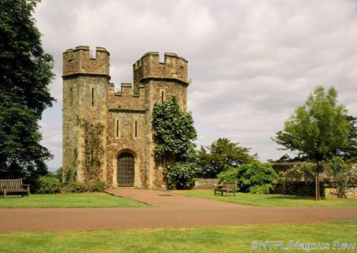
The ground to the south-east of the drive falls away towards the River Avill, allowing easterly views across the park. Passing to the south-east of a late C20 visitors' car park, the drive enters the pleasure grounds c 100m north-east of the Castle, where it divides, one branch continuing to form the principal drive to the summit of the Tor, the other leading west to reach a gatehouse (C15, listed grade I), stables (mid C17, listed grade II*), and a C19 service yard situated between Castle Hill and Church Street (stables and yard situated outside the area here registered). To the north of the stables, Castle Hill forms a drive leading to an entrance comprising a timber gate at the southern end of High Street, and a further entrance at the northern end of West Street.
The main drive sweeps south and south-west before turning north-west and north to ascend the Tor in a spiral. The outer side of the drive is marked by low clipped laurel hedges which allow a series of contrasting views across the park and the wooded River Avill valley, while the inner side of the drive is marked by rubble-stone walls which retain the upper slopes of the Tor. Turning east, the drive emerges into a level area of lawns, the Green Court, with a carriage turn below the west façade of the Castle. The Green Court is bordered to the north and north-west by the early C15 gatehouse, stone walls which survive from the medieval curtain wall demolished in the mid C17, and the ruins of a further medieval tower, while to the west it is bordered by trees and evergreen shrubbery. To the south the steep, north-facing slope of the upper Tor is planted with further trees and evergreen shrubbery. There are designed views from the Green Court west across the village of Dunster, north-west to the Conygar Tower, and north to the Bristol Channel.
The drive was constructed as part of the improvements associated with Salvin's remodelling of the Castle in 1868-72 and runs parallel and at a lower level to the course of an early C18 drive begun by Dorothy Luttrell in 1720 and completed by Henry Fownes Luttrell in the mid C18. This earlier drive survives as the lower garden walk and is shown in an engraving of 1733 (Buck) when it led to an entrance at the south-east corner of the Castle. The Green Court was constructed in 1764 by Henry Fownes Luttrell on the site of the medieval lower ward, an artificially raised and levelled area which is retained to the north by the remains of a medieval curtain wall that was largely demolished in the mid C17, and by Salvin's late C19 single-storey service wing. A drawing by J Buckler (1839) shows the drive enclosing a central lawn within the Green Court; this arrangement appears to have been modified in the late C19 when Salvin remodelled the west façade of the Castle.
To the south of the Castle, an entrance leads from the east end of Mill Lane to the pleasure grounds. This entrance (listed grade II* with Castle Mill) comprises a gothic arch closed by wrought-iron gates, which is set in a rubble-stone wall extending from the south-east corner of Castle Mill. Constructed in stone and surmounted by a lancet opening and a carved stone finial, this entrance was formed c 1782 by Henry Fownes Luttrell, probably with the advice of Richard Phelps, when the mill was rebuilt as a gothic picturesque eyecatcher in his scheme for improving the setting of the Castle; it is depicted in its present form in a watercolour of 1796 by the Rev John Swete (Gray 1999). It occupies the site of a mill which was in existence by 1086 (guidebook).
Some 1.5km south-west of the Castle, an entrance leads from Bonniton Lane to the park. The entrance is marked by a mid C19 two-storey stone lodge (listed grade II) constructed in Picturesque style with tiled roofs and an off-centre porch. The lodge stands on the site of an early C18 toll-house and incorporates a stone tablet dated 1708 from the earlier structure. The toll-house fell into disuse in the late C18 when the park was extended by Henry Fownes Luttrell and the road diverted. Carhampton Gate, c 950m south-east of the Castle, leads to the park from Park Lane. There are further informal entrances to the park from the track which forms its southern boundary.
Principle Building
Dunster Castle (scheduled ancient monument; listed grade I) stands on a levelled terrace on the east side of the Tor, which is situated towards the north corner of the site, overlooking the estuary of the River Avill. The Castle is constructed in red sandstone under lead and slate roofs, concealed by crenellated parapets. It has an irregular outline with the skyline punctuated by towers to the north-west, north-east, and south-east. The entrance or west façade has an off-centre porch approached by a flight of stone steps and surmounted by a monumental relief carving of the Luttrell arms; it is flanked to the north by a four-storey tower and five-storey turret, and to the south by an irregular block comprising three and four storeys.
The garden or east façade is similarly irregular in plan, with a two-storey semicircular tower to the north-east, an off-centre four-storey tower, and a further two-storey range incorporating a semicircular turret. The Castle assumed its present form in 1868-72 when an existing building was extensively remodelled by Anthony Salvin who also remodelled Thornbury Castle, Avon (qv), providing the Castle with a picturesque gothic exterior and additional accommodation in two towers and a service wing (CL 1987). The building which forms the core of the C19 Castle was built in 1617 by William Arnold (d c 1636), a master builder who had previously worked at Cranborne Manor, Dorset (qv), Montacute House, Somerset (qv), and Wadham College, Oxford (qv). Arnold's early C17 house incorporated elements from the medieval castle, which were in turn retained by Salvin in the late C19 rebuilding (guidebook).
Gardens and Pleasure Grounds
The gardens and pleasure grounds are situated on the steep north and east-facing slopes below the Castle, with a further area on the upper slopes of the Tor to the south-west of the Castle. The north and east-facing slopes below the principal drive are laid out with a network of informal walks passing through C19 and early C20 specimen trees and conifers which are underplanted with an extensive C20 collection of ornamental shrubs, many being tender species which benefit from the site's coastal climate.
A wide gravelled walk extends parallel to the river, leading south and south-west from the Castle for c 200m to reach the Mill Lane entrance. Some 20m east of the mill, a picturesque two-arched stone bridge (Phelps C18, listed grade II) with a rock-faced parapet and rusticated voussoirs crosses the River Avill, leading to an area of late C20 informal pleasure grounds east of the river which is separated from the park by a low clipped holly hedge (OS 1904). Some 100m north-east of Castle Mill Bridge, the river is crossed by a late C20 metal footbridge, while c 200m north-east of Castle Mill Bridge, the river is crossed by Lawns Bridge (Phelps late C18, listed grade II), a three-arched rusticated stone structure incorporating an ornamental cascade which provides access to the park. It replaced an earlier structure shown in Buck (1733) and was described in its present form by the Rev John Swete in 1796 (Gray 1999).
Some 50m north of Lawns Bridge, a serpentine gravel walk, the Fuchsia Path, ascends the east-facing slope, turning sharply south-west adjacent to a spring contained in a stone recess. Crossing the drive c 100m south-east of the Castle, the Fuchsia Path continues for a further c 50m before joining a gravelled walk which follows a contoured route from a late C19 wrought-iron gateway opposite the stables, round the north and east sides of the hill to reach the east terrace at the south-west corner of the Castle. The slope below this walk is planted with ornamental trees and shrubs, while the upper slope, which is retained by low drystone walls, is planted with shrubs and, below the east terrace, a group of dome-shaped clipped yews. This path corresponds to a drive developed in the early C18 by Dorothy Luttrell and completed in the mid C18 by Henry Fownes Luttrell, shown in Buck (1733).
At the south-west corner of the building an arch leads north-east to connect the terrace with the Green Court, at the same time separating the main Castle structure from a single-storey gothic orangery (Salvin, late C19) which is built against the south-east-facing slope of the Tor. A lawn with an oval flower bed and a central circular pool containing a lead fountain in the form of a boy riding a swan extends in front of the Orangery. The outer side of the terrace and the south-west end of the lawn are planted with mature Chusan palms. Near the south-west corner of the Castle, a pair of tall stone niches, perhaps intended as seats, stand against the building; these features are similar in form to structures found at other houses designed by William Arnold in the early C17 including Montacute House, Somerset (qv).
A gravel walk on a terrace retained by low crenellated parapets extends below the east façade of the Castle. It is terminated to the north by a flight of stone steps which descends to a further terrace, enclosed by a clipped holly hedge, below the north façade of the building. Recesses between the east walk and the Castle are planted with ornamental shrubs and tender subjects, including, to the north-west, a mature lemon which is trained against the Castle wall and protected in winter by a timber and glass case, described by James Savage in 1830 (Savage 1830). There are wide views from the east and north terraces across the park to the east and south-east, and north towards the coast. The north terrace descends gently north-west for c 150m to reach an early C15 gatehouse, beyond which lie C17 stables. From the gatehouse a stone staircase ascends south adjacent to a C13 gateway to reach the Green Court. The north and east terraces appear to have originated as part of the medieval defences and were adapted in the early C17 when the medieval buildings in the lower ward were rebuilt by William Arnold. The existing ornamental layout of the terraces was part of the scheme of improvements undertaken by Salvin for George Luttrell (OS 1904).
A walk extending from the south-east end of the east terrace leads west for c 100m along the south-facing slope of the Tor before dividing, one branch sweeping round the lower flank of the Tor to reach a small, late C19 pets' cemetery and thence the main drive c 150m west of the Castle, the other branch forming a spiral walk ascending to the summit of the Tor through specimen trees and evergreen shrubbery. The summit of the Tor comprises an approximately elliptical-shaped level terrace enclosed by a low perimeter brick wall. Within the wall a gravel walk allows views across the park, the river valley, the village, Conygar Hill, and the Bristol Channel.
An elliptical-shaped lawn or bowling green is separated from the perimeter walk by deep herbaceous and shrub borders. To the east-north-east of the lawn is an octagonal summerhouse or gazebo (1727, listed grade II) constructed in brick with a flat lead roof and an elaborate wrought-iron weathervane. A sloping walk, partly broken by short flights of steps, descends from the bowling green adjacent to the summerhouse, emerging on the lower walk c 80m west of the southern end of the east terrace. The slopes of the Tor were formerly bare except for single lines of trees to the north and south (Buck, 1733). A mid C18 painting of the Castle (National Trust Collection; CL 1987) shows the southern and eastern flanks of the Tor terraced, perhaps for the cultivation of fruit or vines (guidebook). By the early C19 the Tor appears to have been developed in its present form (Savage 1830).
Park
The park is situated to the north-east, east, south, and south-west of the Castle, the north corner being crossed from south-west to north-east by the river which is retained by an ornamental weir c 400m north-east of the Castle. The park is in mixed agricultural use (2002), with the majority of the land being pasture, heath, or mixed ornamental plantation. To the north of the river, the ground rises towards the north drive and retains scattered ornamental trees. This area is known as the Hanger Park or Old Park and is on the site of the medieval deer park created by the de Mohun family (Bond 1998). Generally level ground to the east of the river, known as The Lawns, is bounded to the east by Skewer Clift Wood which is situated on a steep north-west-facing slope, and to the south by Henstey Wood on a steep north-facing slope. A late C20 avenue of oaks extends north-west from Henstey Wood to Lawns Bridge, replacing an earlier avenue of elms which was noted by the Rev Swete in 1796 (Gray 1999). The Lawns are divided by C20 fences to form a series of paddocks and early C20 polo fields which are overlooked from the north by the early C20 single-storey Polo Bungalow, beyond which stands the early C20 Home Farm. The Lawns were imparked by the early C16 and were developed as an ornamental landscape in the mid and late C18.
To the south and south-east of the Castle and the Lawns, the park is more undulating and retains many scattered trees. Some 500m south of the Castle the character of the park changes, with extensive areas of mixed ornamental plantation and heathland. This area includes two prominent hills surmounted by ancient encampments, Gallax Hill, c 1km south-west of the Castle, and Bat's Castle, c 1.3km south-south-west of the Castle, together with a track which is the remains of a medieval road leading from Gallox Bridge, 350m south-west of the Castle, to Timbercombe. This road was closed c 1755 when the park was extended by Henry Fownes Luttrell. The mid C18 park was enclosed by a pale fence and was stocked with deer driven from a park at Marshwood to the north of Dunster, which also belonged to Henry Fownes Luttrell (Bond 1998).
Kitchen Garden
The kitchen garden which served the Castle is situated c 350m to the north-north-west, to the north of Church Street and to the east of the parish church of St George. The garden is known as the Village Gardens and comprises two approximately rectangular walled enclosures (listed grade II). The southern enclosure is separated from Church Street by a brick wall c 3m high, and is enclosed to the north and west by further brick walls and to the east by a stone wall. An arched entrance with wrought-iron gates in the southern boundary wall provides access to a box-edged walk which extends c 60m north to reach a further doorway leading to the northern enclosure. To the west, the walk is flanked by an herbaceous border, while to the east a further border and some mature espalier apple trees separate it from an area of lawn, at the south-east corner of which stands a mature mulberry. The northern garden is enclosed by brick walls and is laid to grass (2002). The north wall retains traces of lean-to glasshouses, while an opening at the north-east corner of the garden leads to a further enclosure, outside the area here registered. A further opening at the north-west corner of the garden leads to Priory Green.
The site of the kitchen garden formed part of the endowment of Dunster Priory, which was founded by William de Mohun in the late C11. In 1543 the land was acquired by Lady Margaret Luttrell, and was subsequently developed as the kitchen garden for the Castle, in which use it remained until the mid C20. In the late C20, ownership of the site was conveyed to the village of Dunster for use as a public garden.
Other Land
Conygar Wood, c 500m north of the Castle, is included in the registered site. It is a mixed ornamental plantation containing mature stone pines, Scots pines, sweet chestnuts, and oaks underplanted with yew and holly, and is situated on a steep-sided conical hill. Walks within the wood allow views across the village to the Castle and park, and towards the coast. The walks ascend to the summit of the hill, towards the southern end of which stands the Conygar Tower (Phelps 1775, listed grade II), a circular, three-storey crenellated stone tower lit by tall gothic windows. The structure is roofless and appears never to have been covered-in or provided with stairs, serving only as an eyecatcher from the Castle and park. The Rev Swete noted the tower in 1796, lamenting its incomplete state and the absence of an upper prospect room (Gray 1999). At the western end of Conygar Hill, a substantial picturesque gateway (Phelps, late C18) comprising two arches with flanking walls and two circular bastions survives in undergrowth (Headley and Meulenkamp 1989).
Maps
- J Speed, Somerset-shire Described, 1610
- OS 6" to 1 mile: 2nd edition published 1904
Description written: November 2002
Edited: July 2021
- Visitor Access, Directions & Contacts
Telephone
441643821314Access contact details
The gardens are open every day between March and December. Visit the National Trust website for more information regarding opening.
Directions
The site is accessible from the A39. It is in Dunster, 3 miles from Minehead.
Owners
The National Trust
Heelis, Kemble Drive, Swindon, SN2 2NA
- History
The following is from the Register of Parks and Gardens of Special Historic Interest. For the most up-to-date Register entry, please visit The National Heritage List for England (NHLE):
12th - 15th Century
Following the Norman Conquest, a Saxon fortress at Dunster was granted to William de Mohun. His son, also William (died around 1155), rebuilt much of the Castle’s defences in stone, enabling it to withstand a siege by King Stephen’s troops in 1138. The lower ward of the Castle was enlarged and strengthened by Sir Reynold de Mohun (died around 1257).
In 1378, Lady Joan de Mohun, the widow of Sir John de Mohun (died 1375), sold the property to Lady Elizabeth Luttrell (died 1395), wife of Sir Andrew Luttrell of East Quantoxhead, Somerset. Following Lady de Mohun’s death in 1404, Lady Luttrell’s son, Sir Hugh, took possession of the Castle in 1405. He repaired and improved the building, and in 1420 built a new gatehouse. The Luttrells were deprived of their estates by Edward IV in the mid-15th century, and remained dispossessed until the accession of Henry VII, when Dunster was restored to Sir Hugh Luttrell (died 1521).
16th - 18th Century
Sir Hugh’s great-grandson, Sir George, who inherited Dunster in 1571, made significant changes to the Castle, employing William Arnold in 1617 to build a new house in the lower ward. During the Civil War the Castle was surrendered to the Crown by Thomas Luttrell in 1643, and was later besieged by Parliamentary forces in 1645-6. Following the discovery of a Royalist plot centred in Somerset, Parliament ordered the demolition of the Castle defences, leaving only the early 17th-century house in the lower ward intact (Lyte 1882; Lyte 1909; guidebook).
In 1680, Dunster was inherited by Col Francis Luttrell, who was married to Mary Tregonwell, heiress to Milton Abbas, Dorset (see description of this site elsewhere in the Register). They restored and improved the house until Col Luttrell’s death in 1690, when the estate passed to his younger brother, Alexander (1663-1711). His widow, Dorothy, made significant improvements to the setting of the Castle during the minority of their son, including levelling the keep to form a bowling green, and making a new drive (Country Life 1987; guidebook). This son, also Alexander, died in 1737 leaving an only daughter, Margaret Luttrell (172-66), aged eleven. In 1747 she married her second cousin, Henry Fownes (1723-80) of Nethway, Devon, who assumed the additional name Luttrell. He continued the work begun by Dorothy Luttrell, completing the new approach to the Castle, forming a deer park to the south of an existing park, and building a series of Gothic follies in the garden and park with the advice of the artist Richard Phelps (CL 1987; guidebook; Headley & Meulenkamp 1989).
Henry Fownes Luttrell was succeeded in 1780 by his son, John (died 1816), who left Dunster to his son, also John. When John Luttrell died unmarried in 1857, the estate passed to his younger brother, Henry, who died in 1867 and was succeeded by his nephew, George Luttrell (1826-1910) who commissioned Anthony Salvin (1799-1881) to remodel and extend the house in 1868.
20th Century
George Luttrell died in 1910 and was succeeded by his son, Alexander (1855-1944). From 1920 the Castle was occupied by Alexander Luttrell’s son, Geoffrey (1887-1957), who sold the freehold to the Ashdale Property Company in 1944. The freehold was later acquired by the Crown Commissioners, who in 1954 sold the Castle and part of the park back to Geoffrey Luttrell. When he died in 1957, the Castle and remaining portion of the park passed to his son, Lt Colonel Walter Luttrell MC, who in 1976 presented the property to the National Trust (guidebook).
21st Century
The site remains in divided ownership, the Castle and its immediate grounds being the property of the National Trust and the remainder belonging to the Crown Commissioners.
- Associated People
- Features & Designations
Designations
The National Heritage List for England: Register of Parks and Gardens
- Reference: GD1436
- Grade: II*
Features
- River
- Ornamental Bridge
- Garden Seat
- Pond
- Orangery
- Summerhouse
- Specimen Tree
- Description: National Collection of strawberry trees
- House (featured building)
- Description: Jacobean country house
- Earliest Date:
- Latest Date:
- Key Information
Type
Estate
Purpose
Ornamental
Principal Building
Domestic / Residential
Survival
Extant
Hectares
283
Open to the public
Yes
Civil Parish
Dunster
- References
References
- {English Heritage Register of Parks and Gardens of Special Historic Interest}, (Swindon: English Heritage, 2008) [on CD-ROM] Historic England Register of Parks and Gardens of Special Historic Interest
- Bond, J., {Somerset Parks and Gardens} (Tiverton: Somerset Books, 1998), pp. 54-5, 94 Somerset Parks and Gardens
- Pevsner, N., {The Buildings of England: South and West Somerset} (Harmondsworth: Penguin, 1958), pp. 156-9 The Buildings of England: South and West Somerset
- {Victoria History of Somerset, Volume 2} ([n.p.]: Constable, 1911), p. 567 Victoria County History: Somerset, Volume 2
- Colson Stone Partnership {Dunster Castle Deer Park: Historical, Archaeological & Landscape Assessment} Dunster Castle Deer Park: Historical, Archaeological & Landscape Assessment
- Buck, S, and N, (1774) Buck's Antiquities II
- Collinson, J., (1791), p 13 The History and Antiquities of the County of Somersetshire II
- Savage. J., (1830) A History of the Hundred of Carhampton
- Sir, Maxwell Lyte, H. C., (1882) Dunster and its Lords 1066-1881
- Sir, Maxwell Lyte, H. C., (1909) A History of Dunster and of the families of Mohun and Luttrell
- Headley, G., and Meulenkamp, W., (1989), pp441-2 Follies, Grottoes and Garden Buildings
- Country Life 14, (14 November 1903), pp 686-95; no 29 (16 July 1987), pp 124-7; no 30 (23 July 1987), pp 102-06; no 22 (31 May 1990), pp 152-5 Country Life
- Gray, T., (Editor) 1789-1800 III, (1999), pp 62-8 Travels in Georgian Devon: The illustrated journals of the Reverend John Swete
- 18 (1842), p 489 The Gardener's Magazine
- Related Documents
-
CLS 1/659
A Survey of the Historic Landscape, Vol 1: Development and Analysis - Hard Copy.
Kate Felus & John Phibbs, Debois Landscape Survey Group - 2004
-
CLS 1/660
A Survey of the Historic Landscape, Vol II: Historic Sources and Fieldwork & Other Background Material, Book I - Hard Copy.
Kate Felus & John Phibbs, Debois Landscape Survey Group - 2004
-
CLS 1/661
A Survey of the Historic Landscape, Vol II: Historic Sources and Fieldwork & Other Background Material, Book II - Hard Copy.
Kate Felus & John Phibbs, Debois Landscape Survey Group - 2004
-
CLS 1/659