Introduction
Crowcombe Court has a walled garden of around 1 hectare and a landscape park of around 94 hectares. It was laid out from about 1723. Early 18th-century gardens and parkland which were remodelled in the second half of the 18th century with Picturesque walks and a group of follies. The house is now a wedding venue.
Terrain
The site slopes steeply from north-east to south-west, with a steep-sided wooded combe extending from north-east to south-west c 300m north of the house. The ground also falls towards the eastern boundary.The following is from the Register of Parks and Gardens of Special Historic Interest. For the most up-to-date Register entry, please visit The National Heritage List for England (NHLE):
Location, Area, Boundaries, Landform and Setting
Crowcombe Court is situated to the north-east of the village of Crowcombe, c 200m north of the parish church. The c 95ha site comprises some 5ha of gardens and pleasure grounds, and c 90ha of parkland and ornamental plantations. To the south the site adjoins the village street and the churchyard associated with the parish church, from which it is separated by stone walls, while to the south-east the boundary is formed by hedges separating the park from a minor road leading from Crowcombe to Nether Stowey. The boundaries to the east, north and west are similarly formed by hedges, banks, and ditches which separate the park from adjoining heath and agricultural land. The site slopes steeply from north-east to south-west, with a steep-sided wooded combe extending from north-east to south-west c 300m north of the house. The ground also falls towards the eastern boundary, which follows the line of Crowcombe Combe. There are extensive views south, west, and north-west from the upper areas of the park across surrounding agricultural land and north-west towards the north Somerset coast. There is also a significant view north from the village street adjacent to the church towards the south façade of the house.
Entrances and Approaches
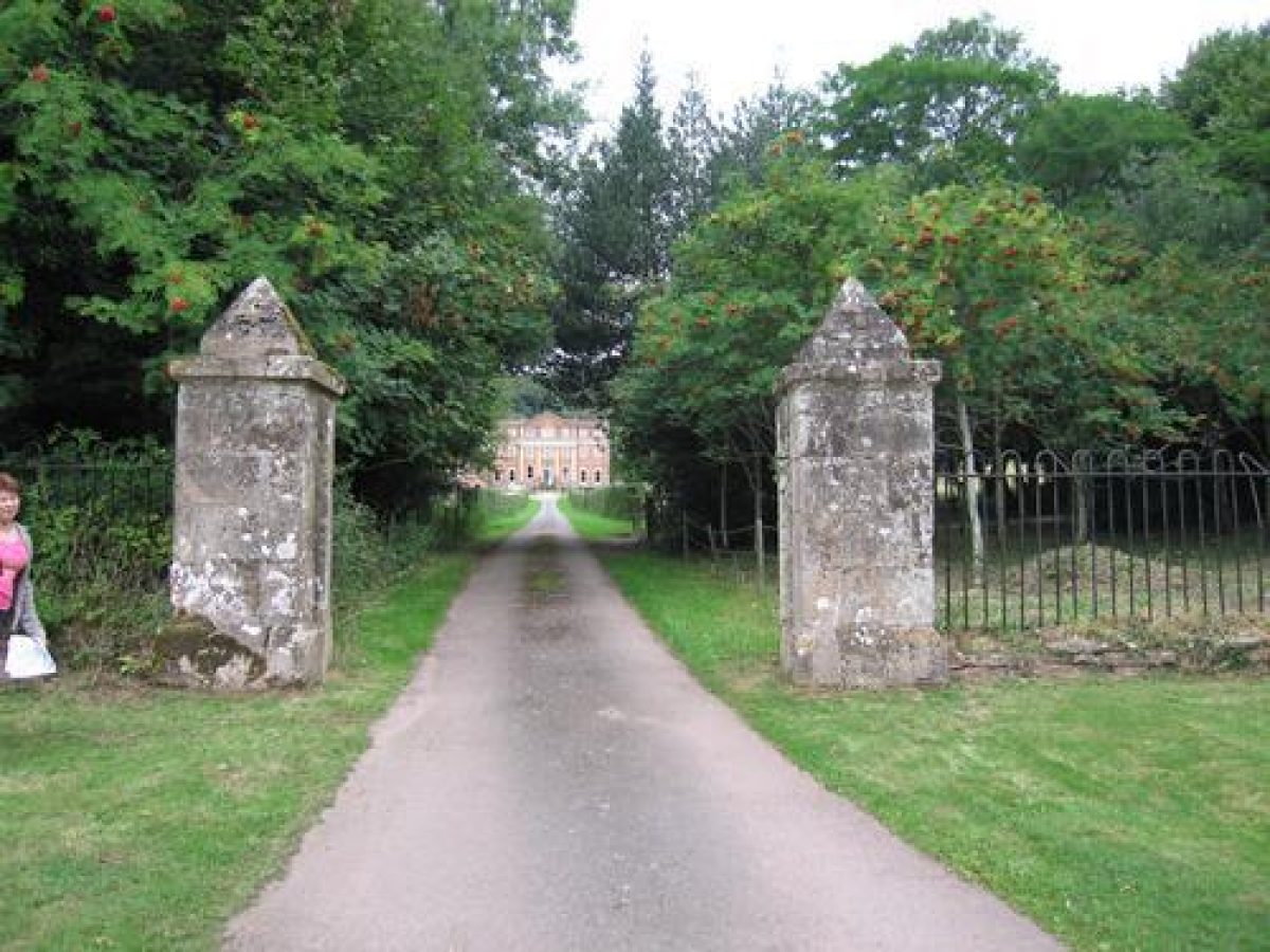
Crowcombe Court is approached from the village street to the south, at a point immediately west of the parish church. The entrance comprises a pair of square ashlar piers under pyramidal caps which are flanked to east and west by low stone walls surmounted by spear-headed wrought-iron railings. From the entrance the tarmac drive follows a straight course c 170m north-north-west to reach a gravelled forecourt with geometrical panels of lawn below the south façade of the house. The drive is adjoined by narrow grass verges and mixed hedges which separate it from the park to the east, and an area of orchard and kitchen gardens to the west. A service drive follows the south-west boundary of the site, leaving the village street at a point c 150m west of the principal entrance and extending c 200m north-north-west to reach the monumental stable court below the west façade of the house (listed grade I with Crowcombe Court). The service drive is adjoined to the east by C18 brick walls enclosing the west side of the kitchen garden.
A further entrance to the site is situated on the north-east boundary at a point c 300m north-north-west of Crowcombe Combe Gate on the minor road forming the south-east boundary of the park. Approached from the road by a track, this entrance, known as Crowcombe Park Gate, comprises a pair of square rendered piers under flat caps which support a timber carriage gate. A single-storey Gothic-style lodge, probably of late C18 or early C19 construction (extended C20), stands immediately west of the entrance. From the entrance, a contoured track sweeps south-west and west-south-west through an avenue of mature beech before entering an area of woodland. It formerly continued south-west and south to reach the north side of the house, but no trace of the drive survives within the pleasure grounds (2003).
Principal Building
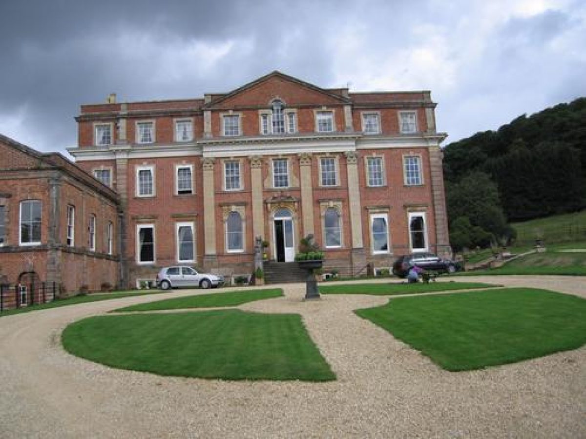
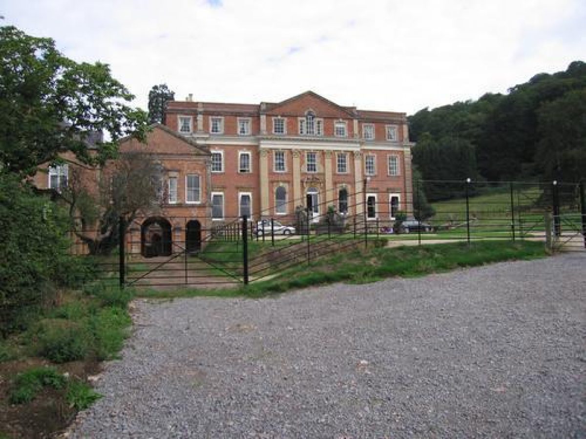
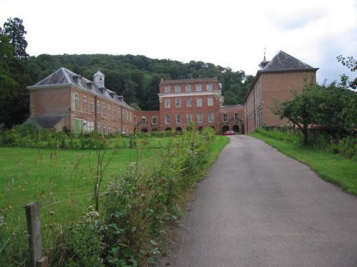
Crowcombe Court (listed grade I) stands on a level site below the south-west-facing wooded slope of the park, adjacent to the south-west boundary of the site. The house comprises two storeys and an attic and is constructed in red brick with Bath and local stone dressings under a principally lead roof concealed behind parapets. The south or entrance façade has a monumental, centrally placed pediment rising above the line of the parapet, with a central Venetian window lighting the attic. The pediment is supported by giant pilasters surmounted by composite capitals. The centrally placed door is approached by a flight of balustraded stone steps. The north façade is of similar design, while the east façade is plainer. The west façade overlooks the stable court. A rusticated arcade gives access to the basement at ground level due to the slope of the land, while similarly arcaded quadrant wings connect the house to the two-storey stable block to the south of the court and the kitchen block to the north, both of which have integral coach houses. Monumental pedimented arches lead south-east to the carriage court, while that to the north-east is blind due to the slope of the ground beyond. A short, two-storey range extending from the south-west corner of the south façade disguises the quadrant and east end of the stables (Pevsner 1958; VCH 1985).
The stable and kitchen blocks were begun in 1723, using materials from the old manor house (largely demolished in 1724), and were covered by 1725. These blocks, which contained habitable rooms, and the basement of the main house (probably begun c 1725) were designed by Thomas Parker of Gittisham, Devon, but he fell out with Carew. In 1734 Carew commissioned Nathaniel Ireson of Wincanton, Somerset to complete the building. The roof appears to have been finished by 1727, while the final fitting-up seems to have been accomplished by 1739 (VCH 1985). The interior was provided with elaborate rococo plasterwork and chimneypieces.
It is said that in the late C19, Edward Barry was commissioned to make some internal alterations, and also to form the steps leading to the south door (ibid). Following a fire in 1963 which damaged the staircase in the central section of the house, the building and its immediate grounds were sold to a succession of private and institutional owners before being converted into a nursing home in the 1980s, when a new lead roof was installed. It returned to private ownership in 1999.
Gardens and Pleasure Grounds
The informal pleasure grounds are situated principally to the east and north of the house. Areas of informal lawn are planted with groups of ornamental shrubs and specimen trees, many of C19 or early C20 character. The lawns are separated from an area of south-west-facing sloping parkland to the north-east by metal fences. A carriage drive formerly led north from the house, passing through a further area of lawns and ornamental planting to the east of the service yards, to enter an extensive area of mixed ornamental plantation c 250m north of the house. This drive survives in the woodland as a track which divides c 300m north-north-east of the house, one branch ascending north-east through the plantation and park to reach Crowcombe Park Gate, and the other leading north-north-east into a steep-sided wooded combe.
A stream flowing from north-east to south-west through this combe is dammed to form a series of picturesque pools and cascades. A circuit of walks on the south-east-facing slope of the valley incorporates The Convent (listed grade II) as a picturesque incident. This cruciform structure takes the form of a ruined gothic chapel and incorporates some genuine medieval tracery and doors which derive either from Halsway Manor, Stogumber, or from the earlier manor house at Crowcombe (listed building description; VCH 1985). Some 100m north-east of The Convent, a rustic stone bridge (1776, listed grade II) constructed in sandstone and coursed flint carries the walk to the north-west-facing side of the valley. Descending south-west parallel to the stream, the walk passes through a rustic stone arch before rejoining the north-east drive. The remains of an icehouse survive by the stream.
The mixed ornamental plantation extends south-east from the north-west boundary of the site, through the combe and across the south-west-facing slope north-east of the house to the south-east boundary of the site. From the north-east drive leading to Crowcombe Park Gate, a series of contoured walks lead south-east through the plantation to form a further circuit. Park Cottage, a C19 structure, stands on one of the lower walks overlooking the lower park.
The pleasure grounds probably assumed their present form from 1766, when James Bernard is believed to have remodelled a formal landscape which had been laid out by Thomas Carew from c 1734. Bernard was responsible for forming the picturesque pleasure grounds and constructing the follies in the combe north-north-east of the house, and for laying out the walks through the plantation to the north-east of the house. Some of these walks may relate to the early C18 terraces formed on this slope by Thomas Carew, which are shown in a painting of c 1735 (CL 1933). James Bernard is also believed to have removed a walled garden to the south of the house which had been constructed by Carew, and a terrace which extended below the south façade (VCH 1985; CL 1933); these features are also shown in the painting of c 1735. The pleasure grounds are shown in essentially their present form on the mid C19 Tithe map (1843).
Park
The park comprises two distinct areas to the east and north-east of the house. The lower park is separated from the upper park by the mixed ornamental plantation extending across the south-west-facing slope above the house. The gently sloping lower park comprises pasture planted with scattered specimen trees and ascends to the south-west boundary of the plantation.
The upper park, to the north and east of the plantation, occupies undulating high ground towards the summit of the south-west-facing ridge. A boundary plantation comprising mature beech extends along the south-east and east boundary of the park adjoining Crowcombe Combe, while further, more open mixed plantations extend along the northern boundary. The upper park comprises grass and bracken with scattered pines. The high ground to the north-east is more open, while a spur of mixed plantation ascends to the head of the stream flowing through the combe north-east of the house. A formal arrangement of trees comprising two widely spaced parallel rows on high ground c 500m north-east of the house may relate to the early C18 formal avenues shown extending into the upper park on the painting of c 1735 (CL 1933; OS 1904).
Sir John Carew (d 1637) was licensed to impark land and create a warren at Crowcombe in 1616, although it is possible that this was a restoration rather than a new creation (Bond 1998). The north, east, and south-east boundaries of the upper park appear to comprise a form of park pale and ditch which may relate to the C17 park, but Thomas Carew is said to have extended the park in the mid C18 and planted the ornamental and boundary plantations (VCH 1985; CL 1933). The park is shown in essentially its present form on the mid C19 Tithe map (1843).
Kitchen Garden
The kitchen garden is situated to the south-west of the house and to the south of the stable court. The garden is enclosed by high early or mid C18 brick walls to the north and east, and rendered coursed stone walls to the south and west. A smaller area of garden to the east of the walled enclosure had an ornamental layout in the early C20 but this does not survive today (2003). A range of C19 conservatories standing against the south-facing wall of the stables (CL 1933) was demolished c 1990 when the potting shed was converted to residential use (Dr Smith pers comm, 2003). The larger, western garden is today laid to grass; in the early C20 it also contained a range of glasshouses (OS 1904) and was in productive cultivation. The kitchen gardens appear to have formed part of the scheme of formal enclosures laid out to the south of the house by Thomas Carew in the early C18 and are shown on the painting of c 1735 (CL 1933).
Maps
- Survey of Crowcombe, 1796 (DD/TB (C/1094)), (Somerset Record Office)
- Tithe map for Crowcombe parish, 1843 (M5130/1), (Somerset Record Office)
- OS 6" to 1 mile: 2nd edition revised 1902, published 1904
Illustrations
- Crowcombe Court from the south-east, around 1735 (reproduced in Country Life 1933)
Archival items
- Trollope-Bellew archive, including Carew family papers, estate accounts, surveys, 18th-19th century (DD/TB), (Somerset Record Office)
- Personal communication from Dr Patricia J Smith, May 2003
Description written: February 2003
Amended: March 2003, July 2003
Edited: November 2021
- Visitor Access, Directions & Contacts
Telephone
01984 618752Website
https://www.crowcombecourt.co.ukAccess contact details
Crowcombe Court is a private venue for weddings and events.
Directions
Crowcombe Court is about 9 miles north-west of Taunton, off the A358.
- History
The following is from the Register of Parks and Gardens of Special Historic Interest. For the most up-to-date Register entry, please visit The National Heritage List for England (NHLE):
16th - 18th Century
The manor of Crowcombe Biccombe or Carew was acquired in 1568 by Thomas Carew (died 1604) in right of his wife, Elizabeth Biccombe. A manor house had existed since at least the late 13th century, and in 1676 John Carew (died 1686), great-grandson of Thomas, laid out a court and gardens around this house (Victoria County History 1985). In 1724, John Carew's great-grandson, Thomas (died 1766), who had inherited the estate in 1719, demolished the old manor house and built a new mansion on a new site about 250 metres from the original house.
The new house was begun to designs by Thomas Parker of Gittisham, Devon, and completed by 1739 to the design of Nathaniel Ireson of Wincanton, at a cost of approximately £6000 (Wilson and Mackley 2000), funded by selling six manors. New formal gardens and terraces were laid out to provide a setting for the house, with a walled garden to the south between the house and church. The park was extended and avenues and boundary plantations established (VCH 1985). The effect of these works is shown in a painting dated around 1735 (Country Life 1933).
Thomas Carew died in 1766, leaving Crowcombe to his son-in-law, James Bernard (died 1805). During the second half of the 18th century, Bernard removed the formal gardens and replaced them with informal lawns. The avenues in the park were partially removed, and a series of picturesque walks connecting a group of follies was laid out beside a stream in a wooded combe north of the house.
James Bernard was succeeded in 1811 by his late wife’s cousin, Mary, wife of George Warrington, who subsequently assumed the name Carew. In 1886, Mary Carew's great-grandson, E G Carew, died without children and the estate passed to his sister, Mrs R C Trollope (died 1934). Mrs Trollope was succeeded in turn by her grandsons, A J Trollope-Bellew (died 1942) and Major T F Trollope-Bellew.
20th - 21st Century
In 1963 the central section of the house was damaged by fire and subsequently the house and pleasure grounds passed through several hands. Following a brief period of use as a school in the 1970s, the house and service wings were sold into separate ownership, with the main house being used as a nursing home. The house reverted to private ownership in 1999 and is now (2002) being restored.
The site is now run as a private events and wedding venue (2021).
- Associated People
- Features & Designations
Designations
The National Heritage List for England: Register of Parks and Gardens
- Reference: GD2146
- Grade: II
Features
- Manor House (featured building)
- Earliest Date:
- Latest Date:
- Key Information
Type
Park
Purpose
Ornamental
Principal Building
Domestic / Residential
Survival
Extant
Hectares
95
Open to the public
Yes
Civil Parish
Crowcombe
- References
References
- {English Heritage Register of Parks and Gardens of Special Historic Interest}, (Swindon: English Heritage, 2008) [on CD-ROM] Historic England Register of Parks and Gardens of Special Historic Interest
- Bond, J., {Somerset Parks and Gardens} (Tiverton: Somerset Books, 1998), pp. 57,73 Somerset Parks and Gardens
- Pevsner, N., {The Buildings of England: South and West Somerset} (Harmondsworth: Penguin, 1958), pp. 142-3 The Buildings of England: South and West Somerset
- {Victoria History of Somerset, Volume 5} ([n.p.]: Oxford University Press for the Institute of Historical Research, 1985), pp. 54-8 Victoria County History: Somerset, Volume 5
- Wilson, R. and Mackley, A., (2000), pp. 224 The Building of the English Country House 1660-1880
- 73 (22 April 1933), pp 414-19; (29 April 1933), pp 442-7 Country Life