Introduction
Dudmaston Hall has a landscape park of about 185 hectares, with gardens covering about 3.6 hectares. Features include a patio, rockery and herbaceous beds. There is also the Dingle, a wooded valley with walks.
Dudmaston Hall features an 18th-century landscape park which at its most extensive covered 110 hectares, with a garden area adjacent to the Hall now covering 3.2 hectares. Dudmaston Hall is attributed to Francis Smith in about 1695 for Sir Thomas Wolryche. Alterations were made in 1826 by John Smalman for W W Whitmore. There are outbuildings lying 100 metres to the south-east of the hall, which date to 1789, but were much rebuilt in the early 19th century. There is a walled kitchen garden, and an early 19th-century North Lodge lying one kilometre north-west of the Hall. The South Lodge dates back to the same period and is situated one kilometre to the east, with an approach drive.
The park at Dudmaston is on undulating ground, sloping generally from the north-east to the south-west, with fine views in that direction. There is a late 18th-century landscape park, for which a plan was produced by William Emes in 1777. Work was implemented by Walter Wood, the Dudmaston gardener (known as 'The Planter'), who set out paths, seats, and cascades in the Dingle south of the Hall. Lodge Farm, a 17th to 18th-century building west of the Hall, was gothicized as an eye-catcher. Between 1818 and 1837 several pools looping west of the Hall were amalgamated into Big Pool, and the grass slope to the west of the Hall was terraced with steps leading down from the Hall to the pool. The park contains numerous trees, including oaks and cedars, planted in the 19th century.
In the early to mid 20th century Geoffrey Wolryche-Whitmore developed the gardens, extending the American garden created in the late 19th century below the terrace. He also created a rockery around red sandstone outcrops to the north-west of the Hall, and a bog garden to the south-west. Since 1966 development of the gardens has continued under the direction of Lady Labouchere. The property has been in the hands of the National Trust since 1977.
The following is from the Register of Parks and Gardens of Special Historic Interest. For the most up-to-date Register entry, please visit the The National Heritage List for England (NHLE):
www.historicengland.org.uk/lis...
DESCRIPTION
LOCATION, AREA, BOUNDARIES, LANDFORM, SETTING
Dudmaston lies 5km south-east of Bridgnorth, close to Shropshire's south-east boundary. The long, north-eastern park boundary largely follows the main A442 Bridgnorth to Kidderminster road, although the boundary extends east of this to encompass the eastern end of the chain of pools which are one of the main features of the Dudmaston landscape. These lie along a shallow valley which runs through the centre of the park and drains into the River Severn c 1km to the south. The Hall lies on the east lip of the valley, overlooking the largest of the pools, Big Pool, and the countryside beyond to the Clee Hills. A subsidiary, but visually more dramatic valley, The Dingle, forms the southern boundary of the park. The area here registered is c 185ha.
ENTRANCES AND APPROACHES
The main approach is via the gate off the A442 at South Lodge (listed grade II), a mid C19 two-storey red sandstone building with gothic detailing and spirally moulded brick chimney stacks. From here the drive runs on a slightly curving line west across the open, level parkland either to the Hall's east forecourt or to the public car park in the southern part of the walled garden complex.
North Lodge (listed grade II) stands close to an entrance on the A442 near the north corner of the park. It is a two-storey sandstone cottage, perhaps early C19, with a few decorative features including ornamental bargeboards and a gable-end canted bay window. From here a drive runs on a curving line around the north end of Big Pool before approaching the Hall from the north.
In 1817 there was a different drive arrangement, and no lodges. One drive looped south to the Hall from a gate opposite Brim Pool. A second, straight, drive approached from the east. A bank marks its line.
PRINCIPAL BUILDING
Dudmaston Hall (listed grade II*) is a nine-bay house of red brick with stone quoins and stone-framed windows with a recessed five-bay centre. Called 'lately rebuilt' in 1730 the Hall probably dates from c 1695 and is usually attributed to Francis Smith of Warwick (d 1738). It was altered and received a new roof in 1817-26 by the Bridgnorth builder John Smalman (d 1852).
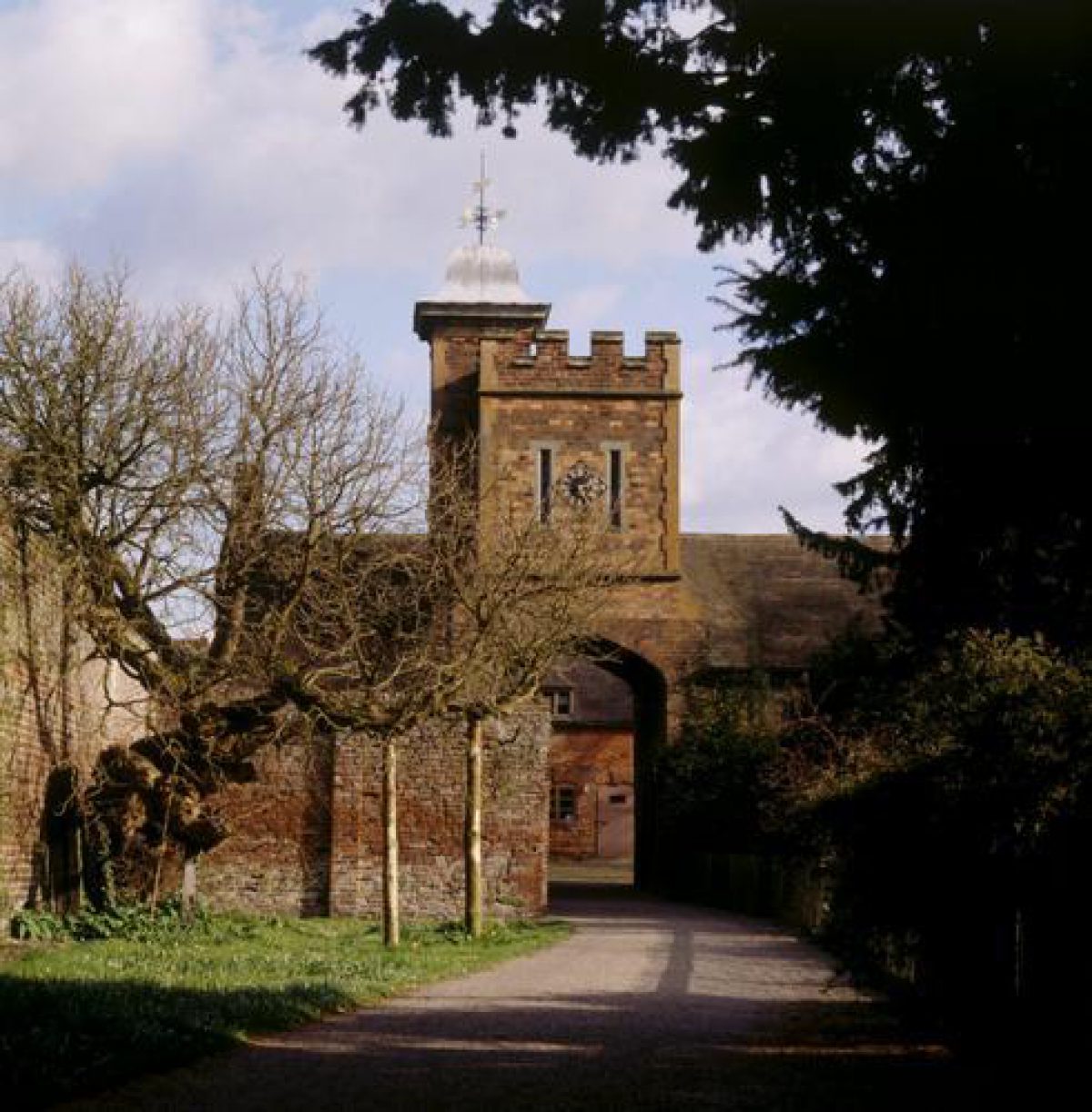
A farm and stables court of 1789 and the early C19 stands to the south-east, against the south-west side of the walled garden. Rising above its entrance is a crenellated brick tower of early to mid C19 date.
GARDENS AND PLEASURE GROUNDS
Before the north-east, entrance front is a turning circle, separated from the open parkland beyond by railings.
The main gardens and pleasure grounds lie on the other side of the Hall, dropping down to Big Pool, with the parkland rising up on its far side. Along the south-west, garden front of the Hall is a small terrace created in the 1920s. Below this the ground drops in two deeply scarped grass terraces, descended via a central flight of stone stairs. These features were created by William Wolryche-Whitmore soon after he succeeded his father in 1816; before that, as C18 illustrations show (Angus 1787; Copperplate Mag 1792), the ground fell to Big Pool in a smooth slope. At the north end of the terraces is a formal rockery, with four terraces retained by drystone walls. A path leads north from this, cut back into a low, red sandstone cliff. Again, these features are of the early C19.
The lawn and terraces south-west of the Hall are now without planting (some formal beds were filled in by Lady Labouchere). In contrast, the ground to the north, and especially the south, is well planted with specimen trees and shrubs. The former include several mature cedars of Lebanon, perhaps part of the late C18 planting (see below). The main shrubbery lies south of the terraces, within the remains of a ha-ha (now surmounted with a fence) constructed in the early C19 by William Wolryche-Whitmore. Here, in what he called his American Border, he planted numerous American hybrid rhododendrons. Although many of these have since been lost, planting continued after his death in 1858 and the area now contains a wide variety of specimens including magnolias, azaleas and Japanese cherries. The ha-ha runs to the south-east corner of Big Pool, and here there are small rockery pools, said to be an C18 Ladies' Bath. The Pool edge is planted as a water garden, created in the early C20.
A gate above the rockery pools gives access to a path which runs along the grassy slopes along the south side of the main part of Big Pool, allowing views up it and to the Hall. It then turns south, along the Pool side, passing a substantial Broseley brick boathouse of c 1865 with two gothic-arched entrances to the water. The path, here broad and terraced into the hillside, then runs south for c 200m, with wooded ground rising steeply to its east and a line of lime trees along its west edge. There are views through these trees across the Pool and to the parkland rising beyond. At the south end of Big Pool is a massive earth dam; from this, again, there are good views up the Pool. The path continues east of the remains of Mill Pool before swinging east into the wooded Dingle. Although much denuded and in parts overgrown, the walk up the north side of The Dingle still contains features likely to have formed part of the late C18 landscaping, including artfully placed groups of rocks, seats in the exposed red sandstone cliffs, pools, cascades, and specimen trees. The main walk emerges from The Dingle south of the Hall, a path leading across a short slope of parkland to a gate in the centre of the south side of the pleasure grounds.
In 1777 William Whitmore commissioned William Emes (d 1803) to produce a plan 'of the intended sheep pasture' (CL 1979, 818), that is the park around the Hall and enlarged ponds to its south-east. In the event a slightly different scheme was carried out, not by Emes but by the Dudmaston gardener Walter Wood. He, according to Whitmore's wife Frances (d 1792), 'whom we called Planter, had imbibed his taste at Shenstone's Leasowes (qv) ... the Badger (qv) and Dudmaston Dingles were long picturesque rivals'. The Dingles became one of Dudmaston's main attractions, and here Whitmore's wife, a good botanist and with access to the household's copy of Shenstone's Unconnected Thoughts on Gardening (1764), 'laid out the walks, placed seats and formed cascades' in conjunction with Wood (guidebook 1980, 19). Angus, writing c 1787, mentions The Dingle and its cascades and walks, 'which terminate in a beautiful prospect of the River Severn and the adjacent country'. A C19 watercolour at Dudmaston depicts a root house; its location is unknown.
Some changes were made to the pools and Dingle in the mid C19. The Tithe map of 1840 shows that at that date the south end of Big Pool (already enlarged by incorporating one or more smaller pools, for instance in 1818-19) was close to the present boathouse, and that south of it, extending to the north end of Mill Pool, was Summerhouse Pool. In the 1850s the dam between Big and Summerhouse Pools was removed, and probably that at the end of Summerhouse enlarged, to create the present, much larger, Big Pool.
PARK
There does not seem to have been a park at Dudmaston until William Whitmore began his improvements in the later 1770s. East of the Hall, extending to the A442, the parkland is level. Here there are many parkland and specimen trees of different ages. North, south and west of the Hall the parkland slopes down towards Big Pool, and is again well planted with parkland and specimen trees. East of the A422 the registered area extends to include Brim, Seggy and Wall Pools, and Comer (in 1840 'Commer or Cwm Mawr') Wood which surrounds them.
Lodge Farm (listed grade II) stands on the high ground along the west edge of the park, in an area where there are some of the oldest trees at Dudmaston, notably oaks and sweet chestnuts. Of two storeys and an attic, the house is of painted brick with stone dressings and was built in 1776. Its various external features, notably three crow-stepped gables, make the house an eyecatcher from the Hall.
KITCHEN GARDEN
The main compartment of the walled garden, still under cultivation, lies south-east of the Hall, its north-west wall forming one side of the service court. The walls are of brick, are buttressed, and likely to be of about the same date as the Hall. There is a late C20 orangery-like summerhouse in the centre of the north-east side of the garden with a small pool to its right (south-east) side. Against the south-east, inner wall of the compartment are some brick sheds, mostly C19, including a boiler house. This previously served glasshouses in a second walled garden, larger and its walls later than the first, which it abuts to the south-east. Although the walls of this second compartment largely survive, the glasshouses have all been removed and the interior is used by the National Trust for visitor parking.
REFERENCES Used by English Heritage
W Angus, Seats of the nobility and gentry in Great Britain and Wales ... (1787), plate 7
Copperplate Magazine I, (1792), plate 18
Country Life, 165 (8 March 1979), pp 634-7; (15 March 1979), pp 714-17; (22 March 1979), pp 818-21
Dudmaston, guidebook, (National Trust 1980)
G Jackson-Stops, An English Arcadia 1600-1900 (1992), pp 104-6
P A Stamper, Historic Parks and Gardens of Shropshire (1996), pp 55-6, 83
Maps
J Rocque, Map of Shropshire, 1752
William Emes, A Plan of the Intended Sheep Pasture, etc., at Dudmaston ..., 1777 (at Dudmaston Hall)
R Baugh, Map of Shropshire, 1808
Map of Dudmaston, 1817 (4001/P/1/5), (Shropshire Records and Research Centre)
C and J Greenwood, Map of Shropshire, 1827
Tithe map for Quatt, 1840 (Shropshire Records and Research Centre)
OS 6" to 1 mile: 1st edition surveyed 1882, published 1892; 2nd edition surveyed 1901, published 1903; 3rd edition published 1928
OS 25" to 1 mile: 1st edition surveyed 1882, published 1882
- Visitor Access, Directions & Contacts
Telephone
441746780866Access contact details
- History
The following is from the Register of Parks and Gardens of Special Historic Interest. For the most up-to-date Register entry, please visit the The National Heritage List for England (NHLE):
www.historicengland.org.uk/lis...
HISTORIC DEVELOPMENT
In 1403 Margaret de Butailles, the heiress of the family which had held the manor of Dudmaston since at least the early 12th century, married William Wolryche of Much Wenlock. The estate descended in that family, and in 1695 Sir Thomas Wolryche (died 1701) commissioned Francis Smith of Warwick to begin the present house. His son, Sir John, drowned in the River Severn in 1723, and Dudmaston passed in due course to his sister Mary (died 1771). From her it passed to her uncle Col Thomas Weld (died 1774), and from him to a distant Cousin, George Whitmore. He died, childless, in 1775, leaving as heir his nephew William Whitmore (died 1815). In 1775 the estate was apparently much in need of the improvement and investment detailed in an account book (Country Life 1979, 818). After this initial expenditure Whitmore turned to the Hall's surrounds, and in 1777 commissioned William Emes to produce a design for the park. Under his son William Wolryche Whitmore, Whig politician and MP, who in 1810 married Lucy, daughter of the Earl of Bradford, the Hall was altered in the 1820s and later large sums were spent on many of the farm buildings on the estate. On his death in 1858 there were outstanding mortgages on the estate of £60,000, not paid off until about 1900. His heir was his nephew Francis Henry Laing, who took the name Wolryche-Whitmore. From 1921 the estate was owned by his great-nephew Geoffrey Wolryche-Whitmore, under whom Dudmaston gained an international reputation for enlightened forestry. In 1952 he passed the estate over to his niece Lady Rachel Labouchere (died 1996) with the intention that it should eventually pass to the National Trust. That gift was completed in 1978.
Period
18th Century (1701 to 1800)
- Associated People
- Features & Designations
Designations
The National Heritage List for England: Register of Parks and Gardens
- Reference: GD2124
- Grade: II
Features
- Lake
- Description: Several small pools of the 18th century were amalgamated into Big Pool, which lies west of the hall.
- Earliest Date:
- Latest Date:
- Gate
- Description: The Eternity Gates were commissioned by Sir George and Lady Labouchere for their ruby wedding anniversary.
- Earliest Date:
- Latest Date:
- Rockery
- Description: A rockery, created around red sandstone outcrops to the north-west of the hall, was part of Geoffrey Wolryche-Whitmore's redesiging of the gardens in the 20th century.
- Earliest Date:
- Latest Date:
- Patio
- Country House (featured building)
- Description: Dudmaston Hall was first constructed by Francis Smith of Warwick in 1695. It was termed 'lately rebuilt' in 1730, and major alterations were carried out in 1826. The house is of red brick, and is nine bays with a five-bay recessed centre. There are stone quoins and window frames, and a large entrance hall with panelled walls. The attic was altered early in 1826, and features Grecian motifs.
- Earliest Date:
- Latest Date:
- Gate Lodge
- Description: There were two lodges of the early 19th century, called the North and South Lodges, lying north and east of the hall.
- Earliest Date:
- Latest Date:
- Garden Terrace
- Description: The grass slope west of the hall was terraced with steps leading down to the pool.
- Earliest Date:
- Latest Date:
- Key Information
Type
Park
Purpose
Ornamental
Principal Building
Domestic / Residential
Period
18th Century (1701 to 1800)
Survival
Extant
Hectares
185
Open to the public
Yes
Civil Parish
Quatt Malvern
- References
References
- {English Heritage Register of Parks and Gardens of Special Historic Interest}, (Swindon: English Heritage, 2008) [on CD-ROM] Historic England Register of Parks and Gardens of Special Historic Interest
- Newman, J. and Pevsner, N. {The Buildings of England: Shropshire}, (London: Yale University Press, 2006) The Buildings of England: Shropshire
- Stamper, P. A., {Historic Parks and Gardens of Shropshire} (Shrewsbury: Shropshire Books, 1996), pp. 55-6, 83 Historic Parks and Gardens of Shropshire
- {List of Historic Buildings: Bridgnorth Rural District}, (Bridgnorth: Bridgnorth District Council, 1974): 207. List of Historic Buildings: Bridgnorth Rural District