
Introduction
Alnwick Castle has landscaped pleasure grounds and a landscape park.
Terrain
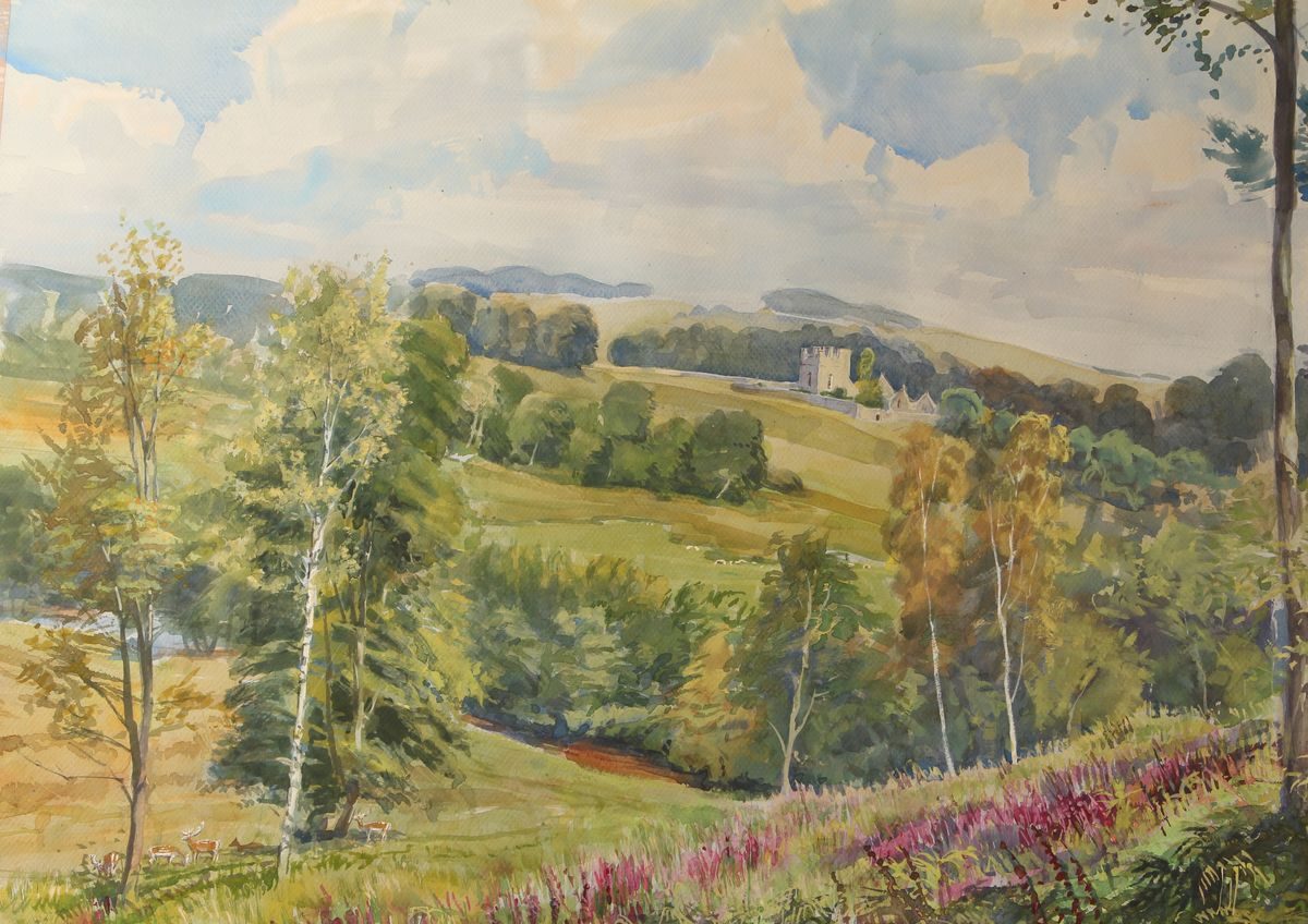
The land is a mixture of contrasting landscape types, with high heather moorland and the rough crags of the Northumbrian Sandstone Hills sweeping down to the improved pasture lands along the wooded Aln valley.
The following is from the Register of Parks and Gardens of Special Historic Interest. For the most up-to-date Register entry, please visit The National Heritage List for England (NHLE):
Extensive landscape parks and pleasure grounds developed from a series of medieval deer parks, around Alnwick Castle, the seat of the Percy family since the C14.
Location, Area, Boundaries, Landform and Setting
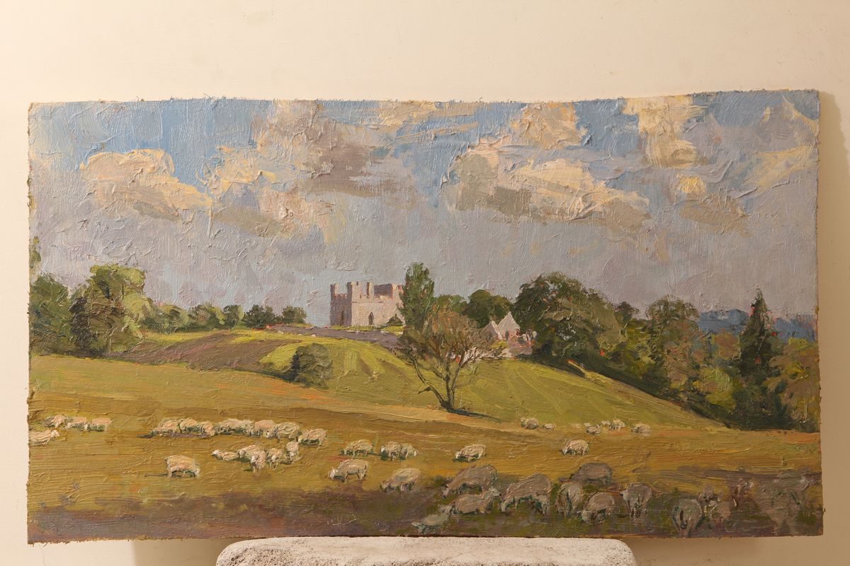
Alnwick Castle parks cover a tract of countryside encircling Alnwick town on its west, north, north-east, and south sides. The land is a mixture of contrasting landscape types, with high heather moorland and the rough crags of the Northumbrian Sandstone Hills sweeping down to the improved pasture lands along the wooded Aln valley. The parks exploit the boundaries of these distinctive landforms where the rugged moorland gives way to the pastoral, rolling landscape of the Aln, on its route to the sea. In the west parklands the river is confined between hills, and in places has incised deep, narrow valleys while in the east the landscape is more open.
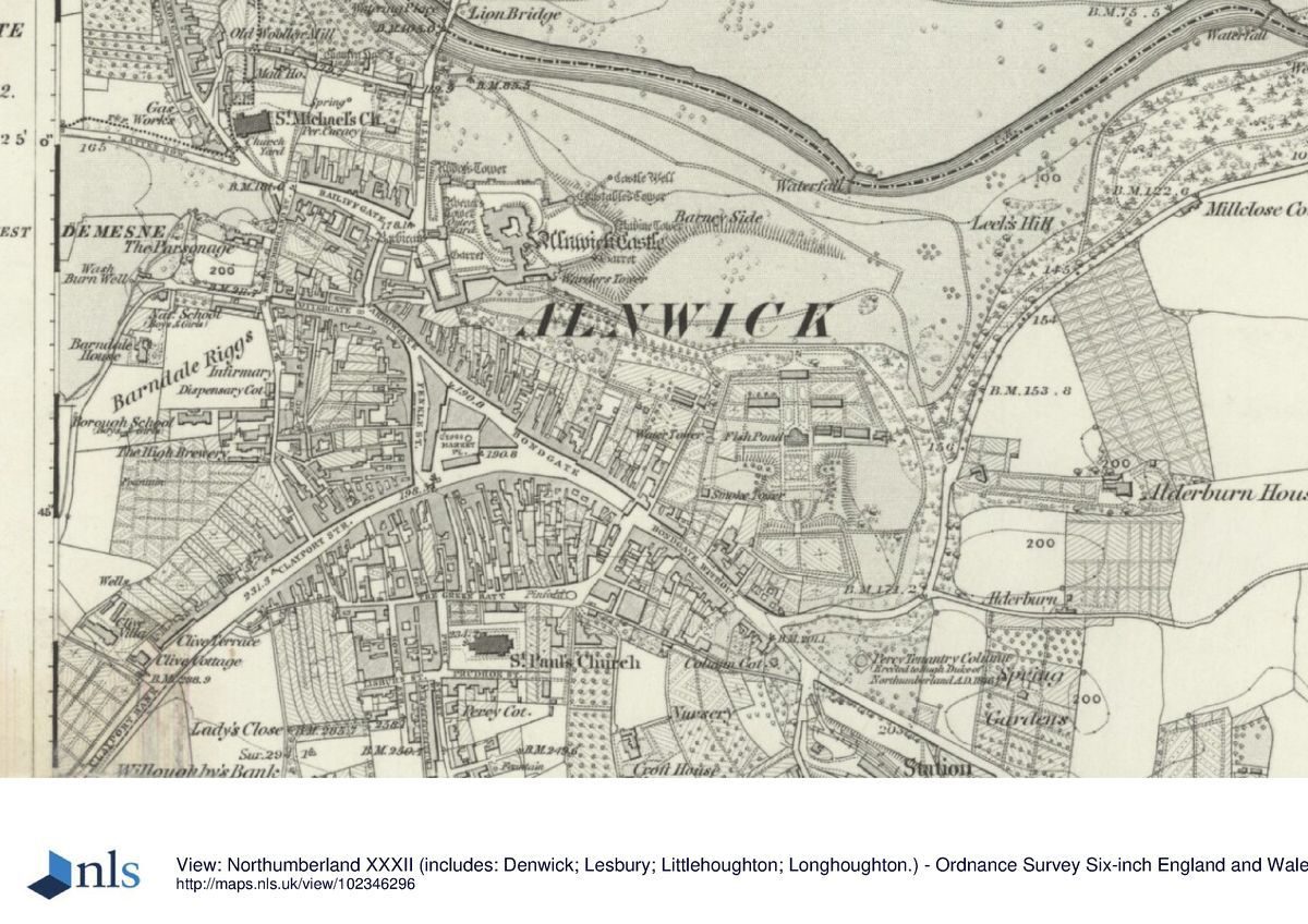
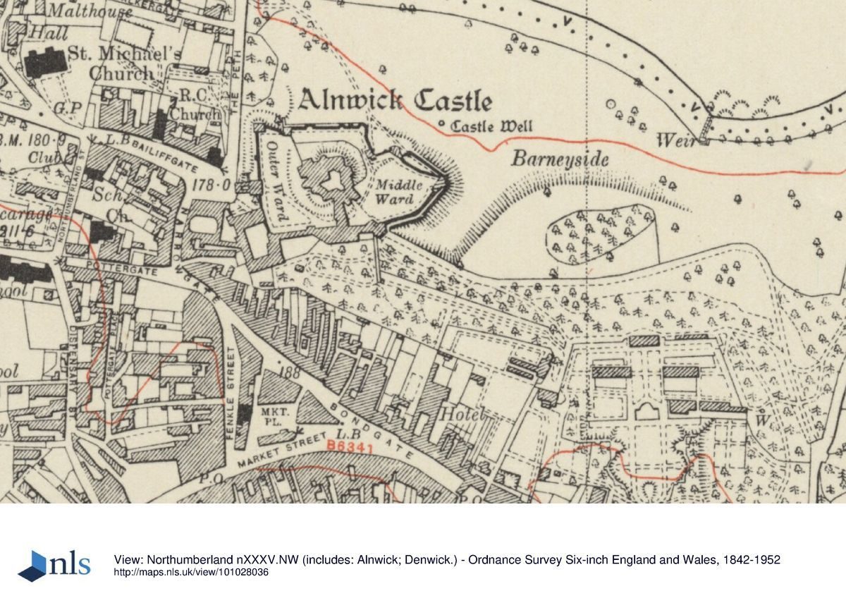
The registered area of 1300 ha is bounded on its north-east side by the Hulne Park wall, west of the Bewick to Alnwick Road (B6346). The west side of the area here registered follows field boundaries to the west of Shipley Burn, starting at Shipley Bridge, and then turns south-west at a point c 1km south of the bridge. It then runs for south-west for c 2.3 km, to the west of Hulne Park, before crossing the River Aln and running parallel to Moorlaw Dean for c 1.2 km, on the west side of the burn. The southern area is defined by Hulne Park wall running around the south point of Brizlee Wood then in a line due east, south of Cloudy Crags drive, to cross the Stocking Burn and reach Forest Lodge. The boundary then defines the north-western extent of Alnwick town and, crossing the Canongate Bridge, the southernmost extent of the Dairy Grounds.
To the east of the Castle the registered area takes in the entire North Demesne bounded on its north by Long Plantation, a perimeter belt which lies on the south side of Smiley Lane and then extends eastwards to meet the junction of the B1340 and A1 trunk road. The A1 has effectively cut through the North Demesne from north to south and, although physically divorcing the two areas, they are still visually conjoined. Defined on its north side within the hamlet of Denwick by tree belts, the park extends eastwards for 1km before cutting across southwards to meet the River Aln at Lough House. This latter stretch is bounded by a perimeter belt. The south boundary of the North Demesne follows the river in part, before meeting the Alnwick to Denwick road (B1340). To the south, the Castle gardens are delimited from the town by property boundaries along Bondgate. An outlying area of designed landscape at Ratcheugh is also included.
Entrances and Approaches
A complex series of drives is laid throughout the parks, particularly in Hulne Park. A series of thirty standing stones stand at the beginning of the drives or where they converge. These are inscribed with the names of the drives and act as signposts.
Principal Building
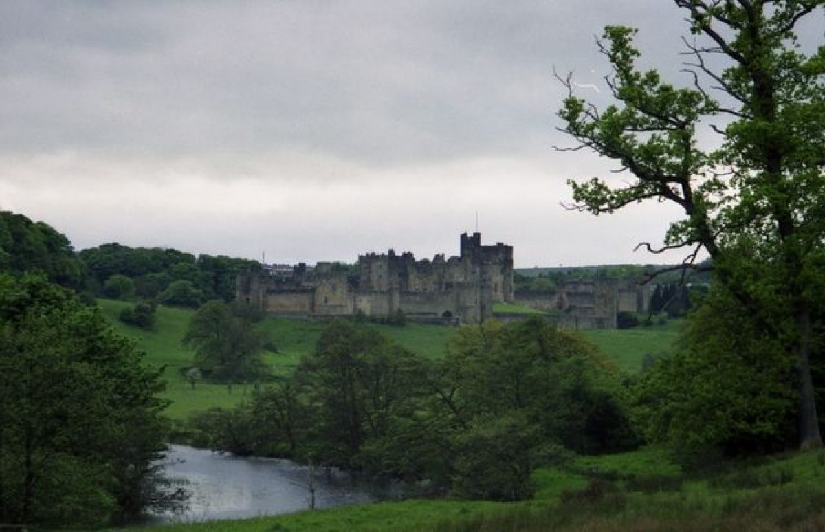
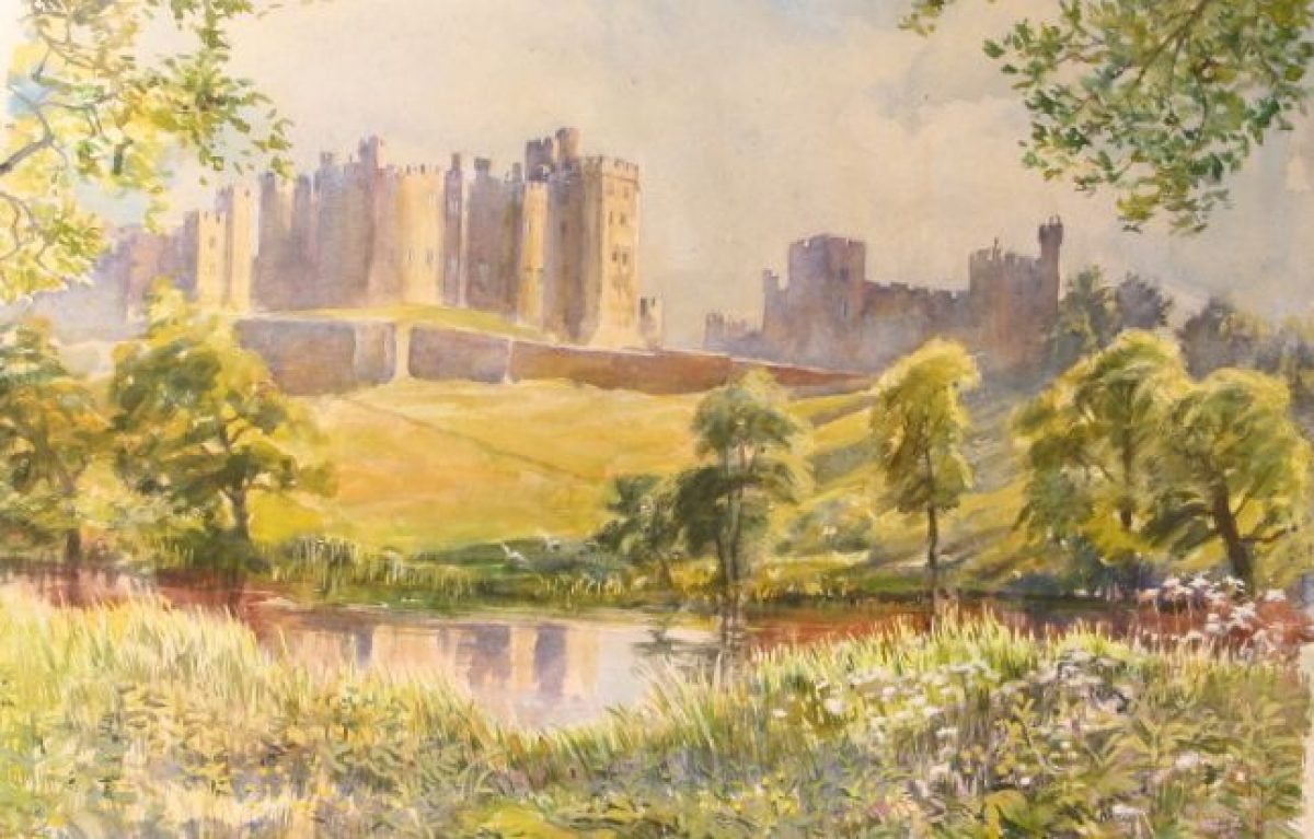
Alnwick Castle (1134 onwards, c 1750-68 by James Paine and Robert Adam, 1854-6 by Anthony Salvin, listed grade I) lies on the high ground on the south side of the Aln valley, commanding views to the north, east, and west. To the south is Alnwick town but the landscape is designed so that the town is not in view of the Castle. The principal views from the Castle lie over the North Demesne.
Walled Garden
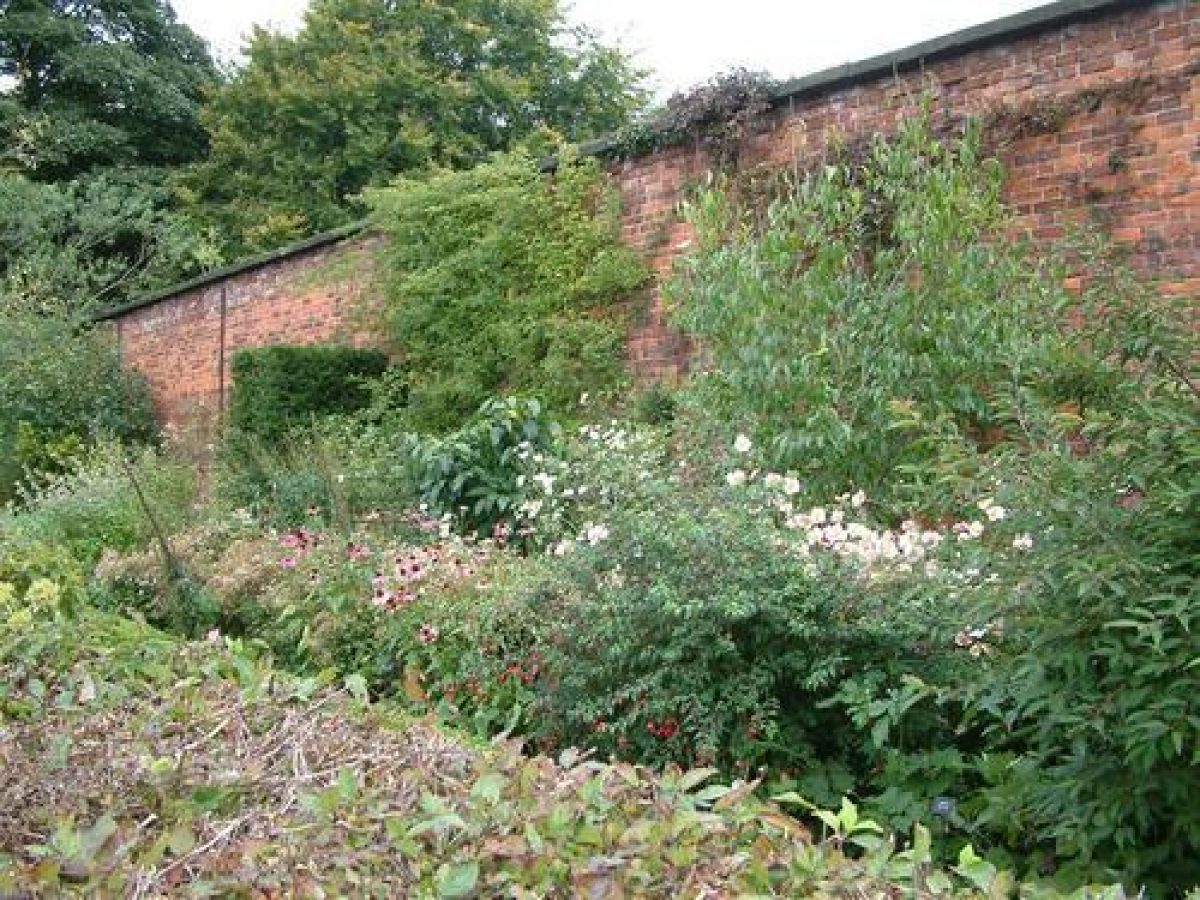
The walled garden of 3 ha lies to the south-east of the Castle, reached by the remains of C19 pleasure gardens laid out on the slopes above Barneyside. After the Second World War use of the glasshouses ceased, and until recently (late 1990s) the Estate Forestry Department used it. The earthwork terraces and remnants of specimen planting of Nesfield's scheme survive.
Park
The North Demesne originally included Denwick Park (they have now been divided by the A1 road), and together these 265 ha form the core parkland designed by Brown. Perimeter tree belts define the park, and clumps and scatters of specimen trees ornament the ground plan. The Aln has been dammed to give the appearance of an extensive, natural serpentine lake, with bridges as focal points: the Lion Bridge (John Adam 1773, listed grade I) and Denwick Bridge (1766, probably also by Adam, listed grade I). A programme of replanting and restoration of the North Demesne is under way (late 1990s).
The medieval deer park of Hulne extended to the north of the Shipley Road (outside the area here registered). Hulne Park is now 1020 ha and is in agricultural and forestry use. The principal entrance from Alnwick town is Forest Lodge, the only extant part of Alnwick Abbey. Hulne Park is completely enclosed by an early C19 perimeter wall, c 3m high with shaped stone coping and buttresses every 20m. Nearly 5 km of wall lies alongside roads, 5km across fields, and 5km defines perimeter woodland and moorland from the enclosed park.
The park design consists of a series of oval-shaped enclosures, defined by tree belts vital for shelter. The highest point is in the west area of the park, from where there are long-distance views east to the sea. The River Aln winds its way through the park via a series of contrasting steep valleys and flatter lands. The valleys are emphasised by planting on the upper slopes, while the lower areas are encircled with designed plantations to emphasise the river's meanders and ox-bow lakes.
Picturesque incidents survive at Nine Year Aud Hole, where the statue of a hermit (late C18, listed grade II) stands at the entrance to a natural cave along Cave Drive, and at Long Stone, a monolith standing high on the west side of Brizlee Hill, with panoramic views over Hulne Park to the north-west. The picturesque highlight is Hulne Priory (original medieval buildings, C18 alterations and enhancements, all listed grade I), which includes a summerhouse designed by Robert Adam (1778-80, listed grade I) and statues of praying friars erected in the Chapter House (late C18). The Priory's picturesque qualities are well appreciated from Brizlee Tower (Robert Adam, listed grade I), built in 1781 to commemorate the creation of the Alnwick parks by the first Duke and Duchess, a Latin inscription stating:
Circumspice! Ego omnia ista sum dimensus; Mei sunt ordines, Mea descriptio Multae etiam istarum arborum Mea manu sunt satae. [Look about you. I have measured all these things; they are my orders; it is my planning; many of these trees have been planted by my own hand.]
Brizlee is sited on a high point which can be seen in views north-west from the Castle, mirroring views north-east to the 'Observatory' on Ratcheugh Crag, a sham ruined castle sited as an eyecatcher on high ground and built by John Bell of Durham in 1784 (plans to further elaborate it were designed by Robert Adam).
Another principal feature of Hulne Park is a series of regular, walled enclosures (the walls set in ditches with banks cast up inside the compounds) which line Farm Drive, the central road through the park, north-westwards from Moor Lodge. This functioned as the third Duke's menagerie, and is still pasture.
The 15 ha Dairy Ground links Hulne Park and the North Demesne. It principally consists of the Aln valley north-west of the Castle, stretching between Canongate Bridge and Lion Bridge, laid out as pleasure gardens. Barbara's Bank and the Dark Walk are plantations laid out with walks on the steep slopes with a Curling Pond to the north of the Aln.
Description written: August 2000
Resgister Inspector: KC
Edited: June 2003
- Visitor Access, Directions & Contacts
Telephone
01665 511 100Website
https://www.alnwickcastle.com/Access contact details
For detailed visitor information visit the Alnwick Castle website.
- History
The following is from the Register of Parks and Gardens of Special Historic Interest. For the most up-to-date Register entry, please visit The National Heritage List for England (NHLE):
Historical Summary
Between 1750 and 1786, a picturesque landscape park was developed for Hugh, first Duke of Northumberland, involving work by James Paine, Robert Adam, and the supervision of work by Lancelot Brown (1716-83) and his foremen Cornelius Griffin, Robson, and Biesley in the 1760-80s, working alongside James and Thomas Call, the Duke's gardeners. During the C19 each successive Duke contributed and elaborated on the expansive, planned estate landscape, within which the landscape park was extended. This was accompanied by extensive C19 garden works, including a walled, formal flower garden designed in the early C19 by John Hay (1758-1836), and remodelled mid C19 by William Andrews Nesfield (1793-1881).
Note: This entry is a summary. Because of the complexity of this site, the standard Register entry format would convey neither an adequate description nor a satisfactory account of the development of the landscape. The user is advised to consult the references given below for more detailed accounts. Many Listed Buildings exist within the site, not all of which have been here referred to. Descriptions of these are to be found in the List of Buildings of Special Architectural or Historic Interest produced by the Department of Culture, Media and Sport.
13th Century
In the C13, Hulne Park, West Park, and Cawledge were imparked within the Forest of Alnwick. Hulne Park lay to the north-west of Alnwick Castle and Cawledge to the south and south-east. By the late Middle Ages, Hulne Park extended to 4000 acres (c 1620ha) enclosed by some 13 miles (c 21km) of wall. It was stocked with some 1000 fallow deer and a tower at Hulne Priory served as a hunting lodge.
18th Century
The parks formed the basis of Alnwick Park, landscaped by Sir Hugh Smithson (1714-86) who in 1750 became Earl of Northumberland, inheriting his father-in-law's northern estates. Prior to this, from 1748 he and his wife, Elizabeth Seymour (1716-76), had lived at Stanwick, Yorkshire (qv) and at Syon Park, London (qv), where they had already established a reputation for gardening, attested by Philip Miller's dedication, in 1751, of his Gardener's Dictionary to the Earl.
Together they embarked on an ambitious scheme to restore the Castle, develop the grounds and estate, and restore the Percy family traditions and identity at Alnwick. Those employed at Alnwick were also involved elsewhere on the Northumberland estates: James Paine, architect at Syon House, Daniel Garrett, architect at Northumberland House, the Strand (1750-3), Robert Adam, architect at Syon (1762-9), Lancelot Brown, landscape architect at Syon Park (1754-72).
In 1751, Thomas Call (1717-82), who had been the Earl's gardener at Stanwick, prepared a scheme for the parklands and pleasure grounds, including a plan for Brizlee Hill (the south part of Hulne Park). Call and his relation James, working at Alnwick by 1756, were responsible for the development of Hulne Park over twenty years. The date and extent of Lancelot Brown's involvement at Alnwick is uncertain, although his foremen Griffin, Robson, and Biesley worked at Alnwick with teams of men between 1771and 1781 and records shown that they also worked alongside Call and his men (in 1773 for example, Call had a team of sixty men and Biesley one of seventy-eight).
Hulne Park was developed as a picturesque pleasure ground with extensive rides, follies, and the enhancement of natural features. A characteristic of the Duke's scheme was his recognition of antiquarian sites within the landscape, which were embellished. Thus in 1755, Hulne Priory was purchased to become the focal point of Hulne Park. A garden was made within the cloister walls and, from c 1763, the priory became the gamekeeper's residence, with a menagerie of gold and silver pheasants. Statues of friars cut by the mason Matthew Mills were set in the landscape. In 1774, a medieval commemorative cross to Malcolm Canmore (listed grade II), situated at the northern entrance to the North Demesne, was restored.
Following the Duchess' death in 1776, the Duke decorated all her favourite locations with buildings, some being ideas she had noted in her memoranda. Work also included other notes and ideas the Duchess had had, including the ruin at Ratcheugh Crag and some ninety-eight drives and incidents.
Plans for the parklands at the North Demesne, Denwick, and Ratcheugh Crags were developed in the late 1760s, although in the case of the North Demesne some parkland planting had been undertaken by 1760, and the major work undertaken in the early 1770s is that attributed to Brown, mainly on stylistic grounds.
19th Century
During the C19, under the second Duke (1742-1817) the parks were extended, this including the purchase of Alnwick Abbey and part of its estate. The complex of drives was also extended and this was accompanied by extensive plantations, including the large Bunker Hill plantation central to the north area of Hulne Park, named to commemorate the Duke's action in 1775 in the War of American Independence. Most significantly, between 1806 and 1811, building centred on construction of a perimeter wall, defining the boundary of Hulne Park, and lodges and gateways at entrances to the parks. The carriage drives were extended, necessitating the construction of bridges over the River Aln. These schemes were implemented by estate workers, local masons, and David Stephenson, the Duke's architect.
As the Castle had no formal flower gardens, John Hay was commissioned between 1808 and 1812 to design pleasure gardens to the south-east of the Castle, linking it with a new walled garden at Barneyside, furnished with a range of hothouses, glasshouses, and pine pits. These were extended in the 1860s when Anthony Salvin, employed in the restoration of the Castle, built a gateway between the inner bailey and the pleasure gardens. Nesfield designed a scheme for the walled gardens to be developed as an ornamental flower and fruit garden, with a large central pool, conservatory, and a series of broad terraces and parterres. The Alnwick scheme can be compared to Nesfield's in the precincts of Arundel Castle, West Sussex (qv), in 1845.
20th Century
Alnwick Castle, parks and estate remain (2000) in private ownership, the latest significant developments being the replanting and restoration of the North Demesne (1990s) and plans to completely remodel the walled garden.
- Associated People
- Features & Designations
Designations
The National Heritage List for England: Register of Parks and Gardens
- Reference: GD2043
- Grade: I
Features
- Castle (featured building)
- Description: Alnwick Castle lies on the high ground on the south side of the Aln valley,
- Lake
- Description: The river Aln has been dammed to give the appearance of an extensive, natural serpentine lake, with bridges as focal points:
- Deer Park
- Description: The medieval deer park of Hulne
- Statue
- Description: Statue of a hermit (late C18, listed grade II) at Nine Year Aud Hole,
- Walled Garden
- Description: A walled garden of 3ha lies to the south-east of the Castle, reached by the remains of C19 pleasure gardens laid out on the slopes above Barneyside.
- Natural Landscape
- Description: Contrasting landscape types, with high heather moorland and the rough crags of the Northumbrian Sandstone Hills sweeping down to the improved pasture lands along the wooded Aln valley.
- Priory
- Description: Hulne Priory (original medieval buildings, C18 alterations and enhancements, all listed grade I)
- Formal garden
- Description: The Castle gardens are delimited from the town by property boundaries along Bondgate. An outlying area of designed landscape at Ratcheugh is also included.
- Summerhouse
- Description: Summerhouse designed by Robert Adam (1778-80, listed grade I)
- Statue
- Description: Statues of praying friars erected in the Chapter House (late C18).
- Tower
- Description: Brizlee Tower (Robert Adam, listed grade I),
- Plantation
- Description: Plantations ( Barbara's Bank and the Dark Walk) the steep slopes with a Curling Pond.
- Pleasure Garden
- Description: Hulne Park includes a 15ha Dairy Ground link between Canongate Bridge and Lion Bridge, laid out as pleasure gardens.
- Sham Ruin
- Description: The 'Observatory' on Ratcheugh Crag, is a sham ruined castle sited as an eyecatcher on high ground and built by John Bell of Durham in 1784
- Key Information
Type
Park
Purpose
Ornamental
Principal Building
Domestic / Residential
Survival
Part: standing remains
Hectares
1288
Open to the public
Yes
Civil Parish
Alnwick
- References
References
- {English Heritage Register of Parks and Gardens of Special Historic Interest}, (Swindon: English Heritage, 2008) [on CD-ROM] Historic England Register of Parks and Gardens of Special Historic Interest
- Stroud, D., {Capability Brown} (London: Faber, 1975), pp. 103-4 Capability Brown
- Land Use Consultants {Restoration Management Plan, Alnwick Castle} (1996) Restoration Management Plan, Alnwick Castle
- Northumberland County Council Armstrong's Map of Northumberland, Alnwick Plan 1769
- pp 523-4, 587; ii (1902), pp 273-4 Gardeners' Chronicle II
- pp 100-1, 188; 20 (1881), pp 155-6, (Holding institution is the Library of Congress, USA) The Garden, 5
- Published by Johnson G W and Hogg R., pp 296-8 The Journal of horticulture, cottage gardener and country gentlemen
- Finch P., Republished by Legare Street Press (2023) History of Burley on the Hill
- Country Life, 65
- pp 174-7 Garden History 9
- Tyne & Wear County Council Museums (1983), pp 19, 22-3, 27, 42 Capability Brown and the Northern Landscape
- Alnwick Castle, guidebook
- Related Documents
-
CLS 1/320
Restoration Mangement Plan - Digital copy
LUC - 1996
-
CLS 1/320