Introduction
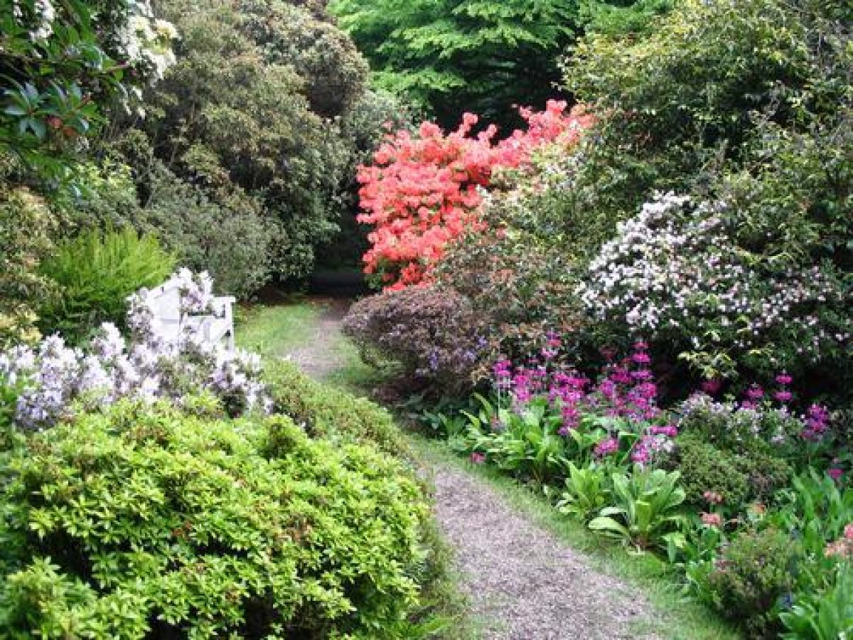
Howick has an early-20th-century woodland garden set within 35 acres of 19th-century wooded pleasure grounds and a 50-hectare late-18th-century parkland.
Terrain
Howick Hall is set on a plateau at the top of the valley.The following is from the Register of Parks and Gardens of Special Historic Interest. For the most up-to-date Register entry, please visit The National Heritage List for England (NHLE):
Late 18th-century parkland and early 19th-century wooded pleasure grounds, developed from 1917 onwards into an extensive woodland garden.
Location, Area, Boundaries, Landform and Setting
Howick Hall lies 7km to the north-east of Alnwick and 1.5km inland, west of Howick village. The open landscape of the North Northumbrian Coastal Plain has been modified by the extensive tree planting on the Howick estate, which lies on both banks of the Howick Burn. The Burn forms a steep-sided valley running from north-west to south-east across the estate before issuing into the sea, 500m south of Howick Haven.
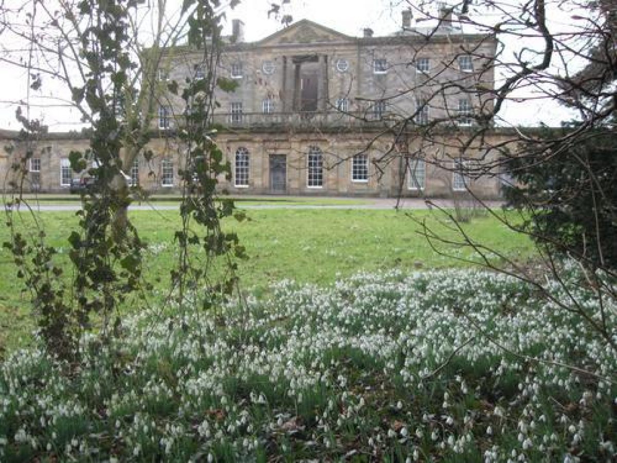
Howick Hall is set on a plateau at the top of the valley. From the south front there are views, across the valley and the Howick Burn, to the parkland which rises up beyond to the horizon. The main vista southwards from the Hall is set within a framework of trees, formed by the wooded pleasure grounds.
Entrances and Approaches
The main entrance to Howick Hall lies at the East Lodge, to the south-west of Howick village, 150m north-east of the Hall. The entrance lies through ornamental gate piers with a single-storey lodge to the north. The drive leads through a shrubbery and curves gently round southwards to the main, north entrance of Howick Hall.
An entrance courtyard is enclosed by the east and west wings of the Hall, and the main, south block of the Hall. It is set with a turning circle. From the East Lodge, the road leads directly eastwards, outside the area here registered, to Howick Haven, 1.5km south-east of the Hall and the site of the Boat House (now demolished), built to receive goods for the Hall carried by sea. The West Lodge, standing 800m directly west of the Hall, lies on the B1339 and marks a secondary route to the Hall, leading through Damses Wood.
Principal Building
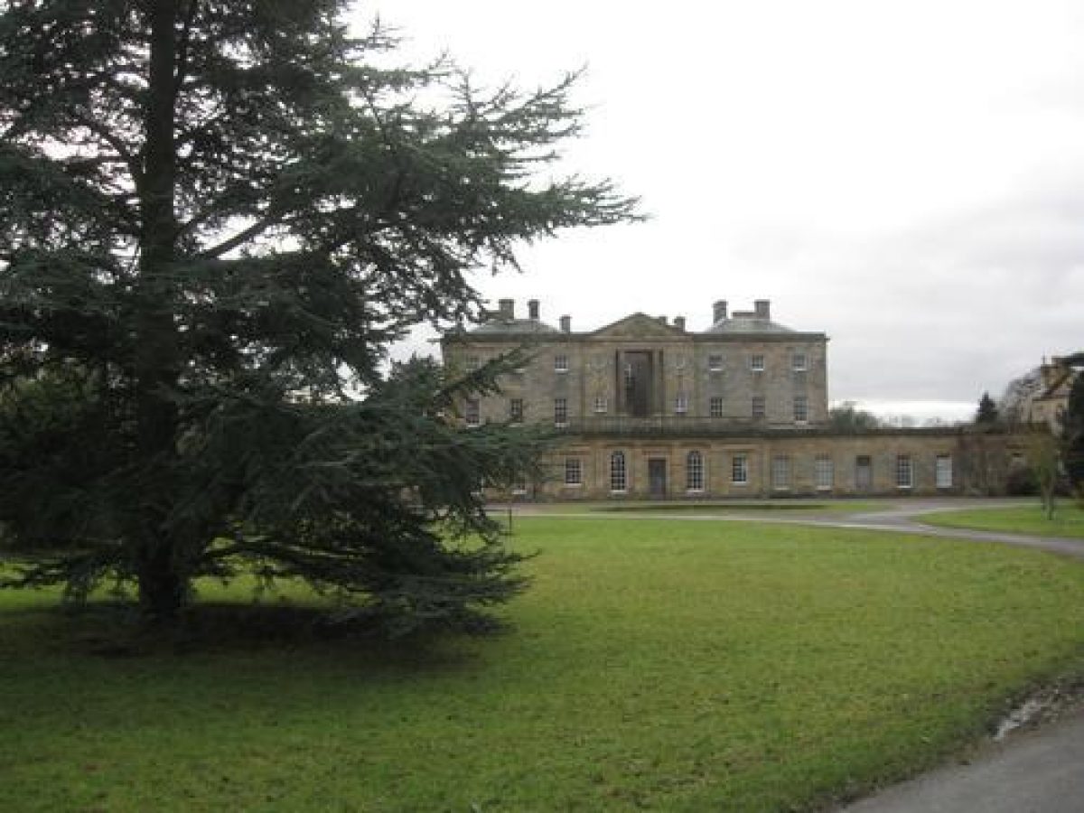
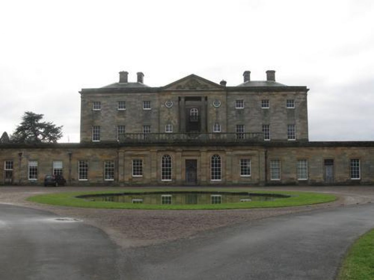
Howick Hall (listed grade II*) was designed by William Newton in 1782, for Sir Henry Grey, with a south, entrance front of nine bays and a pedimented three-bay centre. In 1809 George Wyatt was commissioned to build an Entrance Hall, in Tuscan style, on the north front. Following a fire which gutted much of the house in 1928, it was remodelled by Baker and Scott.
The west wing (Newton 1782, listed grade II*) comprises the former kitchen wing, now a private residence, and service buildings, while the east wing forms the stableyard buildings (Newton 1782, listed grade II*). Both have formal elevations onto the entrance courtyard.
Gardens and Pleasure Grounds
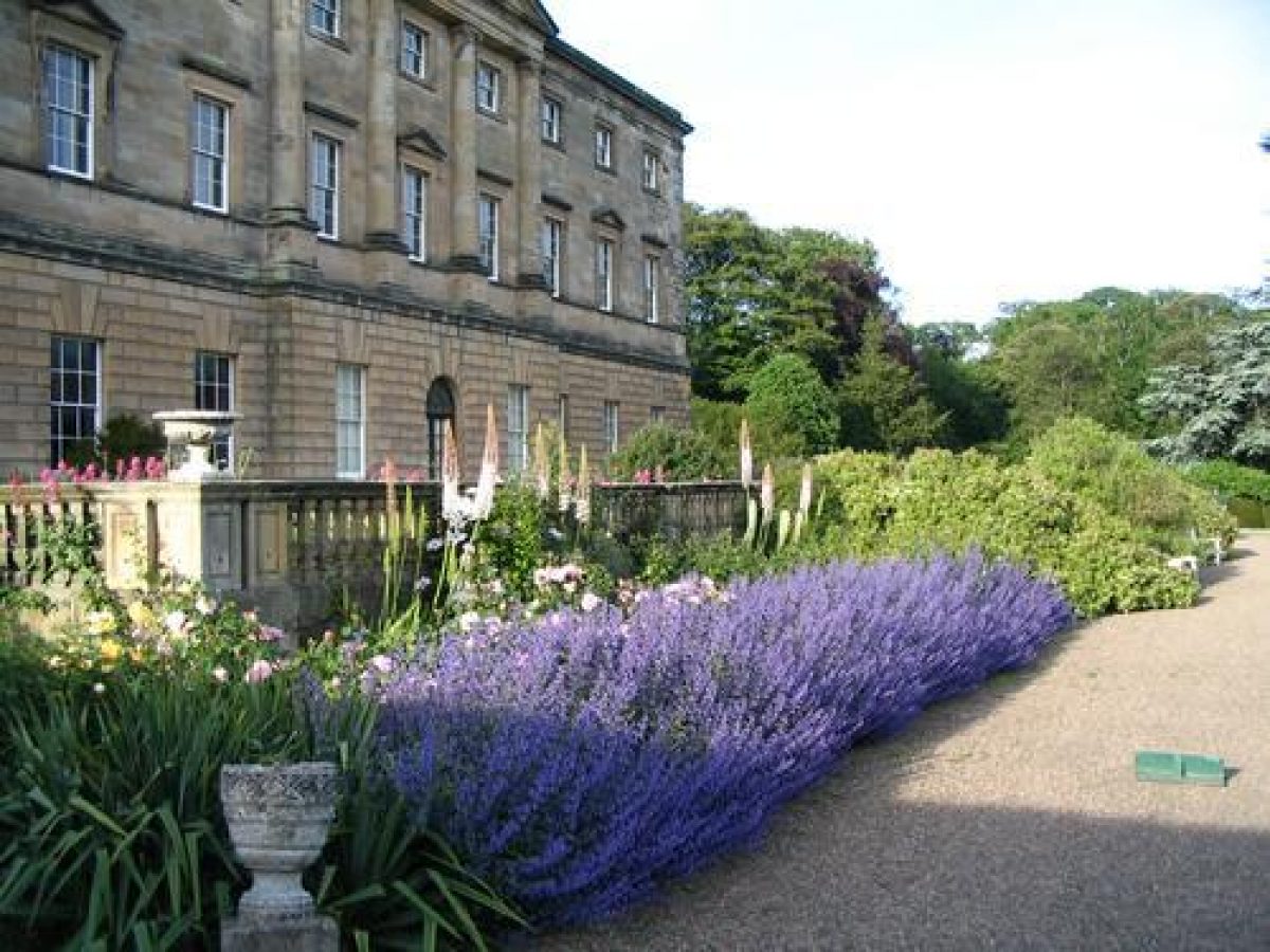
The gardens lie to the south of the Hall, where a balustraded upper terrace (Wyatt 1809, listed grade II) is set against the south facade. This rectangular terrace terminates at its east and west ends with flights of moulded steps and, on the south side of the terrace, a central flight of steps lead down to a middle terrace.
The middle terrace (terrace wall 1-1.5m high, Wyatt 1809, listed grade II) widens out into a rectangular platform set with a circular fountain (early C20) and yew-hedged enclosures. From the fountain a path descends to a lower terrace and then to the Howick Burn, which bounds the lawns to the south.
Two footbridges cross the Howick Burn. To the east of the Hall, in Greenseat Wood is the woodland garden of c 1.5 ha, planted from 1930 onwards, also known as the Silver Wood. It contains many plants from Asian expeditions of the 1920s and 30s, and from notable British collections, all set within the shelter of the beech and oak woodland.
Kitchen Garden
A trapezoidal walled garden (listed grade II) of some 2 ha lies 100m to the north-west of the west wing. The late C18 walls are faced in brick with a stone coping. On the south side of the walled garden is a terraced lawn running the length of the south wall, enclosed by a ha-ha. The ha-ha wall, c 1 m in height, has a stone coping.
Park
The park of c 50ha lies to the west, south, and south-east of the Hall. The Howick Burn set in a steep, wooded valley to the south of the Hall flows from west to south-east across the park. In the C19 the wooded, northern bank carried an ornamental carriage drive through Cushat Wood. This partly survives as a hardcore track commencing on the east side of the 'dry' bridge (early C19, listed grade II), 320 m south-east of Howick Hall. The Burn issues into the sea some 1.6km south-east of the Hall, at the south-east tip of Cushat Wood.
The western parkland is enclosed by Damses Wood on its north side, and along its eastern and southern boundaries by tree belts. The road to Howick village leading off from the B1339 passes from south-west to north-east through the park, separating this west park from a smaller area of land to the east. It crosses Howick Burn by way of a road bridge (early C19, listed grade II), 320m south-east of Howick Hall, which is in turn crossed at a higher level by the aforementioned 'dry' bridge. The eastern area is bounded on its north and east by Cushat Wood, adjacent to the Howick Burn, and by Crow Wood to the south. A further area of woodland extends towards Howick village, to the north of the east park. This lies outside the area here registered. All three areas are currently (2003) being developed as an arboretum.
The parish church, rebuilt in 1849 after a fire to designs by F J Francis, is set 100 m south-east of the Hall. It lies amongst trees and within a walled churchyard, reached from the gardens across a tooled stone bridge with ashlar dressings (late C18 or early C19, both listed grade II), on the south bank of the Howick Burn. The church tower appears in a vista from the Hall, and is reached by a small path leading across a bridge from the gardens. Beyond, to the south, is open parkland set with scattered trees and clumps.
Maps
OS 6" to 1 mile: 1st edition surveyed 1860, published 1865; 2nd edition surveyed 1896
Description written: January 2001
Amended: March 2003
- Visitor Access, Directions & Contacts
Access contact details
The gardens are open daily between March and October. Please see: http://www.howickhallgardens.org/openingtimesandadmission.php
Directions
The site is off the A1 north of Alnwick, through Longhoughton and on the B1339. Please see: http://www.howickhallgardens.org/directions.php
Owners
Charles, 2nd Lord Howick of Glendale and family
Howick, NE66 3LB
- History
The following is from the Register of Parks and Gardens of Special Historic Interest. For the most up-to-date Register entry, please visit The National Heritage List for England (NHLE):
The Grey family have owned and lived at Howick since the 12th century. Sir Henry Grey, who became High Sheriff of Northumberland in 1736, built 'a large house and elegant offices' to the north of 'the old tower of Howick, mentioned by Leyland' (Wallis 1769). This tower probably lay in the vicinity of the village, clustered around the parish church to the south-east of the Hall. Sir Henry also laid out a shrubbery and plantation to the west of the house, and built a 'new bridge of ashler-work' over the Howick Burn (Wallis 1769).
This house was demolished and a new one built, in 1782, for Sir Henry's son and heir, Sir Henry Grey Baronet, MP for Northumberland, from designs by William Newton (1730-98) of Newcastle (see entry on Hesleyside, Wallington). The entrance front of the new house lay on the south. Charles, 2nd Earl Grey, who inherited the estate in 1807, commissioned George Wyatt (1782-1856) in about 1809 to undertake extensive internal alterations to the house and to change the entrance front to the north. His scheme included landscape works, namely new entrance gates, as well as: 'the approached altered, and the lawn broken in a better style. Howick Burn, a fine trout-stream skirts the lawn, and is crossed by a neat stone bridge, of fine ashlar-work. The brook, following its course from the west, between grass-lawns, shaded by a plantation, makes its exit by a gentle fall. A beautiful fish-pond abounds with fine trout and perch, and the surface is enlivened by the majestic motions of two beautiful swans.' (Mackenzie 1825)
By canalising Howick Burn, a wide, crescent-shaped lawn to the south of the Hall was delimited, in a similar style to that at Hesleyside (see description of this site elsewhere in the Register). The gardens, to the south of the Hall, consisted of a single terrace with lawns, sloping down to the Burn, set with specimen trees.
The parish church was rebuilt to appear as an Ionic temple within the park and the village was removed to the present site of Howick village in about 1850 (Lord Howick personal communication, 2001).
During the late 19th century a lower terrace was built, and set with parterres of low box hedges. A major phase of planting started in 1917 when Lord and Lady Grey developed a woodland garden within the existing 19th-century wooded pleasure grounds. A rhododendron garden, with many newly introduced species rhododendrons, was planted on the greensand from 1930 onwards.
Early introductions of trees and shrubs were obtained directly from Wakehurst, East Sussex and Westonbirt, Gloucestershire through family connections, and from a wide circle of gardening friends including Caerhays, Cornwall (see descriptions of Wakehurst, Westonbirt and Caerhays elsewhere in the Register). A series of bulb collections and herbaceous borders were developed to the south of the terraced gardens. This horticultural family tradition has been continued through the establishment of an extensive arboretum in the east park which extends through Cushat Wood, Crow Wood, and fields to the east and north of the Hall (1990s onwards). The site remains (2000) in private ownership.
Period
- 20th Century (1901 to 2000)
- Early 20th Century (1901 to 1932)
- Associated People
- Features & Designations
Designations
The National Heritage List for England: Register of Parks and Gardens
- Reference: GD2050
- Grade: II
Features
- Tree Feature
- Description: Arboretum
- Herbaceous Border
- Rockery
- House (featured building)
- Description: The house was built by William Newton and altered by George Wyatt in 1809. Much of the interior was destroyed by fire in 1926 and parts were re-built on a different plan.
- Earliest Date:
- Latest Date:
- Gardens
- Description: The gardens with balustraded upper terrace (Wyatt 1809, listed grade II) set against the south facade
- Parkland
- Description: Park of c 50ha
- Church
- Description: Parish church, rebuilt in 1849
- Kitchen Garden, Ha-ha, Walled Garden
- Description: A trapezoidal walled garden (listed grade II) of some 2ha lies
- Lodge
- Description: East and West Lodges
- Woodland garden
- Key Information
Type
Garden
Purpose
Recreational/sport
Principal Building
Domestic / Residential
Period
20th Century (1901 to 2000)
Survival
Extant
Hectares
87
Open to the public
Yes
Civil Parish
Longhoughton
- References
References
- White, S., {Gardens of Northumberland and the Borders} (Cramlington: Sanderson Books Limited, 2006), pp. 96-101 Gardens of Northumberland and the Borders
- {English Heritage Register of Parks and Gardens of Special Historic Interest}, (Swindon: English Heritage, 2008) [on CD-ROM] Historic England Register of Parks and Gardens of Special Historic Interest
- Pevsner, N., J. Grundy and I. Richmond, {The Buildings of England: Northumberland} (London: Penguin, 1992) The Buildings of England: Northumberland
- 26 January 1884, p 112 Gardeners' Chronicle II
- (1957, reprinted 1974), pp 194-5 The Buildings of England: Northumberland