Introduction
Acton Burnell has the remains of a fortified manor house which is in the care of English Heritage. There is also a deer park which was later developed as a landscape park. Other features include a walled garden, two artificial lakes and a grotto.
The following is from the Register of Parks and Gardens of Special Historic Interest. For the most up-to-date Register entry, please visit the The National Heritage List for England (NHLE):
www.historicengland.org.uk/lis...
Medieval deer park developed as a landscape park associated with a country house in the 18th century.
DESCRIPTION
LOCATION, AREA, BOUNDARIES, LANDFORM, SETTING
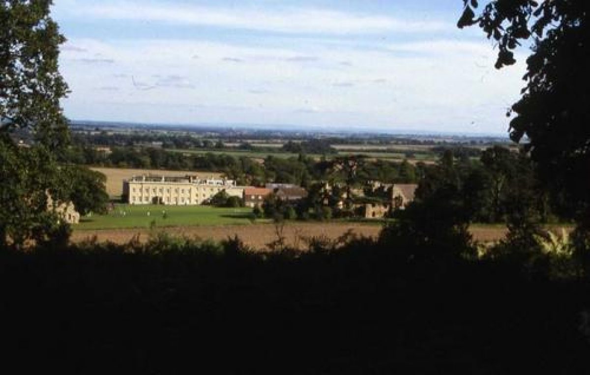
Acton Burnell Hall stands c 11km south-east of Shrewsbury, south and east of the village of Acton Burnell. The Hall stands on the southern edge of the Shrewsbury Plain, locally drained by the Coundmoor Brook and other tributaries which run to the River Severn c 5km to the east. Rising behind, south of, the Hall are the wooded slopes of Acton Burnell Hill. Panoramic views are obtained from this of Acton Burnell and the Shrewsbury Plain beyond, with The Wrekin, c 10km to the north-east, a prominent feature. To the west the park is partly bounded by the unclassified road from Acton Burnell to Ruckley, and to the north and north-east by that from Acton Burnell to Kenley. To the south the park boundary runs along the southern slope of the hill occupied by Park Wood, parallel with and above the minor road from Ruckley to Langley. The area here registered is c 230ha.
ENTRANCES AND APPROACHES
The main approach is from the west, along a short drive from Acton Burnell village. West Lodge (listed grade II), a timber-framed cottage of late C17 origins, stands on the south side of the main, early C19, gate piers. A gothic facade was removed from the Lodge in 1962.
A tree and shrub-lined drive leading east from the Hall and along the inside of the park wall to a gate east of Black Dick's Lake was no longer in use in the later C20. The planting along its length survived however.
PRINCIPAL BUILDING
It appears that it was Sir Richard Smythe who, c 1700, built the earlier part of the present Hall (listed grade II*), including a Roman Catholic chapel. That house was enlarged in 1753-8 by Sir Edward Smythe, who inherited in 1737, to designs by William Baker of Audlem. It was at that date that the Hall assumed its present seven-bay north and south facades, known to have been in existence by 1805. In 1814 the Catholic architect John Tasker created a giant tetrastyle Ionic portico on the Hall's north side, flanked by two bays between angle pilasters. The Hall was restored after 1914 when fire gutted the interior.
The Hall stands 100m north of its predecessor, Acton Burnell Castle (listed grade I), a fortified country house built in the 1280s for Robert Burnell. This itself stands immediately south-east of Acton Burnell church (listed grade I), rebuilt by Burnell at about the same time.
GARDENS AND PLEASURE GROUNDS
The Hall stands towards the north-west corner of a rectangular area of former pleasure grounds, 500m long from east to west and 200m wide. This area, largely lawn, contains many of the residential and other buildings built eastward of the Hall in the late C20 for Concord College. Also contained within this area, 100m south-east of the Hall, are the two stone gables of the Parliament Barn, traditionally the meeting place of the Parliament of 1283. From the later C18, if not before, these formed an antiquarian feature of the pleasure grounds, as did the Castle ruins which were added to in the later C18 to make them more scenic. Some specimen trees still survive in the area, notably a large cedar of Lebanon next to the Castle, while west of the Castle is an evergreen shrubbery. These plantings, originally incorporating a walk linking Hall and church, were probably part of the later C18 park improvements, and in 1891 Leach stated that the shrubbery walk and many of the trees at Acton Burnell were planted by the Benedictine monks whose Mission was established at the Hall in 1715.
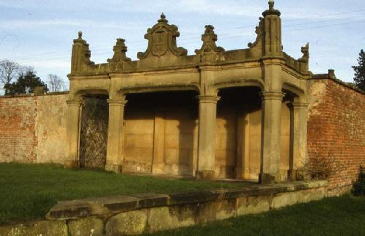
Before the Hall's north front is a car park with a narrow strip of grass beyond. East of this, at the end of the former drive from the east, is an area of specimen trees and shrubs. These screen the north side of a balustraded garden, 150m east of the Hall, built against the west end of the walled kitchen garden. This is now a lawn, with three mature Irish yews along its east side. In the late C19 it contained a glasshouse, presumably a conservatory.
PARK
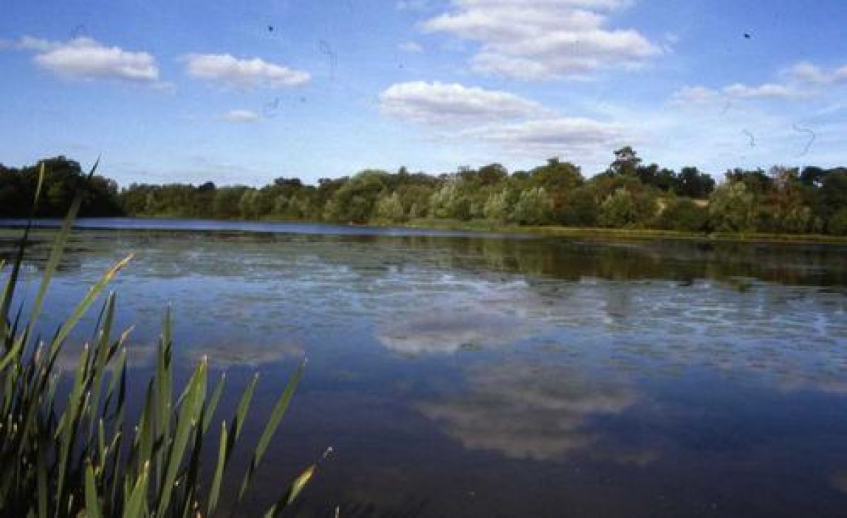
The park extends up from the level ground around the Hall, lakes and Sham Castle to take in the southern slopes and summit of Acton Burnell Hill. The level ground is almost all used as arable farmland; only a very few parkland trees, including coniferous specimen trees, survive. There is a small area of permanent pasture east of Black Dick's Lake, and several grass fields on the western edge of the park, running up onto the Hill. Shadwell Lake and Black Dick's Lake were managed in 1998 for fishing. They may have been enlarged, perhaps in the late C18, from the fishponds first mentioned in the late C13. Both are retained by dams along their east ends. Standing on a rocky knoll on the laund east of Acton Burnell Hill, 150m south of Black Dick's Lake, is Sham Castle (listed grade II, also known as Black Dick's Tower and as Park Cottage), a gothick lodge or prospect tower of 1778-80 designed by Samuel Scoltock (d 1819). Triangular and with circular corner towers, the two-storey lodge was restored from a ruinous state in the 1980s. Swiss Cottage, mapped in the late C19 at the west end of Shadwell Lake and presumably looking along it, was represented in the 1990s by brick footings in scrubby woodland. The complete absence of walling or roofing materials suggests that its upper part was of wood and thatch. Set in the hillside 100m south of Shadwell Lake is an icehouse (listed grade II), probably of the later C18 or early C19. No trace could be found in 1998 of a bath house marked on the Tithe map of 1845. This lay c 250m south-west of the south-east corner of Shadwell Lake, probably at the head of a small stream valley.
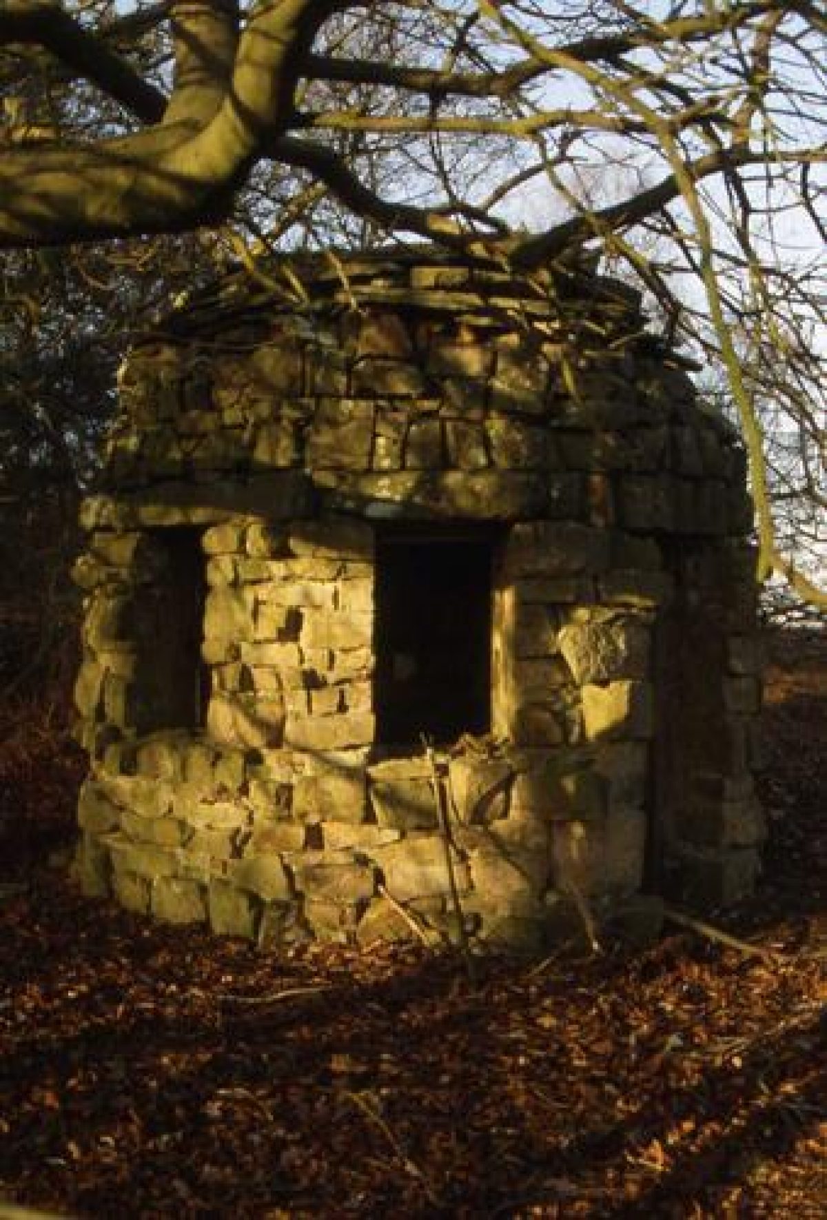
Acton Burnell Hill is indented with various folds and valleys, which presumably gave the name ('Cumbes', ie combe, valley on flank of hill: see below) used for its covering woodland in the C13. Gardener's Pool lies in one such fold. The main access from the Hall was apparently at the west end of Shadwell Lake, and here as a track climbs the Hill there are several mature coniferous specimen trees. Today the Hill is almost wholly wooded. In some parts the woodland is coniferous plantation, but mostly the woodland is very open, with mature and veteran oaks, and some beech, chestnut and silver birch, all standing in dense bracken. There are some open launds, and a network of tracks in part following the lines of earlier walks and drives. The Shell House, a grotto-like summerhouse (listed grade II) of 1779-80 stands off one such walk, on the northern crest of Acton Burnell Hill, 550m south of the Hall and overlooking it, its grounds and the Shrewsbury Plain beyond. It is built of boulder-like sandstone, with a corbelled roof of flatter stones, and externally has a cell or igloo-like appearance. Inside the ceiling is covered with elaborate and good quality shellwork; beneath are vestiges of glazed tiles which once covered the walls. Missing in 1996 were the window frames, door case, internal bench and central table.
Long stretches of the south-west and north-east boundaries of the park are defined by stone walls, 1-2m high, and similar walls also occur as internal boundaries within the Hill woods, for instance at the north end of Shadwell Coppice. These walls seem likely to be of the late C18 or early C19, when the present park boundaries were fixed (see below).
There has probably been a park centred on Acton Burnell Hill since 1270 when Robert Burnell was given licence to inclose 40 acres (c 16ha) of Cumbes Wood, to which a further 60 acres (25ha) were added in 1280. By 1292 there were deer leaps and fishponds. Within a century the pale had been replaced by a wall, at least on the south side. In 1752 the park was largely wooded and extended south to the Kenley to Church Preen road, with its western boundary east of Langley Hall. A small common to the east of the Ruckley road, near Hollies Coppice, was inclosed and added to the park c 1759. Late C18 improvements including Sham Castle, the grotto, the lakes and the incorporation of the Castle as a scenic ruin, suggest an ambitious programme of landscaping. Another possible addition to the park at this time was a model of the Iron Bridge (no longer extant), purchased c 1782 by Sir Edward Smythe from the brother of its designer T F Pritchard. Drawings of the park published in 1803, although very difficult to interpret, show the lakeside then to have been very open, and suggest that there may have been more buildings in the park than described above. By 1805 the park contained 248 acres (c 103ha). About 1815, at about the time that the Ionic portico was added to the north front of the Hall, Sir Edward Smythe moved the Acton Pigott road north from the Hall to its present line and created a drive from Pitchford (no longer extant) which ran under the new road. At about the same time the southern boundary of the park was probably pulled in to its present line. Since then there have been no significant alterations to the park's bounds.
KITCHEN GARDEN
Various lengths of C18 brick walls belonging to the kitchen gardens survive c 200m east of the Hall, incorporated within College buildings of the later C20. The east, end wall of the main compartment is stone. At its north end is the brick facade of a mid C18 summerhouse. Largely late C20 accommodation now lies along the back of the stone wall. The interior of the former gardens is lawn with some fruit trees. East of the main walled compartments is a frame yard with some C19 and early C20 pits, a greenhouse and sheds.
REFERENCES
F Leach, The County Seats of Salop (1891)
The Victoria History of the County of Shropshire viii, (1968), pp 3-13
P A Stamper, Historic Parks and Gardens of Shropshire (1996), pp 45-6, 49
M G Harvey, Regi Semper Fidelis: A Study of the Smythe Family of Acton Burnell, Shropshire, 1750-1850, (unpublished MA dissertation, Univ of Keele 1997) [copy in Shropshire Records and Research Centre]
Maps
J Rocque, Map of Shropshire, 1752
R Baugh, Map of Shropshire, 1808 C and J Greenwood, Map of Shropshire, 1827
Tithe map for Acton Burnell, 1845 (Shropshire Records and Research Centre)
OS 6" to 1 mile:
1st edition surveyed 1881, published 1888
2nd edition surveyed 1901, published 1903
OS 25" to 1 mile: 1st edition surveyed 1882, published 1882
Illustrations
Two lithographic views of Acton Burnell Park, 1803 [photographic copies in SRRC, neg nos B5214-15]
Archival items
The Smythe Collection is held at the Shropshire Records and Research Centre.
Description written: November 1998
Register Inspector: PAS
Edited: February 2000
- Visitor Access, Directions & Contacts
Access contact details
The site is open daily and is free to visit.
Directions
There is a free car parking area very close to the entrance of the site for approximately 5 cars.
Located in Acton Burnell, signposted from A49, 8 miles S of Shrewsbury
Owners
English Heritage
- History
Robert Burnell, later bishop of Bath and Wells and Chancellor of England, was lord of the manor by 1269. In 1270 Burnell imparked 70 acres (28 hectares) from 'Cumbes wood', to which 60 acres (24 hectares) was added in 1280. By 1290 the park had three deer leaps and Burnell had been granted the right of free warren. The park was walled, at least to the south, by 1379.
The park survived into the post medieval period. John Rocque's map of Shropshire from about 1752 shows that the park was largely wooded. It extended south to the Kealey-Chruch Preen road and its western boundary lay east of Langley Hall. Between 1750 and 1799 various garden features were added to the park including the grotto, the gate lodge and the Sham Castle.
By 1808 Robert Baugh's map of Shropshire shows that the park had been reduced in size by about half (Trinder: 1983). Its new southern boundary was that of the 1888 Ordnance Survey map. To the north it had geen extended up to the Acton Burnell-Acton Pigott road. It is believed that this extension to the north followed the rebuilding of Acton Burnell hall shortly before 1805.
In the late 19th century the park was about 280 acres (112 hectares) and had 180 fallow deer. Timber included oak, chestnut, yew birch and elm (Whitaker: 1982, 126).
The following is from the Register of Parks and Gardens of Special Historic Interest. For the most up-to-date Register entry, please visit the The National Heritage List for England (NHLE):
www.historicengland.org.uk/lis...
HISTORIC DEVELOPMENT
In the Middle Ages Acton Burnell belonged to the Burnells, one of whom, Robert Burnell (died 1292), Bishop of Bath and Wells and Lord Chancellor, rose to national prominence in the late 13th century. In the 1270s and 1280s he rebuilt the church and manor house in an advanced architectural style and created a deer park on the hill which rises behind them. The manor later passed to the Lovells, from whom it was forfeited to the Crown in 1485. In 1617 it was bought by Humphry Lee of Langley Hall, whose granddaughter, Mary, married Sir Edward Smythe of Eshe Hall (Durham); it was through her the Smythes acquired Acton Burnell. Smythe, a recusant who in 1660 was created a baronet, is known to have been living at Acton Burnell in 1662, although by 1672 he had removed to Langley. Thenceforward the Smythes were normally seated at Acton Burnell, the Hall being rebuilt in the 1750s by a subsequent Sir Edward (died 1784) who later, in the last years of his life, improved and embellished the landscape park. The Smythes sold the Hall, which became a school, in 1939, and much of the rest of the property in 1949. The park however was retained, and remains (1998) in private hands. In 1973 the Hall was sold to its owner in the late 1990s, Concord College.
Period
18th Century (1701 to 1800)
- Associated People
- Features & Designations
Designations
The National Heritage List for England: Register of Parks and Gardens
- Reference: GD2114
- Grade: II
Features
- Lake
- Description: Black Dick's lake was created during the mid- to late 18th century. It was probably created from an earlier fish pond relating to the medieval deer park.
- Earliest Date:
- Latest Date:
- Lake
- Description: Shadwell lake was created during the mid- to late 18th century. It was probably created from an earlier fish pond relating to the medieval deer park.
- Earliest Date:
- Latest Date:
- Grotto
- Description: The grotto or 'shell house' was created in about 1750. It is located about 550 metres south of the hall on the north west slopes of Acton Burnell hill.The grotto is octagonal in plan, employing rustic coursed and squared sandstone. It also has a domed roof. Inside are the remains of shell-work, chinese-type glazed picture tiles, a central table and wall bench.
- Earliest Date:
- Latest Date:
- Gate Lodge
- Description: The gate lodge or 'cottage' was re-modelled in the gothic style in about 1750.
- Earliest Date:
- Latest Date:
- Prospect Tower
- Description: The Sham Castle is triangular in plan with circular corner towers. It was built in the gothic style.
- Earliest Date:
- Latest Date:
- Icehouse
- Description: A brick icehouse south of Shadwell lake.
- Earliest Date:
- Latest Date:
- Planted Walk
- Description: Shrubberies were incorporated into a walk close to the hall. They are believed to have been planted in the mid to late-18th century(Leach: 1981, 219).
- Earliest Date:
- Latest Date:
- Hall (featured building)
- Description: The manor house was built on the site in the 1270s and 1280s. The hall was rebuilt in the 1750s.
- Earliest Date:
- Latest Date:
- Key Information
Type
Park
Purpose
Ornamental
Period
18th Century (1701 to 1800)
Survival
Part: standing remains
Hectares
230
Open to the public
Yes
Civil Parish
Acton Burnell
- References
References
- {English Heritage Register of Parks and Gardens of Special Historic Interest}, (Swindon: English Heritage, 2008) [on CD-ROM] Historic England Register of Parks and Gardens of Special Historic Interest
- Trinder, Barrie, {Robert Baugh's map of Shropshire: An Introduction} ([n.p.]: Shropshire Archaeological Society, 1983) Robert Baugh's map of Shropshire: An Introduction
- Whitaker, Joseph, {A Descriptive List Of The Deer Parks and Paddocks Of England} ([n.p.]: Ballantyne Hanson & Co, 1982) A Descriptive List Of The Deer Parks And Paddocks Of England
- Leach, F, {The County Seats of Shropshire} ([n.p.]: [n.pub.], 1891) The County Seats of Shropshire
- Stamper, P. A., {Historic Parks and Gardens of Shropshire} (Shrewsbury: Shropshire Books, 1996), pp. 45-6, 49 Historic Parks and Gardens of Shropshire
- Gaydon, A.T. {Victoria County History: Shropshire, Volume 8} (London: Constable, 1968), pp. 3-13 Victoria County History: Shropshire, Volume 8
- Related Documents
-
CLS 1/474
Masterplan (1st Draft) - Hard copy
Camilla Beresford for English Heritage - 1991
-
CLS 1/474