
Introduction
Ugbrooke Park is a mid-18th-century landscape park and woodland comprising 5 hectares of gardens and pleasure grounds, and about 200 hectares of parkland and woodland. There is also 30 hectares of pleasure grounds, parkland and woodland associated with Lawell House. Features include specimen trees, a series of lakes, a waterfall and an orangery.
Terrain
Ugbrooke Park lies in the upper valley of the Ugbrooke, a stream which flows from north-east to west-south-west through the park. The ground rises to high points to the north at Castle Dyke Camp, and to the south-west.The following is from the Register of Parks and Gardens of Special Historic Interest. For the most up-to-date Register entry, please visit The National Heritage List for England (NHLE):
An early C18 formal park landscape, remodelled in the mid and late C18 by Lancelot Brown, with C19 gardens and pleasure grounds around a mansion rebuilt by Robert Adam in the mid C18.
Location, Area, Boundaries, Landform and Setting
Ugbrooke Park is situated some 2km south-east of the town of Chudleigh, and c 2km north-east of the village of Ideford. The A380 road from Exeter to Newton Abbot passes through the site, running from north-east to south through the park c 550m south-east of the House. The c 235ha site comprises c 5ha of gardens and pleasure grounds, c 200ha of parkland and woodland and c 30ha of pleasure grounds, parkland and woodland associated with Lawell House which afford views of the picturesque Chudleigh Rocks. The site is bounded to the north and south-east by rubble-stone walls c 3m high which enclose the park. Elsewhere the site is enclosed by traditional hedge banks which adjoin agricultural land and minor roads to the south and south-west of the site. Ugbrooke Park lies in the upper valley of the Ugbrooke, a stream which flows from north-east to west-south-west through the park. The ground rises to high points to the north at Castle Dyke Camp, and to the south-west. To the north of the Gappah to Biddlecombe road which forms the northern boundary of the park, the land falls steeply through Riding Parks to Lawell House and Chudleigh Rocks, an area of quarried land with cliffs, caves and exposed rocks. The site has extensive views north and west towards Dartmoor.
Entrances and Approaches
Ugbrooke Park is approached from a minor road which runs north-west from Ideford to Biddlecombe through the site to the north-east of the park. The principal entrance is at Ashwell, some 400m east-north-east of the House. Ashwell Lodge (listed grade II), a mid C19, two-storey stone and thatch cottage stands opposite and to the north-east of the principal entrance, which comprises a pair of square-section stone piers surmounted by domed caps and lead heraldic wyverns, and a similar central stone pier. The piers, constructed in 1970, support a pair of wide, low, ornamental wrought-iron gates. The tarmac drive ascends south-west for c 180m, passing a group of late C20 ponds created from former withy beds immediately south of the entrance, and the stables (listed grade II) which were constructed to designs by Joseph Rowe in 1793 some 240m north-east of the House. Turning south-south-west for c 100m, the drive turns sharply south-south-east to reach a late C20 gravelled car park which lies to the east of the drive and which is separated from the park by a late C20 conifer hedge. The drive continues beyond the car park, sweeping south, south-south-west and north-west round the boundary of the gardens and pleasure grounds to approach the House from the south.
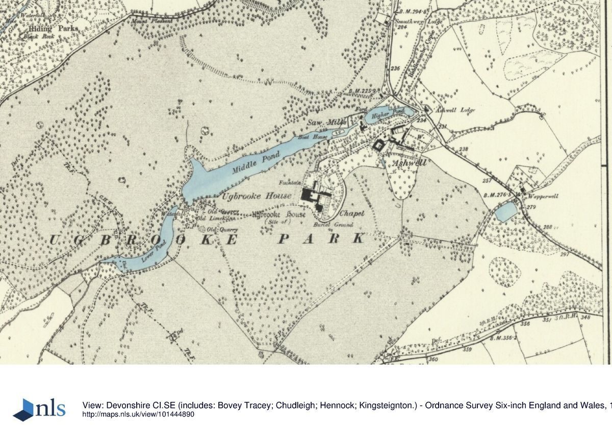
The gravelled carriage court east of the House is entered through a monumental round-headed arch. Some 200m north-east of the House a spur leads c 100m south-west from the principal drive before turning south for c 100m to approach the carriage court from the north. A further drive approaches the House from the A380 road to the south. A late C20 single-storey gabled lodge stands within the site to the south of a pair of late C20 square-section rusticated piers flanked by wing walls, which support arched wrought-iron gates ornamented with wyverns and armorial achievements. The south drive passes north-north-west across Colleyhole Park through a late C20 avenue of Leyland cypress and Norway maple to approach the House from the south-west. The late C20 avenue replaced an early C18 double avenue shown on an estate plan of 1740 by William Doidge. Doidge's Plan shows a further double avenue leading to an entrance set in a semicircular plantation adjacent to the Exeter road to the east-south-east of the House. This approach and avenue were partly removed by Lancelot Brown c 1780, although an entrance at Wapperwell remodelled in the late C18 and adjoined by C19 agricultural buildings survives c 480m south-east of the House. The present principal approach, the south drive and the south-east avenue formed part of the second Lord Clifford's early C18 park landscape.
A late C18 drive forming part of Lancelot Brown's scheme for Ugbrooke approaches the House from Chudleigh and Lawell House to the north-west, passing through the park. The north-east drive enters the park from the minor road from Ideford to Biddlecombe at Smoothway Lodge (listed grade II) at a point c 550m north-north-east of the House. Smoothway Lodge is an early C19 picturesque rustic cottage with a thatched, hipped roof, rustic verandah and gothic windows, standing in a cottage garden retained by a rubble-stone wall. The south-west drive enters the park from Gappah Lane which forms the south boundary of the registered site. Passing north through a plantation for c 260m, the south-west drive reaches Clapperland Lodge (listed grade II), an early or mid C19 cottage orné of stone construction with first-floor dormer windows set into the thatched roof. The lodge stands to the south-east of massive square-section stone gate piers which mark the entrance to the park.
Principal Building
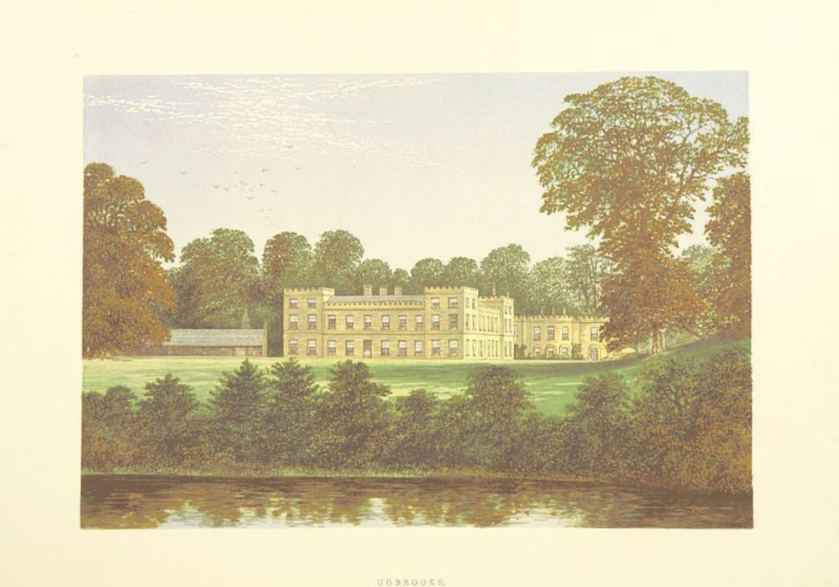
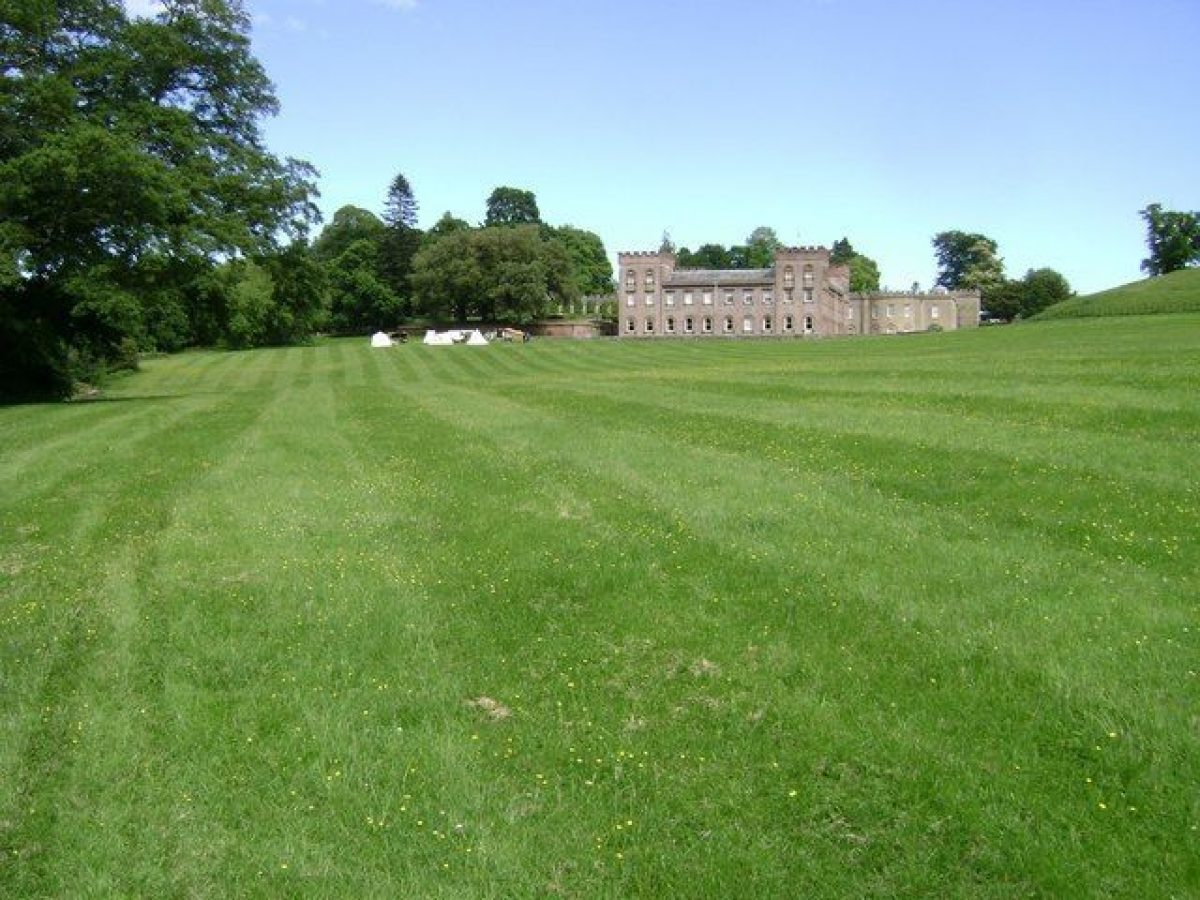
Ugbrooke Park (listed grade I) stands on a level terrace constructed on the north-west-facing slope above the Ugbrooke and overlooking the park. The House was reconstructed in its present form to designs by Robert Adam between 1763 and 1768, and is the earliest example of Adam's use of a castellated design for a country house (Cherry and Pevsner 1989). Adam's scheme was adopted in preference to others submitted by John Carr, James Paine and Lancelot Brown. Symmetrical on plan, the House is constructed around a courtyard with wings to the north, south and west. Service quarters to the east were demolished in the mid C20. A wing containing the library and chapel extends south from the south-east corner of the House; it was also remodelled by Adam in 1767-8, and has a shallow two-storey bow on the west facade and a battlemented parapet.
The main house has four square, battlemented corner turrets which rise to three storeys above the principal facades which are of two storeys. The rubble-stone walls were rendered to resemble ashlar in the mid C19, and other details were altered at the same period. A mid C19 conservatory extends east from the south wing above the south entrance to the courtyard to link the House to the chapel wing. The earlier house remodelled by Adam is shown on Doidge's Plan of 1740, and was a west-facing E-plan structure. Adam built a new west wing and reduced the western projection of the chapel or south wing. The chapel was consecrated as a private Anglican chapel for the first Lord Clifford in 1671, but was altered for Roman Catholic worship on his conversion in 1672. It became a parish church for Chudleigh in the mid C19 when the structure was extended and altered internally. Following a period of decline during and immediately after the Second World War, the House was the subject of a major restoration programme from 1957.
Gardens and Pleasure Grounds
The formal gardens lie to the north-west and east of the House, with areas of informal pleasure grounds to the north, east and south. To the west a simple grass terrace below the principal façade of the House is retained by a stone ha-ha, possibly of mid or late C19 construction (Pearson Assocs 1993), and allows wide views across the park and lakes to the west. This lawn replaced the bowling green shown to the west of the House by Doidge in 1740.
The mid or late C19 parterre at the north-west corner of the House is constructed on a level terrace retained to the west by a rubble-stone wall and grass bank. Geometric box-edged beds are arranged on a rectangular lawn, with a young (planted c 1995) monkey puzzle as the focal point. Shrub and herbaceous borders, mainly replanted in the late C20, surround the parterre lawn to the north and north-west, with further mixed planting on a bank to the east below a range of service buildings. The parterre terrace replaced an area shown as the 'Old Orchard' on Doidge's Plan (1740). Informal areas of lawns planted with trees and shrubs extend to the north and north-east of the House and east of the north drive.
Some 30m north-east of the House an early C19 orangery (listed grade II) constructed from stone and brick under a hipped, tiled roof with five tall round-headed windows on the south facade stands to the north of a formal garden which was probably laid out in its present form in the early C20 (OS 1906). An axial walk, partly lined by an avenue of Chusan palms, extends c 40m south from the orangery between large beds of lavender. Forming a terrace above a service drive to the east of the chapel, the orangery walk is terminated to the south by a pair of low stone piers. A flight of stone steps at the south-east corner of the orangery ascends a grass bank which encloses the orangery garden to the east, to reach a further area of informal lawns planted with ornamental trees and shrubs.
The gardens and pleasure grounds are separated from the drive to the east by an C18 ha-ha which is now (1999) a grassy depression, allowing the pleasure grounds to merge with further lawns adjoining the drive. To the south of the chapel and c 30m south-south-east of the House, the Chapel Garden is an area of lawn with evergreen shrubs and mature yew trees to the east adjacent to a low stone boundary wall surmounted by spear-headed wrought-iron railings. To the south the garden is enclosed by a C19 ashlar wall.
Park
The extensive park surrounds the House and gardens, and includes high ground to the north and south-west of the Ugbrooke valley, and areas to the east of the House which are now separated from the majority of the park by the late C20 A380 road from Exeter to Newton Abbot. Today (1999) the park from north-west to south-east of the House remains predominantly pasture with scattered trees and boundary plantations which broadly correspond to the disposition shown on a late C18 design attributed to Lancelot Brown (private collection). To the north and north-east of the House areas of the park are today (1999) broken, although C18 and C19 planting survives.
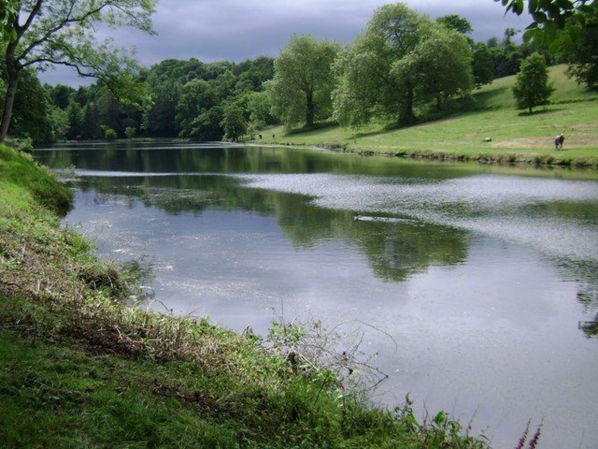
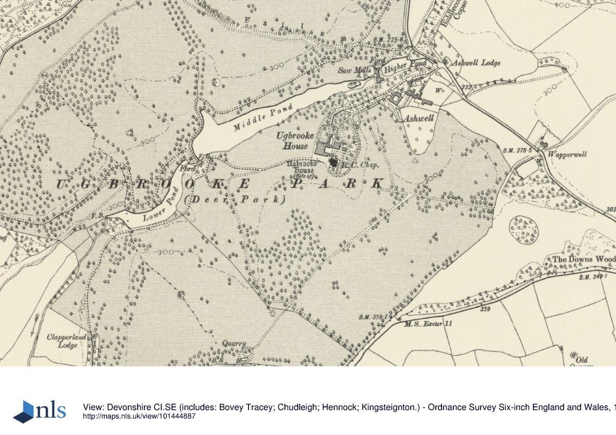
The Ugbrooke flowing through the valley to the north-west of the House is dammed to form two irregular lakes c 130m north-west and c 400m west of the House. The north-west lake or Higher Water is separated from the lower lake by a high earth dam and a picturesque rocky cascade (repaired late C20) c 380m west of the House. South of the cascade the gravelled carriage drive to Lawell which crosses the dam passes through a watersplash formed by the overflow from Higher Water and the outflow of a rocky spring immediately adjacent to the south-east. A late C20 timber footbridge adjoins the carriage drive at the watersplash. A simple stone-vaulted boathouse constructed c 1778 (Pearson Assocs 1993) survives on the south bank of Higher Water c 270m west-south-west of the House, while south of the cascade c 430m west-south-west of the House, a late C18 icehouse, also incorrectly known as Old Limekiln, survives with remnants of evergreen planting and rustic rockwork.
The quarry to the south-east of the adjacent carriage driveway is exploited as a picturesque feature (ibid). To the south-east of the quarry and c 370m south-west of the House, Dryden's Seat is a grassy knoll named to commemorate Dryden's reputed composition of The Hind and the Panther at Ugbrooke in the late C17. No structure survives today (1999), but a levelled area may be the site of an C18 seat or structure (ibid). The lakes and associated features form part of Lancelot Brown's late C18 scheme for Ugbrooke and can be dated from a series of drawings by Francis Towne to 1777-8 (private collection). The Higher Water originally extended east to the Ideford to Biddlecombe road, but in the mid C19 the upper or eastern end of the lake was separated to form a mill pool to power sawmills constructed to the north and south of the lake. Today (1999) remains of the mills, mill race and a stone bridge survive, together with a group of C20 farm buildings c 290m north-east of the House.
Brown's late C18 scheme included the diversion in 1773 of the road from Gappah to Biddlecombe to a new course north of Castle Dyke Camp (scheduled ancient monument) c 650m north-north-west of the House. The earlier course of the road across the park survives as a length of double bank c 800m north-west of the House. The drive to Lawell which crosses the dam and watersplash between the Higher and Lower Waters before running along the north side of Lower Water and turning north-west across the park also formed part of Brown's plan. Some 1.1km west of the House the Lawell drive passes through a late C18 stone arch under the late C18 Gappah to Biddlecombe road east of Winstow Cottages.
Further park drives were developed in the early C19, including a drive leading north from Higher Water to Mount Pleasant c 800m north-west of the House on the northern park boundary. Here gates flanked by massive circular-section rubble-stone piers gave access through the park wall to a circuit of walks and carriage drives in Riding Parks north-west of the road from Gappah to Biddlecombe. The Mount Pleasant drive was planted as an avenue of oaks in the late C19, some of which survive today (1999). The main road from Exeter to Newton Abbot which historically ran through the park c 530m east of the House was diverted to a new course some 500m further east and outside late C18 or early C19 parkland boundary plantations c 1830. The new road was carried over the road from Ideford to Biddlecombe on a single stone arch, Ideford Arch, which survives c 1km east-south-east of the House. Longthorn Cottage, an early C19 thatched rubble-stone cottage orné stands c 50m south-east of Ideford Arch and appears to mark the extent of the early C19 ornamental landscape. The stopping-up of the old Exeter road in the early C19 allowed the full integration of the previously established parkland bounded to the north, east and south by Ashwellhill Wood, Long Plantation and The Downs Wood into the park. These areas were once again detached when the late C20 A380 road was constructed through the park on a course slightly to the east of the earlier Exeter road.
Evidence of the early C18 park shown on Doidge's Plan of 1740 survives within the late C20 landscape. To the south-east of the House the remains of the early C18 formal avenue survives, having been formed into clumps by Brown in the late C18, while some 200m south-south-west of the House a rectangular depression enclosed by grass banks and remnants of stone rubble walls is the remains of the 'Pitt Garden' shown on the 1740 Plan.
Kitchen Garden
The kitchen garden is situated south of the principal entrance to Ugbrooke Park, some 320m north-east of the House and c 80m east of the stables. No longer in cultivation (1999), the garden is enclosed by rubble-stone walls c 3m high and to the east adjoins farm buildings and Ashwell House, a substantial two-storey house originally built c 1740 for the widow of the third Lord Clifford. To the south, a separate walled slip garden contains the remains of a lean-to glasshouse against the inner face of the north wall. A range of sheds and bothys associated with the glasshouse survives against the inner face of the south wall of the main kitchen garden. The present kitchen gardens were constructed in the mid or late C18 on the site of Ashwell Orchard, and replaced an earlier kitchen garden which lay to the south of the House and to the north-west of the Pitt Garden (Doidge, 1740).
Other Land
To the north-west of the park, beyond the late C18 road from Gappah to Biddlecombe and outside the park wall, Riding Parks, an area of woodland on a north- and north-west-facing slope above the Kate Brook was developed with a series of rides and walks in the late C18 or early C19 to take advantage of views to the picturesque Chudleigh Rocks and remains of the medieval Bishop's Palace. Riding Parks was connected to the drives within the park by a gateway at Mount Pleasant c 800m north-west of the House. To the south-west, Lawelldown Wood forms an extension of Riding Parks on the hillside above the late C18 landscaped grounds of Lawell House, which by that period was used as the Dower House. Bounded to the west by the minor road from Gappah to Chudleigh, the grounds of Lawell House comprise areas of lawn and shrubbery, with meadows and woodland to the north-east and south-west. The picturesque Lawell Drive extends from Ugbrooke Park, under the late C18 road from Gappah to Biddlecombe and thence north-west through Lawelldown Wood c 400m to Lawell House and on for some further 400m to join the main road which runs north-east to Chudleigh at a point c 2km west of Ugbrooke Park. This drive formed part of Lancelot Brown's late C18 scheme for Ugbrooke.
REFERENCES
Fr Reeve, Ugbrooke park: A Poem (1776)
R Polwhele, The History of Devonshire II, (1793-1806), pp 119-20
T H Williams, Picturesque Excursions in Devonshire II, (1815)
Gardener's Magazine 18, (1842), pp 551-2
J B Burke, Visitation of Seats ii, (1853), p 150
M Jones, The History of Chudleigh, Devon (1875)
F O Morris, A Series of Picturesque Views of Seats 2, (1880), p 67
Country Life, 142 (20 July 1967), pp 138-41; (27 July 1967), pp 203-7; (3 August 1967), pp 266-70; (5 October 1967), pp 790-3
D Stroud, Capability Brown (1975), pp 96-7, 100, 243
H Clifford, The House of Clifford from before the Norman Conquest (1987)
Ugbrooke, Chudleigh, South Devon, guidebook, (Ugbrooke Park nd)
Ugbrooke Park Restoration Plan, (Nicholas Pearson Associates 1993)
T Gray, The Garden History of Devon An Illustrated Guide to Sources (1995), pp 223-5
Maps
- William Doidge, A Plan of the Barton of Ugbrook lying in the Parish of Chudleigh... Belonging to the Rt Honble Ld Clifford..., 1740 (private collection)
- B Donn, Map of the County of Devon, 1765
- Survey Drawing, nd (c 1770), (private collection)
- Lancelot Brown (?), Plan of Ugbrooke Park, nd (c 1770), (private collection)
- Estate Plan, nd (c 1810), (private collection)
- C and J Greenwood, Map of the County of Devon, 1827
- Estate Plan, 1830 (private collection)
- Tithe map for Chudleigh parish, 1842 (Devon Record Office)
- OS Surveyor's drawing, 1810
- OS Old Series 1" to 1 mile, published 1811
- OS 6" to 1 mile: 1st edition surveyed 1886, published 1890
- OS 25" to 1 mile:
- 1st edition surveyed 1887, published 1889
- 2nd edition revised 1904, published 1905
Illustrations
- H De Cort, view of Ugbrooke Park, late C18 (private collection)
- William Tomkins, two views of Chudleigh Rocks, 1772 (private collection)
- Francis Towne, series of drawings of Ugbrooke Park, 1775 (private collection)
- Francis Towne, series of drawings of Ugbrooke Park, 1778 (private collection)
Archival items
- The Clifford family papers, including plans of the park, are held in a private collection.
Description written: July 1999 Amended: September 1999
Register inspector: JML
Edited: July 2000
- Visitor Access, Directions & Contacts
Telephone
01626 852179Website
https://www.ugbrooke.co.ukAccess contact details
The site is open to the public between July and September, but on restricted days and times. Private tours are available with more frequency.
Directions
The estate lies off the A380 between Exeter and Newton Abbot.
Owners
Lord and Lady Clifford of Chudleigh
Ugbrooke Park, TQ13 0AD
- History
The following is from the Register of Parks and Gardens of Special Historic Interest. For the most up-to-date Register entry, please visit the The National Heritage List for England (NHLE):
www.historicengland.org.uk/listing/the-list
HISTORIC DEVELOPMENT
Castle Dyke Camp, an Iron Age earthwork within the park at Ugbrooke indicates early occupation of the site. In the late C11 Chudleigh became the site of a rural palace for the bishops of Exeter, and in 1282 'a house and cerytain lands at Ugbrooke' were annexed to the Precentor of Exeter. In 1547 the Duke of Somerset, Lord Protector, obtained a lease of ecclesiastical property at Chudleigh from Bishop Voysey, and in 1550 Ugbrooke was sold to Sir Piers Courtenay of Powderham Castle, Devon (qv). When Sir Piers' widow died in 1604 Ugbrooke passed to her grandson, Thomas Clifford (1572-1634). Thomas Clifford's grandson, also Thomas, supported the Crown during the Civil War, and in 1660 was elected to Parliament as member for Totnes. Knighted in 1664, Sir Thomas was a leading political figure and served as one of Charles II's five principal ministers in the 'Cabal' Ministry in 1669. Sir Thomas was created Lord Clifford of Chudleigh in April 1672, and in November 1672 became Lord Treasurer. The following year he announced his conversion to Catholicism, resigned his public offices and retired to Ugbrooke where he died later the same year, leaving £2000 in his will to complete the rebuilding of the house. Hugh, second Lord Clifford (d 1730) came of age in 1684 and added to the woodlands at Ugbrooke and made improvements to the park, in particular planting several formal avenues in the late C17 and early C18 (Pearson Assocs 1993), which were shown on a survey by William Doidge in 1740. John Dryden was entertained at Ugbrooke and reputedly wrote The Hind and the Panther (1687) in the park. During the minority of Hugh, fourth Lord Clifford between 1732 and 1747 the family fortune was depleted through mismanagement, and it was only in 1760 that he was able to commission plans for the rebuilding of the house from Robert Adam (1728-92). The new house was begun in 1760 and finished c 1769 when the chapel and library wing was completed, also to designs by Adam. Ugbrooke was shown with a house set in a park on Donn's Map of Devon (1765) but there is no evidence that Lancelot Brown (1716-83) was consulted by Lord Clifford until c 1770 when the reconstruction of the house was complete, and at a time when Brown was working at neighbouring Mamhead Park (qv), and at Tixall Hall, Staffordshire for Lord Clifford's brother (Pearson Assocs 1993). The fourth Lord Clifford died in 1783, and was succeeded by his son, Hugh Edward, who suffered from ill health and died at Munich in 1793. His younger brother Charles, a talented amateur artist and patron of Francis Towne, Varley, Prout and Bampfylde and other artists succeeded as sixth Lord Clifford. His son, who succeeded as seventh Baron in 1831, married Mary Weld, daughter of Thomas Weld of Lulworth Castle, Dorset (qv), created Cardinal Weld in 1830, and spent much of his time in Italy, with Ugbrooke being used by several religious bodies. In 1858 the eighth Lord Clifford resumed residence at Ugbrooke, but with the estate in a near bankrupt state he was able to make only modest changes to the House and grounds. The family fortune was gradually restored before his death in 1880, but successive death duties in 1918 and 1924 again depleted the estate. During the Second World War Ugbrooke was let to an evacuated school, and from 1945 to 1952 it was used as a hostel for disabled Polish soldiers. From 1952 until the succession of the twelfth Lord Clifford who returned from Australia in 1957, the House was unoccupied, with the ground floor used as a granary. A programme of restoration was implemented by the twelfth, thirteenth and fourteenth Lords Clifford from 1957 to c 1995, and a restoration scheme for the landscape was approved in 1993, following extensive storm damage in 1990. Today (1999), Ugbrooke remains in private ownership, with Lawell House in separate private ownership.
- Associated People
- Features & Designations
Designations
The National Heritage List for England: Register of Parks and Gardens
- Reference: GD1696
- Grade: II*
Features
- House (featured building)
- Earliest Date:
- Latest Date:
- Terrace
- Description: Terraced gardens.
- Stream
- Description: The Ugbrooke, a stream which flows from north-east to west-south-west through the park.
- Boundary Wall
- Description: The site is bounded to the north and south-east by rubble-stone walls about 3 metres high which enclose the park.
- Key Information
Type
Park
Purpose
Ornamental
Principal Building
Domestic / Residential
Survival
Extant
Hectares
235
Open to the public
Yes
Civil Parish
Chudleigh
- References
References
- Stroud, D {Capability Brown} (1975) pp 96-97, 100, 243 Capability Brown (Country Life article)
- {English Heritage Register of Parks and Gardens of Special Historic Interest} (Swindon: English Heritage 2008) [on CD-ROM] Historic England Register of Parks and Gardens of Special Historic Interest
- Gray, T {The Garden History of Devon} (Exeter: Exeter University Press, 1995) 223-25 The Garden History of Devon
- Nicholas Pearson Associates {Ugbrooke Restoration Plan} (1993) Ugbrooke Restoration Plan