Introduction
Stover Park is a country house set in grounds which include some 20 hectares of gardens and pleasure grounds, and about 160 hectares of parkland, lakes and plantations. The site dates from the later 18th century to the mid-19th century.
Terrain
The site rises gradually towards its south-west corner, with extensive views north-west to Dartmoor, north-east to the Haldon Hills, and south-east to the sea at Teignmouth.The following is from the Register of Parks and Gardens of Special Historic Interest. For the most up-to-date Register entry, please visit The National Heritage List for England (NHLE):
Mid and late 18th century parkland and pleasure grounds, and mid 19th century gardens, pleasure grounds and parkland for which James Veitch provided advice.
Location, Area, Boundaries, Landform and Setting
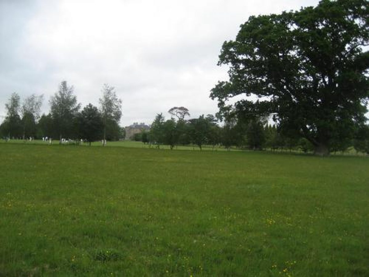
Stover Park is situated c 3km north-west of Newton Abbot, c 3km south-east of Bovey Tracey, and immediately west of the village of Teigngrace. Stover Park lies immediately to the south-east of the A38 road, which runs south-west from Exeter to Plymouth. The c 180ha site comprises some 20ha of gardens and pleasure grounds, and c 160ha of parkland, lakes and plantations. To the north the site is bounded by the late C20 A38 dual-carriageway, while to the west it adjoins the A382 road which runs south-east from Bovey Tracey to Newton Abbot; a minor road forms the north-east boundary. To the south and east the site adjoins agricultural land. The site rises gradually towards its south-west corner, with extensive views north-west to Dartmoor, north-east to the Haldon Hills, and south-east to the sea at Teignmouth.
Entrances and Approaches
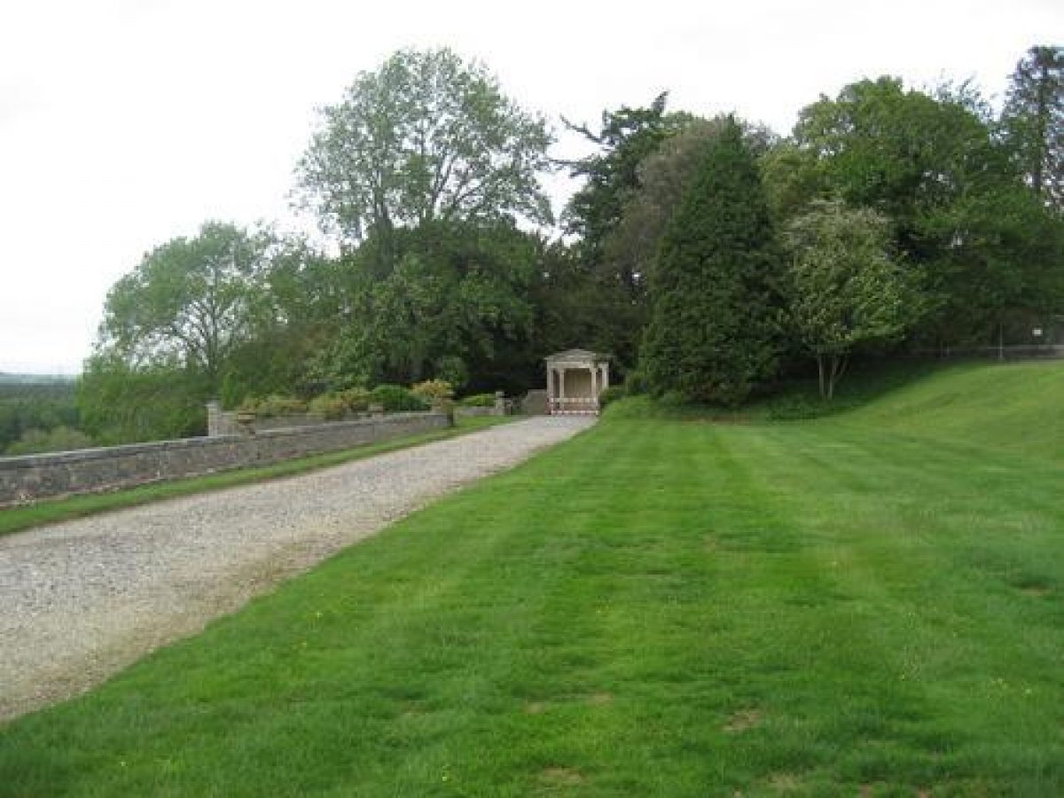
Stover Park is today (1999) approached from the A382 road which forms the western boundary of the site, at Higher Lodge which lies c 1km south-east of the junction of the A382 with the A38, and c 300m south-west of the House. Opposite this entrance, but excluded from the site here registered, is Icehouse Copse, within which stands a late C18 or early C19 icehouse (ibid). Higher Lodge (listed grade II) is a mid C19 neo-classical structure, which formed part of the improvements undertaken by the eleventh Duke of Somerset after 1829. From Higher Lodge the drive passes north-east for c 400m through the pleasure grounds, before turning north-west for c 30m to approach an elliptical carriage turn below the south-east facade of the House. Lower Lodge, standing at the south-east corner of the estate, gives access from a minor road to the west of Teigngrace village some 1.25km south-east of Stover House. The south-east drive runs north-west parallel to the site boundary for c 600m, before sweeping west through woodland and parkland for c 800m to approach the turning circle from the north-east.
From the mid C18 until the late C20, the main approach to Stover Park was from the A38 road to the north, at a point c 160m south-west of Heathfield Cross. Granite Lodge (listed grade II*) comprises a pair of single-storey Greek Doric buildings linked by a four-column screen, built c 1830 as part of the eleventh Duke of Somerset's improvements to the estate. From the Lodge the north drive leads south-east for c 500m through Newpark Plantation, crossing the outflow of the northern lake c 1km north-north-west of the House, and continuing south-south-east through Stable Copse for c 200m, before emerging into the park. Some 200m north-west of the House the drive crosses the outflow of the lower lake on a late C18 three-arched stone bridge (listed grade II), before ascending the slope to the east of the pleasure grounds to join the south-east drive at a point c 150m east of the House. As a result of late C20 upgrading of the A38 road, the north drive is today (1999) disused.
Principal Building
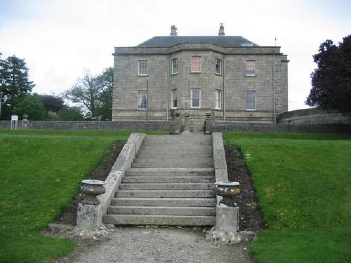
Stover House (listed grade II*) stands on an eminence at the south-west corner of the park. The House, constructed between 1776 and 1780, probably to the designs of its owner, James Templer (ibid), is an austere Palladian villa built in granite ashlar. The basement is rusticated, and canted bays extend from the north-west and south-east facades. A portico of c 1830 comprising six Greek Doric columns is connected to the south-east canted bay by curving brick walls, and is reached by a double flight of steps. To the west a quadrant wing connects the main House to a two-storey pavilion, originally containing service rooms. The pavilion, quadrant wing and south-east portico formed part of the alterations made to the House by the eleventh Duke of Somerset after his purchase of the estate in 1829. The House has been used as a school since 1932, but has been little altered.
Gardens and Pleasure Grounds
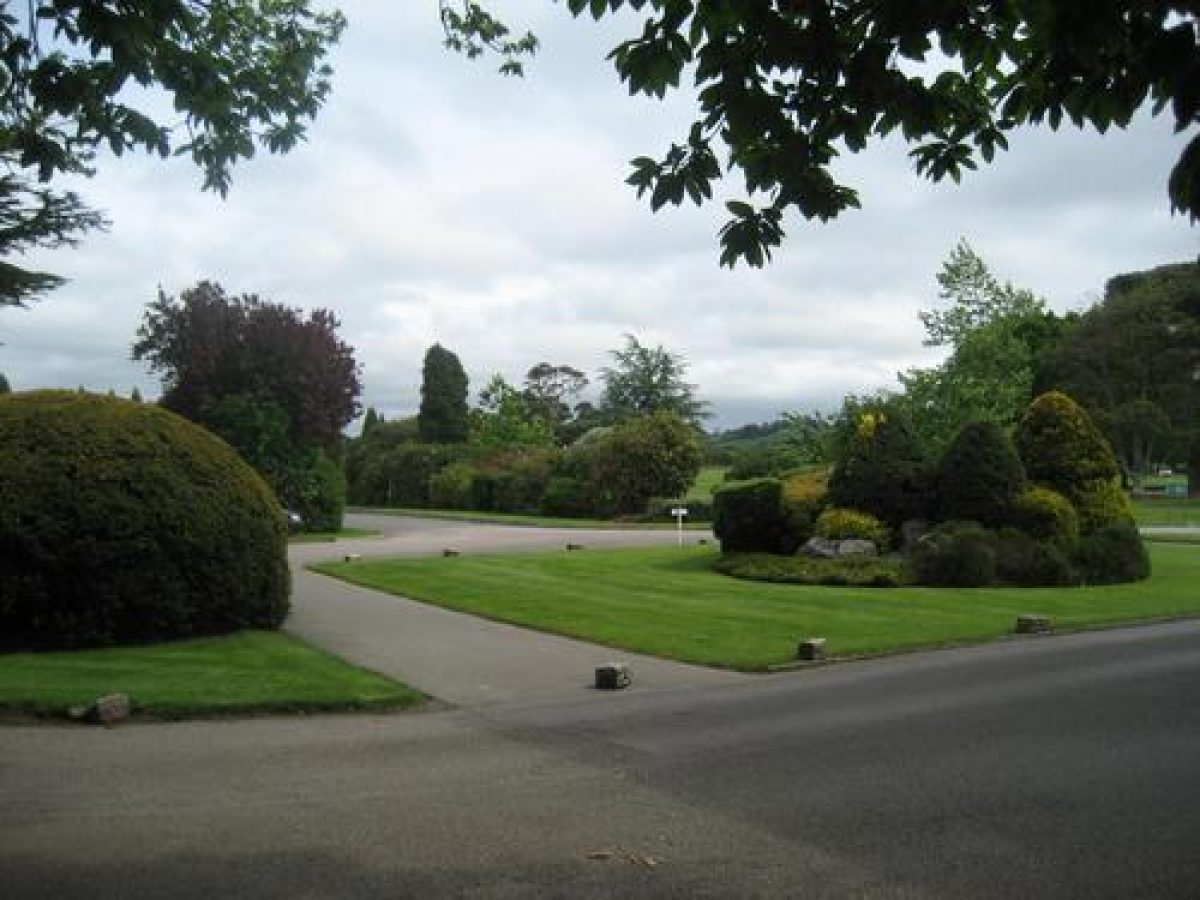
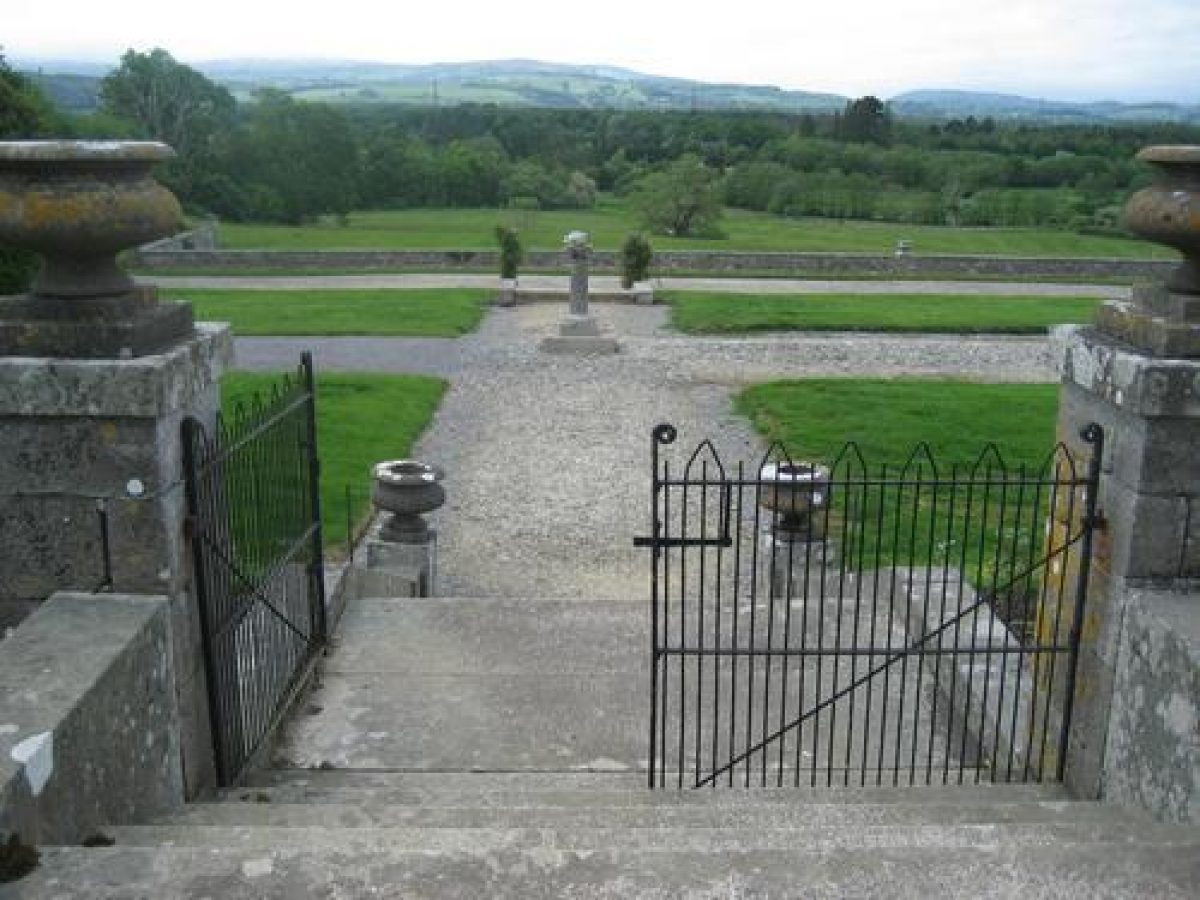
The gardens and pleasure grounds lie to the north-east of the House, with further areas of lawns and pleasure grounds to the west and south-west. Terraces below the north-west and north-east facades of the House are retained by low walls ornamented with urns (listed grade II). On the north-west side of the House two broad terraces, divided by grass banks with stone steps aligned on the canted bay on the north-west facade of the House, break the steep slope below the House. From the terraces there are views to Dartmoor across the park, from which they are separated by a stone retaining wall (listed grade II). The late C19 OS shows the upper terrace laid out with a broad walk running from south-west to north-east, and a series of rectangular flower beds. This arrangement no longer survives (1999).
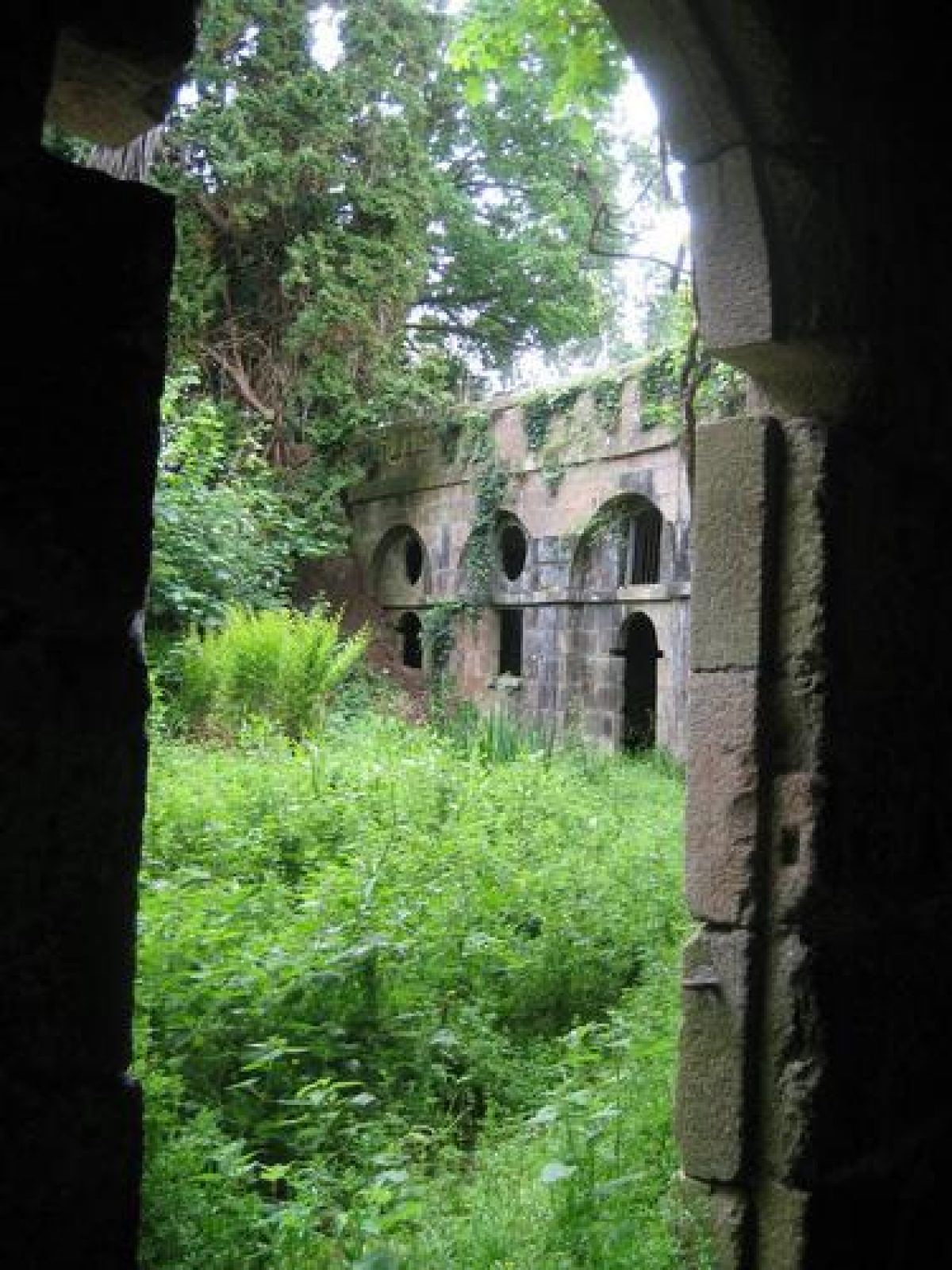
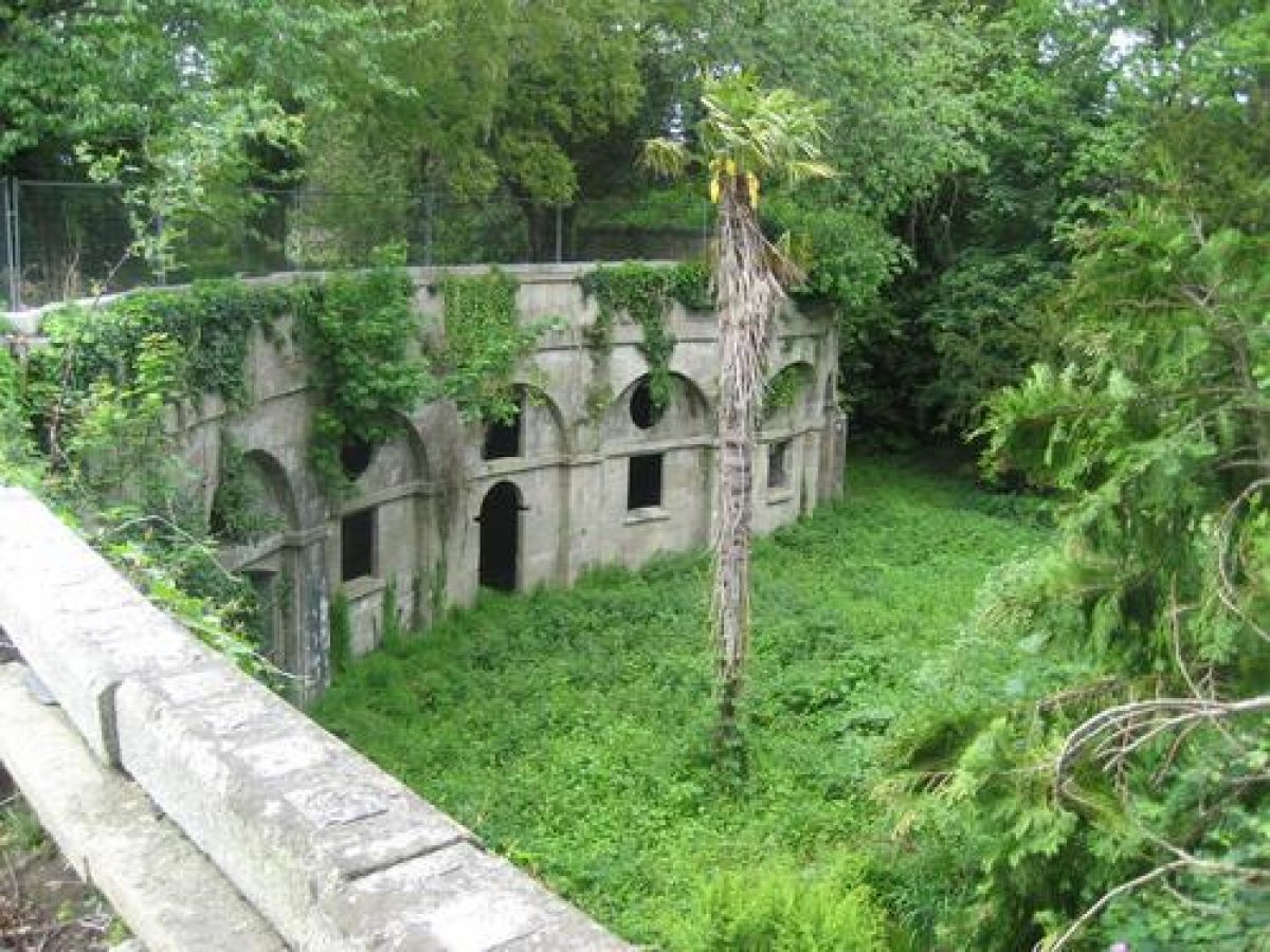
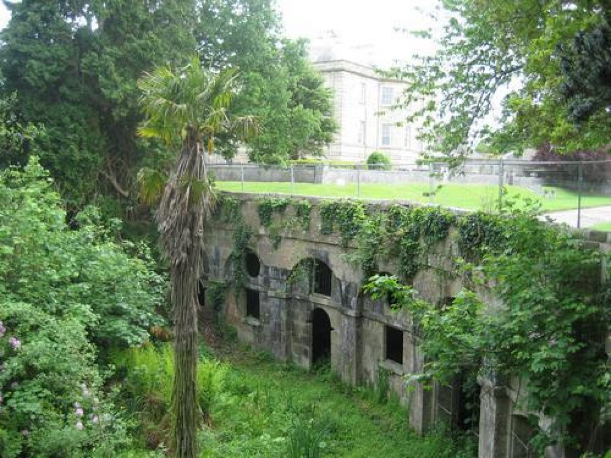
At the northern end of the lower terrace walk, c 80m north of the House, stands a small late C18 classical summerhouse built of limestone ashlar, which formed part of James Templer's design. A walk to the west of this structure leads to the main area of pleasure grounds which lie c 100m north-east of the House, below the north-east terrace. Below this terrace is an unusual grotto (listed grade II*) which is constructed from cyclopean ashlar blocks with two entrances flanked by windows set within giant arches. The interior is barrel-vaulted in rubble stone. The grotto, which lies c 80m north of the House, was formed from the stables built by James Templer in 1779 (datestone), probably as part of the eleventh Duke of Somerset's mid C19 alterations when the terraces and summerhouse were superimposed over the formerly free-standing structure. The stables are shown in their original position on the Tithe map of 1838. New stables, also known as the Clock House (listed grade II*) were built c 1840 some 250m south-west of the House. These are now (1999) used as classrooms.
An area south-west of the House is laid out as informal lawns planted with specimen trees, among which most of the mid and late C20 school buildings have been built. The largest of these, constructed c 1980, is an octagonal wooden hall designed by Pinelog Ltd.
James Veitch (1792-1863) advised the eleventh Duke of Somerset on the improvement of the gardens and pleasure grounds from 1834, with further work continuing until March 1842 (Gray 1995).
Park
To the south of the House, beyond a level area now (late C20) used as playing fields, the parkland drops away to the wooded southern perimeter. The ground also falls away to the north of the House and pleasure grounds, towards the site of the old house c 300m north-west of the late C18 mansion, and the serpentine lake beyond. This is the lower, and smaller of two lakes, and is formed by the damming of the Liverton Brook which runs from west to east across the centre of the park. The 5.6ha irregular Stover lake c 1.25km north-west of the House is formed by the damming of the Ventiford Brook.
James Templer was responsible for draining the former heathland and also for the creation of the lakes. It has been suggested however that the southern lake formed part of an ornamental landscape associated with the earlier house, and that Stover Bridge (listed grade II) which carries the Bovey Tracey to Newton Abbot road over the inflow, is part of this scheme (Gray nd). Stover Bridge was, according to a partially legible datestone, constructed in 1773 or 1775. The northern lake is probably a later addition, dating from the expansion of the park northwards, and may have been connected with work on the Stover Canal which was begun in 1790 to the east of the site.
The park today (1999) remains pasture with scattered individual trees and ornamental clumps. The open parkland to the north and south of the House is enclosed by extensive plantations. To the west the A382 road is screened by boundary planting including Blacksticks Plantation c 1km north-west of the House, while to the north Newpark Plantation forms a triangular block of woodland between the A38 road and the minor road which forms the site boundary to the north-east. Stable Copse, Goilmore Plantation and New Orchard Copse together with other woodland, encloses the park to the east.
Plantations around the House were established by the 1780s, when an estate plan (published 1803) showed a network of walks through the woodland. The plantations were expanded by James Templer II in the late C18 and early C19, and again by the dukes of Somerset from 1829, with advice from James Veitch in the 1830s and early 1840s. The expansion of the plantations continued into the C20, when the woodland around Stover Lake was acquired by the Forestry Commission for commercial timber production.
Kitchen Garden
An irregular-shaped walled kitchen garden lies c 150m west of the House and immediately to the north of the Clock House, to which its walls are integrally linked. The late C19 OS map shows an arrangement of large beds separated by walks with glasshouses built against the inner face of the north-west wall, and a range of sheds and stores on the outer face of the north wall. A free-standing glasshouse is shown c 80m north-east of the stables, to the south of a group of conifers on the east side of the walled garden. The kitchen garden appears to have formed part of the eleventh Duke of Somerset's mid C19 alterations to Stover.
REFERENCES
R Polwhele, The History of Devonshire II, (1793-1806), p 149; III, p 497
W Hyett, Guide in a Tour to the Watering Places (1803), p 56
W Hyett, A Guide to the Watering Places on the Coast Between the Exe and the Dart (1817), p 17
H St Maur Seymour, Annals of the Seymours (1902)
Devon and Cornwall Notes and Queries 13, (1924-1925), pp 326-330, 357-358; 14, (1926-1927), pp 18-19; 20, (1939), pp 280-283
A J Key, Stover: the Story of a School (1982)
B Cherry and N Pevsner, The Buildings of England: Devon (1989), pp 768-769
T Gray, The Garden History of Devon An Illustrated Guide to Sources (1995), pp 212-213
T Gray, unpublished report on Stover Park [copy on EH file]
Maps
- Tithe map for Teigngrace parish, 1838 (Devon Record Office)
- OS 6" to 1 mile: 1st edition surveyed 1887, published 1889
- OS 25" to 1 mile: 1st edition surveyed 1887, published 1889
- 2nd edition revised 1904, published 1905
Archival items
- Templer estate, legal and family papers, early C19 (924b/E), (Devon Record Office)
- Seymour estate papers, mid to late C19, including correspondence with James Veitch (1392M), (Devon Record Office) Estate sale particulars, 1912 (West Country Studies Library)
- Estate sale particulars, 1921 (547B/2067), (Devon Record Office)
Description written: August 1999
Amended: October 1999
Edited: July 2000
- Visitor Access, Directions & Contacts
Access contact details
The site is open daily for general public use.
Directions
The park is off the A382 Newton Abbot road. https://new.devon.gov.uk/stovercountrypark/location
Owners
Devon County Council
County Hall, Topsham Road, Exeter, EX2 4QD
- History
The following is from the Register of Parks and Gardens of Special Historic Interest. For the most up-to-date Register entry, please visit the The National Heritage List for England (NHLE):
www.historicengland.org.uk/listing/the-list
HISTORIC DEVELOPMENT
The Stover estate, comprising an existing house known as Stover Lodge and an extensive tract of heathland, was purchased in 1765 by James Templer. The son of an Exeter tradesman, Templer had been apprenticed to an Exeter architect, John Bickley, and subsequently made his fortune erecting government buildings in Madras and Plymouth in partnership with Thomas Parlby and Henry Line. Stover Lodge was demolished and between 1776 and 1780 James Templer erected a new house, probably to his own design (Cherry and Pevsner 1989), on a new site to the south of the earlier building. A plan of the estate drawn in the 1780s (Devon Record Office) shows extensive gardens round the new house with walks through adjacent plantations.
On James Templer's death in 1782, Stover passed to his son, also James (d 1813), who with his brothers George and John was responsible for the reconstruction of Teigngrace church in 1787. James II also constructed the Stover Canal to the east of the park in 1790-1792, to the designs of Thomas Gray. The canal ran from Newton Abbot to Ventiford, and was used to irrigate and drain land around Stover, and to carry ball clay and, after 1820, granite from the Haytor quarries on Dartmoor, which were owned by the family (Cherry and Pevsner 1989).
James II's brother, George (d 1843), inherited Stover in 1813, and in 1829 sold the estate to the eleventh Duke of Somerset. The Duke made alterations to the House in about 1830, and by 1834 had consulted James Veitch on improvements to the pleasure grounds and gardens. Stover was sold by the fourteenth Duke of Somerset in 1932 and the House was converted into a girls' school, in which use it continues today (1999). Parkland and woodland was acquired by the Forestry Commission, which in 1979 sold some 114 acres (47.5 hectares) to Devon County Council for use as a country park. The site remains in divided corporate ownership today (1999).
Period
- 18th Century (1701 to 1800)
- Late 18th Century (1767 to 1800)
- Associated People
- Features & Designations
Designations
The National Heritage List for England: Register of Parks and Gardens
- Reference: GD 2286
- Grade: II
The National Heritage List for England: Listed Building
- Reference: Granite Lodge
- Grade: II*
The National Heritage List for England: Listed Building
- Reference: Grotto
- Grade: II*
The National Heritage List for England: Listed Building
- Reference: Higher Lodge
- Grade: II
The National Heritage List for England: Listed Building
- Reference: Stover Bridge
- Grade: II
The National Heritage List for England: Listed Building
- Reference: Stover Park
- Grade: II*
Features
- House (featured building)
- Description: The house is now in use as a girls' school.
- Earliest Date:
- Latest Date:
- Lake
- Plantation
- Gardens
- Parkland
- Key Information
Type
Park
Purpose
Recreational/sport
Principal Building
Parks, Gardens And Urban Spaces
Period
18th Century (1701 to 1800)
Survival
Extant
Hectares
180
Open to the public
Yes
Civil Parish
Teigngrace
- References
References
- {English Heritage Register of Parks and Gardens of Special Historic Interest} (Swindon: English Heritage 2008) [on CD-ROM] Historic England Register of Parks and Gardens of Special Historic Interest
- Pevsner, N {The Buildings of England: Devon} (Harmondsworth: Penguin, 1952) The Buildings of England: Devon
- Gray, T {The Garden History of Devon} (Exeter: Exeter University Press, 1995) 212-3 The Garden History of Devon
- John Francis Bucknall Architects with Pat Grover Historic Landscape Consultant {Stover Park Conservation Management Plan} (2006) Stover Park Conservation Management Plan
- Askew Nelson {Stover Park Parkland Plan} (2014) Stover Park Parkland Plan
- Related Documents
-
ClS 1/411/1
Conservation Management Plan (Vol.1 of 3) Interim Executive Summary - Hard copy
John Francis Bucknal, Architects, with Pat Grover,Historic Landscape Consultant - 2006
-
CLS 1/528
Parkland Plan, 1st Draft - Digital copy
Askew Nelson Ltd - 2013
-
CLS 1/583
Parkland Plan - Digital copy
Askew Nelson Ltd. - 2014
-
CLS 1/584
Parkland Plan, Vol.2: Maps and Plans, A - J - Digital copy
Askew Nelson Ltd. - 2014
-
CLS 1/585
Parkland Plan, Vol.3: Appendices A - J - Digital copy
Askew Nelson Ltd. - 2014
-
ClS 1/411/1