Introduction
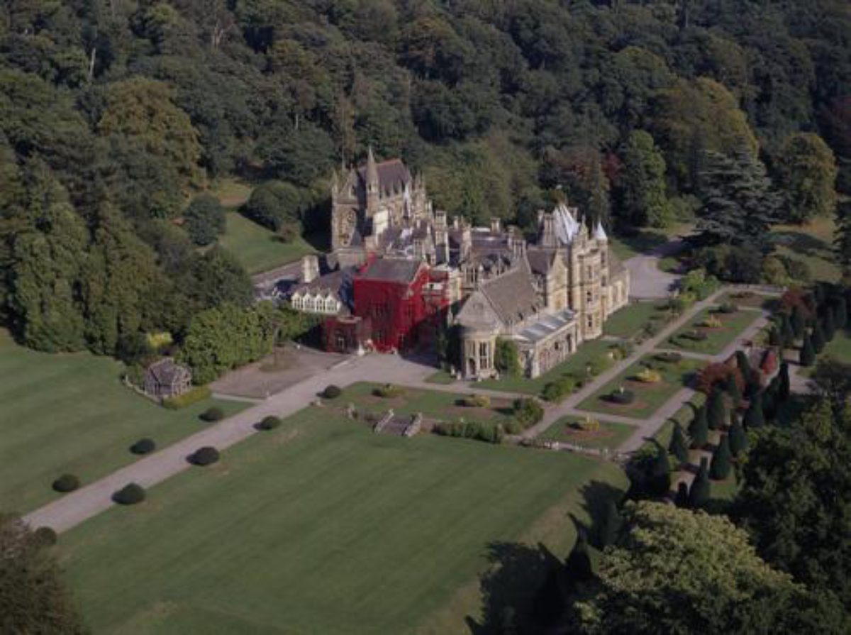
Tyntesfield has formal terraced gardens and pleasure grounds of around 12 hectares, set within a landscape park of 130 hectares. There are kitchen gardens, garden buildings and ornaments dating from 1885, by Sir Walter Cave.
There are formal terraced gardens and pleasure grounds of some 12 hectares. This includes three terraced walks linked by broad flights of steps. Plantings include Irish yews, Portuguese laurels and hollies.
Terrain
The site occupies a south- and south-west-facing slope which descends from the northern boundary wall to the more level park south of the mansion.
There is an enclosed rose garden backed by trees. Features include two summerhouses, retaining walls, ornamental balustrades and steps flanked by heroic animals (probably dating to 1910). There is a Gothic seat, probably designed by John Norton around 1865.
The parkland is undulating with scattered trees, tree clumps and a lake. Woodland walks extend into the park.
The following is from the Register of Parks and Gardens of Special Historic Interest. For the most up-to-date Register entry, please visit The National Heritage List for England (NHLE):
Location, Area, Boundaries, Landform and Setting
Tyntesfield is situated c 5km west of Bristol and c 1km south-east of the village of Wraxall. The c 250ha site is bounded to the south and south-west by the B3130, Clevedon Road, from which it is separated by C19 metal estate fences and hedges, while to the south-east and east it adjoins the B3129 road, known variously as Belmont Hill and Flax Bourton Road. The site is here bounded by C19 stone walls which return along the northern boundary, separating the designed landscape from agricultural land south of the B3128 road. To the west the site adjoins woodland and further agricultural land.
The site occupies a south and south-west-facing slope which descends from the northern boundary wall to the more level park south of the mansion, allowing wide views south across the valley of the Land Yeo river towards high ground c 3km south including the park associated with Barrow Court (qv), and south-west across the Vale of Nailsea towards the Bristol Channel c 10km west of Tyntesfield. A group of mid C19 estate cottages and almshouses, perhaps designed by Norton, adjoin the park to the south-west.
Entrances and Approaches
In 2002 there were three principal entrances to the site, situated to the north, south, and south-south-east of the mansion. In addition there are further entrances, generally disused, to the north-east, east, and south-east.
The north or Upper Lodge entrance is situated on the B3128 road at a point c 0.75km south-east of its junction with a minor road, Wraxall Hill. Stone piers support a pair of wrought-iron carriage gates, while a two-storey picturesque Gothic-style stone lodge stands immediately east of the entrance (all listed grade II). The Upper Lodge and entrance appear to have been constructed as part of the mid C19 improvements designed by John Norton. Beyond the entrance a straight tarmac drive extends c 375m south between wide grass verges planted with an outer avenue of mature limes and an inner avenue of topiary yew drums (hard pruned 2002). The drive is adjoined to east and west by agricultural land, from which it is separated by metal estate fencing.
Entering the main body of the designed landscape, the drive drops gently south-east for c 400m to reach a drive leading west to the Home Farm, which is partly screened from the drive by an ornamental plantation. Beyond the Home Farm drive, the north drive leads east, passing along the northern boundary of the pleasure grounds and to the north of the Chaplain's Lodge and Chaplain's House (both listed grade II). The Lodge is a mid C19 picturesque Gothic-style stone structure, while the attached Chaplain's House is a more substantial late C19 Arts and Crafts-style building, perhaps designed by Henry Woodyer for the accommodation of the Gibbs' private chaplain.
The drive sweeps south-east, passing to the south of the lower end of Bendle Combe; there are picturesque views from the drive along the Combe. Continuing south-east round the north-east side of the mansion and chapel, the drive reaches a junction c 130m south-east of the house, from which a service drive leads north-west to the service court on the north side of the house. The court is entered through an arch supporting a passage linking the house to the chapel, and contains a set of mid C19 Gothic-style wrought-iron dog kennels. A further drive leads west from the junction to reach an extensive gravelled carriage turn below the east façade of the mansion.
The south drive enters the site from the B3130, Clevedon Road at a point c 1km south-east of Wraxall. A pair of wrought-iron carriage gates is adjoined to the south-east by Lower or Wraxall Lodge (listed grade II), a single-storey, mid C19 picturesque Gothic-style stone lodge. This building appears to have formed part of Norton's mid C19 improvements to the estate. From the Lodge the drive, lined by an avenue of limes, sweeps north-north-east through the park to reach an inner lodge, Drive Cottage (listed grade II), which is situated west of the kitchen garden. This two-storey stone lodge is built in a picturesque Gothic style with ornamental bargeboards. It is shown as an entrance lodge to the estate on the Tithe map (1837) and therefore pre-dates both Norton's mid C19 improvements and Gibbs' extension of the early C19 park. Beyond Drive Cottage the drive sweeps east and north through an area of ornamental shrubbery and mature specimen trees to reach the junction with the north and south-south-east drives c 130m south-east of the mansion.
The south-west or Wraxall Drive appears to have been developed in the mid C19, probably as part of William Gibbs' programme of improvements, replacing an existing early C19 drive shown on the Tithe map (1837) which followed a different course, sweeping north and east across the park south of the early C19 house. This earlier drive is not shown in Matilda Gibbs' watercolour view of Tyntesfield from the south-west (c 1850, reproduced CL 2002), and had presumably been removed by that date.
The south-south-east or Station Drive leads into the site from B3130 road at a point c 270m north-west of its junction with the B3129 road. An ornamental timber gate is supported by monumental stone piers, one of which forms a buttress attached to the west façade of Station Lodge (listed grade II), a single-storey Arts and Crafts-style stone and half-timbered lodge. This building was designed c 1900, perhaps by Reginald Blomfield as the entrance to a new drive intended to give access to the railway at Flax Bourton. Station Drive extends c 800m north-north-west through an avenue of oaks, with views west across the park and east towards Belmont, before reaching a junction with Belmont Drive, which leads east and south-east to Belmont and Belmont Lodge (listed grade II). The latter structure, a single-storey, picturesque mid C19 stone building, gives access to the site from the B3129, Belmont Hill. Belmont Drive originally served Belmont, which until the mid C19 was a separate estate.
Beyond the junction with Belmont Drive, Station Drive continues c 530m north-west, passing to the north-east of the stables, to reach the drive junction c 130m south-east of the mansion. The stables (listed grade II) are designed around two courtyards, the outer or western court being entered between monumental Gothic-style stone piers surmounted by wrought-iron lamp standards, and having a central decorative Gothic-style octagonal raised pool and fountain (all listed grade II). The inner or eastern court is entered through an archway surmounted by a half-timbered gable and contains carriage houses with glass-roofed awnings, one of which is converted into an early C20 motor house. To the east of the stable courts is a detached late C19, two-storey Arts and Crafts-style stone cottage (listed grade II). The stables and cottage were constructed c 1880 to a design by Henry Woodyer, replacing earlier stables on the site (OS c 1880) which had themselves replaced a structure shown on the Tithe map (1837).
Principal Building
Tyntesfield (listed grade I) stands on an artificially levelled terrace towards the centre of the site, below a south-facing wooded slope. To the south of the house the ground falls away through the park towards the southern boundary of the site. The house is constructed in ashlar under Cotswold stone, slate, and lead roofs, and is executed in an asymmetrical Perpendicular Gothic style. The east or entrance façade has at its southern end a projecting single-storey gabled wing with an elaborate canted bay window. To the north of this wing is a monumental gothic entrance arch and porch; this was originally surmounted by a tall pinnacle tower with a high pyramidal roof. This structure was removed in the early C20.
The porch is adjoined to the north by a series of three full-height canted bay windows, above which are attic dormers. A further wing terminating in a circular turret projects at the north-east corner of the building, shielding the entrance to the service court which is formed by an arched bridge at first-floor level which provides access to the chapel which stands slightly detached from the house at its north-east corner. The main body of the Gothic-style stone chapel is situated at first-floor level above a basement and crypt. The chapel was designed by Sir Arthur Blomfield in 1873, and was inspired by the Sainte-Chapelle, Paris and Gilbert Scott's chapel for Exeter College, Oxford (CL 2002).
The garden or south façade of the house is a balanced but asymmetrical composition with a central three-storey tower with a full-height canted bay window and steeply pitched pyramidal roof, which is flanked to east and west by three-storey gables and single-storey wings. The western wing has an open gothic loggia extending across its full width. The west façade is similarly asymmetrical with a single-storey wing terminating in a segmental bay window extending from the south-west corner of the house.
The interior of the house retains important mid C19 decorative schemes and furniture by J G Crace, together with later C19 schemes by Henry Woodyer and James Plucknett of Warwick. The naturalistic motifs carved in the stonework by Mr Beates were derived from local plants and those found in the gardens, echoing William Gibbs' interest in natural history and botany (ibid). At the north-west corner a low stone wall encloses a rectangular area of gravel which corresponds to the site of the mid C19 conservatory demolished in 1916. This structure, surmounted by a dome said to be modelled on that of S Marco, Venice (The Builder 1866), made use of a pale-green tinted glass devised by Sir William Hooker for use in the Palm House at Kew (qv) (ibid).
The present mansion was designed for William Gibbs in 1863 by the London and Bristol architect John Norton. The building was constructed by William Cubbitt & Co of London, and was completed by 1865, and the following year was described in The Builder. This structure represents the radical remodelling and extension of a gothic villa built for the Rev George Seymour in 1836-40 by Robert Newton of Nailsea (CL 2002).
Gardens and Pleasure Grounds
Formal terraces to the south and west of the house lead to extensive informal pleasure grounds, with a further detached formal garden to the north-west of the house. An extended network of walks and rides runs through ornamental plantations on the south- and south-west-facing slopes to the north and north-east of the house, while there are further pleasure grounds associated with Belmont c 1km south-east of Tyntesfield.
The formal gardens are separated from the carriage court to the east of the house by a mid C19 stone wall and balustrade designed by John Norton (listed grade II). An elaborate pair of wrought-iron gates supported by stone piers lead south to a flight of stone steps which descends from the carriage court to the second terrace, while a single wrought-iron gate in the form of a letter 'W' (for Lord Wraxall) surmounted by a baron's coronet set adjacent to the south-east corner of the house leads west to the upper terrace.
The upper terrace is laid to grass and extends the full width of the house before returning below the west façade. A flight of stone steps placed on the central axis of the south façade, and a further, similar flight of steps c 20m south-west of the house, descend from the upper terrace to the second terrace. This terrace is terminated to the east by a stone balustrade which allows views across the park, while to the west a similar balustrade separates it from the tennis lawn. The terrace has a symmetrical plan with gravel walks surrounding and separating a pair of rectangular lawns which are flanked to east and west by a pair of square lawns. Each lawn has a centrally placed geometric flower bed for seasonal planting, at the centre of which stands a mid C19 stone urn, the base of which is encircled by either green or golden clipped holly.
To the north, the stone retaining wall of the upper terrace is planted with climbers and tender shrubs. The layout and planting of the second terrace corresponds to that shown in early C20 photographs (ibid). From the second terrace a double flight of stone steps descends to the level of the pleasure grounds. Here, a gravel walk flanked by an avenue of mature Irish yews extends c 225m from east to west above a gently sloping south-facing lawn which is planted with mature specimen trees, conifers, and groups of ornamental shrubs. The Yew Walk is terminated to the east by a stone Gothic-style seat (listed grade II), the design of which is attributed to Norton, while a similar seat (listed grade II) is situated at the western end of the walk. Early C20 photographs show that the Irish yews formerly alternated with yuccas (CL 1902; Gardener's Mag 1908). The Yew Walk at Tyntesfield inspired a similar feature created by William Gibbs' nephew, the Hon Vicary Gibbs (1853-1932), at Aldenham House, Hertfordshire (qv) (SAVE 2002).
Below the Yew Walk a gravel walk leads c 30m south, continuing the central axis of the south terraces, to reach a rock-edged circular bed which forms a rondpoint punctuating an avenue of Portugal laurels which line a further east/west gravel walk. To the east, this walk is terminated by a further mid C19 stone gothic seat (listed grade II), while to the west it leads to an area of lawn immediately east of a small informal lake. The late C19 OS map shows that this area was formerly laid out as a further rondpoint terminating the Laurel Walk (OS c 1880).
The Portugal laurels are small trees (2002), but were originally clipped as domed standards. The southern axis of the south terraces is terminated c 100m south of the house by a further rondpoint planted with a mature specimen oak. From this point a walk leads south-east to a wrought-iron gate on the boundary of the pleasure grounds which gives access to a path extending south-east and south across the park to reach a private gate leading to the kitchen garden. The southern boundary of the pleasure grounds is formed by a stone ha-ha which allows views out across the park. The line of the ha-ha appears to have been altered in the late C19 when the southernmost rondpoint and the walk leading to the kitchen garden were constructed, probably coinciding with the remodelling of the kitchen garden in 1896 (OS c 1880, 1903).
The artificial lake c 100m south-west of the house is of irregular outline, and has groups of ornamental trees and shrubs planted to the south and north-west. Lined in the mid C20 with concrete, the lake is now dry (2002). A walk extends along the northern and western shores of the lake, with rockwork, some possibly of artificial construction, retaining the higher ground to the north and north-west of the lake. Rock steps ascend from the walk to reach areas of lawn planted with mature specimen trees and groups of ornamental shrubs. The lake appears to have been constructed in the mid C19 as part of the development of the pleasure grounds by William Gibbs. It is shown in its present form on the late C19 OS map (c 1880), and in early C20 photographs (CL 1902; private collection).
The upper terrace returns below the west façade of the house with a gravel walk leading north from the steps at the south-west corner of the house to reach a rectangular gravelled area north of the drawing-room wing. To the west of this walk is a panel of lawn with a symmetrical pair of geometric flower beds for seasonal planting. Each bed surrounds a mid C19 stone urn which is encircled by clipped golden holly; this planting corresponds to that shown in early C20 photographs (CL 1902). This lawn is retained by a stone wall and balustrade, with a centrally placed wide flight of stone steps descending from the lawn to a double tennis lawn. The lawn is bordered to the south by a steep grass bank which descends to the level of the Yew Walk, while to the west a further grass bank descends to a second tennis lawn, part of which is now occupied by a mid C20 hard-surfaced tennis court.
The gravelled area to the west of the house is adjoined to the north by the site of the mid C19 conservatory. The area within the low stone walls which formerly supported the elaborate glass superstructure is laid to gravel with a central octagonal stone-kerbed panel of grass surrounding a mature Chusan palm. The high stone wall to the north is planted with mature camellias, magnolias, and other ornamental shrubs. Immediately north-west of the site of the conservatory, a single-storey timber and tile-roofed rustic aviary (listed grade II) stands within a small hedged enclosure. The aviary is shown on late C19 and early C20 photographs (private collection; CL 1902). From the gravelled area west of the house a formal gravel walk flanked by an avenue of low standard hollies clipped into domes extends c 160m west to reach an elaborate mid C19 stone Gothic-style seat (listed grade II). Attributed to John Norton, this seat is flanked by a pair of mature columnar conifers. Beyond the seat, informal curvilinear walks sweep west and north through an undulating area of lawns planted with an extensive collection of mature specimen trees and conifers, and groups of ornamental shrubs. Known as 'Paradise' (OS c 1880), this area appears to have been developed by William Gibbs as an arboretum in the mid C19, with careful attention being paid to the mixture of evergreen and deciduous species used, together with contrast in form and foliage colour. A depression c 250m west of the house is planted with a group of mature palms, the remnants of a late C19 exotic garden.
Some 130m north-west of the house, and approached by a walk leading north from the Holly Walk, is a further detached area of formal garden set into the south-facing slope at the southern end of Bendle Combe. The Rose Garden comprises an artificial terrace retained to the south by brick walls surmounted by stone parapets, and is approached by a flight of stone steps flanked by a pair of stone heraldic lions (all listed grade II). The garden is laid out to a symmetrical plan with a central walk passing beneath C19 metal rose arches dividing the terrace into two parterres comprising box-edged beds separated by gravel walks. A pair of rustic timber and tile-roofed octagonal summerhouses (listed grade II) stands at the north-west and north-east corners of the parterre terrace, each with Minton tiles on the walls and ornamental tiled floors.
The Rose Garden is enclosed to the west by mixed shrubbery, while to the east a rocky bank ascends to further shrubbery. To the north a stone wall broken by a centrally placed flight of stone steps (all listed grade II) ascends to an upper terrace comprising a gravel walk ornamented with four circular planting areas formed from the inverted stone treads of a spiral staircase. The remains of a large, mid C19 stone composition urn stand at the top of the steps ascending from the parterre terrace. Above the terrace walk a south-facing sloping lawn is enclosed to the north by a semicircular yew hedge. The Rose Garden appears to have been constructed in the mid C19, probably to the design of John Norton (listed building description), and occupies the site of two rectangular enclosures shown on the Tithe map (1837).
To the east of the Rose Garden, a walk flanked by rockwork and shrubbery ascends to a gate leading to the north or Clevedon Drive. Beyond the drive informal walks ascend through ornamental plantations to the east and west of Bendle Combe, to reach a mid C19 octagonal stone summerhouse (listed grade II) c 450m north of the house. This substantial structure has mullioned windows set in the south and east façades and a pyramidal tiled roof carried forward from the walls to form a verandah supported by rustic poles. The roof surrounds a central octagonal lantern in which are set further small windows. The interior of the summerhouse is panelled, with provision for a fireplace (missing, 2002), and contains a large mid C19 rustic table formed from a section of tree trunk, supported by further trunks forming short legs. The summerhouse is surrounded by mature evergreen shrubbery and specimen trees including monkey puzzles; apparently constructed to the design of John Norton, it formerly allowed views south along Bendle Combe towards the pleasure grounds and park west of the house.
To the north of the summerhouse a drive extends from west to east parallel with the stone boundary wall forming the northern boundary of the site. This drive links the north or Clevedon Drive and Belmont Cottage (ruinous, 2002) at the north-east corner of the site, passing an early or mid C19 single-storey picturesque stone lodge (ruinous, 2002; listed grade II) c 30m north-north-west of the summerhouse, and the more substantial early or mid C19 picturesque Keeper's House (ruinous, 2002; listed grade II) c 670m south-east of the summerhouse. Further parallel walks and rides extend from west to east through the mature mixed woodland on the south- and south-west-facing slopes to the north and east of the house, linking three combes which form grassy glades allowing views south from the woods to the park. This network of walks and rides was established by c 1880 (OS), and was probably developed from c 1840 by William Gibbs.
Approximately 1km south-east of Tyntesfield, Belmont (listed grade II), a substantial house of late C18 origin, stands in its own pleasure grounds. To the north-west of the house is an area of lawn enclosed by a carriage drive, with late C18 stables and associated cottages (listed grade II) to the north. The stables are adjoined to the north-west by the late C18 kitchen garden which is enclosed by rubble-stone walls c 3m high (listed grade II); the walls to the north-east, at the upper end of the sloping garden, are built to a semicircular plan. To the south-east of the house is an area of lawn surrounding the remains of a rectangular pool. An opening surrounded by rustic stonework leads to a subterranean chamber set into the steep south-west-facing slope to the north-east of this lawn. This slope is planted with mature trees and evergreen shrubs, through which pass the remains of a network of walks. A formal walk lined with an avenue of yews leads c 130m south-east from Belmont house to a stone monument (listed grade II) in the form of a sarcophagus placed on a stone pedestal; this was erected in 1778 by William Turner of Belmont to commemorate his friend, Joseph Farrell (inscription).
The pleasure grounds surrounding Belmont were laid out in the late C18 by William Turner, and included extracts from the poems of the Somerset poet and philanthropist, Hannah More (1745-1833), to whom he had once been engaged (DNB), which were painted on wooden tablets (Bond 1998). Belmont was leased to George Gibbs in 1828, and was subsequently purchased by his cousin, William Gibbs, in the mid C19. Gibbs occupied Belmont during the rebuilding of Tyntesfield in the early 1860s, and subsequently the house became a secondary dwelling on the estate.
Park
The park is principally situated on gently sloping south- and south-west-facing ground to the south and south-east of the house, with further, smaller areas of park lying on higher ground to the north-west of Tyntesfield and to the north-east of Belmont. In 2002 the park was in mixed agricultural use, with areas of pasture remaining to the south of the mansion, and areas of arable cultivation to the north and south-east.
The park retains many scattered mature trees, some of which survive from earlier field boundaries (Tithe map, 1837); others formed part of an extensive mid C19 planting programme. The Tithe map (1837) and mid C19 watercolour views (private collection, reproduced in CL 2002; SAVE 2002) indicate that parkland had been developed to the south and west of the house built by the Rev George Seymour in 1836-40. This early C19 park extended south, approximately to a line extending west from the kitchen garden (Tithe map, 1837), and was subsequently enlarged to its present extent by William Gibbs in the mid C19. The park had achieved essentially its present form by the late C19 (OS c 1880).
The Home Farm (listed grade II*) is situated in the park c 450m west-north-west of the mansion. The farm comprises an early or mid C19 picturesque stone farmhouse (listed grade II), with a range of stone stables to the north-east and an extensive covered stock yard and open yard to the north. A walk leads east from the farm to enter the pleasure grounds c 400m west of the mansion, and continues to join the western end of the Holly Walk. The model farm was developed in the mid and late C19, incorporating the latest agricultural technology. Many of these features, including patent cast-iron cattle stalls, survive in the farm buildings.
Kitchen Garden
The kitchen garden is situated c 400m south-south-east of the mansion, to the south of the Wraxall Drive. The garden comprises two principal enclosures: to the north a smaller partly ornamental section with extensive ranges of glasshouses and an orangery, and a larger productive garden to the south. There are further areas of orchard to the east and south-east.
The principal approach to the garden in 2002 was from the north-east adjacent to The Bothy (listed grade II), a single-storey, red-brick lodge of Neoclassical design. This structure forms part of the late C19 remodelling of the kitchen garden, and was probably designed by Reginald Blomfield. The northern garden is enclosed to the north and west by brick walls c 4m high, each supporting connected ranges of three-quarter span brick and metal-framed glasshouses, which remain (2002) in use. These were constructed in 1896 by W G Smith of Ipswich using a glazing system patented in 1879 by G Beard & Son of Bury St Edmunds (SAVE 2002), replacing a range of glasshouses on approximately the same site which had been supplied by Henry Ormson of Chelsea c 1870 (ibid).
To the south the northern garden is enclosed by a Neoclassical-style range of brick and stone bothies, stores, and other associated structures. The north façade of this range is broken by regularly spaced stone piers surmounted by ball finials, while two symmetrically placed arched entrances surmounted by pediments give access to the rooms and the southern garden enclosure beyond. The design of the bothies, which were constructed in 1896, is attributed to Reginald Blomfield (listed building description).
To the east, the northern garden is partially enclosed by an ornamental Neoclassical-style orangery (listed grade II*) comprising arched windows separated by engaged stone columns, flanking a central arched doorway surmounted by a pediment. The stonework of the orangery is today in poor condition, although the interior appears to remain intact (2002). The central section of the northern garden is laid out with six stone-edged rectangular flower beds for ornamental subjects, separated by gravel walks. The intersections of the central north/south walk and the outer east/west walks are marked by delicate wrought-iron pergolas with arched horizontal rails. A broad central walk is aligned to the east on the entrance to the orangery, and to the west on a monumental stone seat and the octagonal stone base for a sundial (both listed grade II), which were erected to commemorate Queen Victoria's Diamond Jubilee in 1897.
The flower garden is enclosed to the north, west, and partially to the east by clipped yew hedges which rise at the corners to form low topiary pyramids. To the south of the orangery there is a further rectangular area enclosed by topiary yew hedges. A tarmac walk extending east/west below the north façade of the bothies leads west to a small ornamental loggia supported by stone columns at the south-west corner of the garden. This loggia gives access to a further small, rectangular, ornamental herb garden comprising a broad central flagged walk with regularly spaced raised stone bases for pots on each side, flanked by borders. The flagged walk leads to an elaborate wrought-iron gate (dated 1896) supported by brick piers surmounted by stone ball finials, at the north-west corner of the garden. This gate provided private access to the kitchen garden from the mansion, and leads to a walk which crosses the park and enters the pleasure grounds c 100m south of the house. The northern kitchen garden, orangery, bothies, and herb garden were laid out in 1896, probably to the design of Reginald Blomfield.
The southern kitchen garden enclosure is square on plan and is enclosed by brick and tile coped walls c 3.5m high. The southern wall is heavily buttressed, while there are ogee-arched doorways set in the east and west walls. The garden is laid out to a cruciform plan with large vegetable beds being divided by gravel walks. There is a central, circular, stone-kerbed dipping pool at the intersection of the walks. In 2002 the two eastern quarters are laid to grass, while the two western quarters remain in cultivation. A peach house of brick, stone, and timber construction remains in use against the north-west wall, and there are several wall-trained fruit trees growing against the inner face of the eastern wall.
To the west and south of the southern enclosure there are slip gardens partly enclosed by late C19 brick walls, while c 50m south-west of the kitchen garden, immediately outside the slip garden, is a mid C19 gardener's cottage (listed grade II). To the east of the kitchen garden grass enclosures retain some standard fruit trees, while to the north-east of the orangery there is a range of bothies and stores which formerly served a range of glasshouses erected by Henry Ormson c 1870 and removed c 1896. The southern kitchen garden and gardener's cottage is of early C19 construction, with some later alteration. A walled garden enclosure, together with a building probably corresponding to the gardener's cottage, is shown in this location on the Tithe map (1837).
A small, single-storey stone building, today (2002) used as the Estate Office (listed grade II), stands c 50m north-east of the kitchen garden. Screened from the Wraxall Drive to the north by mixed ornamental trees and shrubbery, this building was constructed in the mid C19 as the estate gas works (OS c 1880).
Other Land
Some 430m west of Station Lodge, and to the west of the B3130 road, a mature mixed plantation contains a C19 bathing pond formed by diverting water from an adjacent stream. Approached by a footpath, the bathing pond was constructed for the use of the residents of Tyntesfield (Sale particulars, 2002).
Description written: May 2002
Edited: November 2021
- Visitor Access, Directions & Contacts
Telephone
441275461900Access contact details
The gardens are open between March and November from 10.30 until 5.30. The site is closed on Thursdays and Fridays. Visit the National Trust website for more information.
Directions
The site is at Wraxall on the B3128.
Owners
The National Trust
Heelis, Kemble Drive, Swindon, SN2 2NA
- History
In 1863 William Gibbs decided on a radical rebuilding of the house, which was now known as Tyntesfield, and commissioned plans from the London and Bristol architect, John Norton. Improvements were made to the house in 1889-90. In 1896 the walled garden was remodelled and extended, possibly by Sir Reginald Blomfield.
The original house was built on the site around 1820 by the Seymour family. It was purchased by William Gibbs in 1844, who began a programme of extensive alterations to the house and grounds, mainly between 1862 and 1864. William Gibbs died in 1875, by which time the house was twice its previous size.
The following is from the Register of Parks and Gardens of Special Historic Interest. For the most up-to-date Register entry, please visit The National Heritage List for England (NHLE):
15th Century
In the early 15th century an estate in the parish of Wraxall belonged to the Tynte family. By 1643, when Sir Robert Tynte MP died, his home was described as 'the ancient house of his ancestors' (Country Life 2002). In the 18th century the property, known as Tyntes Place, was let as a farmhouse while the family resided at Chelvey Court.
19th Century
In 1813 the estate was sold to John Penrose Seymour, owner of the neighbouring Belmont Estate. Seymour's son, the Reverend George Turner Seymour, built a gothic villa to the design of Robert Newton of Nailsea in 1836-40. This house, which stood on the site of the present mansion, is shown in mid-19th century watercolours by Blanche Gibbs (private collection; reproduced by Christies 2002; Country Life 2002).
The Belmont Estate was let in 1828 to George Gibbs, a Bristol banker, and cousin of William Gibbs (1790-1875), whose father had founded the firm of Anthony Gibbs and Sons in 1809. Anthony Gibbs originally traded as a wool merchant in Exeter, but after the failure of his first enterprise, went on in 1789 to sell English cloth in Spain while at the same time importing Spanish fruit and wine to England. Following the disruption of Spanish trade during the Napoleonic Wars, Gibbs began to develop a highly lucrative business in South America trading in guano (dried sea-bird droppings) and later nitrates, both of which were widely used as fertilisers by British farmers in the 19th century (Girouard 1979).
Following the death of the Rev George Seymour in 1843, William Gibbs purchased the Tyntes Place Estate from his widow. Matilda Gibbs' mid-19th century watercolour views of the early 19th century house show terraced gardens to the west and south, and parkland to the south and east. This is supported by the Tithe map (1837), which shows a principal approach crossing the park to the house from a lodge situated west of the kitchen garden. At the same time, Gibbs considerably expanded his property, acquiring the neighbouring estates of Belmont to the east, and Charlton to the north-west. Estate accounts and diary entries indicate that Gibbs was also concerned to develop the pleasure grounds, seeking out rare trees and conifers with which to enhance them, some specimens being supplied by the Veitch nursery at Exeter.
In 1863 William Gibbs decided on a radical rebuilding of his house, which was now known as Tyntesfield, and commissioned plans from the London and Bristol architect, John Norton. The existing early 19th century terraces appear to have been remodelled, with steps and gothic seats attributed to Norton, while a large conservatory was constructed at the north-west corner of the new house. William Gibbs and his wife were strong supporters of the Church of England, and in 1875 Gibbs commissioned designs for a substantial private chapel from Sir Arthur Blomfield (1829-99). This was completed by his widow following Gibbs' death later the same year. Tyntesfield was left to Mrs Gibbs for her life, and the estate at this period was described by the novelist Charlotte M Yonge (1823-1901), who was a frequent visitor (letter, September 1887, quoted in Christies Catalogue 2002). In 1889 the estate passed to William and Matilda Gibbs' son, Anthony (1841-1907), who commissioned Henry Woodyer to make improvements to the house in 1889-90, and several buildings on the estate including the stables. In 1896 the walled garden was remodelled and extended; this work has been attributed on stylistic grounds to Sir Reginald Blomfield (1856-1942) (T Knox pers comm, 2002).
20th Century
Anthony Gibbs was succeeded in 1907 by his son, Colonel George Abraham Gibbs, who the following year was elected MP for Bristol West. In 1921 Colonel Gibbs was appointed Treasurer to the Royal Household, and on his retirement from office in 1928 was created Baron Wraxall. Lord Wraxall died in 1931, leaving his widow to bring up two young sons; management of the estate passed to the second Lord Wraxall in 1949. Few significant changes were made to Tyntesfield between 1931 and Lord Wraxall's death in 2001.
21st Century
In May 2002 the estate was placed on the market by the late Lord Wraxall's trustees; the house and part of the estate was purchased by the National Trust, who have begun a major restoration programme.
Period
- Post Medieval (1540 to 1901)
- Victorian (1837-1901)
- Associated People
- Features & Designations
Designations
The National Heritage List for England: Register of Parks and Gardens
- Reference: GD1558
- Grade: II*
Features
- Country House (featured building)
- Description: Improvements were made to the house in 1889-90.
- Earliest Date:
- Latest Date:
- Summerhouse
- Description: There are two summerhouses.
- Lake
- Tree Clump
- Rose Garden
- Garden Seat
- Description: There is a Gothic seat, probably designed by John Norton around 1865.
- Earliest Date:
- Latest Date:
- Chapel
- Description: The Gibbs family were supporters of the Oxford movement or Tractarians. The chapel was built between 1873 and 1875, although finally finished in 1876.
- Earliest Date:
- Latest Date:
- Boundary Wall
- Description: The site is partly bounded by 19th-century stone walls.
- Earliest Date:
- Latest Date:
- Building
- Description: A group of mid-19th-century estate cottages and almshouses, perhaps designed by Norton, adjoin the park to the south-west.
- Earliest Date:
- Latest Date:
- Key Information
Type
Estate
Purpose
Ornamental
Principal Building
Domestic / Residential
Period
Post Medieval (1540 to 1901)
Survival
Extant
Hectares
250
Open to the public
Yes
Electoral Ward
Wraxall and Long Ashton
- References
References
- Pevsner, N. {The Buildings of England: North Somerset and Bristol} (Harmondsworth: Penguin, 1958) pp 348-349 The Buildings of England: North Somerset and Bristol
- {English Heritage Register of Parks and Gardens of Special Historic Interest} (Swindon: English Heritage 2008) [on CD-ROM] Historic England Register of Parks and Gardens of Special Historic Interest
- Girouard, M {The Victorian Country House} (London: Yale University Press, 1979) 243-51 The Victorian Country House
- Hogg, D.J. {Diaries of Tyntesfield} (David J Hogg, 2009) Diaries of Tyntesfield
- Alan Baxter Associates {Tyntesfield Conservation Management Plan} (2005) Tyntesfield Conservation Management Plan
- (17 May 1902), pp 624-30; no 17 (25 April 2002), pp 114-17; no 18 (2 May 2002), pp 96-101 Country Life, 11
- Bond, J., (1998), p 115 Somerset Parks and Gardens: a landscape history
- (2002), pp 8-12 SAVE Britain's Heritage, The Tyntesfield Emergency
- (12 December 1908), pp 929-32 The Gardener's Magazine
- (10 February 1866), pp 99-101 The Builder, 24
Contributors
E.T. Thacker
Avon Gardens Trust
Terry Cane