Introduction
A mid to late C18 garden, laid out from 1745 by George Pitt, Lord Rivers, comprising walled and formal compartments and informal, tree-planted pleasure grounds which are set within a landscape park of the same period; the estate was further developed and planted throughout the C19 and C20 by the dukes of Wellington, whose home it became from 1815.
Terrain
The land on the west side of the site is fairly level but on the east side it rises up the undulating slope of a low ridge to a crest on the eastern boundary.The following is from the Register of Parks and Gardens of Special Historic Interest. For the most up-to-date Register entry, please visit The National Heritage List for England (NHLE):
Stratfield Saye has pleasure grounds and a landscape park of approximately 523 hectares. Some of the features date from 1745-1803 by Lord Rivers. From 1813 on additions were made by the Duke of Wellington.
Location, Area, Boundaries, Landform and Setting
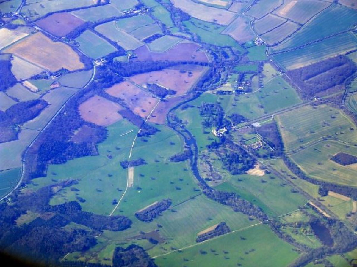
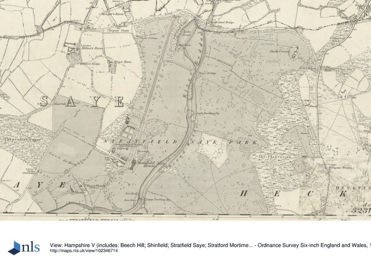
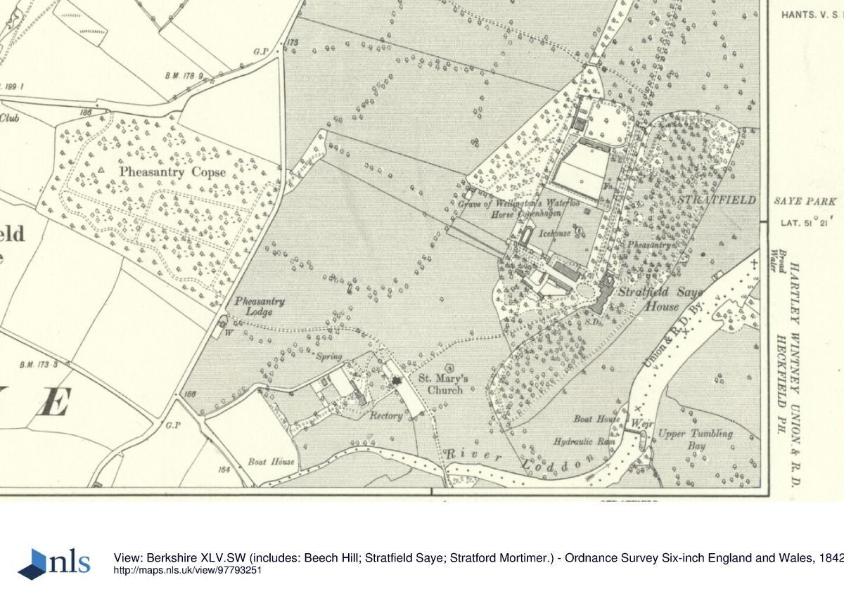
Stratfield Saye Park lies on the west side of the A33, Basingstoke Road, c 1.5km south of Swallowfield and east of the hamlet of Stratfield Saye. The 523ha registered site comprises c 35ha of pleasure grounds and walled gardens and c 488ha of parkland, farmland, and woodland. The whole perimeter of the park is bounded by agricultural fencing and by roads and is largely screened by internal woodland or by tree belts which have been replanted and extended in the 1990s.
The A33 runs along the eastern and southern boundaries while minor lanes abut to the north (Welsh Lane and Chequer Lane) and to the south-west (Broadford Road). The River Loddon flows from south-west to north through roughly the centre of the park, the land on the west side being fairly level but on the east side rising up the undulating slope of a low ridge to a crest on the eastern boundary. The surrounding landscape is one of level mixed farmland with a scatter of copses and settlements and, east of the A33, woodland and the Wellington Country Park.
Entrances and Approaches
There are several entrances to the park, marked by lodges, from which drives run across the park and to the house. The main routes were laid out by Lord Rivers during the second half of the C18. The principal approach to the house, which was formed in the mid C20, enters midway along the western boundary at the two-storey stuccoed Jubilee Lodges. These were built in 1974 and the axial drive which runs 750m south-east to the north-west, entrance front was lined with an avenue of plane trees at the same time.
On the northern boundary, North Drive enters from Chequer Lane at the East and West Reading Lodges. Of these, the western one (early C19, listed grade II as Elm Lodge and formerly as North Lodge) was refurbished and the eastern one added in the late C20. The drive, which follows a straight but undulating course south-south-west to the north-west front, was established as the main approach to the house by 1759 (Taylor) and described by J C Loudon in 1833 as `planted with elms of a broader-leaved kind than the common English elm' (Gardener's Mag). The elms, lost to Dutch elm disease, were replaced by the present limes in 1972.
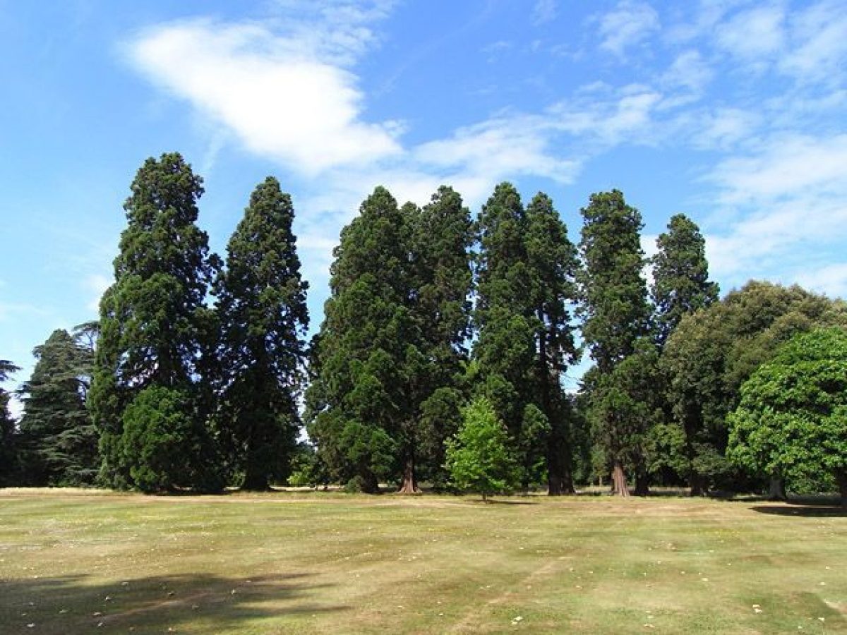
Situated midway along the eastern boundary are Monument Lodges (early C19, listed grade II, formerly known as London Lodges), a pair of symmetrical two-storey stuccoed buildings with slate roofs. In front of these, between their gateway and the road, stands the granite Corinthian column of the Wellington Monument (1866, listed grade II). Immediately inside the park from the lodges, the drive forks to form the two main east to west routes across the park, both of which are shown on the OS map of 1816. One fork leads north-north-west and is lined along its first 350m by a mature avenue of thirty-five pairs of Wellingtonias, planted in the mid 1860s (Gardeners' Chronicle 1896). It then curves north-westwards where, lined with chestnuts planted in 1995, it becomes Main Drive and descends the ridge slope to cross the River Loddon on Stone Bridge and meets North Drive 1km north-north-east of the house.
The other fork of drive (known as Concrete Road) follows a 1.8km south-westerly course across the park before turning north-west to cross the Loddon on an ornamental cast-iron bridge with a parapet of iron railings (listed grade II*), designed and built in 1802 by Thomas Wilson and restored in 1998. Beyond the bridge, this drive continues north-westwards past the church of St Mary the Virgin (listed grade I), built to a Greek cross plan with an octagonal tower and copper dome in 1758, possibly to a design by John Pitt (Colvin 1995). The two-storey brick-built Old Rectory (late C18 or early C19, listed grade II), which stands 70m south-west of the church, may also be to Pitt's design (ibid). The drive leaves the park at Pheasantry Lodge (mid C19, listed grade II) on the western boundary.
Two further entrances are linked to the main routes by short drives. From South Lodge, (identical with North Lodge and listed, with its gate piers, grade II), which stands at the southernmost point of the park, a drive lined with red oak planted in the late C20 runs 350m north to meet Concrete Road; the junction is marked by an immense cedar tree which shades a plinth with a bust of the Great Duke. From the north-west corner, Milton Drive, lined with hornbeam, enters from the lane at Milton Lodge (mid C19, listed grade II) and runs south-east to join North Drive on the north side of the walled gardens.
Principal Building
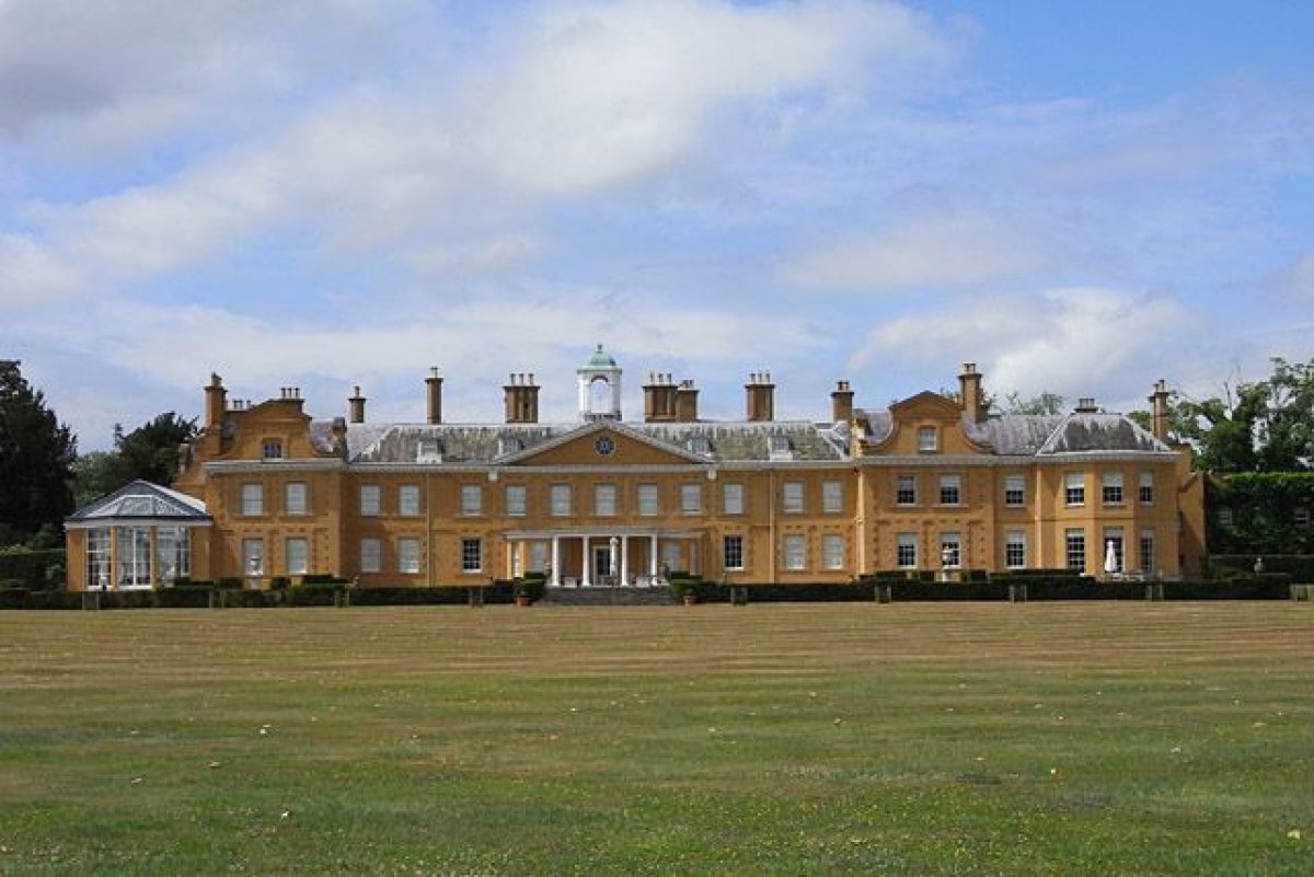
Stratfield Saye (listed grade I) stands west of centre in the park, on level ground overlooking a gentle slope down to the Loddon and with views to the park beyond. The house is of two storeys with an attic and a slate roof and is finished in stucco painted a warm shade of apricot. The central block, which is flanked by inner wings with Dutch gables, was built between 1630 and c 1640 on the site of an existing house and is usually attributed to Sir William Pitt (CL 1948). It was largely remodelled inside by Lord Rivers between 1730 and 1790, the stucco being added to the previous red-brick finish also at this period and the outer wing on the north end of the garden front being built c 1775.
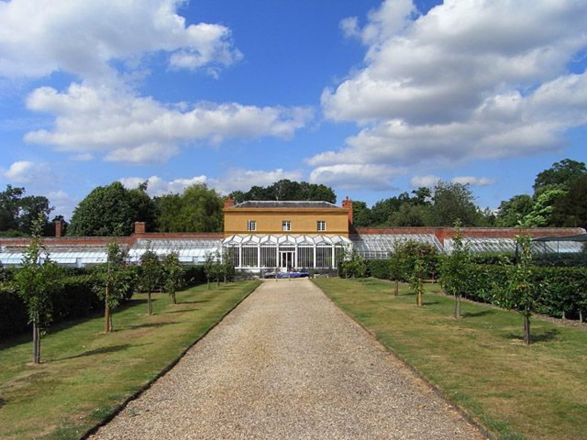
The Great Duke made considerable additions to the house: in 1846, the C18 single-storey outer wings on the entrance front were raised to two storeys (on C18 ground floors) and given matching Dutch gables. The conservatory at the southern end of the garden front was added in 1838, this and the projecting porch of Tuscan style on the entrance front both the work of Benjamin Wyatt.
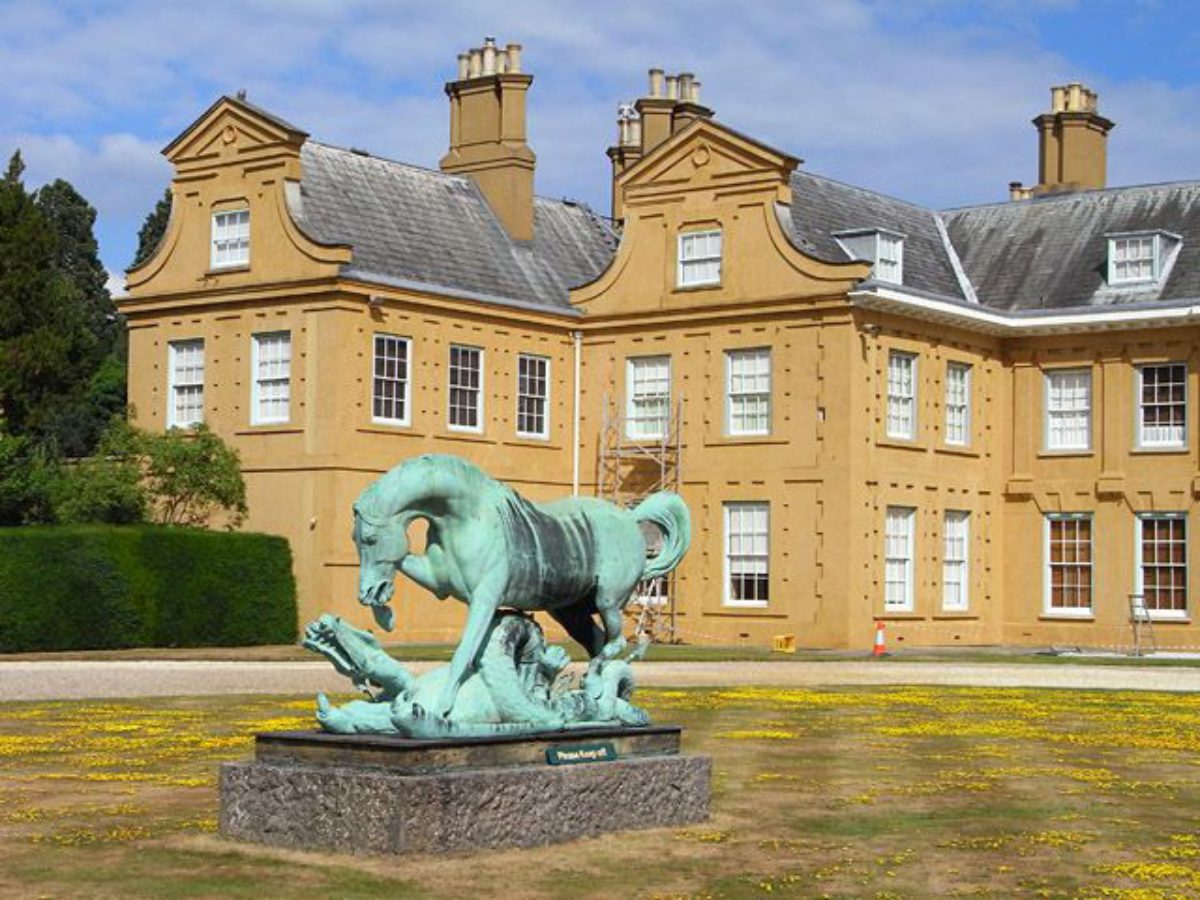
Some 60m north-west of the entrance front, the drive is flanked on either side by a two-storey stuccoed stable range (listed grade II), with pitched slate roofs and with Dutch gables on the east elevations facing the house. These appear contemporary with Pitt's C17 house and were probably connected to its wings by walls to form a forecourt. The centre of the present grassed turning circle in the forecourt contains a statue of a horse and dragon (listed grade II), which forms an early C19 unfinished commission by George IV to Matthew Cotes Wyatt and was brought to Stratfield Saye from Apsley House in 1950.
Gardens and Pleasure Grounds
The formal gardens and pleasure grounds extend either side of the house to north and south. The east, garden front opens onto a grassed and paved terrace from which a central flight of steps leads down onto open lawn sloping gently towards the Loddon. From both the terrace and the lower slopes of the lawn, grassed paths lead into the North and South Pleasure Grounds. These, which are fenced or railed and, on the west side, screened by shrubbery from North Drive, are planted informally with a wealth of both coniferous and deciduous exotic and native broadleaved tree species, of varied ages and including a number of mature Wellingtonias.
Planting in the Pleasure Grounds was begun by the first Lord Rivers in the late C18 but most of the layout is the work of the first Duke of Wellington in the early to mid C19, the enclosure of the North Pleasure Grounds being shown on the OS 1st edition map surveyed c 1870. The South Pleasure Grounds were enclosed by 1909 (OS). Considerable new planting in both has been carried out since 1972. At the north end of the North Pleasure Grounds, some 400m from the house, stands a small rustic summerhouse, designed as a Roman Temple with a double aspect and faced with short sections of unpeeled split branches in a pattern of diagonals. Built in 1846 to commemorate a visit by Queen Victoria, it was restored in 1997.
The formal gardens lie west of North Drive. Immediately north of the northern stable range, and enclosed on the west side by a high brick wall and on the north and east sides by iron railings, are two paddocks, the eastern Ice House Paddock containing a sunken, circular brick-lined icehouse with a domed top (listed grade II). Some 40m north of the icehouse, a headstone marks the grave of Copenhagen, the Duke of Wellington's horse at Waterloo. Northwards, a narrow strip of land between the paddocks and the south side of the kitchen garden wall is laid out as a rose garden with beds interwoven by serpentine grassed paths, while between the east wall of the kitchen garden and the North Drive is the American Garden. This is laid out in a linear series of circular and lozenge-shaped beds centred on a circular fountain basin and planted with trees and shrubs, many of which are native to North America. Both gardens were created by the first Duke in the early to mid C19 and were restored after 1975 (guidebook).
Park
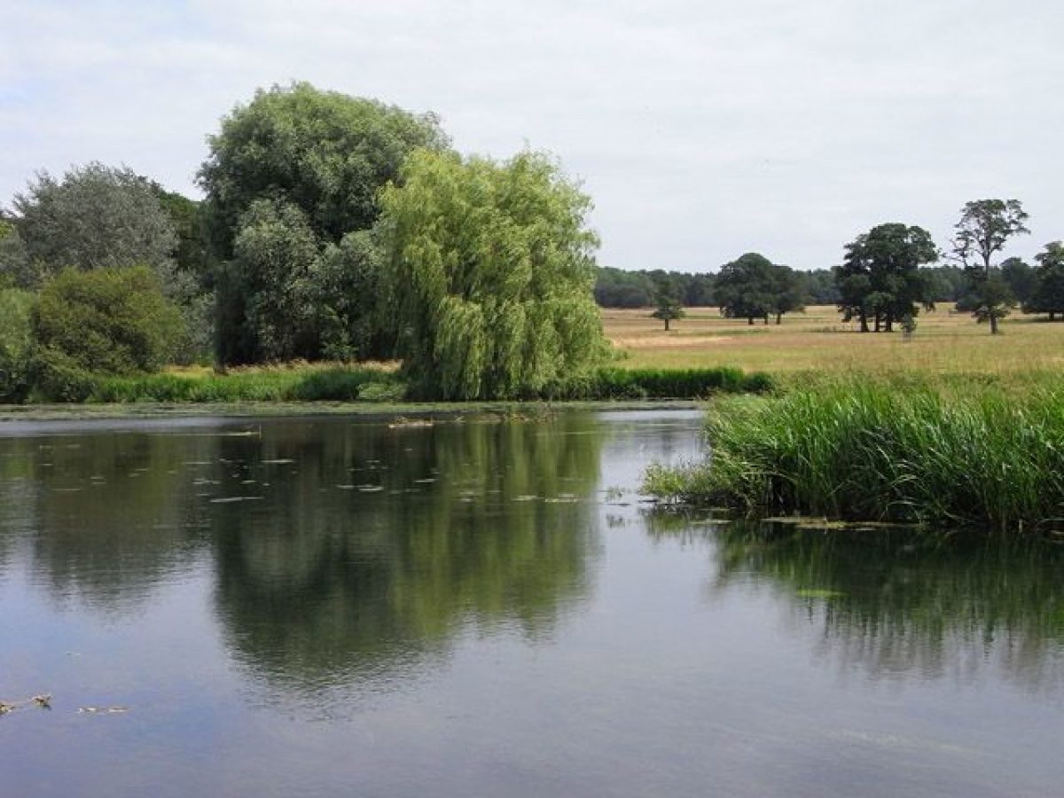
The park surrounds the house and gardens with the main areas planted as parkland lying to the north-east, east, and south-east. The River Loddon follows a gently serpentine course from south to north through the centre of the park; the 1.5km length south of Stone Bridge, which flows past the Pleasure Grounds and is known as the Broad Water, widens out to encompass groups of wooded islands.
North of Stone Bridge, the river feeds a tree-fringed lake. Both the smoothed contours of the Loddon and the construction of the lake and bridges formed part of Lord Rivers' work to reshape its `numberless little meanders' and to give it `the scope and dimensions of a fine river' (Steward's account, c 1810). West of the river, the park is now (1999) largely under arable cultivation with a light scatter of single trees. East of the river, where the rising ridge slopes are riven by little valleys, the parkland is mostly under permanent pasture with occasional clumps and individual trees, of varying ages and species, including a number replanted in the mid to late C20.
Inclosure of a park at Stratfield Saye dates back to 1216 (VCH 1911). By the mid C18 its boundaries encompassed the present park north to Chequer Lane and east to the A33 but did not extend west beyond North Drive and the gardens. Expansion took place in the mid C18 and early C19 under Lord Rivers with the addition of Park Corner and land to the south (Greenwood 1826), the park reaching its present (1999) western extent by 1871 with the realignment west of the western boundary lane.
Towards the eastern and southern site boundaries, parkland is replaced by woodland comprising mixed plantations and copses which are linked by an almost continuous belt around the park's perimeter. Most of the woods were established in the mid to late C18 by Lord Rivers who was a `provident forester' (CL 1948); the little conifer-planted valleys north-west of the London or Monument Lodges are still known (1999) as `Switzerland' owing to their `forcibly remind[ing] the passenger of the romantic Alpine scenery' (Steward's account, 1810).
Several estate cottages and domestic buildings, dating from the C17, C18, and C19, are situated within the woodland: on the southern boundary, Keeper's Cottage and its stables (listed grade II) stand c 100m north-east of South Lodge, with Park Pitham Cottage (listed grade II) 200m further east; fronting the A33 in the south-east corner are Parkside, The Cottage, and Springwell Cottages (all listed grade II) and, 200m south of the Wellington Monument, Goburn's Hill (listed grade II). The Kennels and Kennel Cottage (listed grade II) stand 300m north of the Monument, and in the north corner of the park, the C18 and C19 stucco-fronted Park Corner with its own lodge, Park Corner Lodge (both listed grade II).
Kitchen Garden
The kitchen garden stands c 200m north of the house, on the north side of Ice House Paddock. Laid out in the mid to late C18 to a tapered square in plan, it is enclosed by high red-brick walls and divided into two compartments, each with a central circular water tank, by an east to west wall (walls listed grade II). From an arched entrance in the southern wall, a central axial path runs north through the southern compartment, which is laid to grass, into the northern one which is quartered by paths lined with espaliered fruit and cultivated for fruit and vegetables. The axial path terminates at a glazed Camellia House, said to be designed by Joseph Paxton (guidebook), which is built as an ensemble with a two-storey gardener's house (listed grade II) into the north wall of the garden. Northwards, paddocks and private gardens occupy the site of a former orchard shown on the OS map of 1870.
Maps
- Isaac Taylor, A Map of Hampshire ¿, 1" to 1 mile, 1759
- Thomas Milne, Hampshire or the County of Southampton, 1" to 1 mile, 1791
- C and J Greenwood, A Map of the County of Southampton, 1" to 1 mile, 1826
- OS Old Series 1" to 1 mile, published 1816
- OS 6" to 1 mile:
- 1st edition surveyed c 1870
- 2nd edition published 1897
- 3rd edition published 1913
- OS 25" to 1 mile: 3rd edition published 1909
Illustrations
- Drawings for the rebuilding of Stratfield Saye, early C19 (private collection)
Archival items
- Steward's Account, c 1810 (quoted in CL 1948)
Description written: January 1999 Amended: August 2001
Register Inspector: VCH
Edited: February 2004, March 2022
- Visitor Access, Directions & Contacts
Telephone
+44 (0) 1256 882694Access contact details
Pre-booked Tours Only
14th to 18th April 2022
5th to 29th August 2022
Times of tours – 10.15am, 11.15am, 12.15pm, 1.15pm, 2.15pm and 3.15pm.Visit the Stratfield Saye House and Grounds website for more details.
Directions
The site is one mile west of the A33 between Basingstoke and Reading.
- History
The following is from the Register of Parks and Gardens of Special Historic Interest. For the most up-to-date Register entry, please visit The National Heritage List for England (NHLE):
11th - 13th Century
A manor was formed at Stratfield Saye in the C11 and was owned by the Stotefield family in the C12. It acquired its present name by the marriage of a Stotefield heiress to Robert de Say. William de Say was granted a licence to inclose his wood to form a park in 1216 and by c 1340, a house had been built there (VCH 1911).
14th - 17th Century
In the late C14, the estate passed by marriage to the Dabridgecourt family and remained in their ownership until, in the early C17, their indebtedness to Sir William Pitt enforced conveyance of the estate, in various parcels of land and buildings throughout the 1620s, to the Pitt family.
Sir William Pitt is traditionally credited with the building of the present house, on obtaining final possession of the estate in 1630 (CL 1948). The marriage of his grandson, George, to the daughter of John, Earl Rivers (she was the widow of Lord Chandos of Sudeley), brought the connection with the Rivers peerage to the Pitts of Stratfield Saye and when a descendent, another George, was ennobled in 1776, he took the title Baron Rivers of Sudeley.
18th - 20th Century
Lord Rivers had succeeded to the estate in 1745 and, through the second half of the C18 until his death in 1803, he made major changes and improvements, these being recorded in some detail in an account written by his steward, Mr Brookes, in a manuscript of c 1810 (CL 1948). Lord Rivers removed the `regular terraces and square fishponds with clipped hedges and quaint parterres and felled most of the avenues. The present walled gardens north-west of the house were built and the pleasure grounds planted with an arboretum of exotic trees. The park was greatly enlarged and planted with specimen trees `which gradually recede into open groves thence by a gentle transition into a depth of thick woodland forming a varied and picturesque horizon', while the course of the River Loddon was widened and smoothed.
Following his victory at Waterloo in 1815, the Duke of Wellington purchased the estate in 1817. Probably for financial reasons, none of the various designs for the replacement of the house, prepared by architects such as James Wyatt's eldest son Benjamin Dean Wyatt, and C R Cockerell, were pursued (drawings at Stratfield Saye). The first or Great Duke made a number of additions and alterations to the house, adding the conservatory and the outer wings. Planting in the gardens and park continued throughout the C19 and C20 by the Great Duke and his descendants, the most notable tree species being the Wellingtonia which was first planted at Stratfield Saye by the second Duke in 1854, following its introduction in 1853.
21st Century
The estate remains (2022) in private hands.
- Associated People
- Features & Designations
Designations
The National Heritage List for England: Register of Parks and Gardens
- Reference: GD1863
- Grade: II
Features
- House (featured building)
- Description: Sir William Pitt is traditionally credited with the building of the present house.
- Earliest Date:
- Latest Date:
- Planting
- Description: American garden, recently restored.
- Earliest Date:
- Latest Date:
- Rose Garden
- Description: Rose garden, recently restored.
- Earliest Date:
- Latest Date:
- Specimen Tree
- Description: Wellingtonias.
- Tree Belt
- Description: Tree belts have been replanted and extended in the 1990s.
- River
- Description: The River Loddon flows from south-west to north through roughly the centre of the park.
- Key Information
Type
Estate
Purpose
Ornamental
Principal Building
Domestic / Residential
Survival
Extant
Hectares
523
Open to the public
Yes
Civil Parish
Stratfield Saye
- References
References
- {English Heritage Register of Parks and Gardens of Special Historic Interest}, (Swindon: English Heritage, 2008) [on CD-ROM] Historic England Register of Parks and Gardens of Special Historic Interest
- Pevsner, N. and D. Lloyd, {The Buildings of England: Hampshire and the Isle of Wight} (Harmondsworth: Penguin, 1967), pp. 614-6 The Buildings of England: Hampshire and the Isle of Wight
- Page, W. {Victoria County History: Hampshire and the Isle of Wight, Volume 4} (London: Constable, 1911), pp. 57-61 Victoria County History: Hampshire and the Isle of Wight, Volume 4
- Colvin, H., (1995 edn), p 757 A Biographical Dictionary of British Architects 1600-1840
- James, J, G., (Newcomen Society Paper January 1979) The Cast-iron Bridges of Thomas Wilson 1800-1810
- (19 November 1948), pp 1050-3; (28 November 1948), pp 1106-09 Country Life, 104
- (Stratfield Saye, mid 1990s) Stratfield Saye, guidebook
- (11 January 1896), pp 7-8, 44-5 Gardeners' Chronicle I
- (1833), pp 673-7; (1896), pp 711-13 The Gardener's Magazine