Introduction
Originating in the medieval period, the gardens now lie within the remnants of late-18th/early-19th-century parkland. The park is in divided use and ownership, with parkland and gardens of 10 hectares surviving around the house. The site features an old walled garden planted in the Arts and Crafts style, within a woodland garden.
Terrain
The land is largely low lying and level, with a gentle slope north-westwards from the hillock on which the church stands at the south corner of the park.
The following is from the Register of Parks and Gardens of Special Historic Interest. For the most up-to-date Register entry, please visit The National Heritage List for England (NHLE):
A 17th century and later country house with gardens and pleasure grounds, surrounded by a landscape park laid out in the 18th century.
Location, Area, Boundaries, Landform and Setting
Swallowfield Park lies 8km south of the centre of Reading, adjacent to the east edge of the village of Swallowfield. The 135ha site is bounded to the south-west by Church Road, to the north largely by the River Loddon and connecting drains, and on the other sides by agricultural land. The land is largely low lying and level, with a gentle slope north-westwards from the hillock on which the church stands at the south corner of the park. The setting is largely agricultural and wooded, with the village of Swallowfield to the south-west and Spencer's Wood village to the north-west.
Entrances and Approaches
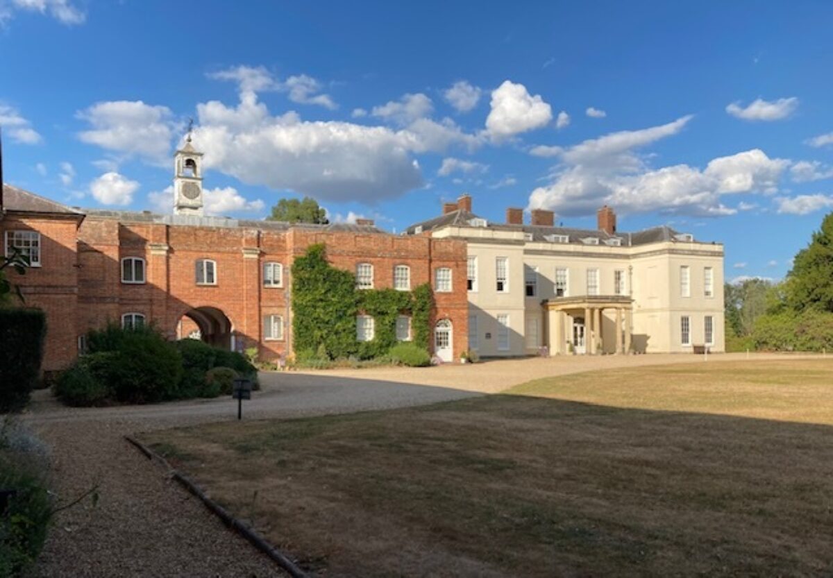
The main south-west drive enters off Church Road, close to the centre of Swallowfield village, 650m south-west of the house. Formerly the drive entered at Red Lodge (C19, listed grade II), lying 50m west of this entrance, a two-storey brick lodge built in Muscular Gothic style, the entrance being flanked by octagonal brick piers and curved, pierced brick walls (C19, listed grade II). The drive runs north-east to the Blackwater River, which extends north-west through the park from the south corner, the drive being carried across the water by a five-arched brick bridge (listed grade II) built for `Diamond' Pitt by John James in 1722. Continuing north through the park, the drive passes east of the dovecote (C17/C18, listed grade II), an octagonal brick tower surrounded by a mid C19 open cow shed standing in a brick enclosure, continuing alongside the west side of the stables (C17 and later, listed grade II* with the house).
The drive passes through the two-storey, brick-built stables via a central archway, emerging into the gravel forecourt on the south front of the house. A porte-cochère (William Atkinson 1820s) encloses the central entrance to the house, overlooking the adjacent carriage sweep, with beyond this the south lawn, planted with mature specimen trees including cedars of Lebanon, and beyond this the park. An archway at the west end of the south front leads into a service court enclosed by service buildings except on the west side which is bounded by a low brick wall and overlooks the Yew Walk to the Talman Doorway into the walled garden.
The south-east drive, now a farm track, enters 800m south of the house, off Church Road, adjacent to the east bank of the Blackwater River, past a former lodge (rebuilt C20). The drive curves around the hillock on which the church sits within the churchyard, 700m south of the house, curving north through the park, overlooking the Blackwater to the west, to arrive at the carriage sweep on the south front. The former east drive (gone, 1998) entered 1km east of the house, past the former Park Lodge (gone, 1998), before curving south-west and west across the eastern half of the park, joining the south-east drive 200m south of the house.
Principal Building
Swallowfield Park (1689-91 and later, William Talman and others, listed grade II*) stands towards the centre of the park, raised on a terrace adjacent to the north and east fronts. A house has stood on this site since at least the Middle Ages, William Talman building the present two-storey brick building (rendered in the C19) for the second Lord Clarendon, together with the adjacent stables and service court. The house was subsequently much altered, possibly having been entered from the north side when built. In the 1820s Talman's impressive entrance doorcase was removed to the entrance to the walled garden (listed building description). The two-storey stables (Talman 1690s, listed grade II* with the house) extend south from the service court to form the west side of the forecourt on the south front of the house.
Gardens and Pleasure Grounds
The gardens and pleasure grounds surround the house, extending west around the walled garden and north in a narrow neck to the River Loddon.
A central door in the north front opens into a small, paved courtyard (laid out late C20) which leads to a raised grass terrace running along the north front and extending south along the east front. A gravel path runs along the top of the terrace, overlooking the informal east and north lawns planted with a variety of mature specimen trees. The south end of the east arm terminates at the forecourt by the south front of the house, whilst the north end of this arm is terminated by a flight of stone steps leading down to a gravel path extending 150m north to a large London plane.
The west end of the north arm is marked by a further flight of stone steps leading down to a cross path from the service court to the south, giving access to the pleasure grounds to the north. Steps lead west down from the path to a walk set in lawn flanked by mature trees, overlooking the park, which encloses the walled garden and returns to the service court on the west front of the house. A pets' cemetery, in which Bumble, a dog belonging to Charles Dickens is buried, lies along this walk, adjacent to the north wall. The walk continues around the outer side of the west wall past the bothies, returning east along the outer side of the south wall along Orchard Walk.
From the steps at the west end of the north terrace the cross path leads north along the west side of the north lawn, flanked by mature specimen trees including Indian bean trees, an Austrian pine and a cork oak. The path enters the narrow neck of the pleasure grounds separating the west park from the east park, leading first north-west, past the former Decoy Pond, then turning north-east 300m north of the house, flanked by mature trees including yews and limes. Some 500m north of the house the path runs along the bank of the Loddon for 150m, terminating at the west corner of Great Wood, with the silted-up remains of a former pool lying parallel to the east. Formerly (OS 1877, 1913) it appears that a path continued across a footbridge into Great Wood where it joined a network of paths running principally south to the southern edge of the Wood.
In the mid C18 (Rocque, 1761) a network of formal avenues in patte d'oie form radiated from a circular feature centred on the south front of the house, the principal avenue being aligned to the north on the south front, and to the south on the present (1998) site of the bridge, although no bridge is depicted by Rocque. North of the house a pond lay in the centre of what is now the north lawn, with what may have been the Decoy Pond to the west and a walk north from its north end to the Loddon. By the 1790s (Pride, 1790) the formal arrangement to the south had gone, and by the early C19 (estate map, 1809) the pleasure grounds had appeared, running north from the north lawn and referred to as `grove'.
Park
The park encloses the house and pleasure grounds which divide it into west and east halves. The majority is now laid to arable, except for the areas west of the Decoy Pond, and south of the house flanked by the south-east and south-west drives, which are laid to pasture and also contain many specimen park trees. The park is low lying and inclined to flood. An icehouse (listed grade II) lies 400m south of the house in the east park. The north-east side of the east park is bounded by Great Wood.
By the 1760s (Rocque, 1761) Swallowfield Park existed as a landscape park occupying the southern half of the present east park, extending south to the Farley Hill lane. This park was divided from the formal garden to the west by a straight canal running north from the Blackwater River close to the church, connecting it with the Loddon at the north end of the riverside walk. By 1790 (Pride) the whole of the present park had been landscaped, with the canal still bisecting it. The 1809 map shows the park west of the canal crossed by a network of lesser canals or drainage ditches and other functional water features, presumably designed to drain the water meadows, these features having been removed in the 1850s.
Kitchen Garden
The 1.5ha, brick-walled kitchen garden lies 100m west of the house, enclosed by the ornamental garden walk. It is approached via an iron gate in the low, brick west wall of the service court which gives onto a gravel path flanked by clipped Irish yews, the Yew Walk. The Walk, aligned eastwards on the passage in the house connecting the main hall with the service court, extends 75m west, flanked by lawn, to the east wall of the garden, in which is set Talman's doorway enclosing a garden gate (C17 and later, listed grade II, restored 1998). The doorway, ornamented with pilasters with garlands and surmounted by a broken segmental pediment with swags and drapes, appears to have been moved from the main entrance to the house c 1820s and set into walls built by Thomas Pitt in the 1720s.
The eastern third of the garden is planted with mature trees and shrubs, the western two-thirds being laid to lawn with borders and specimen fruit and other trees. These two sections are separated by the remains of a yew hedge running from south to north across the garden, and connected by a central path which runs east to west. The gardener's cottage (C19) straddles the west wall towards the south end. Several doorways lead to the exterior garden walk. Formerly (OS 1911) a range of glasshouses stood against the inner side of the west wall, flanked by two free-standing glasshouses, these all now gone. A range of derelict C19 bothies stands against the outer side of the west wall.
John Evelyn refers to nurseries, orangeries and a kitchen garden in 1685, but it is not possible to relate this description to the walled garden present today. It seems that Pitt built the majority of the walls in the 1720s, the area being by the 1760s (Rocque, 1761) divided into six quarters with a central east/west path. Sir George Russell rebuilt the west end c 1885, widening it to north and south and building the gardener's cottage.
Maps
- J Rocque, Map of Berkshire, 1761
- T Pride, A topographical map of the Town of Reading and the County adjacent to an extent of 10 miles, 1790
- Map of an Estate ... in the Parishes of Arborfield and Swallowfield belonging to T H Earle, 1809 (Berkshire Record Office)
- Tithe map for Swallowfield parish, 1840 (Berkshire Record Office)
- Plan of the Swallowhill Estate, the Property of Sir Charles Russell, 1872 (Berkshire Record Office)
- OS 6" to 1 mile: 1st edition surveyed 1871-72, published 1877
- 2nd edition revised 1913
- OS 25" to 1 mile: 2nd edition published 1911
Description written: September 1998
Amended: September 1999
Edited: April 2000
- Visitor Access, Directions & Contacts
Access contact details
Swallowfield is not open to the public.
Directions
5 miles south of Reading
- History
The following is from the Register of Parks and Gardens of Special Historic Interest. For the most up-to-date Register entry, please visit The National Heritage List for England (NHLE):
14th - 17th Century
Swallowfield Park was enclosed by Edward III in 1354, remaining in royal ownership until the 16th century. The estate was acquired in the late 16th century by Samuel Backhouse (d 1626), passing through his family during the 17th century, and passing by marriage into the hands of Henry Hyde (d 1709) shortly before he became second Earl of Clarendon in 1674.
In 1685 Lady Clarendon (d 1700) was accompanied to Swallowfield by John Evelyn who wrote an account of the estate in his diary for 22 October 1685, describing the features and plants he found, 'the gardens and waters as elegant as `tis possible to make a flat [site] by art and industry and no mean experience ... the nurseries, kitchen garden full of the most desirable plants, two very noble Orangeries well furnished, but above all the canal and fishponds'.
The second Earl rebuilt the house 1689-1691, the designs being those of William Talman, Comptroller of the King's Works. Edward Hyde, the third Earl, sold the estate some time before 1718 to the nabob Thomas Pitt, late Governor of Madras, known as 'Diamond Pitt', who bought the estate with part of the proceeds of selling the Pitt or Regent diamond, and died there in 1726. Pitt employed John James to alter the house, and it is also thought that James designed the bridge in the park (Inspector's Report 1990).
18th Century
The estate was sold out of the Pitt family in 1737, passing through various families during the remainder of the 18th century, and being sold to Sir Henry Russell, first Baronet in 1820. The formal landscape of rides present to the south of the house in the 1760s (Rocque, 1761), laid out in patte d'oie form, had disappeared by the 1790s (Pride, 1790), by which time the park had been entirely landscaped.
19th Century
In the early 19th century (estate map, 1809) the estate was crossed by a network of ponds and canals, these being removed in the 1850s.
20th Century
The estate remained in the Russell family until 1965 when it was divided up and sold, the house and stables being converted into residential apartments for the Country Houses Association.
21st Century
In 2003 the mansion was acquired by property developers, Sunley Heritage, and converted into self-contained apartments (2022).
Period
- 18th Century (1701 to 1800)
- Late 18th Century (1767 to 1800)
- Associated People
- Features & Designations
Designations
The National Heritage List for England: Register of Parks and Gardens
- Reference: GD1520
- Grade: II
Features
- Yew Walk
- House (featured building)
- Earliest Date:
- Latest Date:
- Stable Block
- Description: The stables have been converted into residential apartments for the Country Houses Association.
- River
- Description: River Loddon.
- Key Information
Type
Park
Purpose
Ornamental
Principal Building
Domestic / Residential
Period
18th Century (1701 to 1800)
Survival
Extant
Hectares
135
Civil Parish
Swallowfield
- References
References
- {English Heritage Register of Parks and Gardens of Special Historic Interest} (Swindon: English Heritage 2008) [on CD-ROM] Historic England Register of Parks and Gardens of Special Historic Interest
- Pevsner, N. {The Buildings of England: Berkshire} (Harmondsworth: Penguin, 1966) pp238-239 The Buildings of England: Berkshire
- Page, W and Ditchfield, P.H. {Victoria County History: Berkshire, Volume 3} (Victoria County History, 1923) Victoria County History: Berkshire, Volume 3
- Lady Constance Russell, (1901) Swallowfield and its Owners
- Ditchfield, P.H, and Page W., (London, 1923) Victoria History of the County of Berkshire 3
- Country Houses Association, (1990s) Swallowfield Park, A Brief History, guidebook