Introduction
Prior Park is a landscaped pleasure grounds and park, laid out from 1734 on by Ralph Allen with advice from Pope to 1743. There are terraced balustraded steps by Goodridge, dating from 1834. These replaced terraces by Allen and Pope. Other features include a Palladian bridge, two gate lodges and a grotto.
Terrain
Prior Park is situated on the edge of Combe Down, a sandstone ridge that runs east/west, about 2 kilometres south of Bath.
The following is from the Register of Parks and Gardens of Special Historic Interest. For the most up-to-date Register entry, please visit The National Heritage List for England (NHLE):
Landscape park, laid out in C18 with advice from Alexander Pope and Lancelot Brown, around a country house.
Location, Area, Boundaries, Landform and Setting
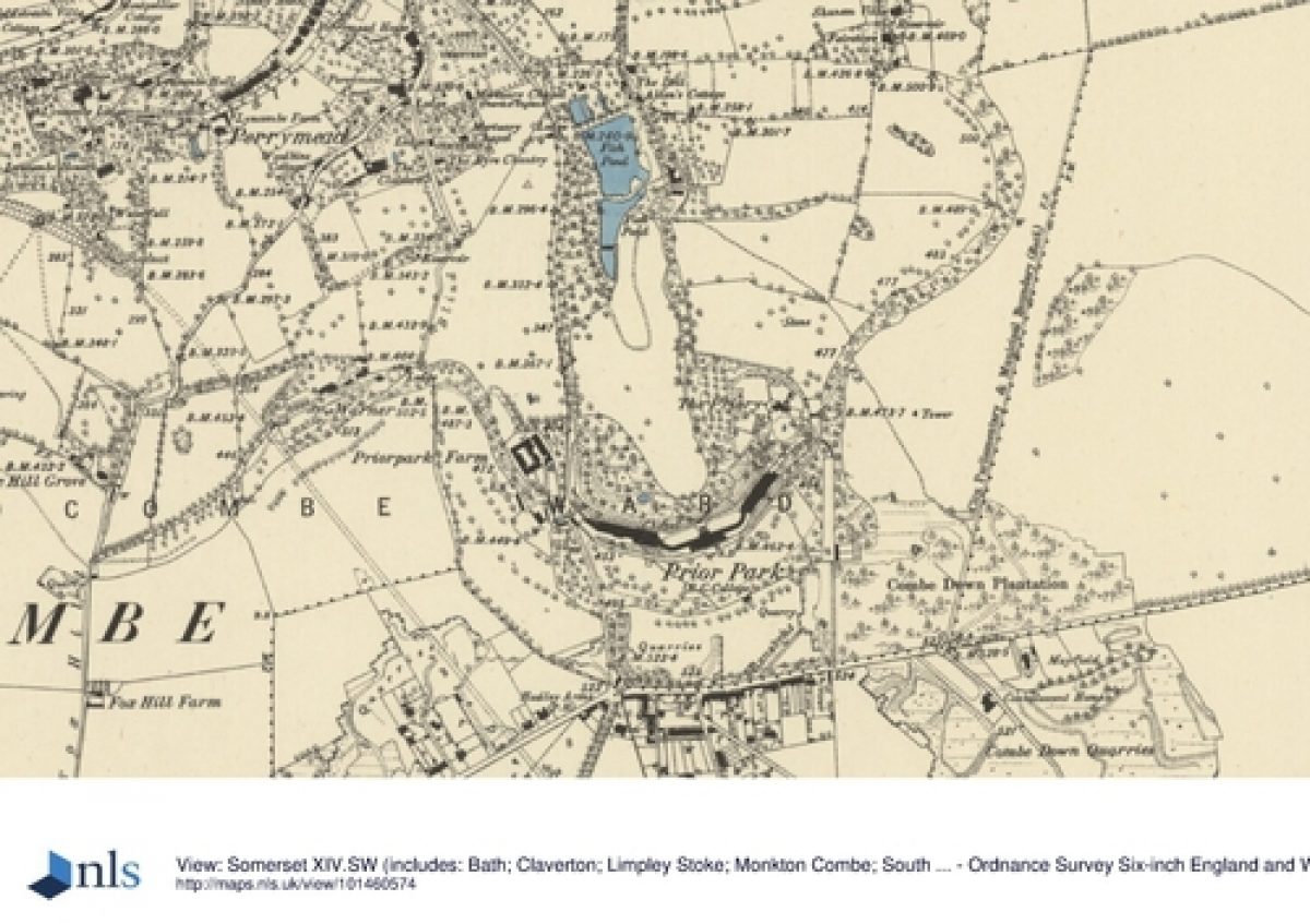
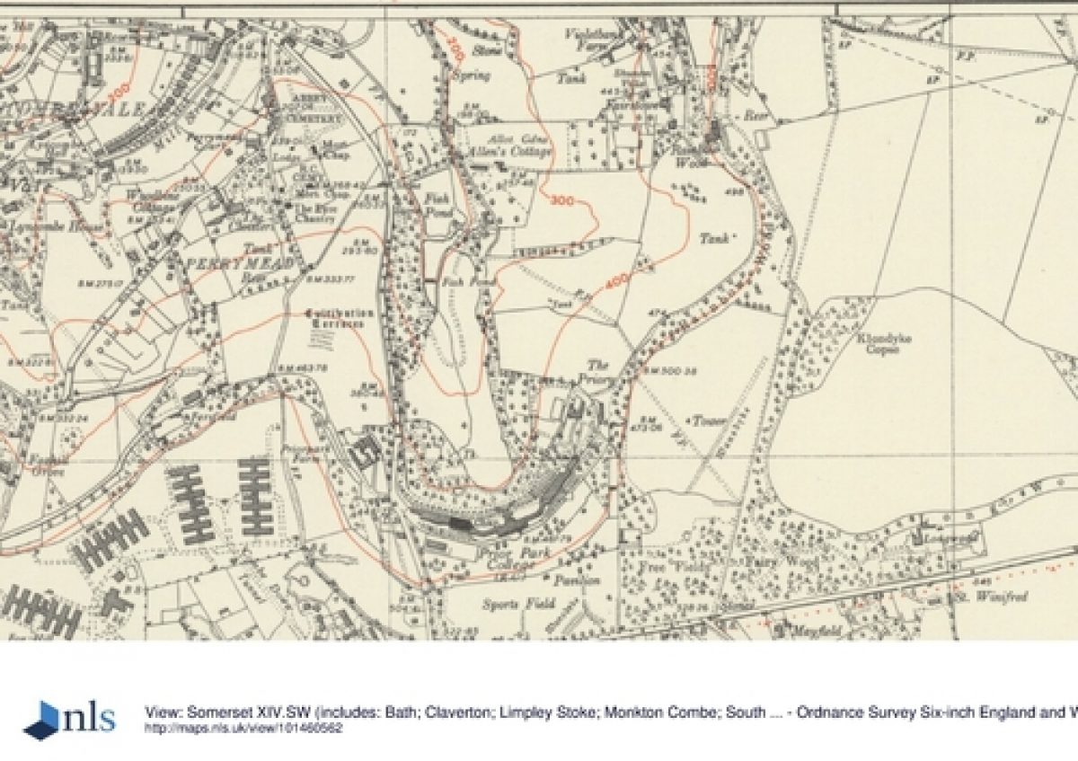
Prior Park is situated on the edge of Combe Down, a sandstone ridge that runs east/west, c 2km south of Bath. The house is located prominently, designed both to see and be seen from the city. The surviving historic landscape comprises some 22ha, and is divided between former parkland, now playing fields, to the south of the house, and the steeply sloping combe to the north, which runs down from the house to three fishponds in Widcombe at the northern extremity of the landscape.
To the west the park is bounded by Ralph Allen Drive, a public highway, formerly a private carriage drive to the house, with a wall c 1.5m high. To the south it is bounded by a stone wall c 4.5m high along the A3062. The eastern boundary follows the edge of the Free Fields, around the north side of The Priory, then follows the edge of the flanking woods of the combe northwards to the north end of the ponds.
Few trees survive of Allen's extensive planting of pines over the neighbouring downs. The ridings he laid out around his extensive holdings on Combe Down totalled some 10 miles (c 16km) in length, but only a few fragments have survived C20 building development. A rustic bridge 250m south-west of the house, which stands over the lane now known as Pope's Walk, used to carry one such drive west from the house. Some 2km to the north-east, Sham Castle (1762, listed grade II*) was built as an eyecatcher from Allen's town house in Bath.
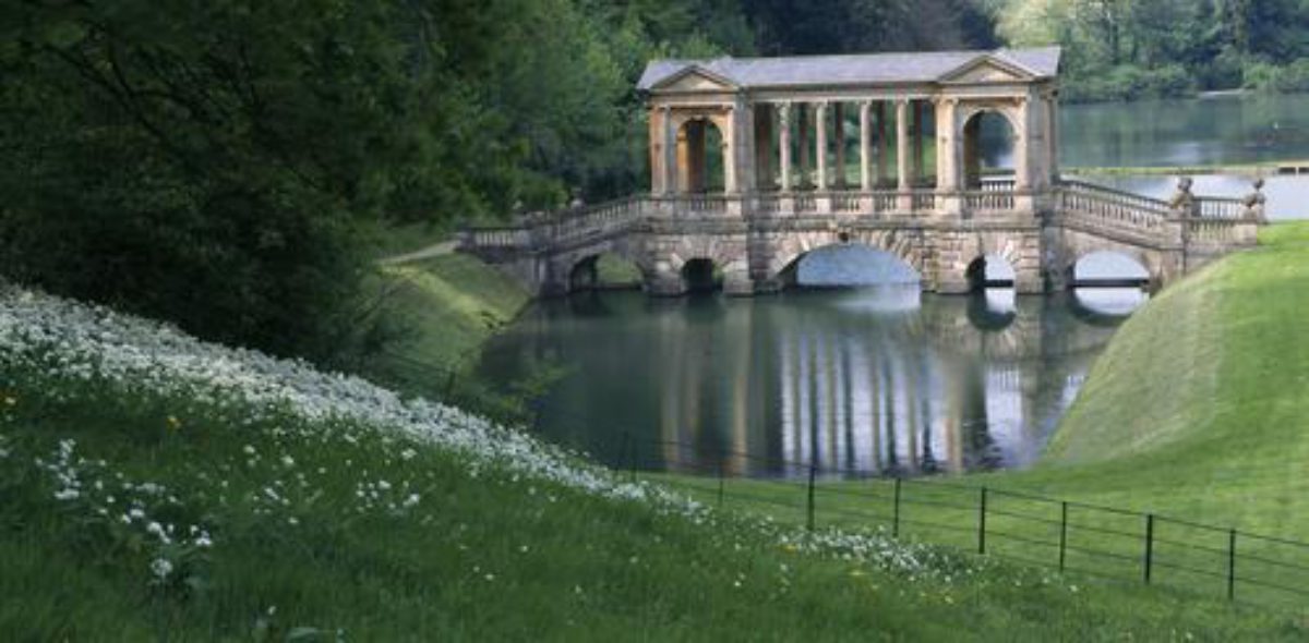
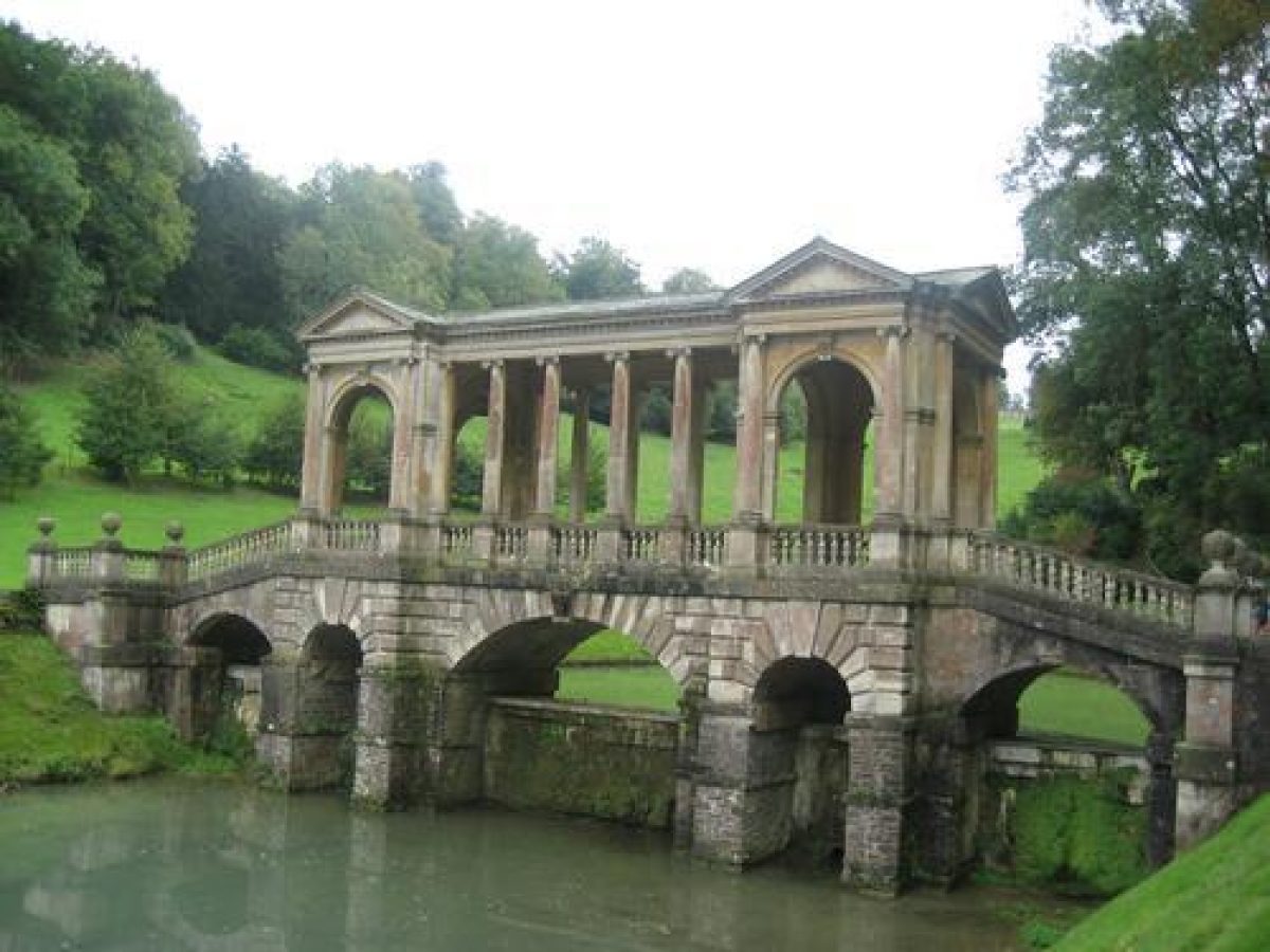
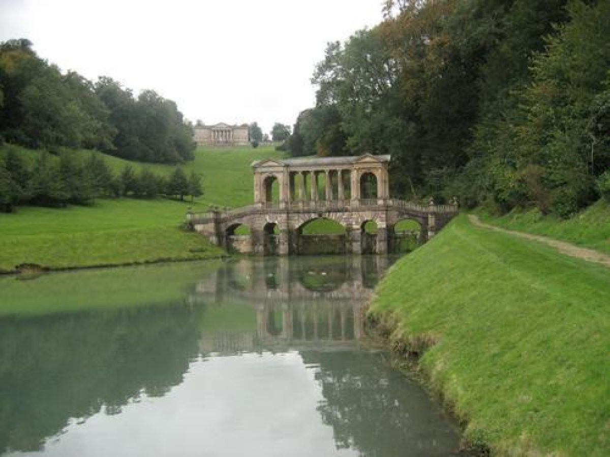
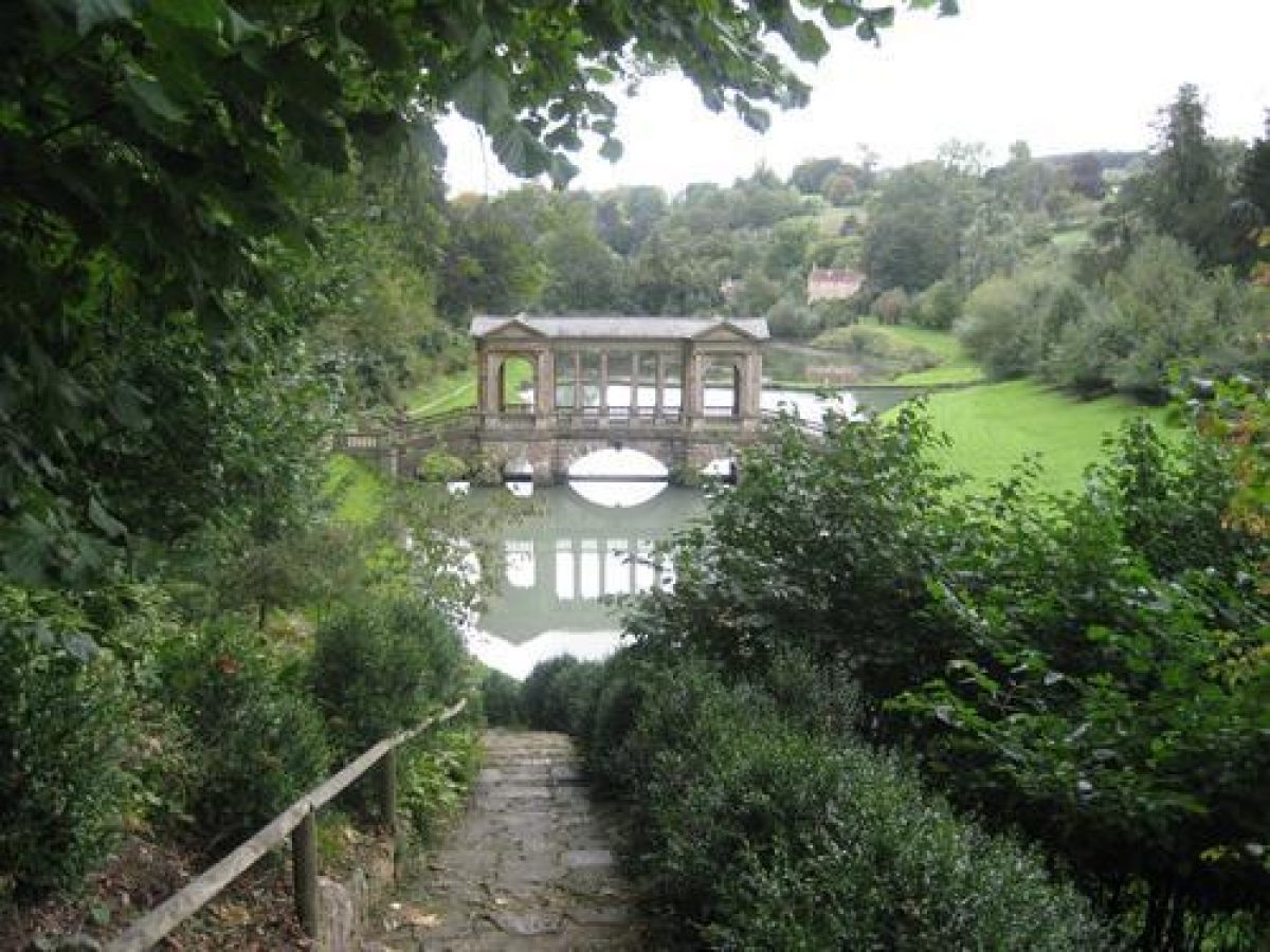
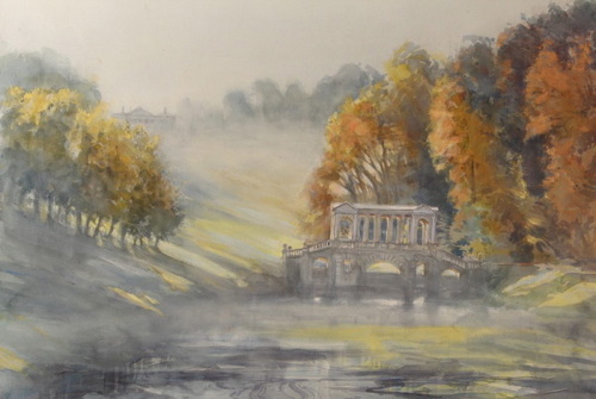
The setting is dominated by the unspoilt view between the flanking woods to the Palladian Bridge and north over Bath.
Entrances and Approaches
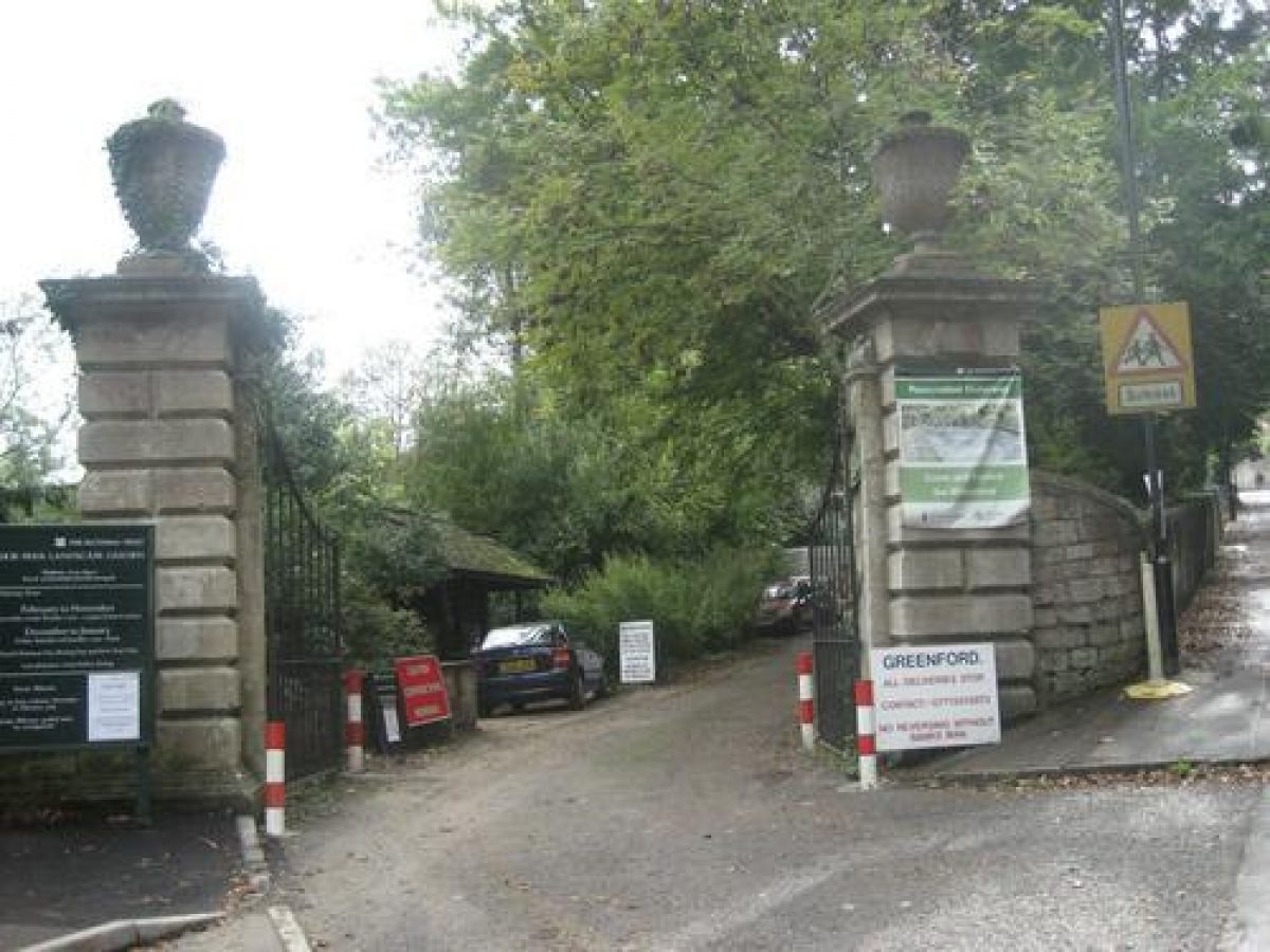
The main approach runs c 100m eastward from the southern end of Ralph Allen Drive, past a lodge designed by Wood the Elder (listed grade II) and through two stone gate piers topped with ornamental carved finials (C18, listed grade II), to the north front of the house.
Some 600m north-north-west, at the junction of Ralph Allen Drive and Church Street in Widcombe (outside the area here registered), is a second lodge by Wood (pre 1742, listed grade II) and gate piers (C18, listed grade II), which related to Ralph Allen Drive before it was made a public highway. By 1759, a new approach had been brought from Ralph Allen Drive, roughly halfway between these two lodges, that led via the Rock or Chinese Gate, southwards round the south side of the ponds, still clearly visible, then via a hairpin bend northwards up to the house along the eastern side of the combe. This was probably constructed by Richard Jones, as a means of bringing stone down to the ponds for the construction of the Palladian Bridge.
The principal National Trust approach enters the grounds 200m north-west of the house via gate piers (1830s, listed grade II). The drive was constructed in the 1830s for Bishop Baines and leads to the front of the house, although a gate 10m south of the grotto now separates the school property from the National Trust land.
Principal Building
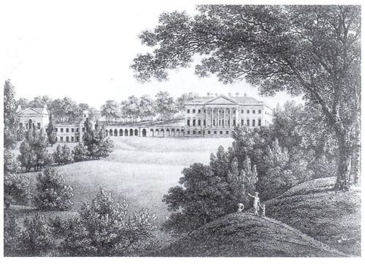
The house at Prior Park was built 1735-43 for Ralph Allen, to designs by John Wood the Elder. It is located at the southern end of a steep combe leading down and north to the village of Widcombe. The house is constructed of Bath stone ashlar with a slate roof and is composed of a central corps de logis, connected by two curving galleries to a west and east pavilion. According to Pevsner (1958), it comprises 'the most ambitious and the most complete re-creation of Palladio's villas on English soil'. Under Wood, only the eastern part was completed and the finishing of the house was left to Richard Jones. A massive central staircase from the north door to the drive dates from c 1836 when it was built for Bishop Baines to designs by H E Goodridge, who also carried out other alterations to the structure of the mansion. In the west range is the church of St Paul (1844, listed grade I), designed by Joseph Scoles (1798-1863). On the south side of the playing fields, 250m south of the house is the Gymnasium (c 1830-40, listed grade II*). In 1991, the house suffered a second major fire; it was restored by the college in 1995.
Gardens and Pleasure Grounds
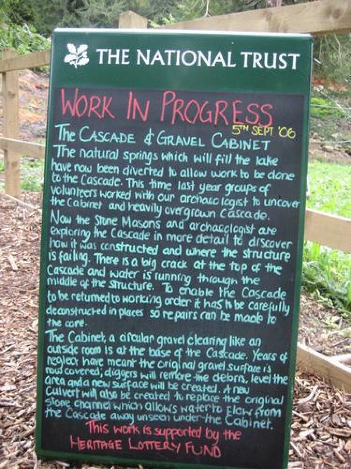
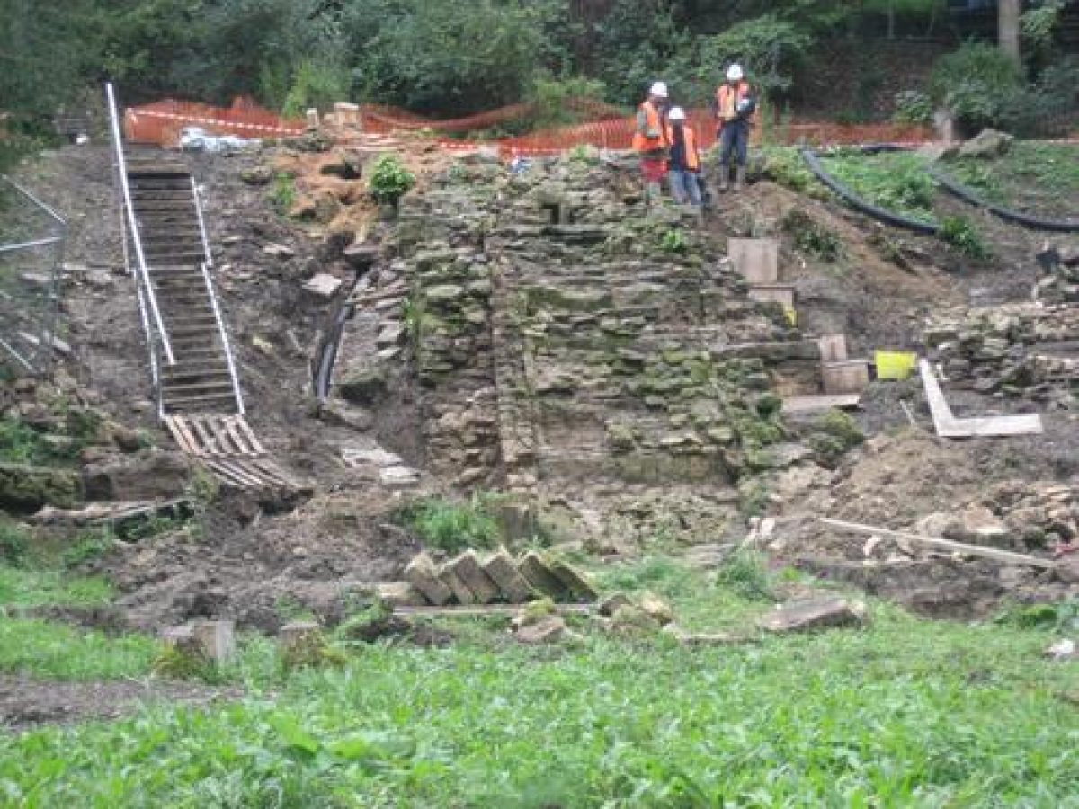
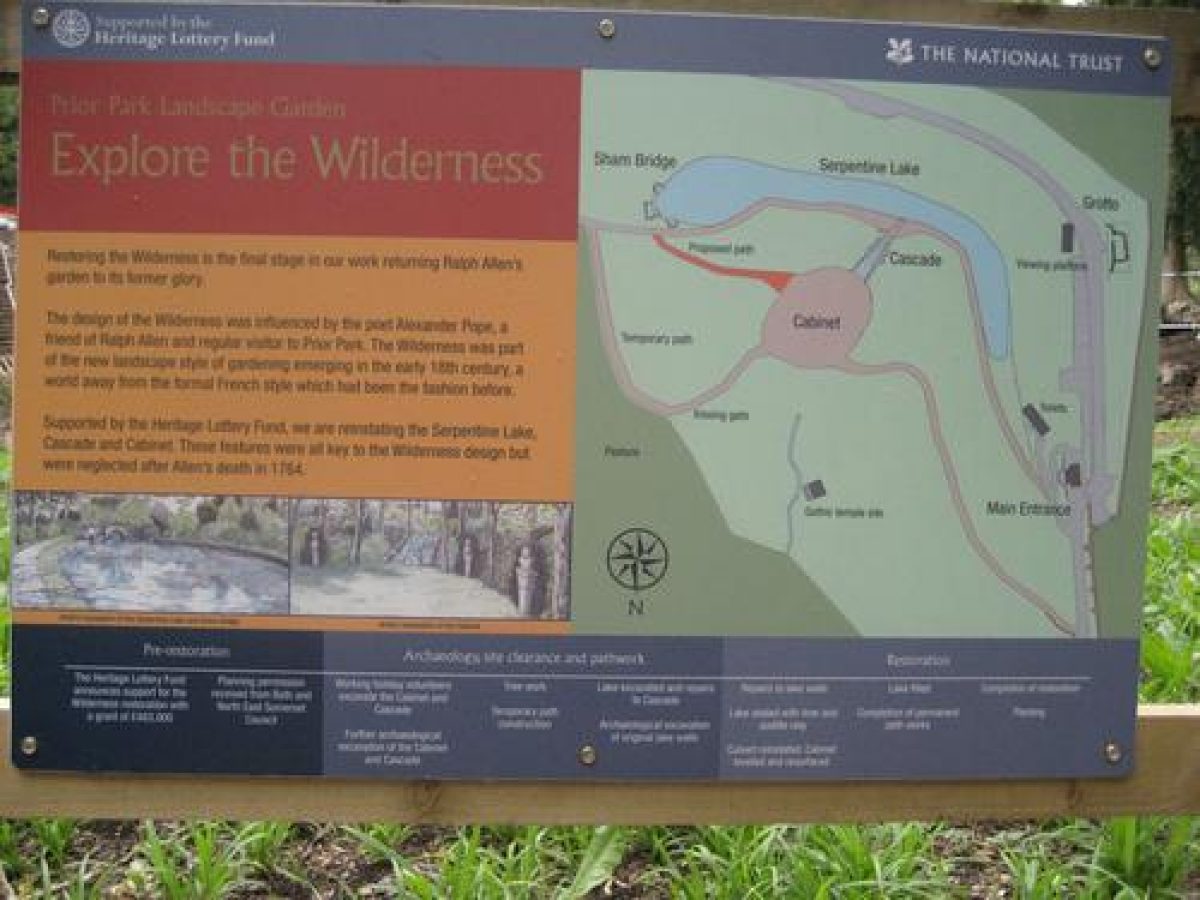
A woodland garden, formerly the Wilderness, developed 1734-40 as the first phase of Allen's landscape garden, lies 200m north-west of the house. In the south of this area is the Sham Bridge (1730s-40s, listed grade II), a stone-built structure by a circular pond 100m north-west of the house, which is all that remains of the Serpentine Lake. This originally ran along the contours westward from the pond but proved structurally unsound; it was filled in in the mid C19, probably after the new approach was constructed in 1836. The terrace on which this was constructed is clearly visible, and halfway along it an outflow feeds the Cascade which descends north into an area of woodland with some notable eighteenth-century yews, formerly a cabinet vert in the Wilderness, before being culverted to run to the top of the central cascade in the main vista.
East of this area are the foundations of a gothic temple built c 1754, but demolished in 1921 and rebuilt in the grounds of Rainbow Wood House 800m north-east of the house. On the west side of the Wilderness, some 100m south of the entrance are the remains of Mrs Allen's grotto (listed grade II), inspired by Pope's grotto at Twickenham (qv Pope's Garden, Greater London), and constructed in the early 1740s. The grotto, which was cut off from the rest of the Wilderness by Bishop Baines's approach constructed in 1836, is in a ruinous condition; of the three tufa arches in its façade one remains, together with the rear retaining wall. It contained the remains of a favourite dog, given to the Allens by Pope and memorialised with an epitaph on a slab on the floor.
East of the Sham Bridge, the National Trust footpath follows the contours into an open combe north of and below the house, along an early C21 fence separating mown lawn on the school side from rougher grazing in the Trust property. By a group of C18 yews, this path turns northwards down the eastern woodland, which is bounded by a wall and ha-ha on its eastern side; a similar belt of yews marks the northern end of this woodland south-east of the dam between the middle and northern ponds. An open-sided Arts and Crafts-style summerhouse, constructed 1910, is situated c 180m north of the house, and remnants of a Victorian rock garden exist west of The Priory, a gothic house designed by Richard Jones for the head gardener in 1740 (listed grade II*). The Jubilee Walk, a short circuit walk constructed by the National Trust, loops eastwards off the main path through the boundary wall onto the open downland to the east.
The Palladian Bridge (c 1755, listed grade I) crosses the dam between the southern and middle lakes 500m north of the house, with a cascade beneath it. This formed the centrepiece of the second phase of works in the 1750s, after Wood's employment had ended in 1748. There are three linked ponds in the combe, the northernmost c 600m north of the house, immediately to the north of which is the site of the former Gibbs Mill and millpond, which were removed in 1840. A circular icehouse (built by 1781, listed grade II) is situated 10m to the west of the Bridge. A flight of steps, introduced by the National Trust, leads down from the mid C18 drive on the west side to the Bridge, which does not appear to have been on a pedestrian or carriage circuit in the C18. A footpath leads back along the western boundary from a Chinese Gate just inside the western boundary to the 1836 entrance and the National Trust car park.
Park
The former parkland to the south of the house is now used as playing fields by the college; tennis courts, hockey pitches, and a cricket square have been levelled here. At the top of the sharp slope that rises southward from the house, there are remnants of C19 tree planting, including horse chestnut, beech, oak, and lime. Sixty head of deer are recorded as stock in the park here and eastward at the time of Allen's death in 1764, and these seem to have been enclosed in the park to the south of the house. A medieval hunting lodge stood on Lodge Field to the east of the house until it was demolished in 1953. Traces of the medieval boundary walls appear to survive along Pope's Lane and below Rainbow Wood; the boundary as a whole is well defined along roads and existing field boundaries.
The present appearance of the combe north of the house owes much to the third phase in the C18 development of the landscape. Allen employed Lancelot Brown, who advised removing the central cascade and creating the dramatic sweep of grassland down the combe, overlooking the Bridge and the city beyond, flanked by informal planting. The National Trust has reintroduced grazing of the slopes between the school boundary to the south and their late C20 fence around the ponds.
Kitchen Garden
No kitchen garden now survives; Allen's was built to the west of the house across Ralph Allen Drive, subsequently developed as Prior Park Farm.
Additional information
The main visual impact of Prior Park derives from its natural situation. The house, a huge Palladian mansion, with its accompanying arcades, offices and pavilions, stretches for 1000 feet across the upper level of the ground, and looks north over Widcombe Vale towards the City of Bath. The garden is designed to take advantage of this position, and woodlands have been created on either side of the valley, leaving the centre open. The fishponds at the bottom of the valley are graced by a Palladian bridge, which acts as a focus for the eye. In the 18th century tradition, the sights around Bath are an integral feature of the view, and there is no sense of detachment between the estate and the surrounding landscape.
The woods immediately to the north-west of the house conceal the serpentine walk with the Sham Bridge and Pope's Grotto. The Priory (originally the Gardener's house) is situated in the woods to the north-east and the gymnasium in Rainbow Woods to the south-east.
The entrances to the site are from Ralph Allen Drive, from North Road or via the footpaths from Widcombe across National Trust land to the north-east. There are also several minor points of access.
Despite many alterations and changes over the years, Prior Park retains the elegance, grace and tranquillity that made it famous in the 18th century.
Although some of the central features of the estate at Prior Park have survived, the historic garden is generally in a state of neglect. The woodland around the main house, and on the east and west slopes of the estate, need much attention, as does the open grassland between the house and the Palladian Bridge. Some of the garden buildings are still used, and are kept in a good state of repair, but others are decaying and crumbling. Several important garden buildings have been moved or demolished over time.
Restoration
Some piecemeal restoration work has been started at Prior Park. Many trees have recently been planted by Avon Environmental Improvements, and a Manpower Services team has uncovered several stone culverts that were once a functional part of the garden. However, Prior Park is a large estate of great historical significance, and if it is to be restored to its former glory it will require an overall management scheme. This will necessitate sufficient resources to carry out an integrated plan that will re-establish harmony between the buildings and the landscape.
Maps
- Survey of Widcombe, 1741 (Bath City Record Office)
- T Thorpe, An Actual Survey of the City of Bath and Five Miles Around, 1742 (Bath City Record Office)
- T Thorpe and J Overton, Survey of the Manours of Bathampton, Clavertion and Widcombe belonging to Ralph Allen Esq, c 1761 (28/854), (Bath City Record Office)
- OS 6" to 1 mile:
- 1st edition published 1887
- 1933 edition
Illustrations
- A Walker, engraving, View of Prior Park, 1752 (Bath Central Library)
- L Sullivan, pen and wash view, early 1750s (Victoria Art Gallery)
- T Robins, 14 drawings of Prior Park and surrounding area, late 1750s - mid 1760s (Courtauld Institute)
- S H Grimm, 6 pen and ink drawings in and around Prior Park (British Library Add MSS 15546-47)
- Thorpe and Overton, drawings of buildings at Prior Park, c 1761 (on Survey of the Manours of Bathampton)
Archival items
- Survey of the Parish of Widcombe, 22 August 1737 (28/853), (Bath City Record Office)
- T Thorpe, key to survey of Prior Park, 1761 (28/853), (Bath City Record Office)
Description written: October 2002 Amended: July 2003
Register Inspector: DAL
Edited: November 2021
- Visitor Access, Directions & Contacts
Telephone
0844 800 1895Website
http://www.nationaltrust.org.ukAccess contact details
The garden is open throughout the week except Tuesdays between March and October, but only at weekends in the winter. Visit the National Trust website for more information.
Directions
There is only disabled parking at the site, but there is a regular bus service from Bath.
Owners
The National Trust
Heelis, Kemble Drive, Swindon, SN2 2NA
- History
The following is from the Register of Parks and Gardens of Special Historic Interest. For the most up-to-date Register entry, please visit The National Heritage List for England (NHLE):
Prior Park originated as part of a deer park owned by the Bishop of Bath and Wells, laid out by the Norman bishop, John of Tours, who moved from Wells to Bath after he was granted the Abbey and City of Bath in 1091 by William Rufus. The western half of the park was granted to the Prior of Bath in the C13, and a grange and other buildings near the fishponds at the northern end of the area here registered constituted the Prior's county seat. The grange was reached from Church Lane on the line of an ancient track from Bath to Limpley Stoke, following the Saxon boundary of Widcombe. In the C14 and C15 the Priory suffered as a result in the decline of the woollen industry, and when Leland visited in the 1530s he found that the park walls were ruinous and that there were no deer (Bond 1998). After the Dissolution in 1534-9, the park and other priory lands were subdivided between several owners and continued in agricultural use for the next two hundred years.
18th Century
In 1726 Ralph Allen purchased part of an estate between Widcombe and Combe Down, including the old priory lands. Allen was by then a leading citizen in Bath, with interests in the postal service and in the Bath stone quarries on Combe Down from which he built a railway down what is now Ralph Allen Drive to his wharf on the River Avon. In 1728 he purchased further lands including the Prior's park. Later that year he commissioned designs for a new house from John Wood the Elder (1704-54), who was already leading the renaissance of Bath as a fashionable spa town.
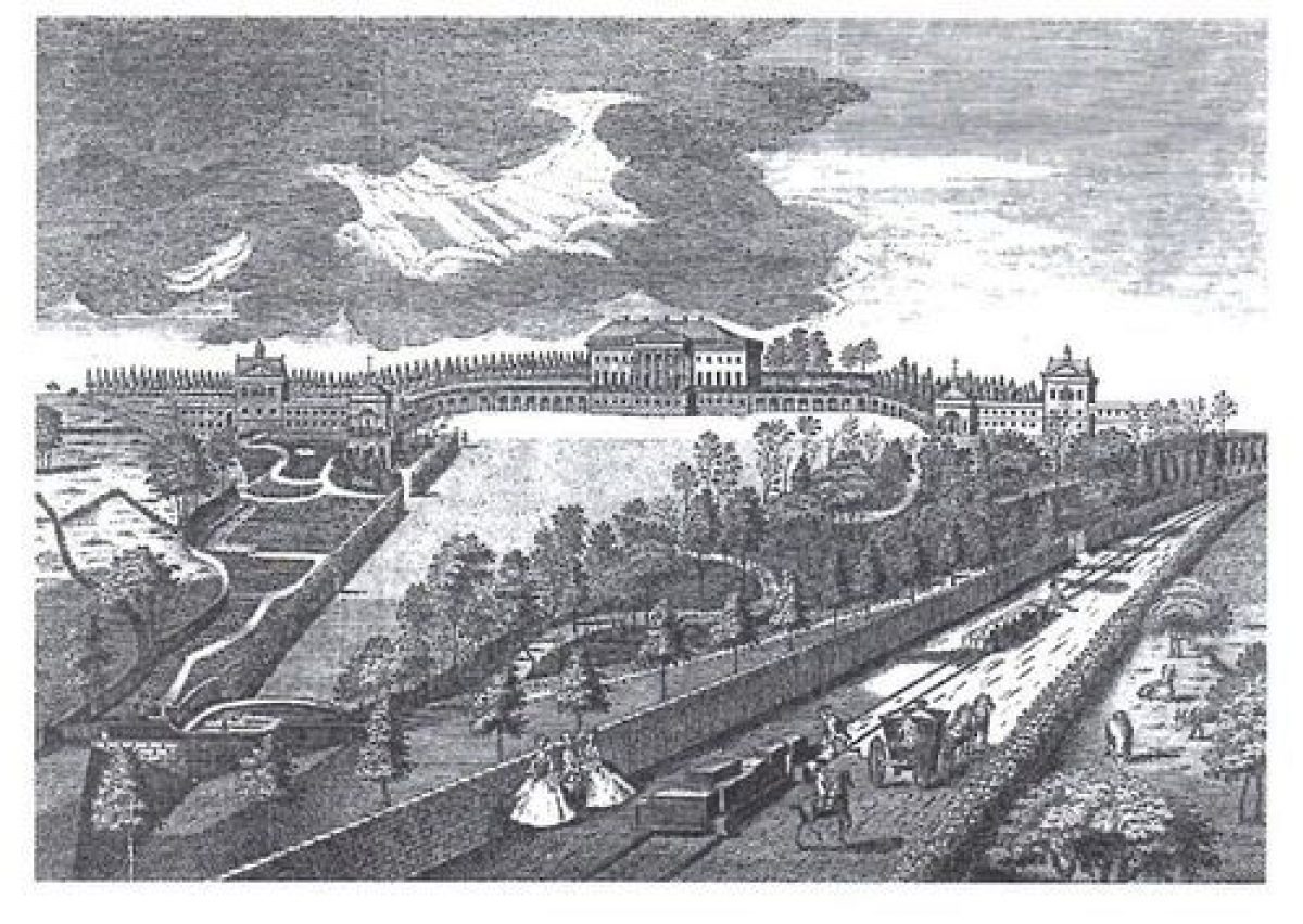
Between 1734 and c 1740, with advice from Alexander Pope (1688-1744) as well as Wood, Allen developed a formal landscape north of and below the house and a rococo wilderness to the north-west, with a triangular lawn north of the house descending to a formal pond and a boundary wall. The design featured a grotto, the serpentine river with a sham bridge and cascade, a statue of Moses, and the green 'cabinet' at the foot of the cascade with arti-natural winding paths around it. Wood's employment ended in 1748 before the house was complete, and Richard Jones, Allen's clerk of works at Prior Park, took over. In a second phase of works in the 1750s, the landscape was extended northwards and a Palladian bridge and a central cascade were introduced. Finally, a third phase can be identified after c 1760-4 when Allen employed Lancelot Brown (1716-83), who suggested removing the central cascade to make the whole of the combe a single sweep. Allen died in 1764 and his wife in 1766, after which the estate had a succession of owners, and over the next sixty-five years little was done to alter the designed landscape.
19th Century
In 1828 the estate was purchased by Bishop Baines, who founded a seminary in the house. Works were carried out to the house to designs by H E Goodridge in 1834. In 1836 there was a serious fire, and restoration costs crippled the seminary, which closed in 1856. After a period of neglect, it was bought by Bishop Clifford to found a Roman Catholic Grammar School. Works to the landscape were carried out in the 1880s. The school closed in 1904 and it was occupied by the army during the First World War and then by a series of tenants until, in 1921, the Christian Brothers took it over and founded a boys' boarding school in 1924. The school, Prior Park College, has continued to occupy the house, but in 1993 11.3ha of the park and pleasure grounds were acquired by the National Trust and have been the subject of a detailed restoration programme.
Additional Historical Information
The name ‘Prior Park' dates from 1100, when John de Villiula, first Bishop of Bath and Wells, made a park on the site. This ‘reminiscence of an ancient monastery' was sold to a Mr. Humphrey Colles, who later sold it to a Mr. Matthew Colhurst. When he died in 1560, his son Edmund took over and sold the Abbey House with the park ‘Prior Park'. The Prior Park portion was subsequently sold to Ralph Allen in 1742.
Ralph Allen was an extremely influential figure in Bath during the 18th century, and was several times Mayor of the City. He rose from humble origins in Cornwall, and made a fortune from his re-organisation of the postal service in the 1720s. He gained the attention of General Wade, and was promoted to Postmaster.
He went on to exploit the oolitic limestone quarries on Combe Down in the Bath area, and employed John Wood the Elder to design his country house at Prior Park. He deliberately set out to demonstrate the qualities of Bath stone in the design and construction of the house at Prior Park. The main building was completed by Richard Jones, Allen's Clerk of Works, after Wood's death in 1754.
Landscaping at Prior Park started in 1737, very much under the influence of Alexander Pope, who was then a good friend of Allen's. Pope was one of the key figures in the shift of ideas that took place in the early 18th century, and that affected garden design in a dramatic way. Pope believed in accepting as far as possible the natural character of the site, seeking not to change it, but to enhance it: ‘Nature's rules discovered, not devised'. Pope loaned his gardener, John Serle, to help at Prior Park, and he visited and corresponded regularly, keeping a keen eye on progress there.
During 1737, no less than 55,200 trees, mostly elm and Scots pine, were planted on the slopes of the valley and along the tops of the downs. This exaggerated the height of the downs. The floor of the valley was left bare, and water collected in a group of fishponds at the bottom.
Allen was obviously very much aware of the creations of other great landowners, and there are many similarities between individual features of the garden at Prior Park and other great contemporary gardens. Thus the Sham Bridge at Prior Park is reminiscent of Kent's cascade at Chiswick House, or Venus' Vale at Rousham. The arch over Pope's walk at Prior Park is similar to one at Mount Edgecombe in Cornwall, and the Palladian bridge was copied from that designed by Robert Morris at Wilton House.
An engraving of 1752 by Anthony Walker gives us a clear picture of Prior Park at that time. The western slope of the valley is clothed in ‘natural' woodland, with sinuous paths winding through. By way of contrast, the eastern slope is more formal, with paths and rivulets descending between beds of planting. There was a cascade leading to the serpentine lake in the grove.
The following description of the grounds comes from Defoe's tour of 1748:
‘The level ground near the house and buildings were used for chicken runs and guinea fowl. Greenhouses were also situated near the house. Below the house and gardens were laid out on two terraces and two slopes, but all these are adorned with vases, ornaments and other stonework; and the affluence of water is so great that it is received in three places; and after many agreeable little falls, at the head of one, there is a statue of Moses, down on his knees, in an attitude expressive of the emotion he must have shown after striking the rock and seeing the water gush out of it. The wandering walks were made with great labour; and although no broader than to allow two or three persons to walk abreast, yet in some places they appear with little cliffs on one side and small precipices on the other.'
This statue of Moses is no longer in evidence today. A statue commemorating General Wade has also disappeared.
Allen died in 1764, and the estate passed from his niece Gertrude to William Warburton, Bishop of Gloucester, who had been a frequent visitor. Gertrude died in 1796, and the estate passed to another niece, to her son, to a half-brother and then to a Mr. Brown. It was subsequently purchased by John Thomas, a Bristol Quaker.
In 1829, Prior Park was bought by Bishop Baines for £22,000. It was turned into a Roman Catholic theological college. He commissioned the architect H.E. Goodridge to add the immense Baroque flight of steps to the north front of the mansion in 1836, and the house was gutted by a serious fire in the same year. Baines died in 1843, and the college was closed in 1856.
The estate was re-purchased by Bishop Clifford for £23,000 in 1867.
- Associated People
- Features & Designations
Designations
Conservation Area
- Reference: Bath
The National Heritage List for England: Register of Parks and Gardens
- Reference: GD1041
- Grade: I
The National Heritage List for England: Listed Building
- Reference: Prior Park
- Grade: I
Features
- Palladian Bridge
- Description: The Palladian bridge was built in 1755 by Richard Jones. It is reminiscent of that at Wilton House. Apart from the plain plastered ceiling and the slated roof, the bridge is of Bath stone. The internal and external frieze is pulvinated, and the balusters are of a type which is not common in Bath. They have something of a Venetian character about them.
- Earliest Date:
- Latest Date:
- Mansion House (featured building)
- Description: Prior Park mansion was built by John Wood the Elder between 1735 and 1742 in the Palladian style. A Baroque staircase was added by H.E. Goodridge in 1836. It was described by Pevsner as 'the most ambitious and most complete recreation of Palladio's villas on English soil'.
- Earliest Date:
- Latest Date:
- Gate Lodge
- Description: This feature is the porter's Lodge North. Both Lodges were designed by John Wood in the Palladian style, virtually identical but much altered in detail. They date to the 1750s.
- Earliest Date:
- Latest Date:
- Gate Lodge
- Description: This feature is the porter's Lodge South. Both Lodges were designed by John Wood in the Palladian style, virtually identical but much altered in detail. They date to the 1750s.
- Earliest Date:
- Latest Date:
- Grotto
- Description: Pope's Grotto was built by Stephan Ginstan Tibb on the site of the grave of Allen's Great Dane. All that remains is a solitary arch, constructed of 'sponge' stone, which was probably obtained from Allen's quarries at Combe Down. A diary entry of T. Clark Jnr., Salop, in 1836 reads:'The roof and sides of this sweet retreat presented to the eye such a dazzling assemblage of shells, fossils, minerals, etc. as perfectly astonished us. The floor was almost as beautiful as the roof, being composed of a curious kind of stone perforated and inlaid with pine-cones, fragments of bone etc. arranged in tasteful forms, and the whole place exhibiting such a profusion of ornament and such a combination of taste and skill as I had never before witnessed.'
- Ornamental Bridge
- Description: This feature is the Sham Bridge. It terminates the view of the circular pool from the Serpentine walls. It was probably designed by Richard Jones in the 1750s. The feature consists of a low ashlar hemicycle wall with a central pedimental break with a low arch rising from the ground. There are vermiculated voussiors and vermiculation to the tympadun. There are smaller but similar terminal breaks without pediments. The feature is now much overgrown.
- Earliest Date:
- Latest Date:
- Walk
- Description: This feature is Pope's Walk. It was laid out ten years after Pope's death in 1754. It starts at the western gatepost at the Top Lodge and goes down to an old arch.
- Earliest Date:
- Latest Date:
- Garden House
- Description: This feature is The Priory. It is a small gothic house intended for the head gardener. It appears on the estate map of 1742. It was much extended and altered in the 19th century, possibly by Bishop Baines.
- Arch
- Description: This is the arch in the Priory grounds. It is in the Palladian style, sited to the south of the Priory. It was built in the 1750s.
- Earliest Date:
- Latest Date:
- Garden Building
- Description: This feature is the gymnasium. It is an Italianate structure, possibly to a design by H.E. Goodridge in the 1830s. It has been vandalised.
- Earliest Date:
- Latest Date:
- Gate
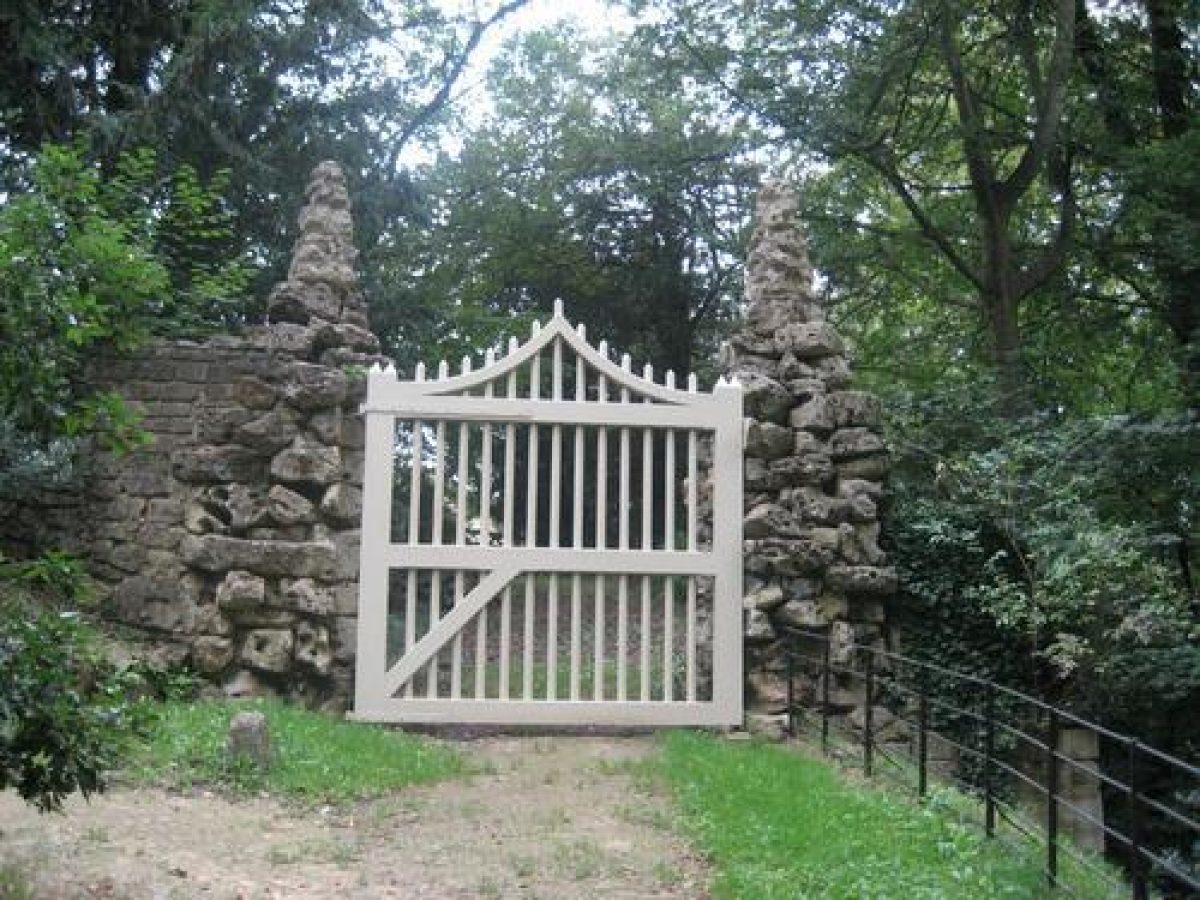
- Description: This feature is the middle gateway. It was built between 1740 and 1750. The gate piers are of random construction in vermiculated 'sponge' stone. The gate is wooden with a ramped upper rail. The feature was restored by Bishop Baines in the 1830s, but has fallen into disrepair. This is unfortunate, as it is an important surviving element of the 18th century garden.
- Earliest Date:
- Latest Date:
- Boundary Wall
- Description: To the south the site is bounded by a stone wall about 4.5 metres high.
- Folly
- Description: Sham Castle was built as an eyecatcher from Allen's town house in Bath.
- Earliest Date:
- Latest Date:
- Key Information
Type
Park
Purpose
Ornamental
Principal Building
Education
Survival
Extant
Hectares
22
Open to the public
Yes
- References
References
- {List of Buildings of Special Architectural or Historic Interest, City of Bath} List of Buildings of Special Architectural or Historic Interest, City of Bath
- Pevsner, N. {The Buildings of England: North Somerset and Bristol} (Harmondsworth: Penguin, 1958) pp 113-115 The Buildings of England: North Somerset and Bristol
- Haddon, John {Portrait of Bath} (London: Robert Hale, 1982) Portrait of Bath
- Foss, Vicki {Report on Prior Park} (1984) Report on Prior Park
- Walker, Anthony {View of Prior Park, the Seat of R. Allen} (1752) View of Prior Park, the Seat of R. Allen
- Defoe, Daniel {A tour through the whole island of Great Britain : Divided into circuits or journeys} (London: S. Birt, T. Osborne, 1748) A tour through the whole island of Great Britain : Divided into circuits or journeys
- Duke, Katy {The Garden Buildings of Prior Park} (1982) The Garden Buildings of Prior Park
- {English Heritage Register of Parks and Gardens of Special Historic Interest} (Swindon: English Heritage 2008) [on CD-ROM] Historic England Register of Parks and Gardens of Special Historic Interest
- Land Use Consultants {Prior Park, Bath: historic landscape survey} (1993) Prior Park, Bath: historic landscape survey
- Ferguson Mann {Prior Park Conservation and Development Plan} Prior Park Conservation and Development Plan
- Ward, Matthew {Prior Park Conservation Plan} (2002) Prior Park Conservation Plan
- Land Use Consultants {Prior Park Priory - Landscape Management Plan} (2006) Prior Park Priory - Landscape Management Plan
- Rutherford, Sarah {Prior Park Grotto: Conservation Statement} (2010) Prior Park Grotto: Conservation Statement
- Mowl, T., (1993) Palladian Bridges: Prior Park and the Whig connection
- Chapman, M., (1996) A guide to the Estates of Ralph Allen around Bath
- Bond, J., (1998) Somerset Parks and Gardens: a landscape history
- Country Life, 165 (22 March 1979), pp 873-6 Country Life, 165
- Clarke, G., (1987) Prior Park: a complete landscape
- Related Documents
-
CLS 1/344/1
Historic Landscape Survey - Digital copy
Land Use Consultants - 1993
-
CLS 1/484
Historic Landscape Survey - Hard copy
Land Use Consultants - 1993
-
CLS 1/344/1