Introduction
Osterley is an 18th-century landscape park laid out on the site of an earlier formal garden with substantial additional tree planting being undertaken in the 19th and 20th centuries. The site is dominated by three pieces of water: the Garden Lake (about 2 hectares), the Middle Lake (about 5.5 hectares), and the North Lake (about 3 hectares). The M4 motorway cuts across the northern part of the site.
Terrain
The site is largely level with a very slight slope from the north-east down to the south-west.
The following is from the Register of Parks and Gardens of Special Historic Interest. For the most up-to-date Register entry, please visit the The National Heritage List for England (NHLE):
Location, Area, Boundaries, Landform and Setting
Osterley Park is situated c 14.5km to the west of Hyde Park (qv), c 5km to the north of Hounslow, 4km to the west of Gunnersbury Park (qv), c 2.5km to the north of Syon Park (qv), and c 8km north-east of Heathrow Airport. Osterley Park is bounded to the east by Windmill Lane (B464). Jersey Road, including the gardens to the rear of houses on this road, forms the boundary to the south. Agricultural land and playing fields define the boundary to the west, and Tentlow Lane (A4127) the north-west boundary. The c 217ha site is largely level with a very slight slope from the north-east down to the south-west. It is dominated by three pieces of water: the Garden Lake (c 2ha), the Middle Lake (c 5.5ha), and the North Lake (c 3ha). The M4 motorway cuts across the northern part of the site.
Entrances and Approaches
Osterley Park is approached from Jersey Road to the south. The entrance, guarded by the late C19 lodge to the west, leads onto the tree-lined South Avenue. The drive passes after c 300m a mid C20 estate building to the east, then continues for a further c 300m to the visitors' car park (situated to the east of the drive), before swinging around to the south-west between Garden (southern) Lake and Middle Lake. It then follows the north bank of Garden Lake for c 100m before turning to the north-west, terminating after c 50m in the forecourt to the east of the mansion. The South Avenue was constructed in response to the arrival in 1883 of the railway at the Osterley Park and Spring Grove Station, c 1km to the south-west of the mansion. Additional pedestrian entrances are located in Osterley Lane which runs north-west from Wyke Green, in the south-east corner of the site.
The Wyke Green entrance is guarded by two early C18 lodges (listed grade II) designed by Robert Adam. Osterley Lane continues for c 650m before turning to the west, running parallel with the motorway for a further c 900m. Osterley Lane was the 'meandering route' to the mansion described by William Keane in his Beauties of Middlesex in 1850. The pedestrian entrance at the west end of Osterley Lane, guarded by two C18 lodges (listed grade II), Avenue Lodge to the east and Devon Lodge to the west, opened onto the final c 400m approach which runs south-east to the stables and mansion. This tree-lined drive was recorded on Rocque's map of 1746 and was one of the few landscape features which survived from the formal C17 gardens. The elms which lined the drive were felled in 1975 (victims of Dutch elm disease) and growth rings indicate that they were growing at the time Rocque undertook his survey. The elms had been replaced with lime and horse chestnuts by 1980. Some 300m to the east of Avenue Lodge is the C18 Jubilee Lodge (listed grade II) where a straight gravelled path, Jubilee Avenue, leads across the parkland, between a double avenue of largely young trees, to the stables. Most of the trees are replacements for those planted to mark Queen Victoria's Diamond Jubilee. This approach probably dates from the late C18 (Enclosure map, 1818).
Principal Building
Situated in the centre of the site, Osterley Park House (listed grade I) consists of red-brick wings of three storeys around a raised courtyard with a taller brick tower with stone quoins and ogee cap projecting at each outer corner. The courtyard is entered through a grand Ionic portico on the east side. The portico stands at the head of a flight of steps and provides an entrance to the state rooms on the first floor, this being on a level with the courtyard. On the west side of the house a curved double staircase leads down from a pedimented door in the first-floor gallery to the garden. The mansion overlooks the east lawn with views to the Middle Lake.
The earliest mansion was built for Sir Thomas Gresham c 1575 and was largely transformed into its present design by the architect Robert Adam in the 1760s-1770s for the then owner Sir Francis Child. Although the original ground plan of Gresham's mansion was largely preserved the fabric was extensively altered, Adam continuing his work for Robert Child after the death of Sir Francis in 1763.
To the north of the mansion is the red-brick stable block (listed grade I). Built around a three-sided courtyard, the two-storey building has attics and turrets in the two internal angles. The open side of the courtyard faces the mansion. Now (2000) used to house a restaurant, shop, and other visitor facilities, the stables have their origins in the C16 and, with the exception of the clock tower and clock added in 1714, are little altered from the time of Thomas Gresham.
Gardens and Pleasure Grounds
The c 8ha pleasure grounds lie to the south, west, and north of the mansion. Largely laid to lawn, the pleasure grounds are separated from the parkland to the west by iron fencing which follows part of the early C19 boundary line of the garden (Sale map, 1832). The grounds are screened from the neighbouring Osterley Park Farm to the north by a line of shrubs and trees. Some 90m to the south-east of the mansion is the late C18 Garden Lake which extends c 550m south-west from the bend in the South Avenue. At the north-east end of this piece of water, set on a small concrete island, is a cast-iron Chinese Temple which dates from 1987. The south bank is given over to shrubs and trees. The view of the Lake from the mansion is largely screened by the Cedar Grove. Originally planted by Robert Child's widow c 1785 to commemorate the birth of a grandchild, Sarah Sophia, most of the cedars existing today (2000) are thought to be later replacements (National Trust 1980). Some 200m to the south-west of the Grove is a tree-covered mound, which from at least 1832 (Plan made to accompany an offer of a lease) until c 1920 (OS) housed an icehouse.
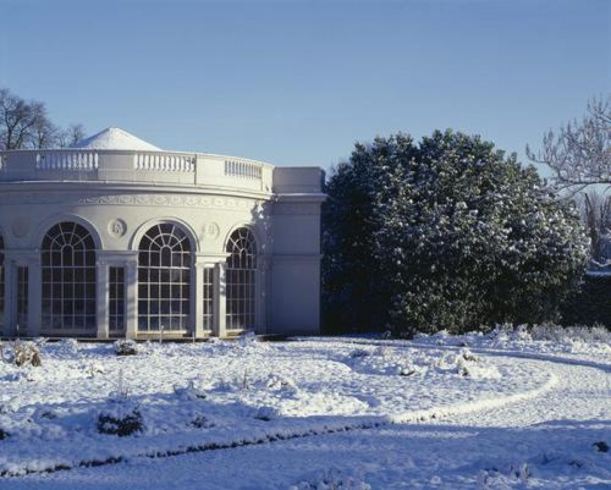
From the forecourt to the east of the mansion, a gravel path leads around the south-east side of the building, passing the Cedar Grove to the south, and continues across the south-west side of the mansion into the main area of the pleasure grounds. To the north-east is the walled kitchen garden, against the south-west wall of which is the Garden House (listed grade I). The stucco building, with conical slate roof, a semicircular front of five linked Venetian windows and Ionic pilasters, was designed by Robert Adam c 1780 for use as a plant house. The semicircular lawns to the west of the Garden House are divided with gravel paths and the cut beds in the segments are planted with seasonal flowers.
A c 150m wide lawn to the south-west separates the Garden House from the Temple of Pan. Standing c 220m to the north-west of the mansion, this small Doric temple (listed grade I) of Portland stone has a low Tuscan portico with eight columns, entablature, pediment, two double sash windows, and a glazed door. The temple is thought to have been designed by Sir William Chambers (Cherry and Pevsner 1991). The mid C18 interior plasterwork has rococo flourishes and medallions of Colen Campbell and Sir Issac Newton. The Orangery, designed by Robert Adam c 1780, formerly stood c 100m north-east of the Temple of Pan. Heated by flues and used, like the Garden House, as a plant house, the building was destroyed by fire during the Second World War.
Park
The c 209ha of level parkland around the mansion and the pleasure grounds is dominated by the three long narrow lakes. Garden Lake lies to the south, separated from Middle Lake by the main drive and a C20 shrubbery. The narrow southern end of Middle Lake runs north for c 300m before widening out as it nears Osterley Lane. This expanse of water is decorated with a small island. The third piece of water, North Lake, is largely situated to the north of the motorway which has divided the estate since 1974. On the north side of the east end of the Lake is the Aviary (listed grade II). Now a private residence, this C18 building, then known as the Menagerie, housed Mrs Robert Child's collection of exotic birds and was one of the great attractions of Osterley. Horace Walpole commented on 'a menagerie full of birds come from a thousand islands' (National Trust 1980). The Menagerie was surrounded by trees and walks forming a small park within the wider parkland. The meandering west end of North Lake extends for c 1km across agricultural land, formerly the C18 Menagerie Park, to the western boundary of the site. Part way along the western extension of North Lake is a stone bridge (listed grade II*). Designed by Robert Adam, the single-span stone bridge has central keystones decorated with carved heads. The bridge appears never to have been connected to any road but it may have been important as a footbridge connecting the two halves of Menagerie Park.
The parkland to the north of the motorway is now (2000) largely given over to agriculture while that to the east and south of the lakes is used for grazing.
Kitchen Garden
Two walled kitchen gardens exist at Osterley. The smaller (under 1ha) area is situated to the north-west of the stables. Thought to have been made in the C16, the area is shown as a walled enclosure on Rocque's map of 1746. The larger (c 2ha) walled area is situated to the south of Osterley Park Farm and is now (2000) in private ownership. Like the Farm, the walled garden is thought to date from the C18 (Cherry and Pevsner 1991). At the end of C19, some 20ha, including the large walled garden, were let to a Mr E Poole, the whole area at that time being planted with fruit trees (Gardeners' Chronicle 1885).
Maps
- J Rocque, Plan of the Cities of London and Westminster and Borough of Southwark, published 1746
- Heston Enclosure Award, Plan B, 1818 [reproduced in NT Garden Survey 1980]
- Greenwood, Map of Middlesex, 1818-1819
- Plan of Osterley made to accompany an offer of a lease, 1832 [reproduced in NT Garden Survey 1980]
- Estate map, 1875 [reproduced in NT Garden Survey 1980]
- OS 6" to 1 mile: 2nd edition published 1896
- 3rd edition published 1920
- OS 25" to 1 mile: 1st edition published 1865
- 2nd edition published 1894-1896
- 3rd edition published 1913
Description written: April 2000
Edited: July 2001, January 2023
- Visitor Access, Directions & Contacts
Telephone
0844 800 1895Website
http://www.nationaltrust.org.ukAccess contact details
The park is open daily, 8am to 6pm. For more detailed visitor information visit the National Trust website.
Directions
On A4 between Hammersmith and Hounslow.
Osterley tube station - Piccadilly line.
Owners
The National Trust
Heelis, Kemble Drive, Swindon, SN2 2NA
- History
The following is from the Register of Parks and Gardens of Special Historic Interest. For the most up-to-date Register entry, please visit The National Heritage List for England (NHLE):
16th Century
Reputed to be the site of a Norman fort or watch tower, the manor of Osterley passed through many hands until, in 1562, it came into the possession of Sir Thomas Gresham and the present structure of the park began to evolve. Gresham replaced the old farmhouse with a large manor house which is said to have stood in the middle of a pleasant park, well wooded and containing several fishponds and a heronry (National Trust 1980). Gresham died in 1579, two years after the completion of the house.
18th Century
Over the next 200 years Osterley again changed hands frequently and in 1711 the estate was sold to Sir Francis Child. When his grandson (also named Francis) inherited the property in 1752, he began to remodel the house, Sir Francis engaging Robert Adam (1728-1792) as architect in 1761 to redesign both the fabric and the interior of the house. Sir Francis died in 1763, but Robert Adam continued his work under the patronage of Sir Francis' brother, Robert Child. The park and gardens surrounding the house were extensively altered during the time of the rebuilding, the formal gardens (Rocque, 1746) being replaced by an informal park (Enclosure map, 1818). The design of the park has been attributed to Mrs Robert Child and her steward, Mr Bunce (National Trust 1980).
19th Century
In 1804 Robert Child's granddaughter, Lady Sarah Sophia Fane, who had inherited the estate, married the fifth Earl of Jersey and thus Osterley came into the possession of the Jersey family.
Extensive tree planting was undertaken throughout the 19th century, including fenced groups or islands of trees in the park and boundary plantings.
20th Century
The early part of the 20th century saw an increase in flower beds and shrubberies around the house along with further new trees in the park. During the Second World War a field to the east of the South Avenue was made into allotments and the park was given over to beef cattle and hay. The period between 1940 and 1980 saw the gradual disappearance of the park fences and the elm trees (some planted before 1740), victims of Dutch elm disease.
In 1949 the ninth Earl, Lord Jersey, gave the house and 57 hectares of the estate to the National Trust, and a further 77 hectares were acquired by the Trust in 1990.
21st Century
The National Trust retains ownership of these 134 hectares. The remainder of the park is in private ownership.
Period
- 18th Century (1701 to 1800)
- Late 18th Century (1767 to 1800)
- Associated People
- Features & Designations
Designations
The National Heritage List for England: Register of Parks and Gardens
- Reference: GD1215
- Grade: II*
Features
- House (featured building)
- Description: The manor house was built between 1562 and 1577. Sir Francis Child engaged Robert Adam as architect in 1761 to redesign both the fabric and the interior of the house.
- Earliest Date:
- Latest Date:
- Lake
- Description: There are three long lakes: garden lake, middle lake and north lake. They are arranged in a serpentine fashion.
- Specimen Tree
- Description: There is a cork oak, a Japanese Daimyo oak, Hungarian oaks and North American red oaks.
- Path
- Description: Nine Acre Path.
- Specimen Tree
- Description: There is a large Oriental plane tree.
- Earliest Date:
- Latest Date:
- Garden House
- Temple
- Description: Temple of Pan.
- Walk
- Description: The Outer Pleasure Ground Walk.
- Kitchen Garden
- Description: Two walled kitchen gardens exist at Osterley.
- Lodge
- Description: Two C18 lodges (listed grade II), Avenue Lodge to the east and Devon Lodge to the west.
- Stable Block
- Description: To the north of the mansion is the red-brick stable block (listed grade I).
- Aviary
- Description: Aviary (listed grade II), now a private residence, this C18 building, then known as the Menagerie, housed Mrs Robert Child's collection of exotic birds.
- Key Information
Type
Estate
Purpose
Ornamental
Principal Building
Domestic / Residential
Period
18th Century (1701 to 1800)
Survival
Extant
Hectares
217
Open to the public
Yes
- References
References
- {English Heritage Register of Parks and Gardens of Special Historic Interest} (Swindon: English Heritage 2008) [on CD-ROM] Historic England Register of Parks and Gardens of Special Historic Interest
- Cherry, B. and Pevsner, N. {The Buildings of England: London 3: North West} (London: Penguin, 1991) pp438-442 The Buildings of England: London 3: North West
- Sales, John {The National Trust Management Plan for Osterley Park} (1981) The National Trust Management Plan for Osterley Park
- Tait, AI and others {Gardens survey of Osterley Park, Middlesex} (2008) Gardens survey of Osterley Park, Middlesex
- Tait, Alex {National Trust Gardens Survey (Osterley Park)} (1980) National Trust Gardens Survey (Osterley Park)
- Colvin and Moggridge {Osterley Park: Historic Park Restoration Plan} (2005) Osterley Park: Historic Park Restoration Plan
- Brewer, Brayley and Nightingale., (1816) The Beauties of England and Wales
- Keane, W., (1850) Beauties of Middlesex
- (1885), pp 261-262, 267-268, 272 Gardeners' Chronicle II
- Vol 60, (20 November 1926), pp 782-791; (27 November 1926), pp 818-826; (4 December 1926), pp 858-867 Country Life
- Related Documents
-
CLS 1/439
Osterley Park Gardens Survey - Hard copy
NT Gardens Survey Team - 1980
-
CLS 1/439