Introduction
Milton Abbey is an 18th-century landscape park, which covered 300 hectares at its most extensive. The estate was divided in 1933, leaving a central area of landscape park around Milton Abbey of about 35 hectares.
The church is open daily. Milton Abbey School, which shares the site, is not open to the public.
Terrain
The terrain rises irregularly to the west and east of a valley sloping southwards. Heavily wooded slopes lie to the east.The following is from the Register of Parks and Gardens of Special Historic Interest. For the most up-to-date Register entry, please visit The National Heritage List for England (NHLE):
An extensive landscape park laid out in the second half of the C18 by Lancelot Brown.
Location, Area, Boundaries, Landform and Setting
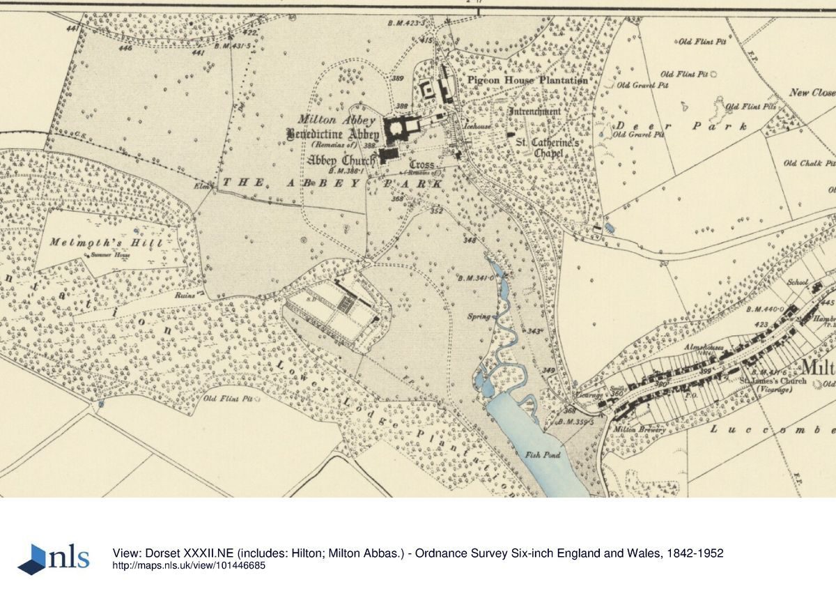
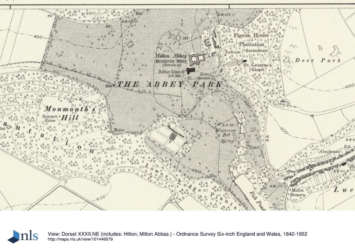
Milton Abbey is situated circa 4.5km north of Milborne St Andrew and the A354 road which leads north-east from Puddletown to Blandford Forum. The circa 535ha site comprises some 7ha of gardens and pleasure grounds, and circa 528ha of parkland, ornamental plantations and lakes. The site is bounded to the south and south-east by a minor road which runs east from Hilton to Milton Abbas, while to the north-east and north the boundary is formed by a minor road which leads north from Milton Abbas to Bulbarrow Hill, from which the site is separated by a stone park wall and by a park pale ditch. To the west, south-west and east the site adjoins agricultural land from which it is separated by a variety of hedges, banks and fences.
The site is undulating, comprising a dry downland valley extending north from the abbey to a high point adjacent to the northern boundary of the park, with a further valley extending westwards from the abbey towards the village of Hilton, the church tower of which serves as an eye-catcher in the landscape (outside the area here registered). A further valley drops away to the south of the abbey, where a stream is dammed to form an artificial lake. Southerly views through this valley are now (early C21) partly obscured by vegetation, while extensive views to the south and west survive from the higher ground north of the abbey.
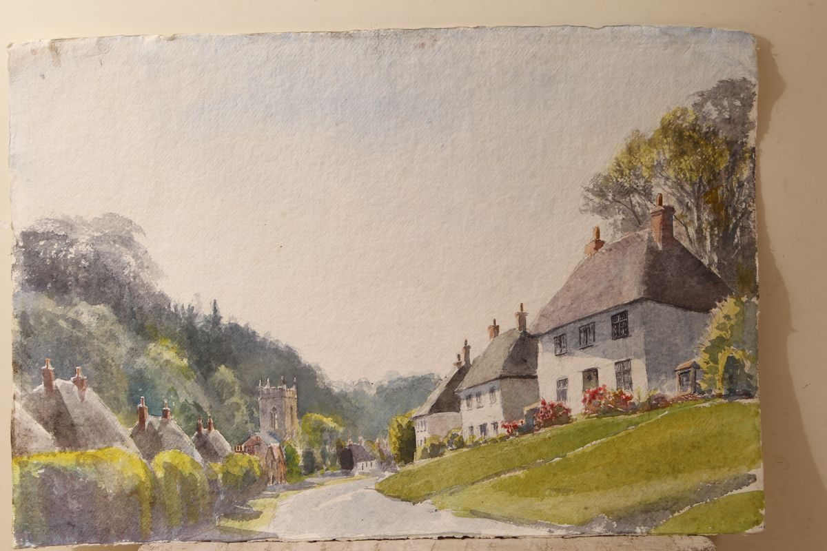
The late C18 village of Milton Abbas, laid out to a design of Lancelot Brown (1774) and with a church designed by James Wyatt (1786) as part of Lord Milton's extensive improvements is not included in the registered site, but forms part of its setting. Similarly, the minor road leading south from Lower Lodge to Milborne St Andrew, circa 1km of which is planted with an avenue, and which was laid out by Lord Milton in the late C18 as an approach to the abbey, forms part of the setting of the site.
Entrances and Approaches
The early C21 entrance to Milton Abbey is from the minor road which leads north and north-west from Milton Abbas to Hilton, at a point circa 200m north-east of the house. The entrance is marked by a pair of late C18 ashlar piers decorated with carved swags of flowers which support a pair of simple iron gates (all listed Grade II). Beyond the entrance, a tarmac drive leads south-west and south, adjoined to the west by lawns and C20 playing fields, and to the east by late-C20 school houses, to reach a carriage turn below the north façade of the abbey. From the carriage turn, a drive leads east to the stable court north-east of the house, the C18 and C19 buildings of which have been converted and extended in the C20 for school use.
Further drives lead north-east and south-east to join the minor road leading from Milton Abbas to Hilton. The present north drive replaces an earlier northern approach which followed a course circa 20m further west, joining the carriage turn on axis with the gatehouse leading to the central courtyard of the Abbey (OS, 1900). This earlier drive joined the minor road from Milton Abbas to Hilton at a point opposite a further drive, King Edward's Drive, which survives as a track (2004) leading circa 1km north-east through Combe Plantation top join the minor road forming the north-eastern boundary of the site. This drive passes the late C18 Stone Lodges (listed Grade II*), a pair of classical, two-storey stone lodges flanking square ashlar piers and wrought iron gates attributed to Sir William Chambers (listed building description) circa 800m north-east of the house, and emerges on to the minor road at High Lodge, a picturesque brick and flint Gothic cottage dating from 1909. King Edward's Drive is shown on Woodward's plan of Milton Abbey (1769), and probably formed part of Lancelot Brown's initial phase of improvements for Lord Milton.
The principal C18 approach to the Abbey was from the south. With the exception of the northern section adjacent to the Abbey, this drive survives as a track (2004) which enters the site at Lower Lodge, circa 320m south-west of Milton Abbas. Lower Lodge (listed Grade II) comprises a late-C18 single-storey stone cottage built in classical style, which adjoins a pair of wrought-iron gates supported by rusticated stone piers ornamented with carved swags. Beyond the entrance, the drive extends circa 400m north-west through the park, to the east of Lower Lodge Plantation and to the west of the lake. Sweeping north and north-west the drive passes to the northeast of the kitchen garden, and continues northwards through a pair of late-C18 stone piers to pass over a stream on a late C18 stone bridge circa 270m south-west of the Abbey. The bridge, probably designed by Chambers, has a parapet formed from pierced quatrefoil mouldings, matching late C18 ornamental details on the house and abbey church.
Beyond the bridge the drive now extends c 430m north to join the minor road leading to Hilton, but formerly swept north-east and south to join the north drive c 130m north of the Abbey. This arrangement, shown on the early C20 OS (1900), replaced an C18 drive shown on a late-C18 estate plan (DRO: Ph 67) which turned more sharply east to approach the carriage court north of the house from the north-west. The south drive is not shown on Woodward's estate plan (1769), at which time the village of Abbey Milton still occupied the ground to the south and below the Abbey church. The drive was formed as part of Brown's second phase of work for Lord Milton in the late C18, following the clearance of the village circa 1774, and was associated with the formation of the lake and southern park. The northern section of the C18 south drive was removed in the mid-C20 during the formation of playing fields north of the Abbey.
Principal Building
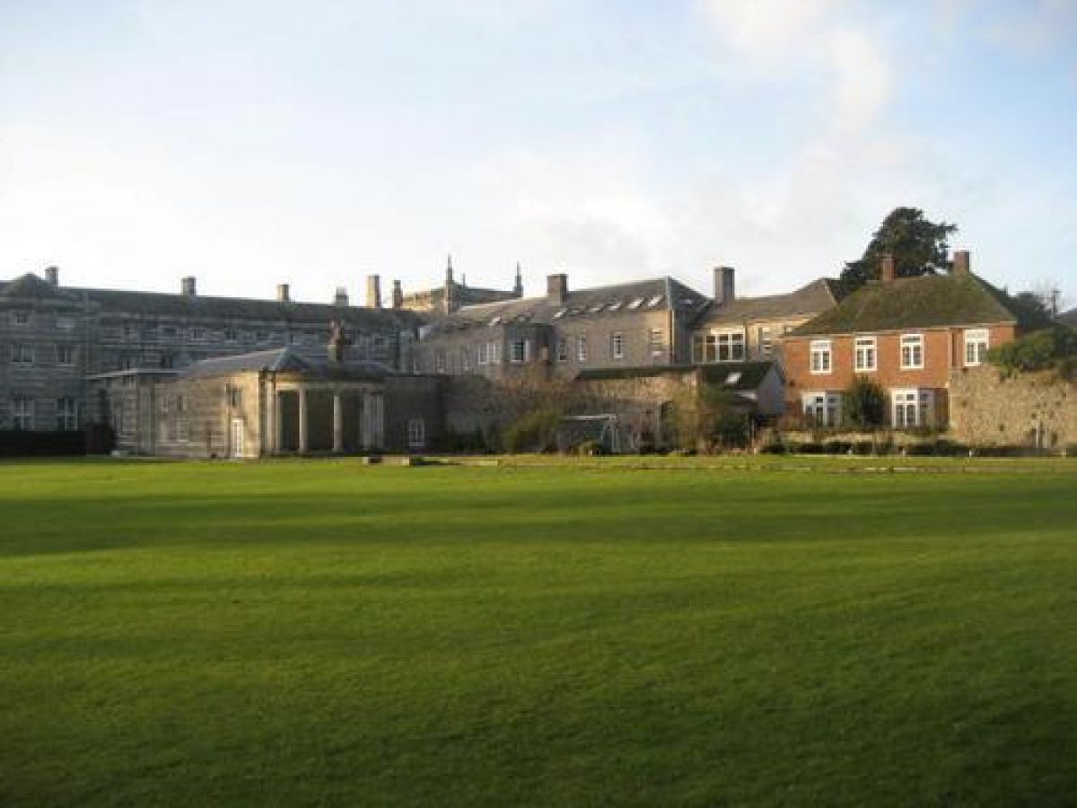
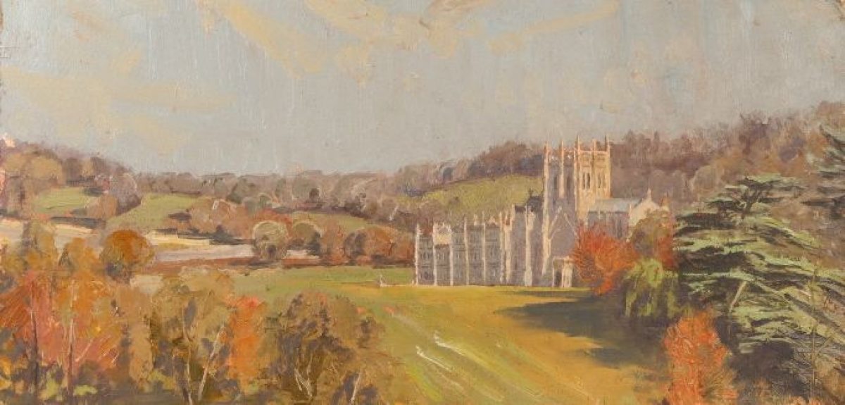
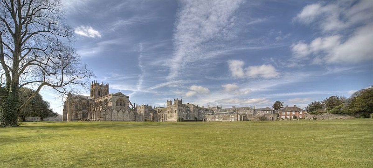
Milton Abbey (all listed Grade I; all Scheduled Ancient Monument) stands on an artificially-levelled terrace towards the centre of the site. The house is constructed around a central courtyard, with a further service court to the east. Constructed in ashlar under slate and lead roofs, the building comprises two and three storeys.
The entrance or north façade has a central porch tower, and is terminated to east and west by further projecting towers. The west façade, overlooking the park, has corner towers and a projecting central block comprising seven bays rising to three storeys. The north and west façades are ornamented with early Gothic revival details including ogee-headed and quatrefoil-shaped windows, pierced balustrades and pinnacles.
The south range of the house comprises the late-C15 abbot's hall and kitchen, and has a north façade, facing the courtyard, constructed in ashlar, and a southern façade, facing the pleasure grounds, of banded stone and flint. These mediaeval monastic structures were adapted for domestic use by John Tregonwell after he acquired the property in 1539, while the west range was partly rebuilt to the design of John Vardy for Jacob Bancks in the late 1730s. This work was continued by Lord Milton, who, according to Bishop Pococke, who visited in 1754, had the house cased 'all round in a beautiful modern manner' (Oswald, 1959). In 1770, Lord Milton commissioned Sir William Chambers to rebuild parts of the north, east and west ranges in a Gothic style harmonising with the mediaeval abbey church to the south. Chambers was replaced in 1775 by James Wyatt, who completed the rebuilding and decoration of the house (Oswald, 1959).
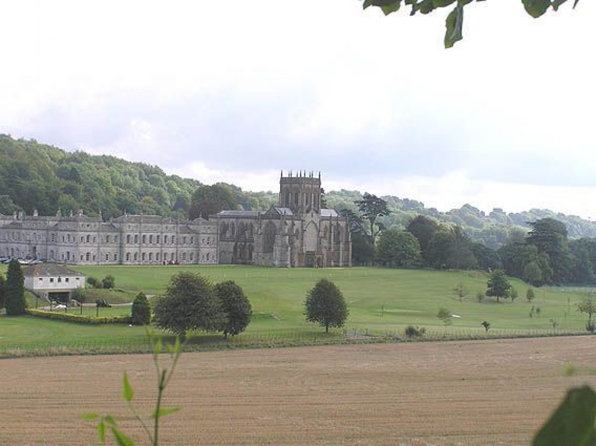
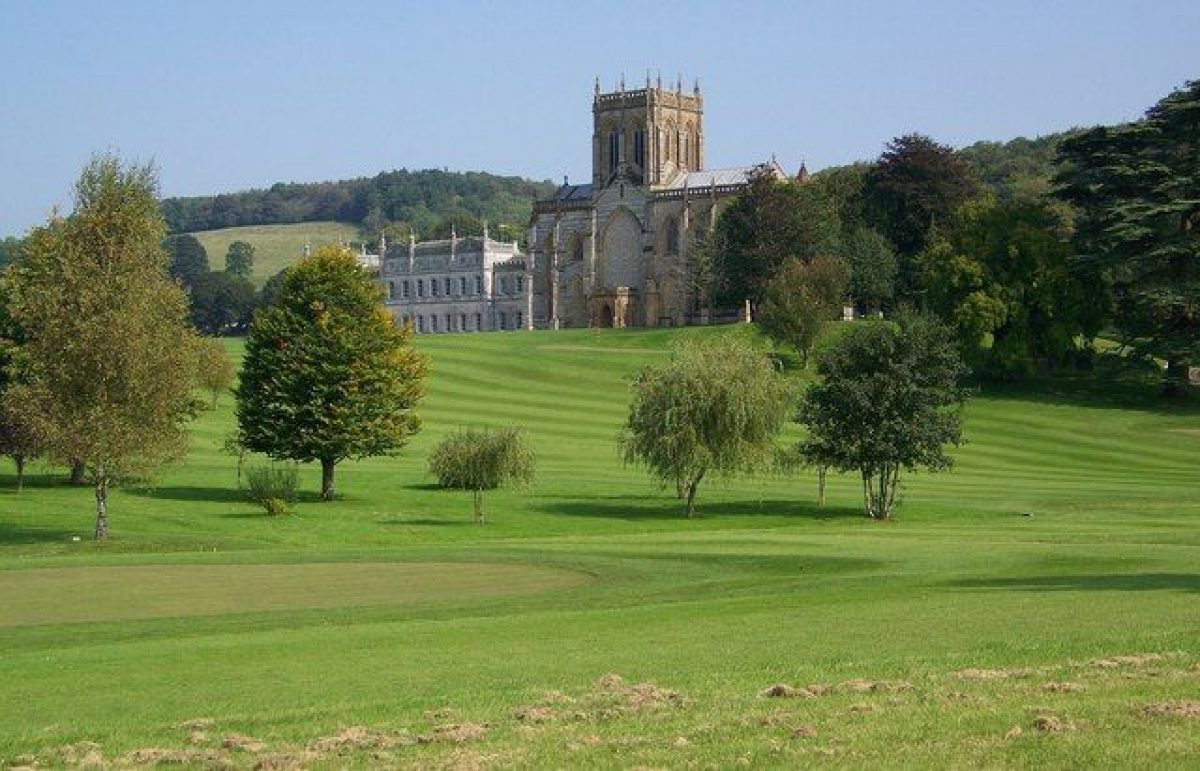
The abbey church of SS Mary, Sansom and Branwalader (listed Grade I; Scheduled Ancient Monument) stands circa 40m south of the house, and comprises the C14 choir, north and south choir aisles, transepts and central crossing tower of the mediaeval Benedictine abbey church. The present structure was begun in the early C14 to replace a Norman church which was destroyed by fire in 1309; it is possible that the nave was never rebuilt (Oswald, 1959). After the Reformation the church remained in parochial use, although in 1786 a new church was built in Milton Abbas. The abbey church was restored in 1789 by James Wyatt, who probably introduced the pierced quatrefoil balustrades to match those on the house. A further restoration was undertaken in 1865 by Sir Gilbert Scott.
Gardens and Pleasure Grounds
The informal pleasure grounds are situated principally to the north, south and west of the house. The carriage turn below the north façade of the house returns below the west façade, forming a gravelled terrace overlooking west-facing sloping lawns.
To the north, the terrace is terminated by a large, C18 stone urn (listed Grade II), ornamented with swags and putti. The lawns to the north and west of the house, which formed part of Brown's first phase of work at Milton from 1763, and which are shown on Woodward's estate plan (1769), have been partly re-graded and terraced to form school playing fields in the C20. A C19 ha-ha circa 150m west of the house separating the lawns from the park (OS, 1900), only survives to the south-west of the abbey church.
To the south of the church, the ground drops away towards the lake, views of which are now (2004) obscured by trees and scrub. Sloping lawns immediately south of the church are planted with a group of mature cedars, ilex oaks and evergreen shrubs, while a late-C20 all-weather games pitch has been constructed circa 150m south of the church. The sloping ground to the south of the church is shown on both Woodward's 1769 estate plan, and the undated late-C18 estate plan (DRO: Ph 67) as an enclosed burial ground, which was adjoined to the east by Market Street and domestic properties in the village of Abbey Milton. The burial ground was incorporated in to the pleasure grounds by Brown when the remnants of the village were cleared by Lord Milton circa 1774.
To the east of the abbey church a level lawn extends circa 100m to a late-C20 beech hedge and drive which leads south from the stable yard to Green Walk (listed Grade II; Scheduled Ancient Monument), an C18 thatched cottage which survives from the former village of Abbey Milton circa 130m south-east of the house, and the late-C20 Headmaster's House circa 160m south-south-east of the house. To the north, the lawn is enclosed by the service range, terminated to the east by an early-C20 semi-circular arbour supported by Ionic columns (roofless, 2004), to the east of which extends a slightly-raised, stone-edged grass terrace backed by stone walls screening the stable yard. The remains of the mediaeval market cross (listed Grade II; Scheduled Monument) comprising an octagonal stone base stand towards the south-east corner of the lawn circa 100m south-east of the house. Beyond the late-C20 beech hedge and drive to the east of the lawn, an area of level ground is laid out with a box-edged geometrical parterre planted with mature specimen Chusan palms.
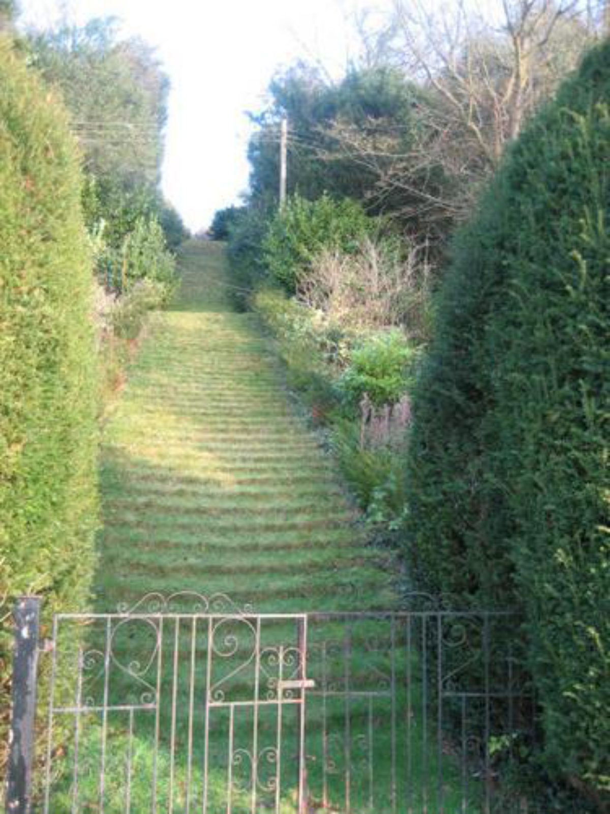
To the east of the parterre the steep, west-facing slope ascends to a terraced walk which extends circa 100m to reach a later-C18 brick bridge (listed Grade II) which crosses the minor road leading from Milton Abbas to Hilton. The terrace was planted in the early C20 as a rose walk with arches and swags (CL, 1915). The bridge is also approached from the level of the lawn by a monumental flight of grass steps, the foot of which is flanked by mature clipped yews, formerly cut in to topiary shapes (CL, 1915).
To the east of the bridge a further flight of grass steps ascends to St Catherine's Chapel (listed Grade I; Scheduled Ancient Monument) circa 240m east of the house, a late-C12 ecclesiastical structure originally associated with the mediaeval abbey. The east lawn occupies the site of a large walled garden and village premises which are shown on the late-C18 estate plan (DRO: Ph 67). This area was opened up and laid out as lawns by Brown in the late C18, while the formal gardens comprising the surviving parterre, rose terrace and grass steps, together with geometrical flower beds which do not survive (CL, 1915) were laid out in the mid- or late C19 (OS, 1887).
Park
The park extends to the north, west and south of the Abbey, and is today in mixed cultivation with arable land and school playing fields to the north and west, and pasture to the south. A dry valley, Delcombe Bottom, extends circa 3km north-northwest of the Abbey to high ground east of Bul Barrow. The valley sides are planted with mixed woodland which serves to frame extensive views from the Abbey. Some 1.4km north-north-west of the house, to the north of Horse Park Plantation, a structure now (2004) known as Keeper's Cottage (not inspected 2004), was formerly known as the Menagerie (OS, 1887), while circa 2km north of the house Delcombe Farm (now, 2004, known as Delcombe Manor, listed Grade II*) was rebuilt circa 1750 using mediaeval material from Milton Abbey to serve as an eye-catcher (Pevsner, 1972). Woodward's estate plan (1769) identifies the open floor of the valley as 'The Great Lawn', and also shows the enclosing wooded belts.
The creation of the park north of the Abbey formed part of Brown's first phase of activity at Milton from 1763, when a series of agricultural enclosures shown on Philip Byles' mid-C17 plan of Abbey Milton were removed. To the west of the house a further valley extends towards Hilton. The vista from the house and lawns is framed to north and south by the wooded slopes of Thomas's Hill Plantation and Monmouth's or Melmoth's Hill. This arrangement reflects that shown on Woodward's estate plan (1769) and form part of Brown's first phase of improvements for Lord Milton. To the south of Melmoth's Hill, a contiguous belt of mixed woodland, Lower Lodge Plantation and Ruins Plantation, extends from southeast, adjacent to Lower Lodge, to north-west enclosing the south and south-western sides of the park.
A narrow valley, St Thomas' Vale (Woodward, 1769), extends westwards into Ruins Plantation circa 480m south-west of the house. At the eastern end of this valley, a folly (listed Grade II; Scheduled Monument) representing the ruins of a chancel and transept of a gothic church, serves as an eye-catcher. The folly appears to incorporate fragments of mediaeval stonework, presumably removed from the abbey church, perhaps during its restoration by James Wyatt in 1789. The structure is not shown on Woodward's estate plan of 1769, but was present by the late C19 (OS, 1887), when a summerhouse also stood on Melmoth's Hill (unlocated, 2004).
The park to the south of the Abbey comprises a valley enclosed by Lower Lodge Plantation to the south-west, and by the wooded slopes of St Catherine's Hill to the north. A stream flows from north to south through the valley, and is dammed on the southern boundary of the park to form an informal lake. A marshy area to the north of the lake indicates the extent of the ornamental water created by Brown for Lord Milton circa 1774 on the site of the former village; it appears that the lake never achieved its intended extent (Stroud, 1975).
A footpath leading south from the boundary of the pleasure grounds through the park and along the eastern side of the lake leads to the late-C18 model village of Milton Abbas, emerging adjacent to Lake Lodge (listed Grade II), an early- or mid-C19 picturesque thatched cottage ornée. The village (outside the area here registered) occupies a valley which ascends eastwards from the lake. The wooded slopes above the thatched cottages form part of the setting of the park.
The C18 park created by Brown and Lord Milton took in former agricultural land, together with the site of the mediaeval village south of the abbey. Taylor's Map of Dorset (1769) shows an avenue extending north of the house through the lower end of Brown's Great Lawn, and a geometrical arrangement of trees recorded by Woodward on his estate survey (1769) may reflect this feature. John Speed does not indicate a park at Milton on his county map (1610), but Philip Byles' plan (1652-8) notes Milton Park, an area of woodland circa 0.5km east of the late-C18 village. This woodland (outside the area here registered) survives in the early C21, and conforms to the mediaeval abbots' hunting park (Oswald, 1959). The wood is delineated on Woodward's plan (1769), where it is shown, as today, as a detached area without any obviously ornamental treatment.
In the late C18 or early C19 an approximately triangular area to the south-east of King Edward's Drive and immediately south of Stone Lodges was adapted as a park for a herd of 300 fallow deer. It was disparked circa 1860 (Shirley, 1867).
Kitchen Garden
The kitchen garden is situated circa 0.5km south-south-west of the Abbey, on level ground to the north of Lower Lodge Plantation. Approximately rectangular-shaped on plan, the garden is enclosed by brick and stone walls circa 3m high, and is screened from the house and pleasure grounds by a belt of trees and evergreen shrubbery. The bothies to the north-east of the garden have been converted and extended in the mid-C20 to form a dwelling; the interior of the garden was not inspected (2004).
The kitchen garden appears to correspond to the enclosure marked as 'Lord Milton's Kitchen Garden' on the undated late-C18 estate survey (DRO: Ph 67), while the open ground to the south-west of the garden corresponds to 'Lord Milton's Orchard and Flower Garden' (DRO: Ph 67). These features are not shown on Woodward's 1769 estate survey, and it is likely that the kitchen garden was formed by Brown as part of his second phase of work for Lord Milton after 1773. The early-C20 OS (OS, 1900) shows a cruciform arrangement of walks within the garden, with an extensive group of glasshouses to the north-east and a sundial to the north-west. It is not known to what extent these features survive today (2004).Reasons for Designation
The extensive C18 landscape at Milton Abbey, designed by Lancelot Brown, is included on the Register of Parks and Gardens at Grade II*, for the following principal reasons:
* Relative date: the landscape was laid out in circa 1763-82, during the great phase of English landscape design, and has been little altered since;
* Historic association: it was designed by Lancelot 'Capability' Brown, the leading exponent of the more informal, naturalistic style of garden design which became hugely popular and highly influential in the second half of the C18;
* Historic interest: the park was laid out for Lord Milton to surround Milton Abbey, the late-C15, C16 and C18 house at the heart of the landscape, with which it is still associated;
* Group value: with Milton Abbey (listed Grade I and a scheduled monument), the numerous listed buildings within the registered area associated with the estate, and with the listed buildings within the model village of Milton Abbas, which was designed by Brown for Lord Milton to replace the village of Abbey Milton, demolished to make way for the parkland.
Selected Sources
Book Reference - Author: Stroud, D - Title: Capability Brown - Date: 1975 - Page References: 118-20
Book Reference - Author: Shirley, E P - Title: Some Accounts of English Deer Parks - Date: 1867 - Page References: 94
Book Reference - Author: Pevsner, N and Newman, J - Title: The Buildings of England: Dorset - Date: 1972 - Page References: 286-94
Book Reference - Author: Oswald, A - Title: Country Houses of Dorset - Date: 1959 - Page References: 108-13
Article Reference - Title: Country Life, 11 - Date: 15 February 1902 - Journal Title: Country Life - Volume: 11 - Page References: 208-13
Article Reference - Title: Country Life - Date: 29 May 1915 - Journal Title: Country Life - Volume: 37 - Page References: 734-41
Article Reference - Title: Country Life - Date: 5 June 1915 - Journal Title: Country Life - Volume: 38 - Page References: 770-6
Article Reference - Title: Country Life - Date: 30 June 1966 - Journal Title: Country Life - Volume: 139 - Page References: 1718-21
Article Reference - Title: Country Life - Date: 21 July 1966 - Journal Title: Country Life - Volume: 139 - Page References: 152-6
Article Reference - Title: Country Life - Date: 28 July 1966 - Journal Title: Country Life - Volume: 139 - Page References: 208-12
Map Reference - Title: Map of Dorsetshyre - Date: 1610
Other Reference - Description: Dorset Record Office (uncatalogued) : Philip Byles - A Brief Survey of the Manor of Milton Abbey (1652-58)
Other Reference - Description: Dorset Record Office: D919/5 - N Woodward: Survey of Milton Abbey, 1769
Map Reference - Title: Map of Dorset - Date: 1769
Other Reference - Description: Dorset Record Office: Ph 67 - Plan of Milton Abbey, the site of the mediaeval village and intended site of the lake, circa 1780
Other Reference - Description: Dorset Record Office: D/ALM:26 - Early C19 engraved views of Milton Abbey
- Visitor Access, Directions & Contacts
Access contact details
The church is open daily from 10am to 5pm and there are a number of public footpaths from which the landscape can be viewed.
Milton Abbey School, however, which shares the site, is not open to the public.
Owners
Milton Abbey School
Blandford Forum, DT11 OBZ
- History
The following is from the Register of Parks and Gardens of Special Historic Interest. For the most up-to-date Register entry, please visit The National Heritage List for England (NHLE):
History
An abbey was founded here by King Athelstan after the Battle of Brunenburgh, in which the king secured a victory over the Danes, circa 940. The abbot was granted rights to hold a market, and a community, originally known as Middleton, grew up adjacent to the monastery. By the time of the Dissolution, the abbot enjoyed not only market rights, but also licence to hold a fair, and free warren within the manor of Milton (CL, 1902). When the monastic house was dissolved in 1539, the manor was granted to John Tregonwell, one of the Commissioners for the surrender of the monasteries, in return for a payment of £1,000 (Oswald, 1959). Tregonwell, who was subsequently knighted, made over the abbey church to the parishioners of Milton and converted the monastic buildings into a house, in which he and his descendants lived for circa 150 years. In the early C17, John Tregonwell III purchased Anderson Manor, Dorset (qv), to which he retired in 1624, leaving Milton to his elder son. His grandson, John Tregonwell V died without a male heir, and in 1696 his daughter married Sir Jacob Bancks, nephew of the Swedish ambassador. On Bancks' death in 1724, Milton was inherited by his second son, also Jacob, who died intestate in 1737, shortly after beginning to rebuild the western range of the C16 mansion (Oswald, 1959). After some fifteen years of litigation between rival Bancks and Tregonwell claimants, the estate was sold in 1752 to Joseph Damer of Winterborne Came, Dorset, who was married to the daughter of the first Duke of Dorset. Damer, who was created Lord Milton in 1753 and Earl of Dorchester in 1792, commissioned John Vardy to complete the work begun by Jacob Bancks. In 1763, Lord Milton called in Lancelot Brown (1716-1783) to form a landscape park around the mansion, the medieval abbots' park having been situated circa 1km east of the abbey. Work continued until October 1770, by which time Brown had received £2,052 8s 0d from Lord Milton (Stroud, 1975). Between 1770 and circa 1774, Milton concentrated on rebuilding the remainder of the C16 house, employing as his architect first Sir William Chambers (1726-96), and subsequently, after disagreements, James Wyatt (1746-1813). In 1774, Brown was again consulted, preparing plans for the construction of a new model village, Milton Abbas, to replace the remnants of the mediaeval village adjacent to the mansion which stood in the way of the construction of a proposed lake (Stroud, 1975). Brown's work for Lord Milton continued until 1782, by which time the lawns and plantations north and west of the house had been formed, as well as the new village, lake and further plantations in the valley to the south.
The first Earl of Dorchester died in 1798, and was succeeded by his second son, who in turn died unmarried in 1808, at which point the Earldom became extinct. The Damers' estates at Milton and Came then passed to the second Earl's sister, Lady Caroline Damer, who died in 1829 and was succeeded by her cousin, Capt Henry Dawson RN, younger son of the second Earl of Portarlington. In 1852 the fourth Earl of Portarlington sold the Milton estate to Charles Joachim, Baron Hambro of the Kingdom of Denmark. Baron Hambro made few changes to the house, but spent considerable sums restoring the abbey church, employing Sir Gilbert Scott as his architect. Baron Hambro was succeeded by his third son, Sir Everard Hambro, who in 1932 was forced by economic circumstances to sell the estate, which was then broken up. The house and part of the grounds were subsequently acquired by the Ecclesiastical Commissioners, and the house was used as a centre for faith healing until circa 1950. By 1953, when the house was threatened with demolition, a trust was formed to open a boys' public school at Milton. In the early C21 the site is in divided ownership, with the mansion, abbey church and the immediate grounds remaining in institutional use.
Period
18th Century (1701 to 1800)
- Associated People
- Features & Designations
Designations
The National Heritage List for England: Register of Parks and Gardens
- Reference: GD1712
- Grade: II*
Features
- Abbey (featured building)
- Description: Milton Abbey is mainly 14th century, and was restored in about 1790 by James Wyatt, with later work in 1865 by Sir Gilbert Scott.
- Earliest Date:
- Latest Date:
- Ornamental Bridge
- Description: Footbridge.
- Earliest Date:
- Latest Date:
- Steps
- Description: A grass stair, possibly of Brown's period.
- Folly
- Description: A Gothic folly, of late-18th century date, situated about 600 metres south-west of Milton Abbey.
- Earliest Date:
- Latest Date:
- Key Information
Type
Park
Purpose
Ornamental
Principal Building
Education
Period
18th Century (1701 to 1800)
Survival
Extant
Hectares
35
Open to the public
Yes
Civil Parish
Milton Abbas
- References
References
- Stroud, D {Capability Brown} (1975) 118-120 Capability Brown (Country Life article)
- Newman, J and Pevsner, N {The Buildings of England: Dorset} (Harmondsworth: Penguin, 1972) pp 285-294 The Buildings of England: Dorset
- {English Heritage Register of Parks and Gardens of Special Historic Interest} (Swindon: English Heritage 2008) [on CD-ROM] Historic England Register of Parks and Gardens of Special Historic Interest