Introduction
Lower Gatton Park is a park and pleasure grounds forming the setting for a country house.
Terrain
On the lower slopes of the North Downs.www.historicengland.org.uk/listing/the-list
Park and pleasure grounds forming the setting for a country house, with improvements to the existing park in the 1760s and 70s by Lancelot Brown; mid C19 remodelling around the house. Gardens remodelled in the late C19 by H E Milner, and further elaborated during early C20.
DESCRIPTION
LOCATION, AREA, BOUNDARIES, LANDFORM, SETTING
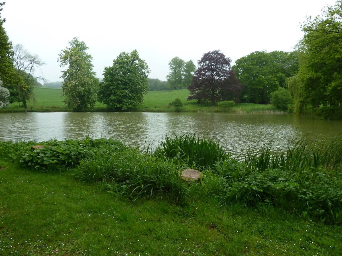
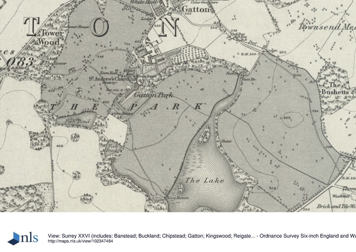
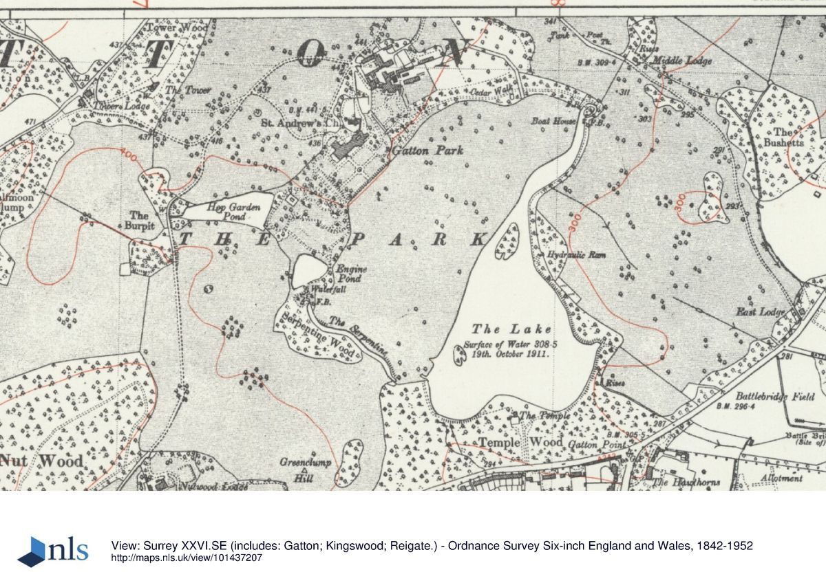
Lower Gatton Park lies 3km to the north of Reigate, on the lower slopes of the North Downs. The 234ha site is bordered by Gatton Bottom road to the north-west and Wray Lane to the west. Gatton Park Road (A23) forms the boundary to the south, the earlier southern edge of the park having been straightened with the building of the public road in the mid C18. Rocky Lane, a former drive, provides the boundary to the north-east. The c 11ha lake lies towards the east corner of the site with rising land to the north and west.
ENTRANCES AND APPROACHES
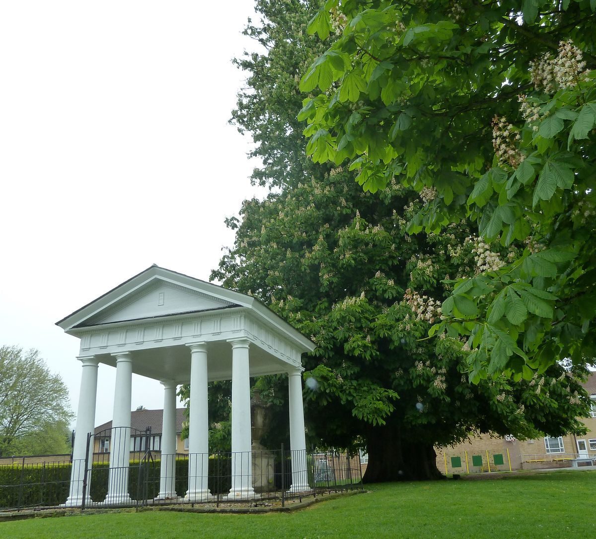
The main gate into the park is at North Lodge (listed grade II). The Lodge, a thatched cottage orne, stands c 400m to the north of the house by the hamlet of Gatton and probably dates from the ownership of Sir Mark Wood. From the main gate a drive leads south-west and after c 300m passes, to the north-west, the late C18 Gatton Town Hall (listed grade II), a small, square, open-sided building in Neoclassical style with eight Doric columns, triglyph frieze and pediment. This was where, until the parliamentary reforms of 1832, two candidates were returned to parliament. To the south-east of the track, c 50m north of the mansion, is St Andrew's church (listed grade B). The C13 church was restored and gothicised by the fifth Baron Monson in 1834.
The North Lodge is approached from Rocky Lane to the south-east. Rocky Lane originated as an entrance drive in the mid C19 and leads north-west from East Lodge on London Road via, after 700m, Middle Lodge, where the ground rises and continues another 600m to the main gate at North Lodge.
In the past access was gained by a number of additional approaches. An early C19 drive (now, 1998, a public bridleway) from West Lodge (listed grade II) at the south-west end of Gatton Park Road, ran north across the west side of the park to the mansion. The northern end of this drive was altered at the beginning of C20 to cross over an arch at the west end of Hop Garden Pond. From the north-west side of the site the Upper Drive (now, 1998, part of the North Downs Way) entered at a point formerly marked by a pair of lodges, and snaked across the north side of the park. The Upper Drive linked with the drive from West Lodge before branching (at the site of the former stables) to provide an approach to the north front of the house. In the late C18, the Upper Drive branched to the west of the mansion, crossing the park to continue south of The Lake to make a circuit.
PRINCIPAL BUILDING
The mansion house at Gatton Park (listed grade II) stands on the crest of the hill, north-east of centre of the park. The main front enjoys panoramic views out over parkland which falls from the south garden terrace to the shore of The Lake. The mansion has been rebuilt many times during the history of the site. The house was substantially reconstructed if not quite rebuilt on a grander scale by the sixth Lord Monson making it 'a very fine example of the Italian style of house' (VCH 1911). The house was rebuilt by Sir Jeremiah Colman in neo-Georgian style after a fire in 1934, the prostyle hexastyle Corinthian portico (the reason for the building being listed), which Jeremiah Colman had added to the north side in 1891, being retained in the new design.
GARDENS AND PLEASURE GROUNDS
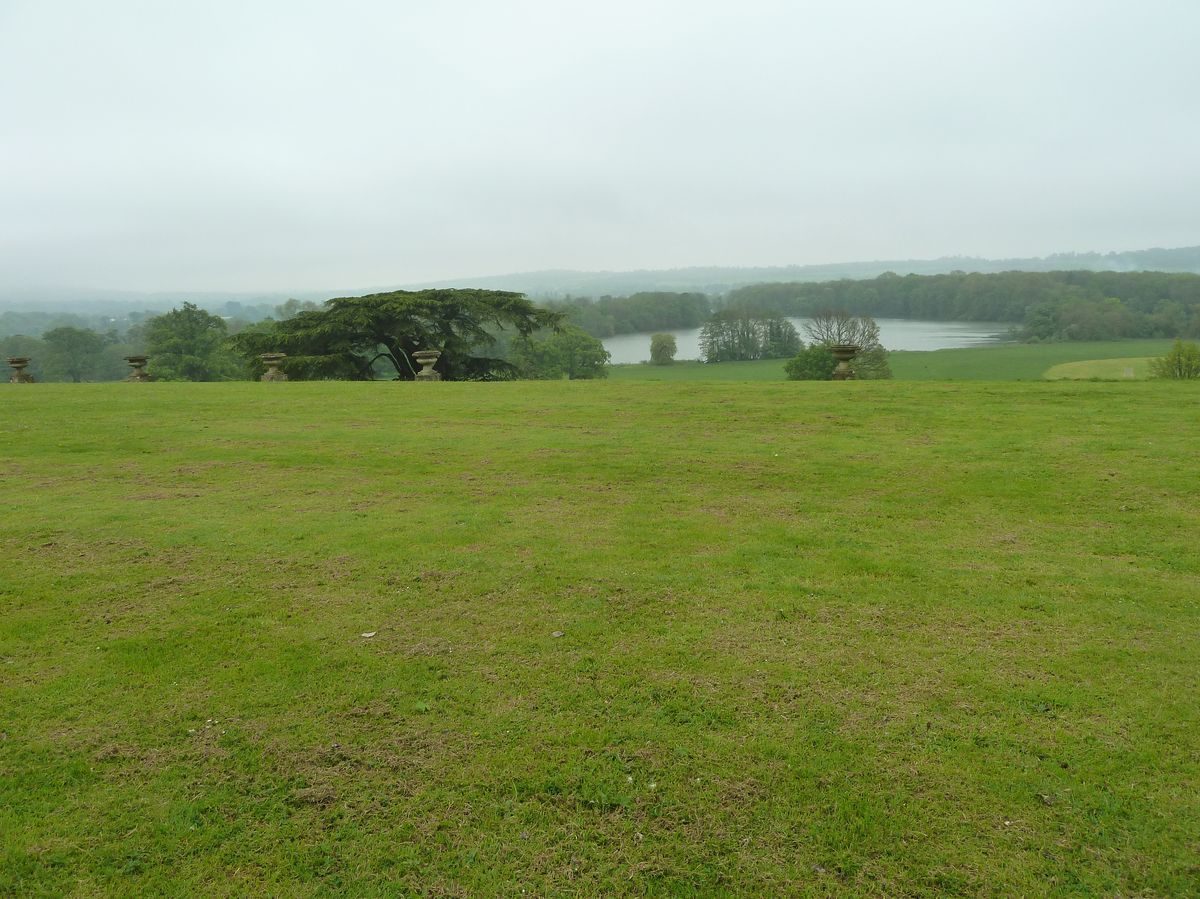
Below the main, south front of the mansion lies a broad, gently sloping grass terrace. As laid out and described by Keane (1849), the terrace was divided into four quarters by broad gravel walks which radiated out from a fountain vase in the centre. The southern edge of the terrace was marked by a line of urns. Much of the terrace was levelled in the mid C20 and is taken up by asphalt tennis courts, which impinge on the view across The Lake although a number of the urns survive.
From the north-east end of the terrace, a path leads east over a 'dry arch' (listed grade II and existing by 1838). The arch, built mainly of Gatton stone, passes over a service drive which leads to the kitchen garden. From the top of the arch the path leads to the Edwardian rockery (listed grade II). The steeply falling ground to the east of the house, beyond the terrace, was excavated by Colman in 1912 using unemployed labour. J Pulham and Son constructed the rockery, pools, and cascades using Kentish Ragstone and their own artificial Pulhamite stone and as a result of this project, there was 'a complete transformation of a shrubbery to a rockery and cascade adapted for heaths, alpines, and bog plants and aquatics' (J Horticulture and Home Farmer 1913). In 1998 the area was undergoing repair and restoration.
Beyond the rockery, to the east, is the late C18 Cedar Walk, a strip of wooded ground running down for c 400m between parkland to the northern end of The Lake. The Walk was first recorded on a survey of 1790 when it was probably planted with mixed evergreen and broadleaved trees with the area behind the path thickened with a shrubbery. Some of the present (1998) trees are thought to date from the original planting (Couch 1998). This path was also known c 1832 as Lady Cowper's Walk and at that time continued south-east to link up, via a bridge or ford over the north end of The Lake, with London Road. The small overgrown pond half way down the Walk on the west side was first recorded in 1869 (OS).
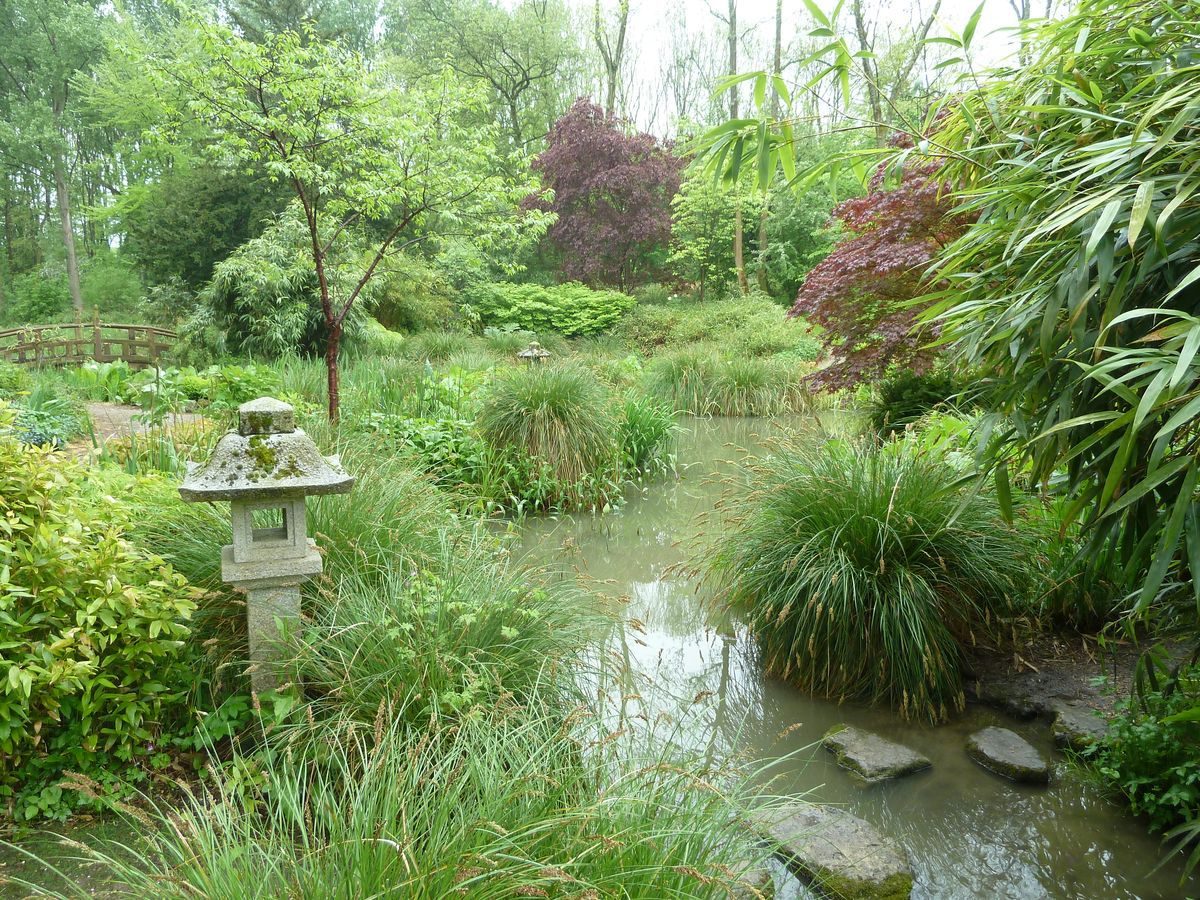
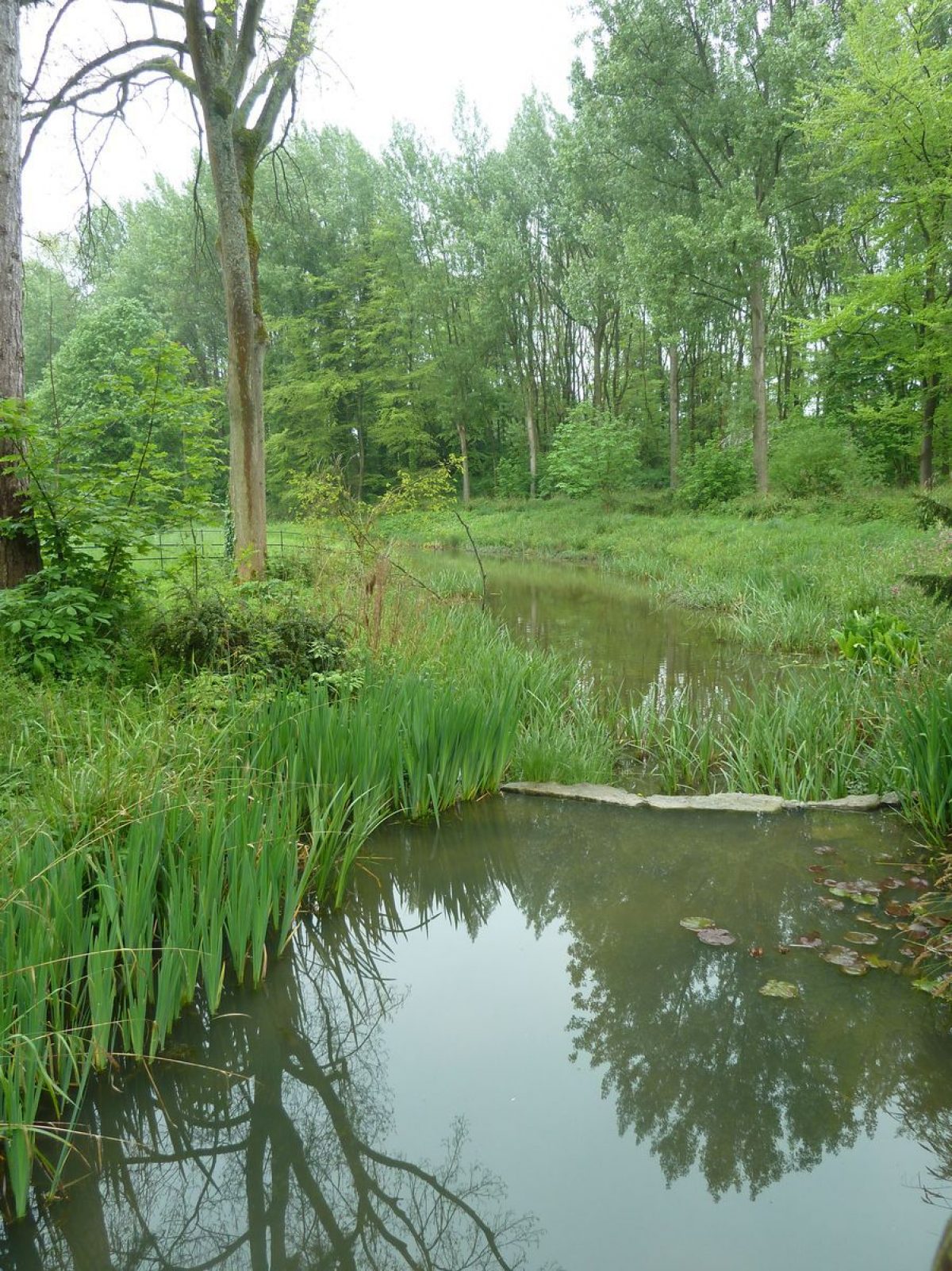
The area to the west of the grassed terrace was substantially developed by Colman and E H Milner and features, now gone, included a classical Rose Temple, flower beds, urns, and a sundial. Paths descend to the west past the C20 building which houses the swimming pool to what was described in the sale catalogue of 1888 as a 'lovely Dell'. This is now (1998) neglected and overgrown but the winding pebble paths survive in places and plans are in hand to reinstate them. The area has been variously recorded as the Hop Garden (C18) and a formal garden (Rocque, 1768). The formal garden was removed as part of Sir George Colebrooke's landscape improvements and was redesigned in the late C19 by Colman and Milner with serpentine paths through undulating lawns, and island beds with shrubs and evergreens. The area also contained an Old World Garden, first mentioned in 1896 (Gardeners' Chronicle) as a rose garden planted within neatly clipped yew hedges (now out grown). A rectangular stone-edged pool which formed part of the design still (1998) holds water. By 1913 the roses were being replaced by herbs. To the south-west of the Old World Garden is the Hop Garden Pond (c 1ha), altered to its present wedge shape around the time of Brown's involvement at Gatton. Some 150m to the south-east of the Hop Garden Pond is Engine Pond (c 0.4ha), also altered in the 1760s. The water from the Engine Pond, which eventually leads into The Serpentine, a narrow piece of water which winds for c 300m south-east towards The Lake, first passes through the Japanese Garden. Made 1911?12, the Japanese Garden (now, 1998, overgrown) was described in 1913 as having among other attractions a rustic bridge, wooden Japanese lanterns, bog plants and bamboo, and a summerhouse.
PARK
The path from Cedar Walk to the east of the site continues south following the route of the C18 perimeter path around The Lake. The c 11ha lake with two islands was developed from an existing crescent of water (Rocque, 1768) by Lancelot Brown as part of the improvements to Lower Gatton Park for Sir George Colebrooke in the 1760s. After c 250m the lakeside path passes to the north-west the site of a bridge or ford which led north to Lady Cowper's Walk. To the south-east of the path is a belt of trees bounded by a curved avenue of horse chestnuts (planted late C19). Within the belt is the hydraulic ram installed by Sir Jeremiah Colman as a replacement for mid C19 rams. To the south of the site of the bridge The Lake widens and the path continues around the shore with views to the west and north-west.
At the southern end of the water is the site of the C18 Temple, remembered by the present building, Temple Lodge. The Temple was backed by a piece of woodland which occupies the area between the southern end of The Lake and Gatton Park Road. This was known variously as the Pheasantry (Estate survey, 1790), Bragg's Wood Pheasantry (Tithe map, 1838), and by its current name, Temple Wood (OS 1869). From Temple Wood the perimeter path proceeds to the south-west end of The Lake where it continues north towards The Serpentine. The Serpentine, now (1998) silted up and obscured by scrub, was altered by Lancelot Brown from a canal-like pond to its present form. To the north-west of The Lake, c 20ha of open parkland slopes down from the terraces in front of the mansion. Level areas are used by the school for sports but views back to the mansion and across the water survive. To the west and north the pleasure grounds are enclosed within parkland backed by woodland, much of which was recorded in the late C18 (Estate survey, 1790). A portion of parkland to the north-west and north of the mansion has been lost due to a complex of school buildings but remains bounded by the C18 carriage drive. To the east of the mansion and pleasure grounds the parkland is subdivided into paddocks and arable fields.
KITCHEN GARDEN
The extensive walled kitchen garden complex lies to the north-east of the mansion, to the east of the service track which runs under the dry arch. The largest garden, enclosed by walls made from Gatton stone (listed grade II), in various states of repair, lies immediately north-east of the service track. This is probably the oldest and is shown on the 1790 survey and may possibly have been earlier (Rocque, 1768). It is now divided for various activities but was shown in 1838 as a kitchen garden with hothouses. In Colman's time the area was an ornamental kitchen garden with a series of hothouses where Colman grew his famous collection of orchids; by 1913 (OS) it was a rose garden. To the east of this enclosure are four other areas within brick and stone walls. The area to the east has been a kitchen garden since at least 1825; the Gardener's Cottage also dates from this time. The garden still contains a pool but the hothouses no longer survive. On a wall adjoining the cottage is an area of tufa accompanied by a small ornamental pool, the remains of a glasshouse. The three remaining areas to the east were probably used for fruit and one is currently (1998) gardened by the pupils from the school. The other two, walled only to the north, are denuded of their fruit trees and used as paddocks
REFERENCES
G F Prosser, Select illustrations of ... Surrey (1828)
E W Brayley and J Britton, Topographical History of Surrey 4, (1841?8), p 310
W Keane, Beauties of Surrey (1849), pp 70-2
Gardeners' Chronicle, ii (1896), pp 37-8; ii (1897), pp 341-3, 347; ii (1908), pp 225-6, 231; ii (1915), pp 161-3, 165, 168; i (1916), p 299
Gardener's Magazine, (1904), pp 299-300, 303-4
J Horticulture and Home Farmer, 52 (1906), pp 478-80; 67 (1913), pp 451-3
Victoria History of the County of Surrey III, (1911), pp 196-200
D Stroud, Capability Brown (1975), p 226
S Couch, Gatton Park, Historic Survey and Management Plan, (for Cazenove Architects Co-operative 1998) [Contains a comprehensive list of printed material and maps, plans, illustrations and copies of historic documents.]
Maps
John Rocque, Map of Surrey, surveyed c 1762, published 1768
Map of Lord Hylton's estate, 1768 [in Couch 1998]
Survey of Lower Gatton, c 1790 [in Couch 1998]
C & J Greenwood, Map of Surrey, 1823
Tithe map for Reigate parish, 1838 [in Couch 1998]
OS 25" to 1 mile:
1st edition published 1869
3rd edition published 1913
1933 edition
Archival items
Sale catalogue, 1888 (634), (Surrey History Centre)
Description written: October 1998 Amended: March 1999
Register Inspector: LCH
Edited: April 2003
- Visitor Access, Directions & Contacts
Telephone
01737 649068Website
https://gattonpark.co.ukAccess contact details
There are regular open days. Please see: http://www.gattonpark.com/visitingtimes.html
Directions
http://www.gattonpark.com/howtofindus.html
- History
The following is from the Register of Parks and Gardens of Special Historic Interest. For the most up-to-date Register entry, please visit the The National Heritage List for England (NHLE):
www.historicengland.org.uk/listing/the-list
HISTORIC DEVELOPMENT
Gatton Park, with its surrounding pleasure grounds, kitchen garden, and orchard was purchased in 1751 by Sir James Colebrooke from William Newland. Sir George Colebrooke, banker and later chairman of the East India Company, inherited Gatton Park from his brother in 1761, owning the estate until 1774. He called in Lancelot Brown (1716?83) to advise on the grounds; Brown's involvement with the estate extended primarily from 1762 to 1768, but also included later visits. Brown's account book records payments totalling £3055 excluding later journeys, a sum representing a substantial amount of work.
The 1786 Christie's sale catalogue for the Gatton Estate, which included Upper Gatton to the north as well as Lower Gatton, published on the death of Lord Newhaven who owned the estate from 1774, cites the improvements to the house, pleasure grounds, park, lakes, and kitchen gardens at Lower Gatton Park as having cost 'upwards of £30,000'. The estate was purchased by a Mr Petrie who, in 1798, sold it on to Sir Mark Wood (VCH 1911). During his thirty-two years of ownership Sir Mark was responsible for much rebuilding and the estate was enlarged.
In 1830 the trustees of the fifth Lord Monson bought the estate, the property remaining in this family until 1888. Following the death of the seventh Lord Monson, the estate was purchased by Sir Jeremiah Colman, of the Colman's mustard firm. In 1893 Colman, a keen orchid grower, employed H E Milner, one of the sixty original recipients of the RHS Victoria Medal of Honour, to remodel the gardens and improve the parkland (Gardeners' Chronicle 1897).
In 1948 a major part of the site was bought by the Foundation of the Royal Alexandra and Albert School and it continues (1998) to be used as a boarding and day school. In 1952 the Colman family gave 40.5ha of parkland to the west of the site to the National Trust.
Period
- 18th Century (1701 to 1800)
- Late 18th Century (1767 to 1800)
- Associated People
- Features & Designations
Designations
The National Heritage List for England: Register of Parks and Gardens
- Reference: GD4086
- Grade: II
Features
- Lake
- Description: Eleven hectare lake
- Key Information
Type
Park
Purpose
Recreational/sport
Principal Building
Education
Period
18th Century (1701 to 1800)
Survival
Extant
Hectares
234
Open to the public
Yes
Electoral Ward
Reigate Hill
- References
References
- {English Heritage Register of Parks and Gardens of Special Historic Interest}, (Swindon: English Heritage, 2008) [on CD-ROM] Historic England Register of Parks and Gardens of Special Historic Interest
- Stroud, Dorothy, {Capability Brown} (London: Faber, 1975), p. 226 Capability Brown
- Keane, W., {The Beauties of Surrey} (London: [n.pub], 1849), pp. 70-2 The Beauties of Surrey: being a description of about one hundred and twenty seats of the nobility and gentry in the county of Surrey etc.
- Malden, H. E., {Victoria County History: Surrey, Volume 3} ([n.p]: Constable, 1911), pp. 196-200 Victoria County History: Surrey, Volume 3
- Couch, Sarah {Gatton Park Reigate Surrey Historic Landscape Survey and Management Plan} (1997) Gatton Park Reigate Surrey Historic Landscape Survey and Management Plan
- Sarah Couch Architect and Historic Landscape Consultant {Gatton Park Reigate Surrey Historic Landscape Survey} (2002) Gatton Park Reigate Surrey Historic Landscape Survey
- Related Documents
-
CLS 1/669
Historic Landscape Survey and Management Plan Vol.1 - Hard Copy.
Sarah Couch for Cazenove Architects Co-operative - 1997
-
CLS 1/670
Historic Landscape Survey and Management Plan Vol.2 Appendices A-H - Hard Copy.
Sarah Couch for Cazenove Architects Co-operative - 1997
-
CLS 1/671
Historic Landscape Survey and Management Plan Vol.3 - Hard Copy.
Sarah Couch for Cazenove Architects Co-operative - 1997
-
CLS 1/672
Historic Landscape Survey and Management Plan Vol.4 Appendices M-P - Hard Copy.
Sarah Couch for Cazenove Architects Co-operative - 1997
-
CLS 1/669