Introduction
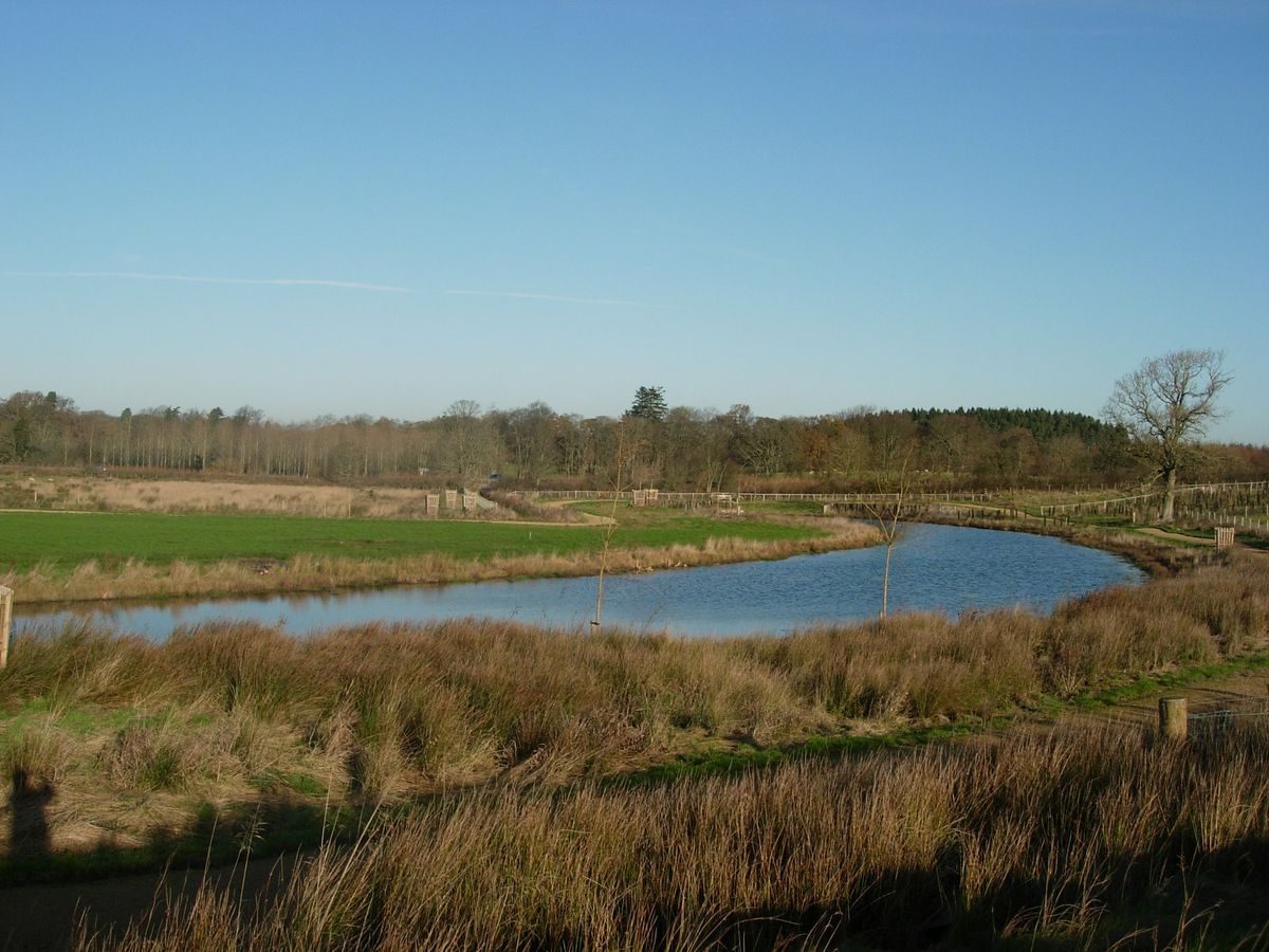
Kirkharle Hall has the remnants of landscape pleasure grounds and a park. The site is now divided into two roughly equal areas by the A696 road, built in the mid-19th century. The two areas are Little Harle Park (to the north) and Kirkharle Hall (to the south). Restoration work has recently taken place. A serpentine lake has been created in the early-21st century, based upon a plan by Lancelot Brown.
Terrain
Kirkharle lies in the Wansbeck valley.The following is from the Register of Parks and Gardens of Special Historic Interest. For the most up-to-date Register entry, please visit The National Heritage List for England (NHLE):
Parkland and remains of landscape pleasure grounds laid out 1718-43 by Sir William Loraine, second Bt, altered in the mid to late C18 by Sir William Loraine, fourth Bt and in the 1830s incorporated into the adjacent parkland of Little Harle. The Loraines' landscape works involved Lancelot Brown who worked on the estate, but the exact extent and nature of his involvement remains unclear.
Location, Area, Boundaries, Landform and Setting
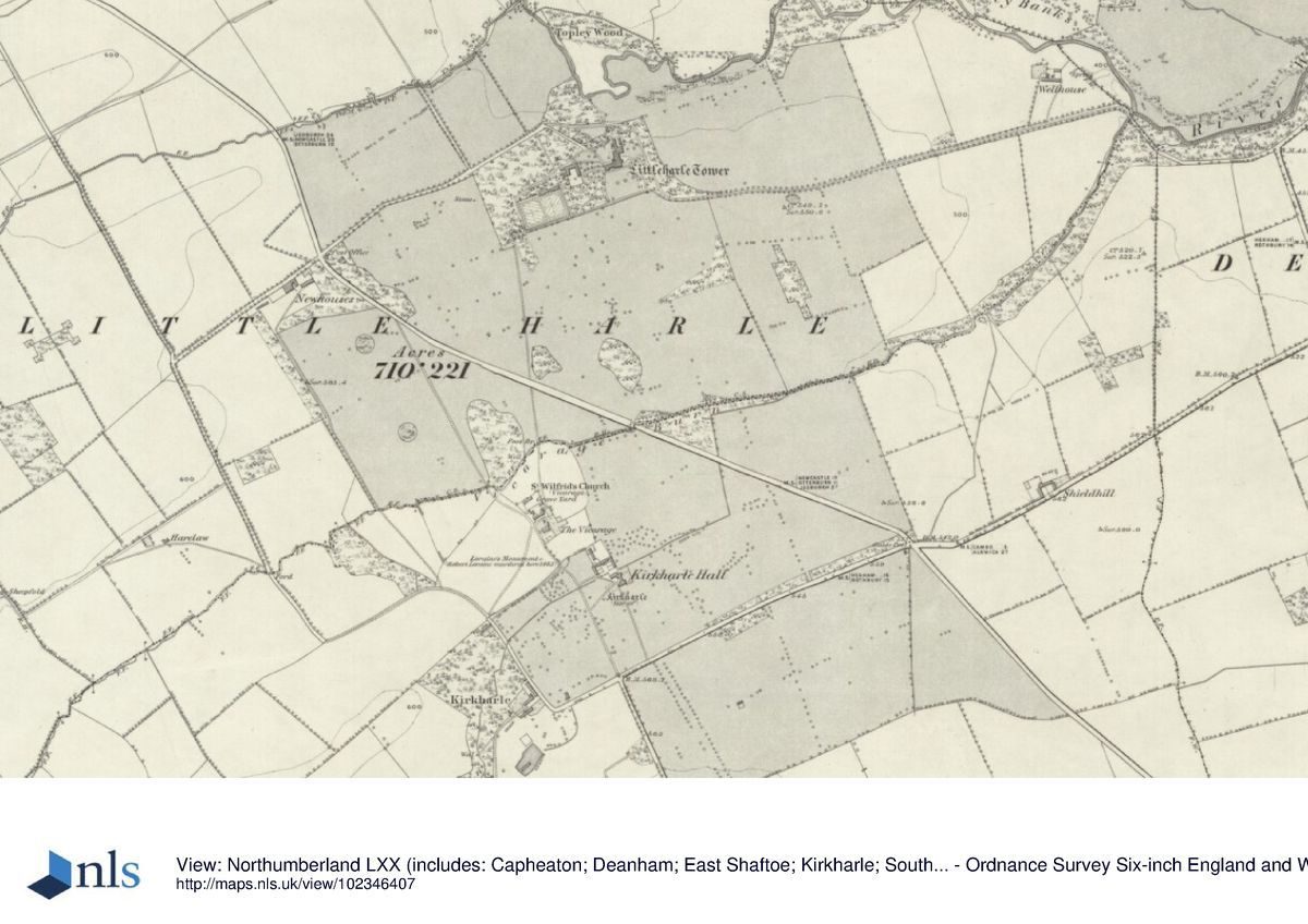
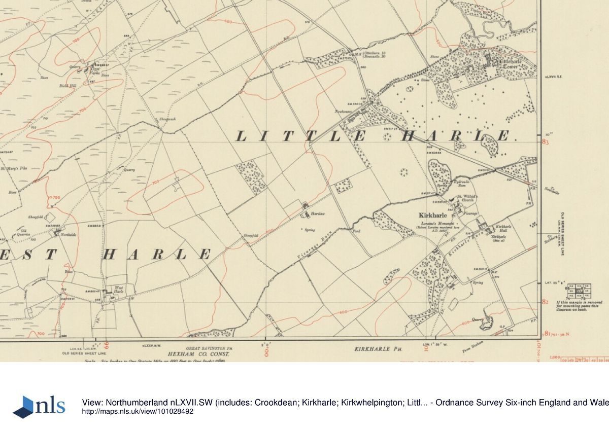
Kirkharle lies in the Wansbeck valley, immediately to the south of the A696, Newcastle upon Tyne to Otterburn road, and some 12km north-west of Belsay (qv). The registered area extends to some 80ha and includes Little Harle Tower park to the north.
The area is bounded on the north by an avenue leading from The Lodge, which lies on the east side of the A696 opposite Newhouses, to Little Harle Tower. On its east side the registered area is bounded by enclosure fields, the boundary running southwards to meet Vicarage Burn to the east of Kirkharle Bridge. Following the route of the A696 the boundary then takes in the area identified on the c 1763 'Brown' plan which centres on Kirkharle Farm.
The southernmost boundary follows the road leading off the Shielhill crossroads to Kirkharle and then turns northwards to include the field to the west of Kirkharle, which is the setting for the Loraine monument (1728, listed grade II), and incorporates the fields to the south of Newhouses. The Loraine monument commemorates a Loraine ancestor, 'Barborously Murder'd' by the Scots in 1483, as he was returning home from church, erected by Sir William Loraine, second Bt.
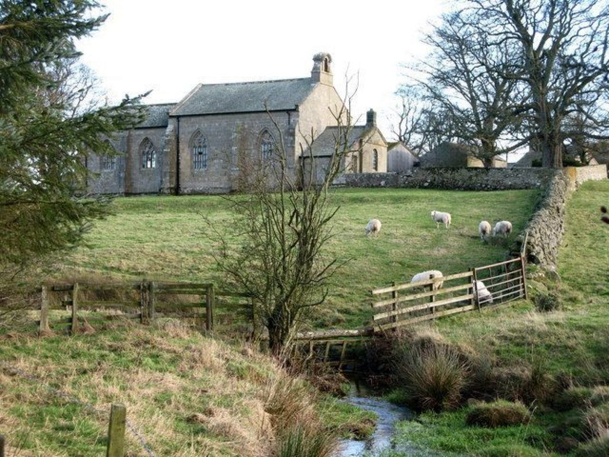
Two watercourses run across the area. Vicarage Burn flows eastwards and centrally across the site, through low-lying land to eventually join the River Wansbeck. Kirkharle Burn and a small stream in the north both flow parallel to Vicarage Burn and are its tributaries.
Entrances and Approaches
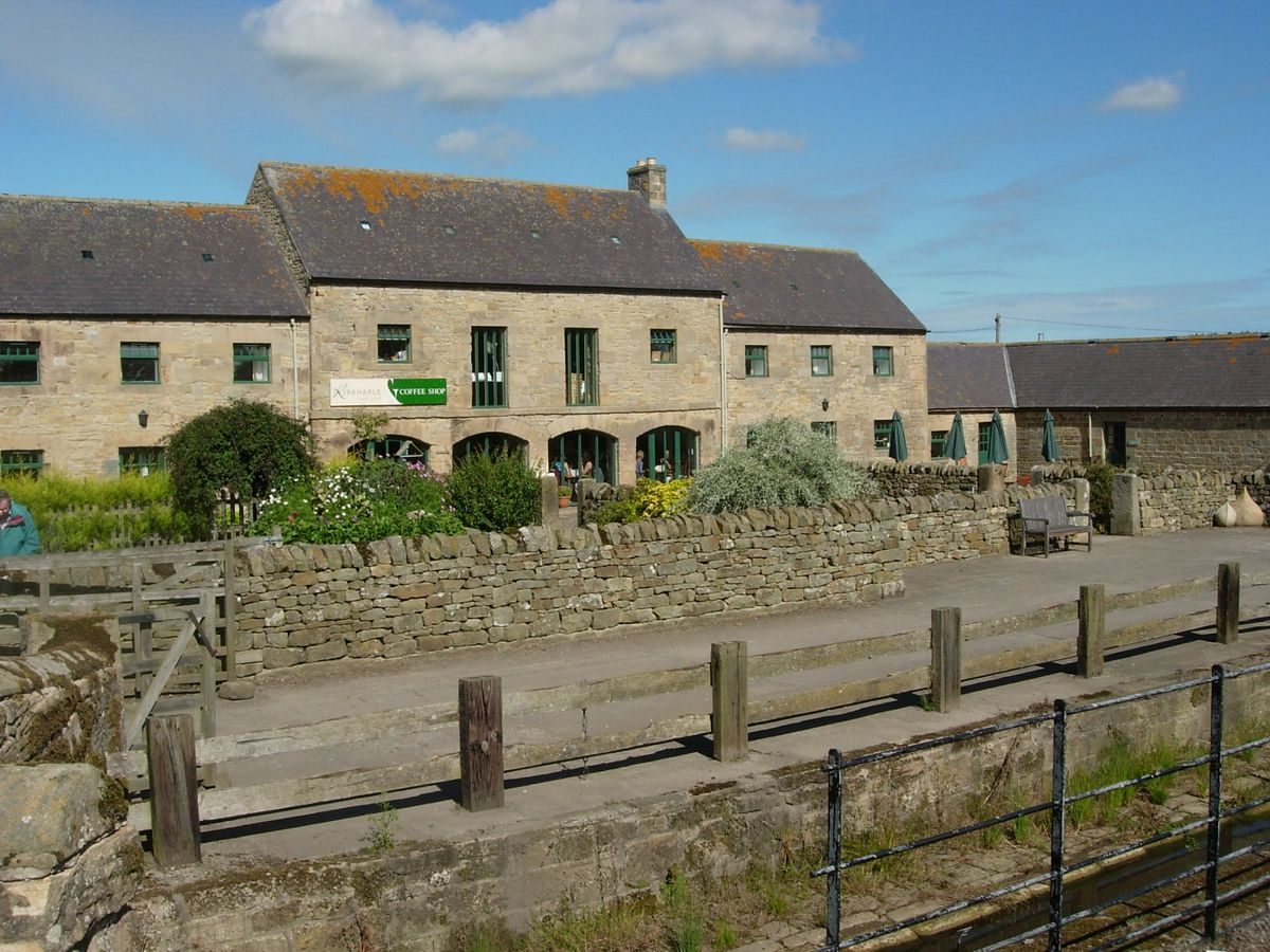
Kirkharle Farm (listed grade II) is the surviving east wing of Kirkharle Hall (initially built in c 1718, added to c 1755, and then partially demolished in 1836). Little Harle Tower (listed grade II*), 1km to the north (outside the area here registered), has a medieval core, with early C18 additions and a Victorian wing built 1861-2 by Thomas Anderson.
Park
The C18 parkland around Kirkharle Farm includes permanent pasture and arable dotted with many specimen trees, of oak, sycamore, and beech. There are the remains of the C18 shelter belts around Kirkharle Hall. To the south of the farm is a single beech tree, the remnant of a formal avenue focusing on Kirkharle Hall, a major part of which was still extant even by 1896 (OS). The shelter belts and beech all date to the second Bt's early, formal scheme. Large, circular roundels of trees survive in the field to the south of Newhouses.
Broadleaf woodland of 15ha surrounds Little Harle Tower, important in views from the south, from the A696, and important to the setting of Little Harle Tower itself. The parkland to the south of Little Harle Tower is scattered with individual mature trees and clumps. Some trees appear to remain from earlier field boundaries while others appear to have been planted as specimen trees; some are protected with stone cairns (as at Belsay Hall qv).
A variety of boundaries can be distinguished in the area. Medieval boundaries comprise drystone-faced earth banks originally topped with hedges. The C18 parkland boundaries are tree-lined or woodland perimeter belts, while the enclosure field boundaries are hedgerows, the principal species being hawthorn. A programme of repair and renewal of the boundaries started in the mid 1990s, with proposals to replant the landscape according to 'Brown's' plan (2000).
Maps
Armstrong, Map of Northumberland, 1769 (M55), (Northumberland Record Office)
Plan of Kirkharle attributed to Lancelot Brown, late 1760s, (Newcastle University)
Plan of the New Turnpike Road, 1830 (reproduced in Groundwork North East Ltd 1993)
Plan of the Estates of Kirkharle, Little Harle and Westharle, 1850 (reproduced in Groundwork North East Ltd 1993)
OS 6" to 1 mile:
1st edition surveyed 1860, published 1865
2nd edition surveyed 1896
Description written: January 2001 Amended: March 2003
Register Inspector: KC
Edited: July 2003
- Visitor Access, Directions & Contacts
Access contact details
http://kirkharle.tumblr.com/
Directions
http://www.kirkharlecourtyard.co.uk/directions.php
- History
The following is from the Register of Parks and Gardens of Special Historic Interest. For the most up-to-date Register entry, please visit The National Heritage List for England (NHLE):
18th Century
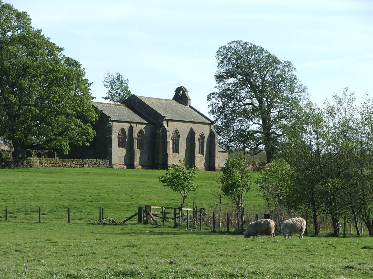
Kirkharle was a fairly large medieval settlement. The Loraines were landowners there as early as the C14. Sir William Loraine (1658-1743) succeeded to the Kirkharle estate as second Bt in 1718. Loraine, a London barrister, came of a prominent Northumbrian family; his maternal uncle was Sir John Fenwick of Wallington (qv). He himself became an important county figure, being elected MP in 1701. During his years at Kirkharle he transformed his estate, building 'a new mansion house of his own plan and contrivance, with all the offices, out-houses, gardens, fountains, fish ponds' (Hodgson 1827). He restored and refurbished St Wilfrid's church and 'planted between 1694 and 1738 of forest trees 24,000 and of quicksets above 488,000 and of fruit trees 580. He divided his lands, erected new farmhouses and buildings, drained the morasses and cleared the land of ponderous massy and hard stones to prepare for tillage' (Loraine 1902). This indicates that his farm reorganisation was accompanied by a period of intensive enclosure, the 488,000 quicksets representing at least 48km of new hedgerow (Groundwork North East 1993). His major estate reorganisation is probably the cause of Kirkharle village, which formerly stood immediately to the west of the Hall and its gardens (Armstrong, 1769), being rebuilt to a regular plan, further westwards.
Sir Charles Loraine, third Bt (1701-55) succeeded on his father's death and seems to have made few, if any changes. But in 1755 the succession of Sir William Loraine, fourth Bt (1749-1809) led to a period of considerable activity. He re-roofed the main part of Kirkharle Hall, adding two wings and an office range, and he removed his grandfather's formal gardens, although he retained the plantations sheltering the Hall.
19th and 20th Century
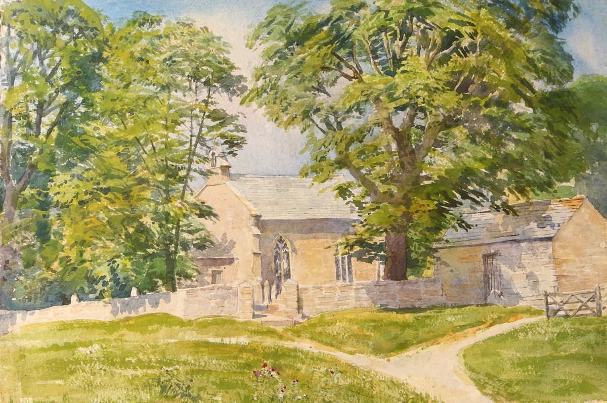
Hodgson, the early C19 county historian, is the authority who first connects Lancelot Brown (1716-83) with working for Sir William, after leaving school and before moving to the south of England in 1739. Brown was certainly born in Kirkharle in 1715/16, was baptised in St Wilfrid's in 1717 and attended school at Cambo, some 5km away until 1732, when he left to work on Loraine's estate (Hodgson 1827).
Again it is Hodgson who attributes some of these activities to Brown, but a later authority attributes the alterations to Sir William, the fourth Bt, stating that it was he who 'removed the fountains and gardens created under the advice of Brown', that is the works carried out during his grandfather's time (Loraine 1902). A plan attributed to Brown that survives certainly incorporates Brown's style of presentation and typical Brownian features and has been suggested to date to c 1763 (Garden Hist 1981). Among the proposals, not implemented, is the widening of the Kirkharle Burn to create a serpentine river winding east of Kirkharle Hall. This would also have drained a problematic low-lying area of land.
In 1836 the Loraine family sold Kirkharle Hall to their neighbour, Thomas Anderson of Little Harle Tower, who demolished the majority of the mansion, except for the east end which was converted into Kirkharle Farm. This was effected even though the building of the turnpike road to Edinburgh (the A696) in 1830 had severed Kirkharle park from that of Little Harle Tower to the north.
21st Century
The estate continues in private ownership and recently (2003) the office range and barn have been restored to provide a number of craft workshops, visitor facilities, and a Lancelot Brown interpretation centre.
- Associated People
- Features & Designations
Designations
The National Heritage List for England: Register of Parks and Gardens
- Reference: GD2051
- Grade: II
Features
- House (featured building)
- Description: Kirkharle Farm (listed grade II) is the surviving east wing of Kirkharle Hall
- Earliest Date:
- Avenue
- Description: An avenue leading from The Lodge, which lies on the east side of the A696 opposite Newhouses, to Little Harle Tower.
- Structure
- Description: The Loraine monument commemorates a Loraine ancestor, 'Barborously Murder'd' by the Scots in 1483, as he was returning home from church, erected by Sir William Loraine, second Baronet.
- Earliest Date:
- Latest Date:
- Burn
- Description: Vicarage Burn flows eastwards and centrally across the site, through low-lying land.
- River
- Description: River Wansbeck
- Lake
- Description: John Anderson, the current owner of Kirkharle, found a plan by Brown for a serpentine lake. It was decided to implement a version of this plan, making some amendments for the modern landscape context. Areas of logs and stones around the lake encourage breeding of insects, new woodlands have been planted and a cascade is planned for 2016.
- Earliest Date:
- Latest Date:
- Parkland
- Description: The C18 parkland around Kirkharle Farm includes permanent pasture and arable dotted with many specimen trees, of oak, sycamore, and beech.
- Key Information
Type
Park
Purpose
Ornamental
Principal Building
Commercial
Survival
Extant
Hectares
80
Open to the public
Yes
Civil Parish
Kirkwhelpington
- References
References
- {English Heritage Register of Parks and Gardens of Special Historic Interest}, (Swindon: English Heritage, 2008) [on CD-ROM] Historic England Register of Parks and Gardens of Special Historic Interest
- Stroud, D., {Capability Brown} (London: Faber, 1975) Capability Brown
- No 2 (1981), pp 159-66 Garden History 9
- (Tyne & Wear County Council Museums 1983), pp 11, 13, 41 Capability Brown and the Northern Landscape
- Capability Brown of Kirkharle
- pt 2 (1827 History of Northumberland 1
- Unpub PhD thesis, University of Cardiff 1975 Deserted and Shrunken Villages in Southern Northumberland from the 12th to the 20th Centuries
- unpub PhD thesis, University of Cardiff 1975 Country Life 183
- Pedigree and Memoirs of the Family of Loraine of Kirkharle
- Groundwork North East Ltd 1993 Kirkharle and Little Harle, Northumberland. Survey and Management Plan for a Historic Landscape