Introduction
Capheaton Hall has associated pleasure grounds and a landscaped park. Lancelot Brown may be responsible for the design of parts of the park.
Capheaton is a Wedding, Party & Event Venue and has occasional open days.
Terrain
The landscaped park occupies a south-facing slope cut midway by the How Burn, which crosses the park from west to east.The following is from the Register of Parks and Gardens of Special Historic Interest. For the most up-to-date Register entry, please visit The National Heritage List for England (NHLE):
Mid- to late 18th-century park and designed landscape incorporating features from a formal 17th-century layout.
Location, Area, Boundaries, Landform and Setting
Capheaton Hall lies 30 km north-west of Newcastle upon Tyne, to the south-west of the A696, Ponteland to Jedburgh road, and situated in a rugged stretch of Northumberland. The landscaped park of c 60 ha occupies a south-facing slope cut midway by the How Burn, which crosses the park from west to east, issuing from Sir Edward's Lake.
Entrances and Approaches
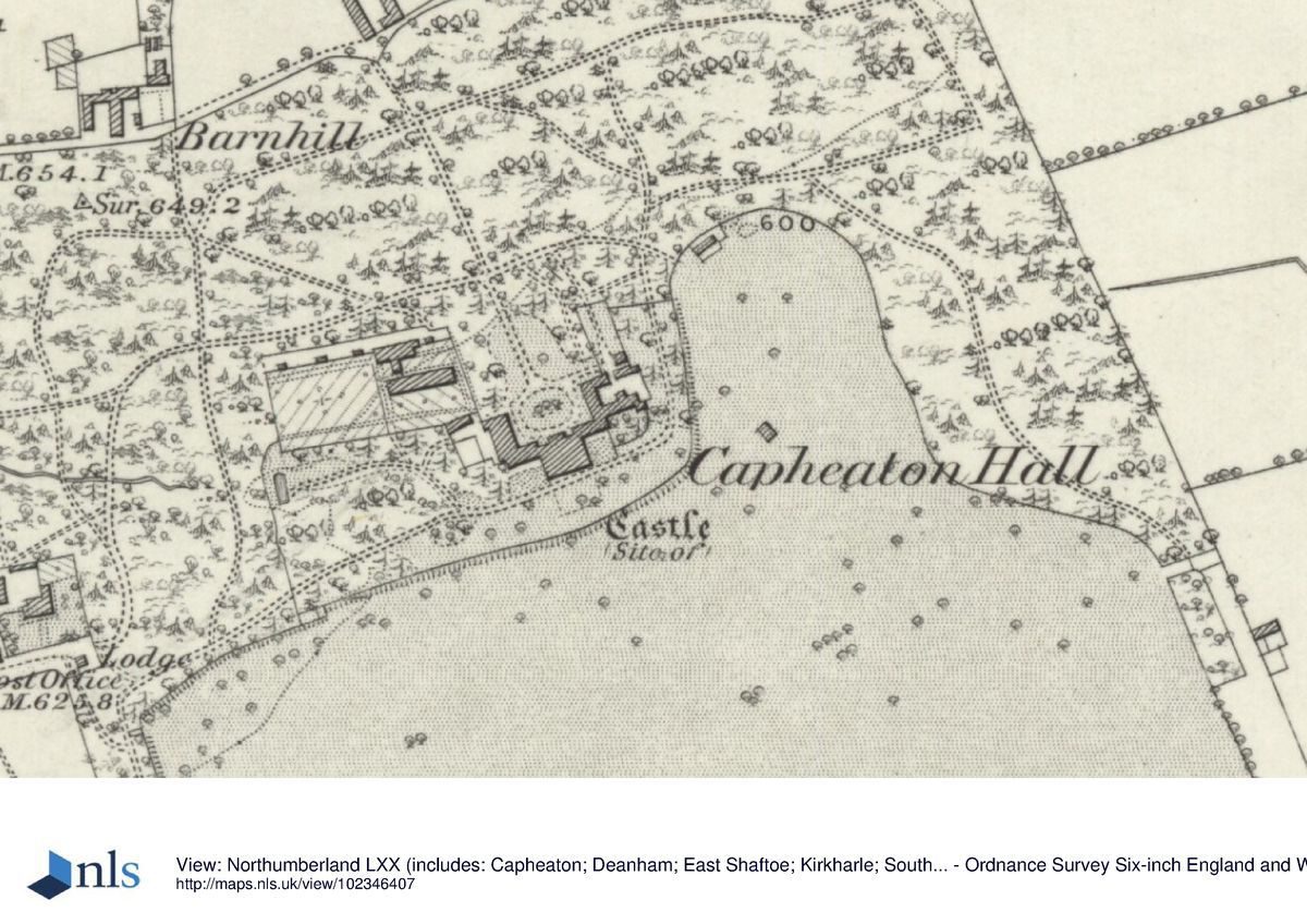
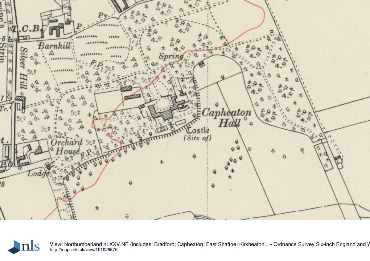
The East Lodge (listed grade II) is situated 1 km north-east of Capheaton Hall on the A696. It marks the entrance drive to Capheaton Hall and leads through the estate woodlands that shelter the north side of the Hall and its designed landscape. The drive curves gently to the north of the Hall, before turning to face the building and enter a forecourt set with a turning circle.
North of the Hall a second, cross drive runs east/west, bisecting this main drive. It leads eastwards to the north point of the park and westwards, past the walled garden to the West Lodge (William Newton late C18, listed grade II), 300 m west of the Hall. The West Lodge is situated at the east end of Capheaton village and to its north stands a pair of elaborately decorated gate piers (Trollope 1668, listed grade II*).
Principal Building
Capheaton Hall (listed grade I) was designed by Robert Trollope in 1668. Two wings, one on either side of the central block, were added for Sir Edward Swinburne (d 1786). Further additions include the north front, added by William Newton to designs by John Tasker in the late C18 for Sir John Swinburne. This classical addition has a three-bay pedimented centre and forms the main entrance front.
Gardens and Pleasure Grounds
A terrace, lying east/west, is situated on the south front of the Hall. It has two rectangular pools, each side of the main axis, built sometime after 1924 (OS 1925). The terrace looks southwards, over the park, from which it is separated by a ha-ha set c 30 m south of the Hall (listed grade II). A flight of steps leads down from the terrace through the ha-ha to the park.
A folly (listed grade II) stands some 150 m south-west of the Hall. This mid C18 structure is built as a ruined chapel with a Tudor-style doorway and a large gothic arched window in its east wall. A conservatory set against a garden wall (both mid C19 and listed grade II) stands 18m to the east of the Hall.
The pleasure grounds comprise 14 ha of wooded grounds crossed by informal paths, which lie to either side and north of the Hall. These are linked by the Lady's Walk leading through Park Strip, a perimeter belt forming the west boundary of park, to Hillhead Plantation on the south side of park.
Kitchen Garden
The kitchen garden lies 44 m to the north-west of Capheaton Hall. It is walled and built in brick, garden-wall bond (C18, listed grade II). In its south-east corner is a carriage house. A pair of gate piers are either side of the south central gate to the kitchen garden.
Park
The park extends over 60 ha, to the south of Capheaton Hall. It is surrounded by a perimeter belt and set with tree clumps, the largest being Litteragehill Wood. This lies directly to the south of the How Burn on a central axis with the Hall.
To the west of the park and Lady's Walk, which bounds the western perimeter of the park, is Lake Plantation. It in turn shelters the east side of Sir Edward's Lake. The lake extends to 15 ha and is set with two islands and, on its south-east bank, a boathouse.
A lane leads south from Capheaton village to Makemerich, parallel to the west park boundary. A formal tree-lined ride crosses this lane linking the park from Lady's Walk with Lake Plantation.
To the east of the park lies Boundary Plantation (outside the area here registered). Running north/south, parallel with Capheaton Park, it lies along the parish boundary and may mark the former extent of Capheaton Park. During the mid C19 (OS 1865), a formal drive led from the north front of Capheaton Hall to Home Farm, north of the Hall and outside the area here registered. This may have developed from a formal drive/axis of the C17 formal landscape.
To the west, at the top of the village, overlooking Sir Edward's Lake and outside the area here registered, stands a folly called the Dovecot (listed grade II) in the form of a cottage built so as to form a castellated tower.
Maps
- R Marshall, Plan of Capheaton Hall, 1761 (322 C6), (Northumberland Record Office)
- Armstrong, Map of Northumberland, 1769 (M55), (Northumberland Record Office)
- W Casso, Plan of Capheaton Hall, 1799 (Northumberland Record Office)
- OS 6" to 1 mile: 1st edition surveyed 1860, published 1865; 3rd edition surveyed 1924, published 1925
Description written: January 2001
Amended: March 2003; August 2003
Edited: July 2003
- Visitor Access, Directions & Contacts
Telephone
0191 375 8152Website
https://www.capheatonhall.co.uk/Access contact details
Capheaton is a Wedding, Party & Event Venue and has occasional open days.
Visit the National Garden Scheme website for more details and tickets for Open days.
Please telephone 0191 375 8152 for further details.
- History
The following is from the Register of Parks and Gardens of Special Historic Interest. For the most up-to-date Register entry, please visit The National Heritage List for England (NHLE):
17th Century
The Swinburne family had been rewarded with a baronetcy in 1661 for their support of the Royalist cause during the Civil War. Thus Sir John Swinburne re-established the family fortunes and, in 1668, commissioned the Newcastle architect, Robert Trollope, to build Capheaton Hall. Described as, 'One of the most interesting houses of its date and character in England' (Pevsner and Richmond 1957), Capheaton was completed in 1674.
A bird's-eye view of Capheaton, painted in that year by Peter Hartover, records the south, entrance front of the Hall and the formal 17th-century gardens (Harris 1979). The painting depicts the Loraines (see the entry on Kirkharle) visiting the Swinburnes. A formal walled forecourt was set against the south front of the Hall, with a pair of entrance gates leading out southwards onto the public road. The gates were decorated with carved trophies and led to the village, along an approach lined with 'Long avenues in the French taste, planted at the same time or later in the 17th century' (Harris 1979). To east and west of the forecourt and house lay formal walled gardens, laid into quarters with fountains and lawns.
18th Century
Writing in 1769, the Rev John Wallis mentions the Swinburne family landscaping their park (Wallis 1769). Traditionally, Lancelot Brown (1716-83) is credited with working at Capheaton, either in the landscaping of the garden immediately around the house or the lake (Tyne & Wear County Council 1983). An estate plan shows that clumps of trees were planted in the park by 1761 in the Brownian manner (Marshall, 1761). There is no documentary evidence however of Brown's personal involvement.
By the 1760s Capheaton Castle, the seat of Sir Edward Swinburne Baronet (died 1786), was set within a paled park. Already, by this date the lake known as 'Sir Edward's Lake', was laid out south-west of the park (Armstrong, 1769).
Major alterations to the Hall took place in the late 18th century, when there were additions to the north front and major landscaping within the park and estate lands. Capheaton village was also rebuilt as a model village, with terraces of houses facing south onto the main street and lining the main, west entrance route to the Hall (Casso, 1799; Pevsner and Richmond 1957).
The site remains (2003) in private ownership.
- Associated People
- Features & Designations
Designations
The National Heritage List for England: Register of Parks and Gardens
- Reference: GD2046
- Grade: II
Features
- Great House (featured building)
- Description: Capheaton Hall was built in the baroque style and replaced an earlier castle.
- Earliest Date:
- Latest Date:
- Gardens
- Description: A terrace, on the south front of the Hall. Has two rectangular pools
- Sham Ruin
- Description: A folly (C18 listed grade II) built as a ruined chapel with a Tudor-style doorway
- Parkland
- Description: 60ha, to the south of Capheaton Hall
- Kitchen Garden, Carriage House
- Description: Walled kitchen garden. It is walled and built in brick, garden-wall bond (C18, listed grade II). In its south-east corner is a carriage house.
- Conservatory
- Description: Conservatory (mid C19 and listed Grade II)
- Key Information
Type
Park
Purpose
Ornamental
Principal Building
Domestic / Residential
Survival
Part: standing remains
Hectares
60
Open to the public
Yes
Civil Parish
Capheaton
- References
References
- {English Heritage Register of Parks and Gardens of Special Historic Interest}, (Swindon: English Heritage, 2008) [on CD-ROM] Historic England Register of Parks and Gardens of Special Historic Interest
- Harris, J., {The Artist and the Country House} {London: Russell Chambers, 1979), p. 79 The Artist and the Country House
- Pevsner, N., J. Grundy and I. Richmond, {The Buildings of England: Northumberland} (London: Penguin, 1992), pp. 111-2 The Buildings of England: Northumberland
- (12 August 1965), p 390 Country Life 138
- Jones, B., Follies & Grottoes (1974) Follies & Grottoes
- Harris J., (1979), p 79 The Artist and the Country House
- (Tyne & Wear County Council Museums 1983), pp 11-14 Capability Brown and the Northern Landscape