Introduction
Formerly part of the grounds of Holland House, Holland Park incorporates the remains of 17th, 18th and 19th century park and gardens. The site was opened as a public park in 1952. It contains formal and informal gardens including grassed and woodland walks. Some remnants of the former estate's built structures remain in the park including its 19th-century Stable, Lodge, Ice House and elements of the landscaping and formal gardens are still visible, such as the Dutch Garden and Iris Garden, Lime Walk and woodland area. Over the years various sports and recreational facilities have been added, including an open air theatre, and a Japanese garden created in 1991.
Terrain
Holland Park rises from the south to a level plateau and drops steeply to the north and north-west.The present Park comprises only part of the large original estate, but most of the distinctive and notable features have been retained and restored where practicable. The unusual and charming formal garden adjoins the western end of the house and extends to the former Garden Ballroom (now the Belvedere Restaurant). It was created in 1812 by Buonaiuti, factotum to the Holland family, and was called the "Portuguese" garden until England's relations with Portugal deteriorated and it was renamed.
The garden consists of a geometric arrangement separated by paths which have probably been widened over the years. Along the north side runs an old creeper-covered brick wall, formerly part of the 17th century stables.
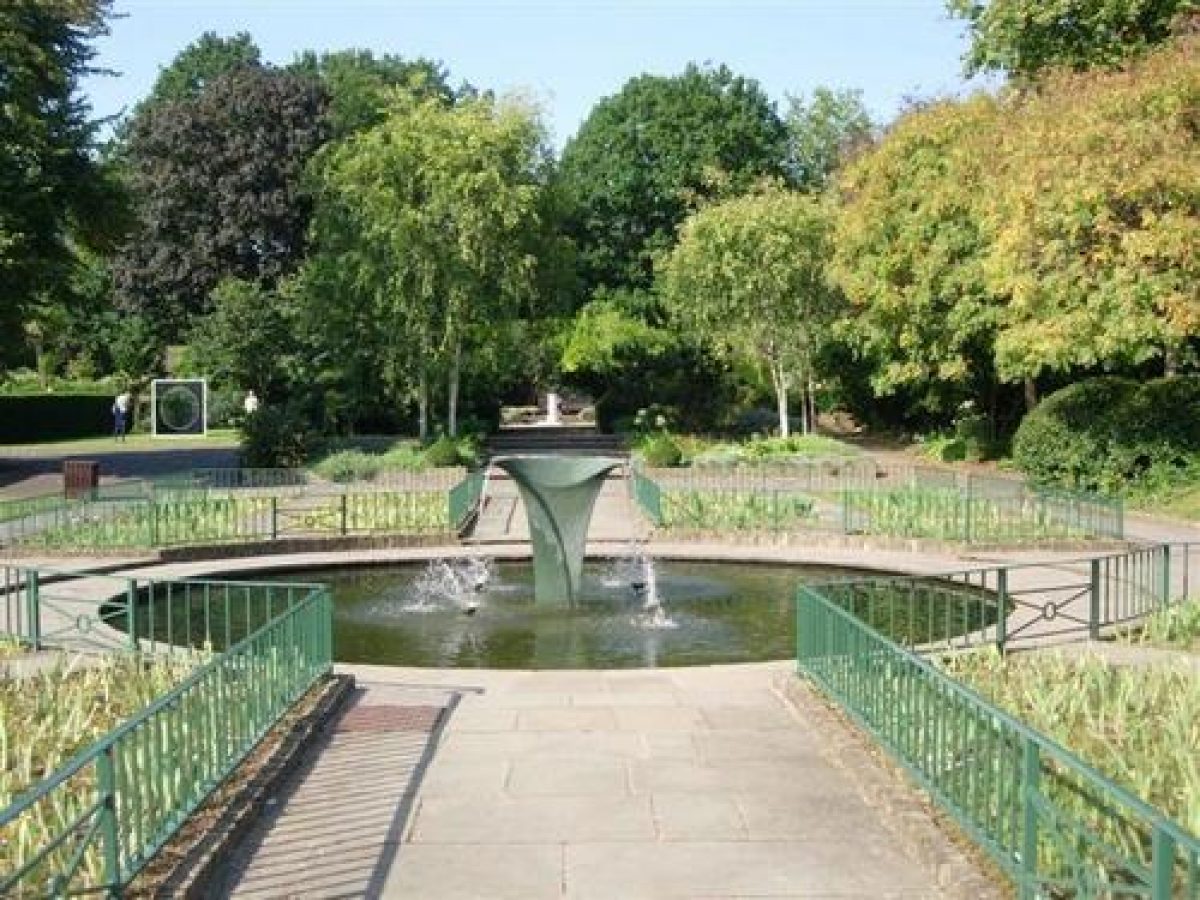
Through the adjacent arches is the site where the 3rd Lady Holland planted the first dahlia seeds to germinate successfully in England. Later they were grown in the Napoleon Garden and were re-introduced in 1992. The Iris Garden has an attractive pool with a new water sculpture which was added in 1999.
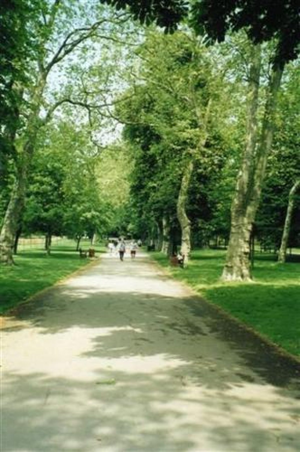
Leading from the north lawn to the woodlands is the former Rose Walk (now Azalea Walk) which Lady Ilchester planted with "Caroline Testout" roses in 1894. This variety is no longer in cultivation. The walk leads to a small pond and the statue of the 3rd Lord Holland. To the west of the pond is the Lime Tree Avenue, planted by the 4th Lady Holland in 1876. Many of the lime trees were destroyed in the gales of October 1987 and all have since been completely replaced.
The north entrance to the Park leads to the Sun Terrace. This was redesigned in 1988 to improve disabled access. It has a seating area amongst formal flower beds in three tiers, with a bird bath as the central feature of the terrace.
The main entrance in Kensington High Street has had its fine wrought-iron gates renovated with the Holland monogram restored. These 18th century gates were brought from Belgium in 1836 by the 3rd Lord Holland.
The following is from the Register of Parks and Gardens of Special Historic Interest. For the most up-to-date Register entry, please visit the The National Heritage List for England (NHLE):
www.historicengland.org.uk/listing/the-list
Pleasure grounds and parkland established by the early C18. In the mid C18 William Kent, and later Charles Hamilton, advised on the design and planting. The formal gardens were remodelled in the C19. Since 1953 the site has been managed as a public park.
DESCRIPTION
LOCATION, AREA, BOUNDARIES, LANDFORM, SETTING
Holland Park is located in Kensington, 5km west of central London and 0.75km to the south of Notting Hill. Kensington Gardens (qv) lie c 1.5km to the east, Earl's Court c 1km to the south, and Shepherd's Bush c 1km to the north-west. The c 22ha site is bounded to the north by the backs of houses along Holland Park road, while the boundary walls of properties to the east of Holland Walk provide the boundary to the east. Abbotsbury Road, formerly part of Holland Park, forms the boundary to the west. Planted by Charles Hamilton in the C18 it was known as the Green Walk (Haynes, 1770). The south boundary is formed by houses along Ilchester Place, Park Close, and Kensington High Street, and by the Commonwealth Institute (qv). The Commonwealth Institute (listed grade II*) was built in the mid C20 on the site of the sixth Lord Ilchester's golf school. Holland Park rises from the south to a level plateau and drops steeply to the north and north-west.
ENTRANCES AND APPROACHES
The main approach to Holland Park is from Kensington High Street to the south. The entrance is through ornamental iron gates brought from Belgium by the third Lord Holland and erected in 1836.The tarmac path, bordered by grass planted with regularly spaced plane trees, leads north along slightly rising ground for c 400m. To the west is open parkland, to the east is Holland Walk. In 1848 Lord Holland was given permission by the Law Courts to close the right of way across the south front of Holland House and in return he made a public right of way along the path which ran to the east of the entrance drive - what is now Holland Walk. After c 400m the path divides, the main branch continuing as the east perimeter path. There is a second major entrance from Ilchester Place to the south-west and a number of lesser entrances around the site, namely the Holland Park road entrance to the north; the Duchess of Bedford entrance to the east; and two from Abbotsbury Road, a pedestrian entrance to the south and a second to the north which leads past the late C20 adventure playground and on to a car park.
PRINCIPAL BUILDING
The south-facing Holland House (listed grade I) is situated on level ground on a high point in the centre of the site and consists largely of the three-storey east wing of the former mansion. The east-facing ground floor has an enclosed arcade with round-headed arches, the upper storeys being decorated with pilasters and shaped gables to a tiled roof. The east wing was restored and converted as a Youth Hostel in 1957 and additional accommodation blocks were added by the LCC at around the same time. In addition to the east wing, the shell of part of the main range survives. This has two bay windows flanking the polygonal porch, all reduced to a single storey. Single-storey stone loggias flank the centre block and continue around the wings, which come forward to enclose a raised terrace. The entrance porch is approached up stone steps from a grassed terrace divided into quadrants by paths. The terrace was, until the mid C20, decorated by a centrally place C19 fountain. An arcaded causeway (1890) links the House to the conservatory to the west.
Originally called Cope's Castle after Sir Walter Cope, the mansion was begun in 1605, the central block being completed by 1607. By the time of Cope's death in 1614 wings designed by John Thorpe had been added. The house was renamed Holland House after it passed to Cope's son-in-law, Sir Henry Rich, who became first Earl Holland in 1624. The account books for 1638-40 show that the first Earl built an extravagant range of stables and a coach house, much of which was demolished after 1796 (Allen et al 1992). The fourth Lord Holland spent much on Italianizing the House and Lord Ilchester, who took over the property in 1890, remodelled and enlarged the west wing and provided the arcaded causeway. The elaborate Jacobean mansion survived until it was badly damaged by enemy action during the Second World War and was largely demolished in 1955-7.
GARDENS AND PLEASURE GROUNDS
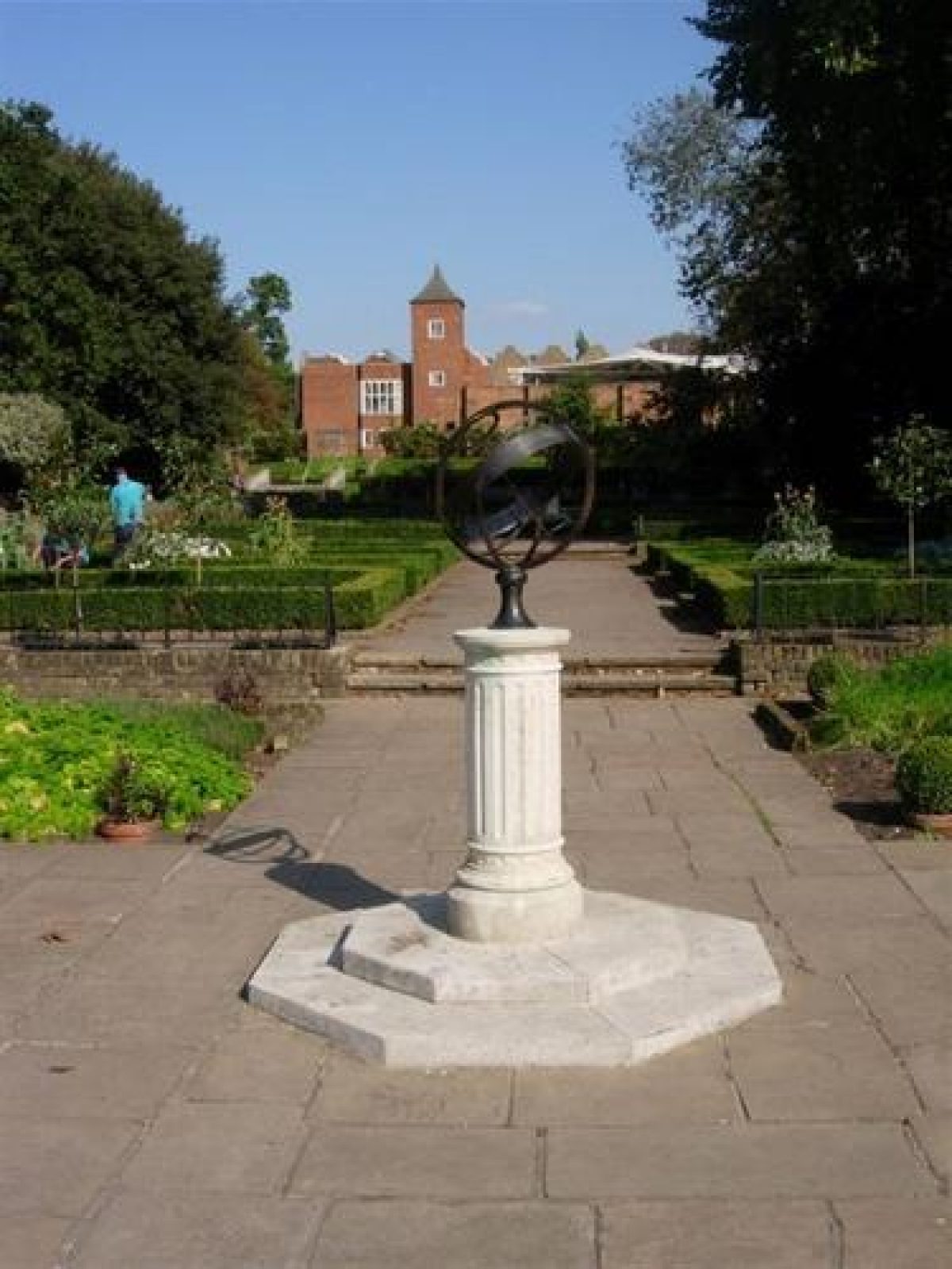
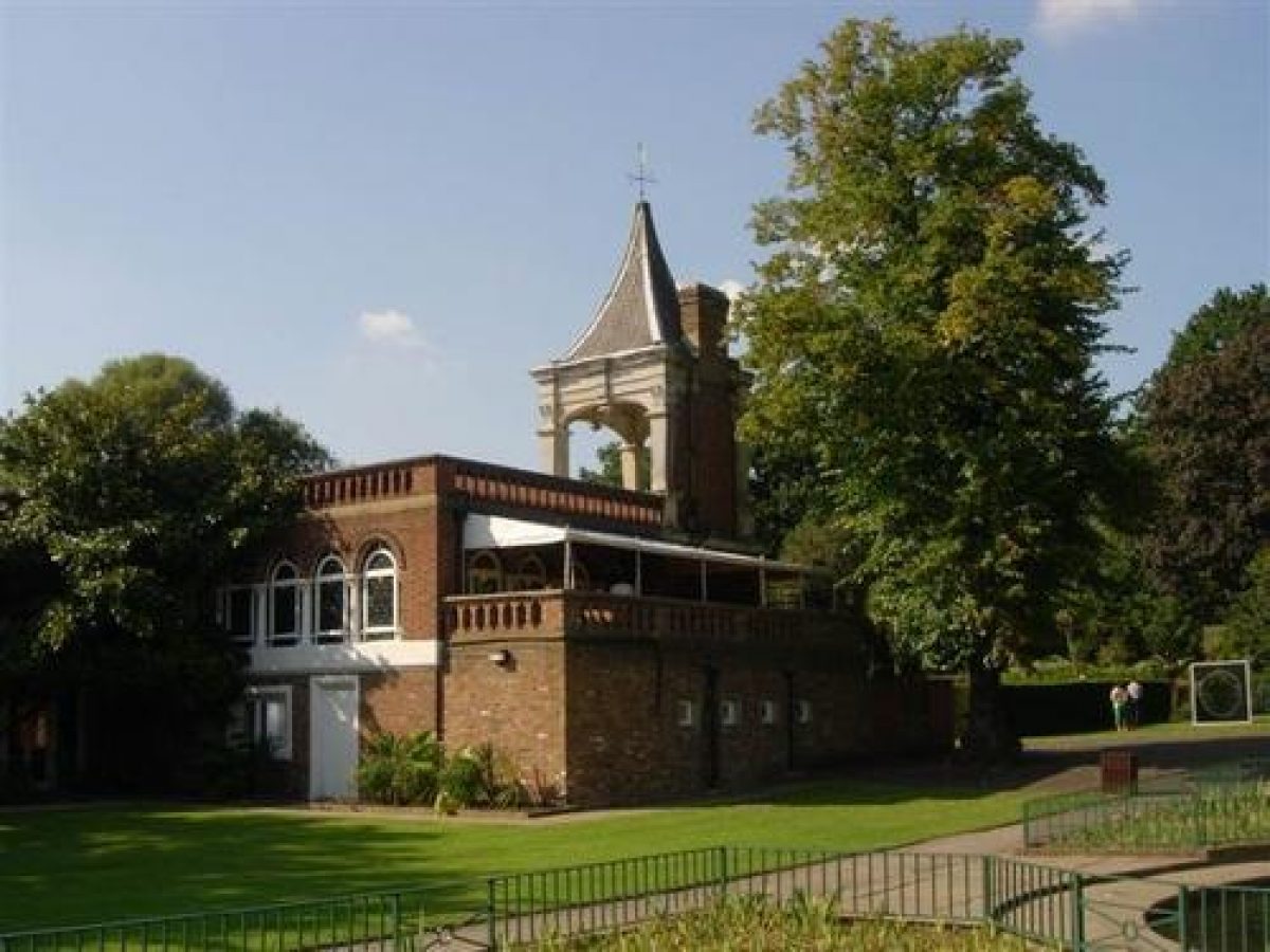
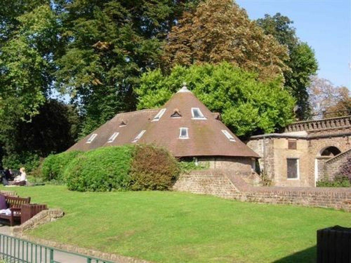
The gardens are made on level ground around the remains of the mansion with the pleasure grounds largely to the north. At the south-east corner of the former east wing, now the Youth Hostel complex, the southern approach path divides, the northern branch continuing north as a perimeter walk. The western branch, which was a right of way before 1848, runs east/west between the raised terraces to the south of the mansion and the sports field. The terraces are supported on the south side by brick walls topped by stone pilasters, the spaces between the pilasters being filled in with ornate terracotta medallions. Flights of steps lead up from the cross path to the level area in front of the House which is accessed through iron gates hung from Portland stone gate piers (c 1629, listed grade I). Attributed to Nicholas Stone after a design by Inigo Jones (Cherry and Pevsner 1991), the gate piers were moved here after the terrace was remodelled in 1847. The path continues to the west, passing the C20 cafe situated under the arcaded causeway to the north before dividing. To the south a branch leads to the Ilchester Place entrance passing, to the west, the C20 children's play area, where a lesser path runs across an area of sloping lawn with two C20 tennis courts and down to the Abbotsbury Road pedestrian entrance. To the north-west of this entrance is the plant nursery. A narrow strip of land between the path and the nursery is currently (1999) being made into a dry garden. From the arcaded causeway a second path leads west to the garden ballroom, a long brick and glass building orientated north/south with large arches on the west side. This building was originally part of the C17 stables and coach house, much of which was demolished after 1796, the remainder, reduced in width and lengthened to the south, being made into an orangery. The latter was converted into the ballroom in the mid C19 by J Browne and finished off at the north end with a neo-Jacobean belvedere, now (1999) a restaurant. To the north of the belvedere is a series of open arches, built from materials possibly originating from the C17 stables (Allen et al 1992). Enclosed within the arcades, the stable block, the belvedere, the garden ballroom and, to the east, a C19 icehouse (now used for exhibitions), are the formal gardens. The remains of C17 outbuildings form the boundary wall to the north. Part way along the wall is a small alcove with an ogee-arched entrance. This was formed in the C19 from part of the C17 harness-room fireplace. The formal gardens include, to the south, the rectangular early C19 Iris Garden with its circular pool and C20 fountain designed by William Pye, which replaced the C19 fountain in 1999. Rectangular beds in which the irises are grown surround the pool. To the north and east of the Iris Garden is the early C19 terraced Dutch Garden, laid out as a series of geometrical beds bordered by low box hedges. During the winter of 1813-14 refurbishment of the House and garden included a new parterre garden on the west side of the House. The third Lord Holland's Portuguese librarian Buonauiti was responsible for the design of the garden which was originally known as the Portuguese Garden. The name was changed to the Dutch Garden when, for political reasons, the Portuguese fell out of favour. The Garden was laid out in intricate scroll patterns and ornamented with a gilded astrolabe (replaced in the late C20) and two fountains (removed by mid C20). To the west of the open arches and the belvedere is a tarmac terraced area. The terrace, which overlooks an area of lawn to the east of the car park, was the site of Lady Holland's Dahlia Garden where, in 1805, she was credited with the first successful dahlia cultivation in England. The dahlias were subsequently moved into the Dutch Garden and Holland House became famous for them for the next fifty years.
A cross path runs east/west to the north of the northern boundary wall of the Dutch Garden, passing to the south of the north lawn and the C20 Arboretum before meeting up with the eastern perimeter path. The perimeter path continues north, around woodland enclosures separated by a system of paths, most of which were established by 1893 (OS). In 1770 the area to the north of the mansion was open parkland decorated with clumps of trees to the south and the degraded remains of the C17 formal Wilderness to the east (Haynes, 1770). The northern border was marked by the plantation, planted at the recommendation of Charles Hamilton, which spread into the Green Walk to the west. Like the Green Walk, most of Hamilton's northern plantation has been subsumed by residential developments. By the late C19 trees covered most of the parkland but remnants of the formal lines of the Wilderness could still be distinguished (OS 1893). The Arboretum is separated to the west from the adjoining block of woodland by the Azalea Walk, formerly (late C19) Lady Ilchester's Rose Walk. The Azalea Walk runs northwards from the north lawn and after c 100m meets with a major east/west cross path. A mid C19 seated statue of the third Lord Holland facing to the south marks the junction of the path. The cross path, which runs the width of the woodland enclosures, continues for c 100m where it divides. The southern branch runs for c 100m past, to the east, the Kyoto Garden. This Japanese garden was created in 1991 as part of London's Year of Japan festival and is situated on the site of an earlier Japanese garden made by the fifth Lord Ilchester (late C19). The branch path continues to the south-west, where it joins up with the northern cross path. The perimeter path and the woodland cross path gradually converge, the former becoming, for the last c 200m, the Chestnut Walk and the later Lime Walk. The Lime Walk was originally (1876) planted by the third Lady Holland and was replanted after the great storm of 1987. The perimeter path continues to the south-east for 150m, passing to the west the adventure playground before joining up with the northern cross path to the east of the car park.
PARK
To the west of the main entrance is the Commonwealth Institute. The 3ha of parkland between the Institute and the terraces to the south of Holland House is now (1999) made over as a sports field devoted to a variety of sports and enclosed within iron railings. In the late C17 the open parkland was divided by a formal avenue which led from the mansion to Kensington High Street (Bostock Fuller, 1694/5). By 1770 the avenue has been removed (Haynes, 1770).
REFERENCES
M R Gloag, A Book of English Gardens (1906), pp 219-40
C Holme, Gardens of England in Southern and Western Counties (1907), pp 77-81
J Macgregor, Gardens of Celebrities... in London (1918), pp 198-226
Earl of Ilchester, Chronicles of Holland House, 1820-1900 (1937), pp 481-503
Holland Park Management Strategy, (Royal Borough of Kensington and Chelsea 1986)
J Garden Hist 3, no 2 (1989)
B Cherry and N Pevsner, The Buildings of England: London 3 North West (1991), pp 479-81
D Denman, 'Poetry in Contemplation', The Independent on Sunday, 13 October 1991
I Allen et al, Holland Park, A Lost Perspective, (AA dissertation June 1992) [copy on EH file]
Maps
E Bostock Fuller, A Mapp of part of the Manors of Earls Court, Kensington and Abbots, 1694/5 (in Allen et al 1992)
J Haynes, Holland Park, Surveyed for the Right Honourable Lord Holland, 1770 (in Allen et al 1992)
Kensington within the County of Middlesex, surveyed 1694/5, redrawn with the additions by J Johnson and W Brother, 1794 (in Allen et al 1992)
Rhodes, Map of Kensington and Chelsea, 1766 (Kensington Library)
Survey of Metropolitan Sewers, 10ft to one statute mile, sheet 467, 1851 (Kensington Library)
OS 25" to 1 mile:
1st edition surveyed 1863-5
2nd edition published 1893
Description written: December 1999
Register Inspector: LCH
Edited: January 2002
- Visitor Access, Directions & Contacts
Access contact details
This is a municipal site for general public use. The park is open daily from 7.30am - dusk.
Directions
Tube: Holland Park (Central), High Street Kensington (District, Circle). Bus: 9, 9a, 10, 19, 27, 28, 31, 49, C1
Owners
The Royal Borough of Kensington & Chelsea
- History
The following is from the Register of Parks and Gardens of Special Historic Interest. For the most up-to-date Register entry, please visit the The National Heritage List for England (NHLE):
www.historicengland.org.uk/listing/the-list
HISTORIC DEVELOPMENT
By 1610 Sir Walter Cope, a favourite of King James I, had acquired all four manors that made up Kensington: St Mary Abbot's, Earl's Court, West Towne, and Knotting Barns (Notting Hill). He built a new house, Cope's Castle, on the south-facing slope of a hill that was part of the manor of St Mary Abbot's. When his widow remarried, the property reverted to his daughter Isabel who was married to Sir Henry Rich, later Baron Kensington (1622/3), and first Earl Holland (1624). He renamed the mansion Holland House. There is little documentary evidence for the development of the garden around Holland House in the second half of the C17 (Allen et al 1992). The Royalist Henry Rich was beheaded in 1649 and Holland House confiscated; for a short while it was used as headquarters for the Parliamentary Generals Fairfax and Lambert. Robert, second Earl of Holland reclaimed the estate in 1655. A survey of the Kensington property of Edward, third Earl of Holland commissioned from Edward Bostock Fuller in 1694/5 shows an estate of almost 202ha, bounded to the north by Uxbridge Road and stretching south-east in a long finger of land reaching nearly to the Fulham Road. The formal Wilderness to the north of Holland House is shown for the first time on this plan.
The third Earl died in 1701 and in 1716, after a long friendship, his widow Charlotte married Joseph Addison, one of the foremost promoters of the landscape garden. Addison only lived at Holland House for three years before he died in 1719. The Holland title died out in 1721 when the fourth Earl died. The estate then passed to a cousin, William Edwards, created Lord Kensington in 1776. In 1746 Henry Fox took a lease on Holland House and thus began its association with one of the most powerful of the Whig dynasties of the C18 and C19. Henry Fox set about improving the parkland surrounding Holland House, consulting first, in 1747, William Kent and later, between 1750 and 1756, his friend Charles Hamilton of Painshill Park (qv) who advised on the landscape, and Peter Collinson who advised on the planting. In 1763 Henry Fox was created Baron Holland of Foxley and five years later an Act of Parliament confirmed the contract for the sale of Holland House to him. The first and second Lords Holland died in quick succession and when the third Lord and his wife took up residence at Holland House in 1797 they set about renovating the property. Holland House became the centre of a glittering social, literary, and political circle. During the same period building development outside the estate accelerated.
The mid C19 saw Holland House decline into relative obscurity with the widowed Lady Holland spending most of her time either abroad or at her other properties, only returning to live at Holland House for the last years of her life. A year after the Countess' death in 1845 the fourth Lord and Lady Holland returned from Italy where they had lived for the past thirteen years. The following year they started a programme of repairs and alterations to the house, J H Brown, already employed by the estate, taking on the responsibility of architect and surveyor. A new carriage forecourt was made to the east side of the House, the excavated material being used to make terraces on the south front. After the death of the fourth Lord Holland in 1859 Lady Holland continued her extravagant lifestyle, selling off plots of land for development when she experienced a deficiency in her annual budget. In 1869 Lady Holland made the fifth Lord Ilchester, a distant relative, her heir and in 1874 documents were signed leaving Holland House and other property to him. Lady Holland continued to live in Holland House and by the time of her death in 1889 the House was in great need of repair. Lord Ilchester then undertook a programme of renovations. After he died in 1905 his widow continue to live at Holland House for the next thirty years, during which time the garden gained a reputation for being one of the finest in England. The general public were given the opportunity to enjoy it when occasional fetes, fairs, and flower shows were held there. On the death of his mother in 1935 the sixth Lord Ilchester took on responsibility for Holland House but was faced with continuing financial problems. A small golf school was established on land to the south and a housing scheme on Abbotsbury Road was extended. In September 1940 Holland House was severely damaged by a number of firebombs dropped during enemy action. Between 1945 and 1953 protracted negotiations for the sale of the estate took place between Lord Ilchester and the London County Council. An Act of Parliament in 1953 eventually bought this to fruition and part of the grounds was opened to the public later that year. The Royal Borough of Kensington and Chelsea took over the site in 1986 and after consultation a management plan was put in place. The site remains (1999) in their ownership and is managed as a public park. The shell of part of the main house is currently used as a backdrop for open-air performances. The east wing was restored and converted as a Youth Hostel in 1957.
- Associated People
- Features & Designations
Designations
The National Heritage List for England: Register of Parks and Gardens
- Reference: GD1805
- Grade: II
The National Heritage List for England: Listed Building
- Reference: Entrance on High Street Kensington
- Grade: II
The National Heritage List for England: Listed Building
- Reference: Holland House
- Grade: I
Features
- Building
- Description: Remains of Holland House
- Arcade
- Artefact
- Description: ceramic tiles
- Artefact
- Description: murals
- Orangery
- Tower
- Planting
- Description: Japanese garden
- Waterfall
- Pond
- Statue
- House (featured building)
- Partly Ruined
- Description: The house was gutted by fire in 1940, though the east wing is now converted to a youth hostel.
- Earliest Date:
- Latest Date:
- Gate
- Description: Entrance is through ornamental iron gates brought from Belgium by the third Lord Holland and erected in 1836.
- Latest Date:
- Key Information
Type
Park
Purpose
Recreational/sport
Principal Building
Parks, Gardens And Urban Spaces
Survival
Extant
Hectares
19.47
Open to the public
Yes
- References
References
- {Engilsh Heritage Register of Parks and Gardens of Special Historic Interest} (Swindon: English Heritage 2008) [on CD-ROM] Historic England Register of Parks and Gardens of Special Historic Interest
- Cherry, B. and Pevsner, N. {The Buildings of England: London 3: North West} (London: Penguin, 1991) pp 479-481 The Buildings of England: London 3: North West