
Introduction
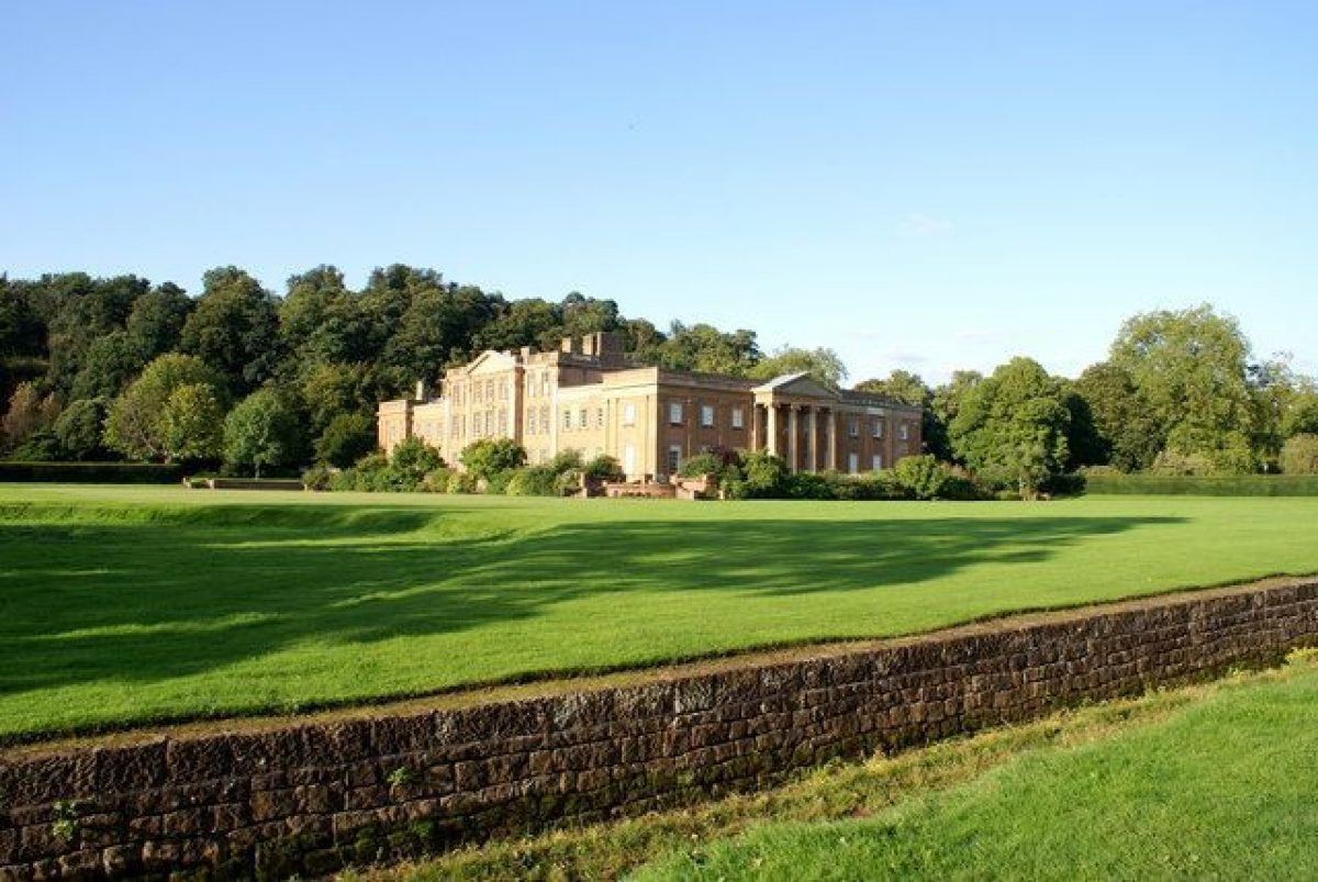
Himley Hall is a landscape park and pleasure grounds laid out in the mid-18th century. The grounds surround a country house, possibly by Nathaniel Richmond, and extended in the 1770s by Lancelot Brown. The site covers 205 hectares.
The following is from the Register of Parks and Gardens of Special Historic Interest. For the most up-to-date Register entry, please visit the The National Heritage List for England (NHLE):
www.historicengland.org.uk/listing/the-list
A landscape park and pleasure grounds laid out in mid C18 around a country house, possibly by Nathaniel Richmond, and extended in 1770s by Lancelot Brown and in 1820s by William Atkinson. It incorporates a medieval deer park.
DESCRIPTION
LOCATION, AREA, BOUNDARIES, LANDFORM, SETTING
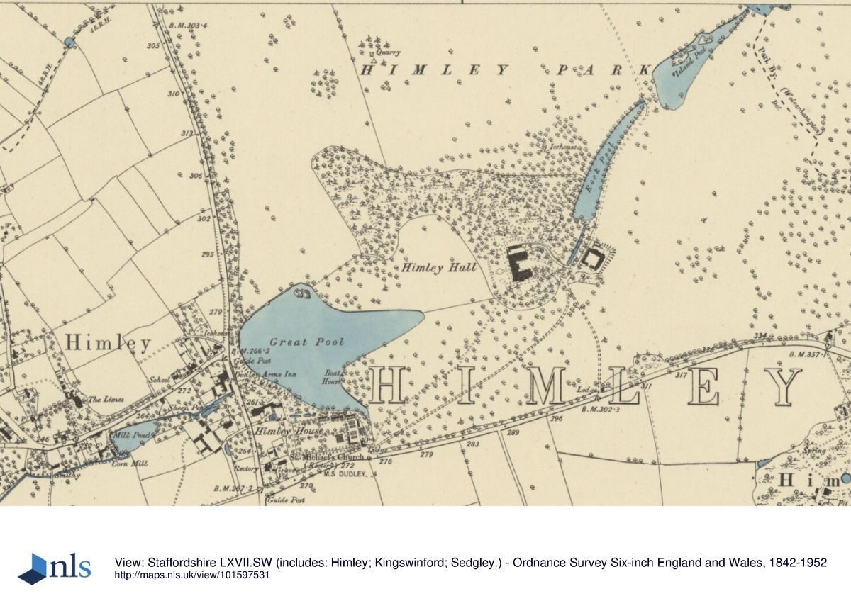
Himley Hall is on the north side of the B4176, 1.5km north-east of the village of Himley and 5km west of Dudley. To the west the site is bounded by the A449 from Stourbridge to Wolverhampton. The Hall stands surrounded by parkland and protected on its northern side by a sandstone outcrop known as The Hill. Its main views are to the west and south. The area here registered is c 205ha.
ENTRANCE AND APPROACHES
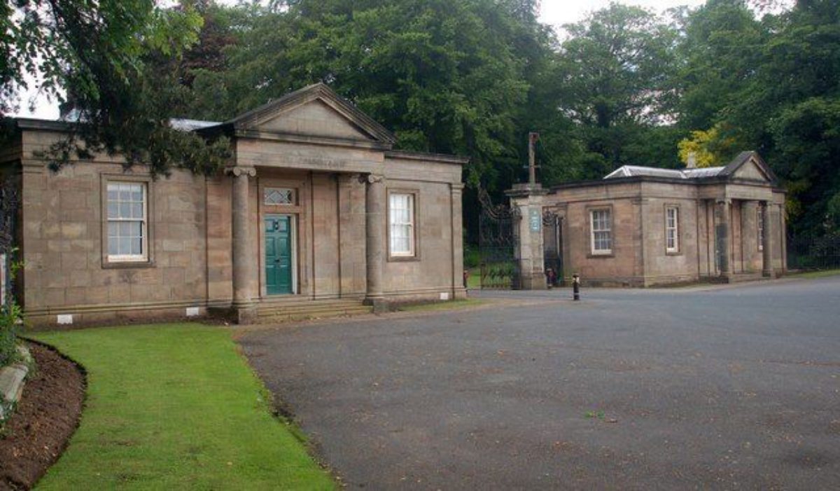
The two present entrances to the Hall are both off the Dudley Road which forms the southern boundary of the site. A lodge and gates (listed grade II), altered to their present appearance around 1875, stand at the south-western corner of the park. From here, the drive leads east across the park, joining up with that from the double lodges south of the Hall, to arrive at the east front. The second entrance south of the Hall is marked by a pair of lodges (listed grade II), the drive leading northwards to join the south-western approach. Both drives have been planted up with limes in the C20. A third drive links north to Park Farm. In the late C18 it formed the main scenic approach to the Hall but this arrangement was altered when William Atkinson erected the new stable block to the east of the Hall in the 1820s.
PRINCIPAL BUILDING
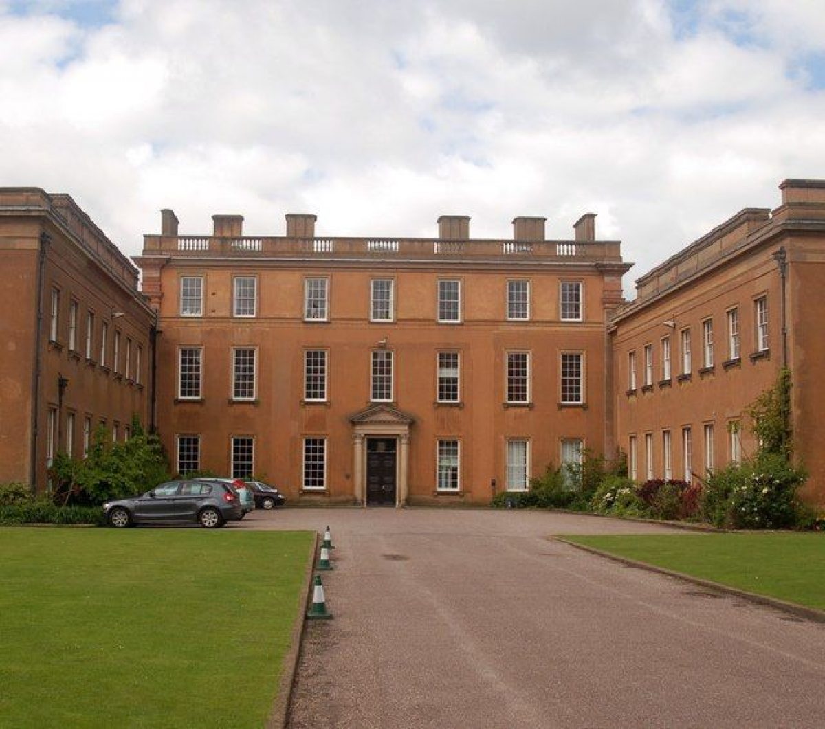
Himley Hall (listed grade II*) is an early C18 ashlar building, enlarged 1824-7 by William Atkinson (d 1839). The main range is north/south; Atkinson added flanking wings to this, attached by short links to produce a U-plan structure around an eastern courtyard. The main, west, seven-bay front has an early C18 central block of three storeys with a balustraded parapet and giant pilasters at the corners and to each side of a three-bay pedimented projection.
GARDENS AND PLEASURE GROUNDS
Below the south and west fronts of the Hall is a brick terrace, which, like the tennis courts, was constructed in the 1930s for Lady Ednam. It was originally laid out with paving and herbaceous borders. Beyond lies levelled lawns, divided from the park by a ha-ha.
A path leads from the Hall to the foot of the eastern end of The Hill where the natural sandstone rock face is used as a romantic feature, a cave with a crude gothic entrance being cut into its base. The Hill, a steep and wooded rocky outcrop to the north of the Hall, was laid out with paths according to Brown's proposals, to form a pleasure ground from which there were views out over the north park. When first laid out the pleasure ground extended further into the Park Farm area. It is fenced off from the park along its northern edge by an iron deer fence, the gates through which line up with the traces of a path system, apparently developed by Atkinson from Brown's more simple network.
At the foot of the south face of The Hill, north of the Hall, is an icehouse with a long ice-shute leading down into it. This is the old icehouse, presumably of mid C18 date, which was reworked when the new icehouse which stands in the north park was constructed, probably to the designs of William Atkinson, in the early C19. The shute was added at this time with ice presumably being transferred from the more efficient new house for temporary storage in the old house where it was more convenient for use. It seems likely that Atkinson was also responsible for the gothic bridge and underpass on Piper's Hill, at the south-western corner of the pleasure grounds. The plantings of conifers and exotics in the pleasure ground were put in by the Dowager Lady Ward in the mid to late C19.
PARK
To the south the park is defined by the Dudley Road, moved to its current line in the late C18 to accord with Brown's plans for the expansion of the park. This involved the clearing of a small hamlet and the re-routing of the road south of St Michael's Church to give space for the intended kitchen garden and farmyard, the original road becoming a drive. The park wall along the southern boundary was presumably removed as part of the road-widening exercise in 1930.
Stourbridge Road forms the western boundary of the site and the parish boundary that to the north. Both were screened by an informal belt of trees, planted by Brown, which incorporated Hawkswell Rough, an existing copse, and merged into Woody Park, also an existing piece of woodland and now a mature conifer plantation. To the east, the park wall runs between the dismantled railway and High Arcal Road. A section of the wall in the valley north of Spring Pool was demolished, along with an embankment carrying a driveway, as part of the reclamation work carried out in the 1980s in connection with the Baggeridge Country Park.
The north park which surrounds Park Farm has now mostly been ploughed up, but even as laid out in the C18 was sparsely planted to allow of long open views from the walk round The Hill. Two of Brown's main clumps were planted as suggested on prominent positions on the crest of the ridge, whilst the third was moved to take more advantage of the existing topography. This is the oldest area of the park, having been created around 1200 as a private deer park, and Park Lodge originally served as the head keeper's house. The line of monkey puzzles which leads north from the Lodge was planted in the mid C19 during the Dowager Lady Ward's occupancy of the Hall. A new house, The Demesne, has recently (late C20) been built in the north-west half of the area.
The park to the east of the Hall, the main area worked on by the first Viscount in the late C18, was cut across by a mineral railway on an embankment in c 1903. The land to the west of the line was laid out in the 1970s as the Himley Golf Course, whilst the rising land to the east survives as parkland, and shows evidence of the early approach drive linking the Hall to Straits Farm (now gone). It seems likely that 'The Woodlands', a picturesque cottage standing in the south-east corner of the site, was built by Atkinson as an eyecatcher for the grounds.
A chain of ponds runs from the north-east to south-west across the site, following the line of a natural water course. The northernmost of the ponds within the park is Spring Pool. This is divided by a weir from Island Pool, in turn divided from Rock Pool by a rocky cascade and a rusticated ashlar stone bridge (listed grade II) carrying the back drive. The water then falls over a weir into a canal which leads through the pleasure grounds at the base of The Hill, and is conducted underground before re-emerging at the Great Pool which dominates the south-west corner of the park. The series of pools to the east of the Hall possibly formed part of Richmond's scheme, although the cascades which divide the pools, and the bridge, were probably the work of Atkinson. The Great Pool was a later addition and the work of Brown, created by the construction of a large dam at the western end of the park. As part of these improvements, Brown excavated and reshaped the ground to accentuate the view of the new lake from the western front of the Hall, and remodelled Piper's Hill.
KITCHEN GARDEN
The kitchen garden occupies the south-west corner of the site, the site put forward by Brown, and is currently (1999) used for a model village and miniature railway enterprise. Traces of the once extensive range of glass remain but in poor repair. By the parish church, rebuilt in 1764 by the first Viscount Ward, is a private burial ground, laid out as a Memorial Garden by Lady Ednam following the death of her son, proposals for its design being supplied by G H Kitchen, architect, of Winchester.
REFERENCES
W Pitt, General View of Agriculture of Stafford (1796), p 94
S Shaw, History of Staffordshire II, (1801), pp 223-34
D Stroud, Capability Brown (1975), p 154
Himley Hall, Historic Landscape Survey, (Colson Stone Partnership 1993)
Maps [all reproduced or cited in Colson Stone 1993]
F Richardson, Survey, 1752
A plan of the alterations at Himley Hall, c 1760, attrib Nathaniel Richmond
Harry Court, A plan of Part of the Parish of Himley, 1778/9
Lancelot Brown, Plan of Part of Himley in Staffordshire, 1779
J P Roberts, Plan of Park of Lord Dudley's Park, 1816
Billingsby Morris, Dudley, Plan of the Parish of Himley, 1826
Plan of the Parish of Himley, 1841
OS 1" to 1 mile: 1st edition published 1834
OS 25" to 1 mile:
1st edition published 1886
2nd edition published 1903
3rd edition published 1919
Description written: March 1999
Register Inspector: PAS
Edited: September 1999
- Visitor Access, Directions & Contacts
Telephone
01384 817817Access contact details
The hall is open between April and September. For further details see:
Owners
Dudley Metropolitan Borough Council
Council House, Priory Road, Dudley, West Midlands, DY1 1HF
- History
The following is from the Register of Parks and Gardens of Special Historic Interest. For the most up-to-date Register entry, please visit the The National Heritage List for England (NHLE):
www.historicengland.org.uk/listing/the-list
HISTORIC DEVELOPMENT
The Hall was recorded in the register of the Bishop of Coventry and Lichfield in 1361 and by the mid C17 there was a moated manor house. In the later half of the C17 this became the seat of Lord Dudley, and land was purchased to consolidate the estate. John Ward, sixth Baron, created Viscount Dudley and Ward in 1763, inherited the estate from his cousin in 1740, and at once set about building a new house, choosing a new site slightly to the north and east of the existing moated one. The moat was initially retained as the most westerly of a chain of fishponds which extended up the valley to the south and east of the new house. Ward also called in a landscape improver to prepare proposals for the grounds who, from the style of the plan which has survived, would seem to have been Nathaniel Richmond (Colson Stone 1993). His contribution was mostly on land to the north of the new house, the area to the south being restricted by a road.
When the second Viscount inherited on the death of his father in 1774, he at once called in Lancelot Brown (1716-83) and embarked on a series of developments to expand and improve the estate. Brown's surviving plan is dated 1779, and covers the Old Park area north of The Hill, but also the land south of the Hall. At least some of his proposals were carried out including his recommendation for realigning the Himley to Dudley Road.
On the death of his father in 1823, William, cousin of the second Viscount, inherited Himley and became the fourth Viscount. He commissioned William Atkinson to redesign the Hall which, between 1824 and 1827, was extensively remodelled, and a new brew and wash house was built to the north of the Hall and a stable block to the east on the site of the earlier kitchen garden. Atkinson had experience in landscape work and he was also responsible for improvements to the grounds at Himley.
On the death of the fourth Viscount in 1833, Himley passed to his second cousin, the Rev William Humble Ward. He died in 1836 and was succeeded by his son William, aged sixteen. In 1838, William purchased the Witley Court estate and made this his principal residence. Himley became the home of his mother, Amelia, the Dowager Lady Ward, until her death in 1882. Lord Ward died three years later and the estate passed to his eldest son, the second Earl, who came of age in 1888. In 1919 the second Earl transferred his estate to his son, Viscount Ednam, who after the First World War moved into the Hall which, refurbished in the early 1920s, once again became the chief residence of the family. This proved a brief return since during the Second World War the property ceased to function as a private house and was used as a hospital. Then, in 1947, the third Earl sold the Hall, along with 81ha of parkland, to the National Coal Board. In 1967 the Hall and 73ha were purchased by Dudley and Wolverhampton councils for use as a teachers' centre, and the park was opened to the public. In 1988 Wolverhampton sold its share to Dudley MBC which remains the principal owner (1999).
- Associated People
- Features & Designations
Designations
The National Heritage List for England: Register of Parks and Gardens
- Reference: GD2289
- Grade: II
Features
- Lake
- Waterfall
- Description: Series of waterfalls.
- Pet Cemetery
- Description: Earl of Dudley's dog cemetery.
- Icehouse
- Ha-ha
- House (featured building)
- Description: The house was extensively re-modelled in the 1820s, and refurbished in the 1920s.
- Earliest Date:
- Key Information
Type
Park
Purpose
Recreational/sport
Principal Building
Parks, Gardens And Urban Spaces
Survival
Extant
Hectares
205
Open to the public
Yes
Civil Parish
Himley
- References
References
- {English Heritage Register of Parks and Gardens of Special Historic Interest}, (Swindon: English Heritage, 2008) [on CD-ROM] Historic England Register of Parks and Gardens of Special Historic Interest
- Stroud, D., {Capability Brown} (London: Faber, 1975), p. 154 Capability Brown
- Related Documents