


Introduction
Priory Park is an early-20th-century public park created in the former grounds of the early-19th century Priory Hall. The park has many recreational facilities and incorporates the ruins of the 12th-century priory.
Terrain
The site slopes gently from the southern boundary towards Priory Hall, while to the north of the Hall the ground falls gently towards the northern boundary.www.historicengland.org.uk/listing/the-list
An early 20th-century public park developed as part of a town planning scheme by Edward Prentice Mawson from an existing early and mid-19th-century villa garden on the site of a medieval priory.
DESCRIPTION
LOCATION, AREA, BOUNDARIES, LANDFORM, SETTING
Priory Park is situated c 0.5km north of the centre of Dudley, to the north of the A459 road, The Broadway. The c 9ha site is bounded to the north by Woodland Avenue and to the west by the A4168, Priory Road. The southern boundary is formed by The Broadway, while to the south-east the site is bounded by Gervase Drive. The north-east boundary is formed by the rear gardens of domestic properties situated on the west side of Paganel Drive. The site slopes gently from the southern boundary towards Priory Hall, while to the north of the Hall the ground falls gently towards the northern boundary. To the east, The Green, east of Paganel Drive rises gently eastwards, while beyond the domestic properties on the east side of Gervase Road the wooded west-facing slope of Castle Hill rises steeply and dominates views from the park. There are also views north-west towards the wooded Wren's Nest Hill from the northern section of the park.
ENTRANCES AND APPROACHES
Priory Park is approached from the junction of The Broadway and Priory Road which is marked by a traffic roundabout situated at the south-west corner of the site. The entrance comprises a simple metal barrier flanked by evergreen shrubs which provides access to a tarmac carriage drive which sweeps north-north-east across an area of undulating lawns planted with specimen ornamental trees to reach an area of car park to the south of Priory Hall. This drive corresponds to the drive shown on J Treasure¿s Plan of the Town of Dudley (c 1830), while the car park corresponds to the early C19 carriage turn. A further drive leads north-east from Priory Road at a point c 200m north-north-west of the junction of Priory Road and The Broadway, passing an early C19 single-storey octagonal lodge, to reach the south-west corner of Priory Hall. This drive is also shown on Treasure's Plan (c 1830); the lodge shown by Treasure at the Priory Road end of this drive does not survive. There are further informal entrances to the park from Priory Road to the north-west, Woodland Avenue to the north, and Paganel Drive to the east.
PRINCIPAL BUILDING
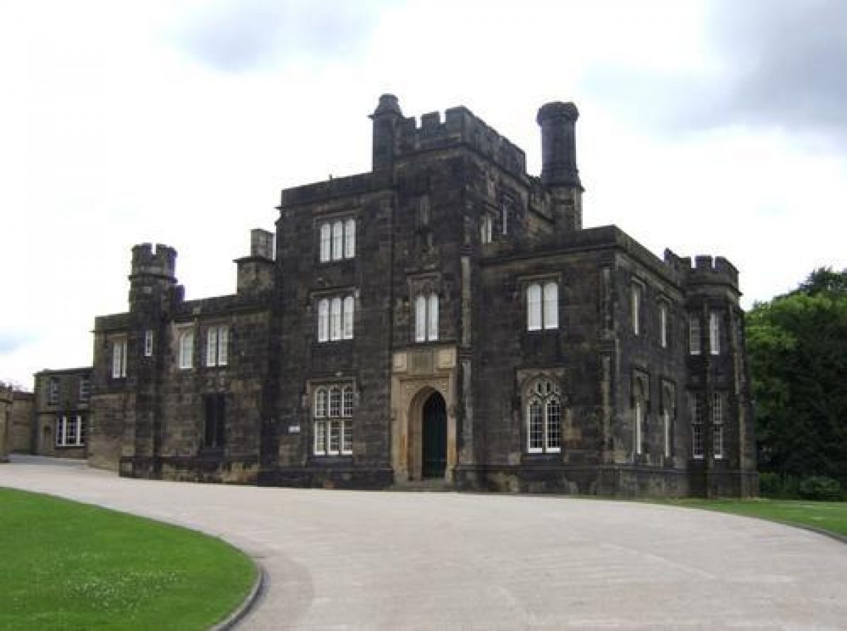
Priory Hall (listed grade II) stands towards the centre of the site on an artificially levelled terrace, from which the ground falls away to the south, east, and north. The house, in Tudor-gothic style, is constructed in ashlar and comprises generally two storeys under a crenellated parapet. The building is lit by stone mullion and transom windows, while the picturesque effect is heightened by corner turrets and decorative chimney stacks.
Priory Hall was constructed for the Earl of Dudley in 1825, with the intention that it should serve as the Earl's residence in the town. It was subsequently used as the agent¿s residence and office, and today (2002) is used as a Registry Office.
GARDENS AND PLEASURE GROUNDS
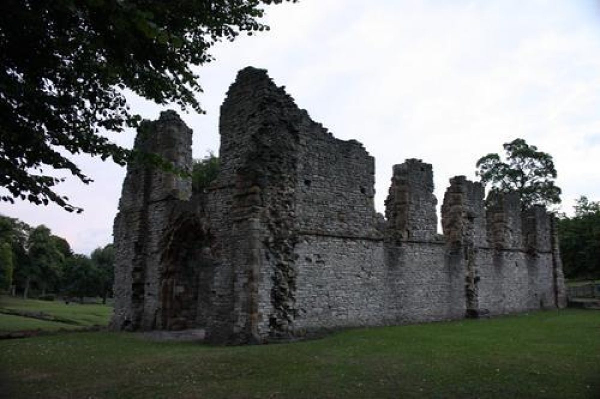
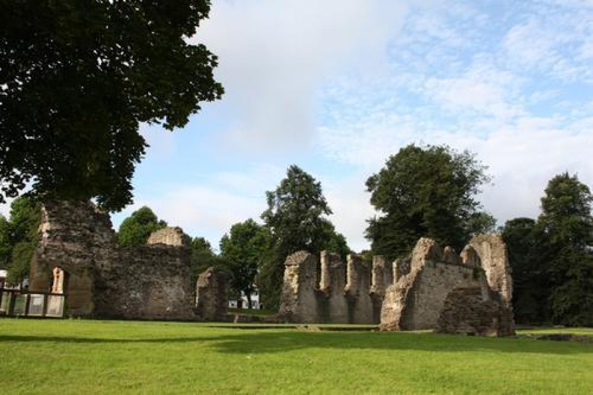
To the south and south-east of Priory Hall, lawns fall away gently and merge with undulating grass planted with specimen trees and shrubs, some of which survive from the C19 pleasure grounds associated with the house (Treasure, c 1830). The remains of St James' Priory (scheduled ancient monument; listed grade I) are situated at the south-east corner of this area. The lawns are screened from public roads to the west and south by evergreen shrubbery.
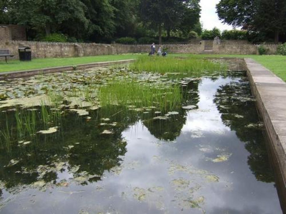
The eastern boundary is formed by Paganel Drive, which separates the park from an area of open space planted with specimen trees known as The Green. A broad rectangular panel of lawn extends parallel to the road on the eastern boundary of the park; several geometrical rose beds survive, while traces of further similar beds can be discerned. At the northern end of this lawn is a sunken garden comprising a rectangular lily pool surrounded by lawns and herbaceous borders, all enclosed within low rubble-stone walls. Stone steps placed at the centre of the north and south walls descend into this area, while to the north, on the axis of the sunken garden, is a raised terrace similarly enclosed on three sides by stone walls, and planted with a pair of specimen monkey puzzles. The sunken garden and terrace appear to form part of E P Mawson's 1929 scheme for the park, and correspond approximately to the site of a pond marked on Treasure's Plan (c 1830). To the north-west of the sunken garden is a shelter (roofless, 2002) comprising a stone terrace enclosed on three sides by stone walls, with circular rubble-stone columns supporting a timber pergola-style superstructure which takes the place of the original roof. The shelter, which was donated by Mrs Norah Hanson JP, was constructed in 1954 (Programme, 1954), and the surrounding area was laid out as a 'rock-studded slope' (Superintendent's Report, 1955); the rocks were removed in the late C20.
Lawns retained by a C19 buttressed stone wall return below the east facade of Priory Hall. The retaining wall supports a mid or late C20 wrought-iron safety fence. A flight of stone steps aligned on the east facade of Priory Hall descends from the lawn to the Italian Garden, a rectangular area enclosed to the north, east, and south by low rubble-stone walls. The garden is laid out with a raised grass terrace to the west supported by further rubble-stone walls, from which a further flight of stone steps descends to a lower terrace which is laid out with a series of geometrical flower beds set in panels of lawn divided by flagged walks. These panels are partly edged by low stone walls. The Italian Garden forms part of E P Mawson's scheme for Priory Park.
From both the east lawn below Priory Hall, and the lower level of the Italian Garden, walks lead north-east to reach the area of park to the north of the Hall. To the north-east of the building a raised mound is planted with mature specimen trees and shrubs. This feature survives from the early C19 pleasure grounds associated with Priory Hall (Treasure, c 1830).
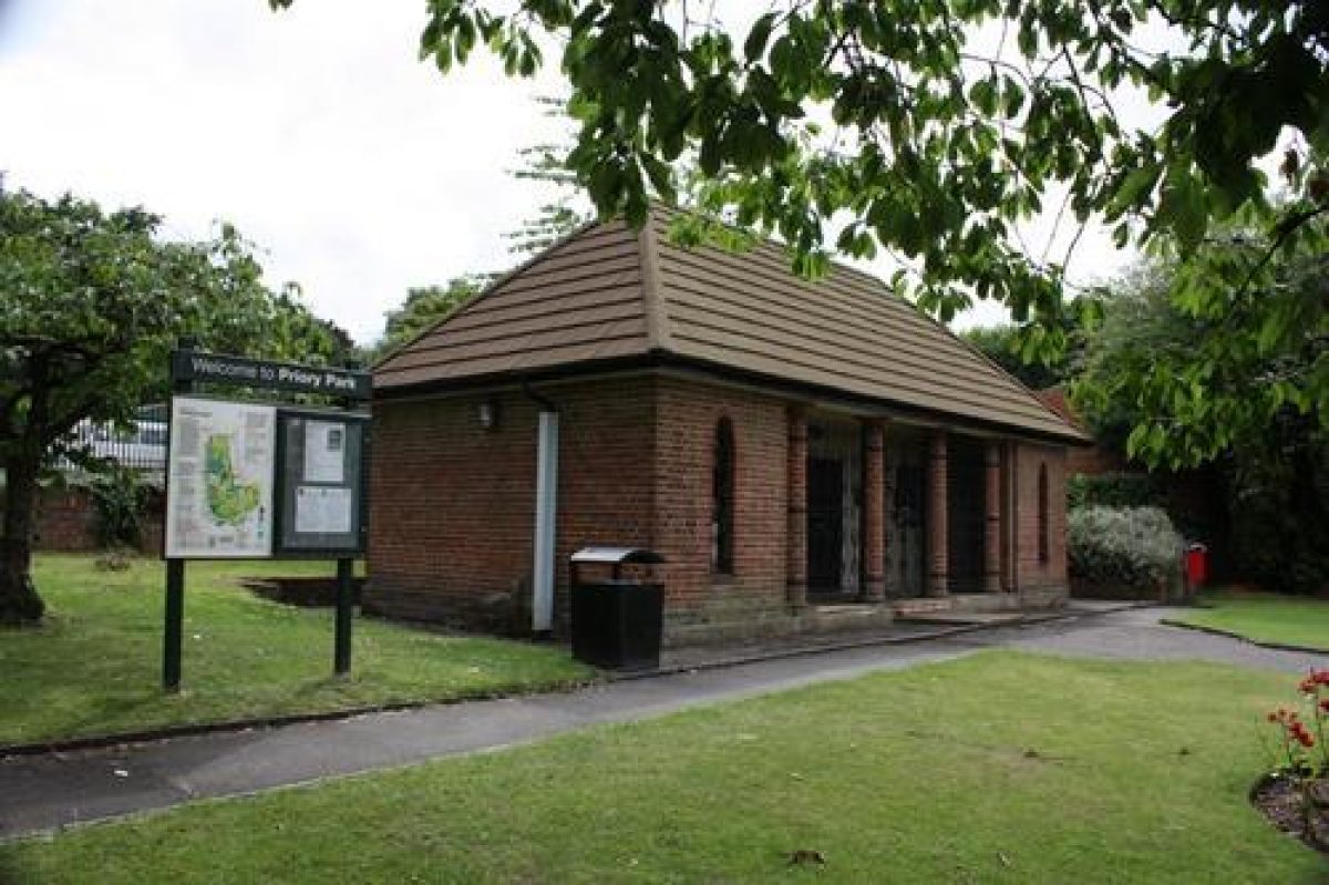
The ground to the north of Priory Hall is laid out for recreation. An axial walk flanked by panels of lawn and geometrical rose beds leads north from a single-storey pavilion through a series of terraces laid out with tennis courts and bowling greens, to reach the northern boundary of the park. The pavilion is constructed in brick, with an open front to the north supported by four circular columns. The structure is now (2002) roofless. The axial walk is broken by shallow flights of steps which correspond to the divisions between each terrace. The two northernmost sets of steps are of different design, with three flights being divided by square stone bastions which formerly contained low topiary yews forming solid cubes. Low hedges separate the northernmost bowling greens (that to the north-east now forming a miniature football pitch) from the axial walk. The southern pitches and green have been relaid in the late C20, some as hard-surfaced tennis courts and one as a children's play area. The tennis courts were originally opened in 1933 by Dorothy Round, a local sportswoman, twice Wimbledon singles champion (1934 and 1937). Hedges which may have separated these areas from the axial walk do not survive.
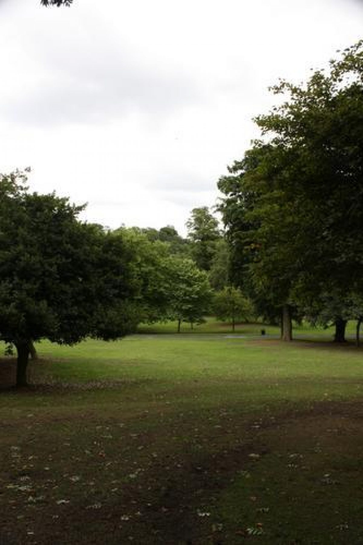
To the north and north-east of the terraced sports pitches are areas of gently sloping lawn planted with specimen trees. A row of horse chestnuts extends long the western boundary of the northern section of the park, while mature shrubbery extends along the eastern boundary as far as the south-east corner of the Italian Garden.
The northern section of the park and the surviving planting formed part of the scheme for the park devised in 1929 by E P Mawson. Despite the alterations to the sports pitches, tennis courts, and bowling greens, this area of the park survives substantially as laid out in 1929.
OTHER LAND
A service yard is situated to the north-west of Priory Hall. This area is today (2002) in mixed used, part being used as a car park while the remainder continues to be used as a municipal service yard. This whole area is enclosed by brick and stone walls to the west, north, and south and by Priory Hall to the east; it corresponds to the early C19 kitchen garden associated with Priory Hall.
REFERENCES
A Guide to Dudley Castle - also a short account of the Priory (1840), p 57
Victoria History of the County of Worcester II, (1906), pp 158-62; III, (1913), pp 101-02
N Pevsner, The Buildings of England: Staffordshire (1974), p 120
English Heritage Register Review: West Midlands (1996)
J Hemingway, An Illustrated Chronicle of the Cluniac Priory of St James, Dudley (2000)
Maps
J Treasure, Plan of the Town of Dudley & its Environs, around 1830 (copy on EH file)
E P Mawson, alternate schemes for the laying out of Priory Park (in Mawson 1929)
OS 6" to 1 mile: 1st edition published 1886
OS 25" to 1 mile: 1st edition surveyed 1884, published 1887; 2nd edition published 1904; 3rd edition published 1919; 1938 edition
Archival items
E P Mawson, The Priory Estate, Dudley - Report on Proposals for its Development prepared under the direction of the Council, 1929 (Dudley Record Office)
Aerial photographs, around 1930 (Dudley Record Office)
Photographs of Priory Park, around 1930 (Dudley Record Office)
Park Superintendents' Reports, 1952-5 (Dudley Record Office)
Programme of the Dedication and Opening of the new Shelter, 1954 (Dudley Record Office)
Description written: October 2002
Amended: May 2004
Edited: June 2004
- Visitor Access, Directions & Contacts
Access contact details
Open daily. For details see: http://www.dudley.gov.uk/see-and-do/parks-open-spaces/the-parks-in-the-borough/priory-park/
Owners
Dudley Metropolitan Borough Council
Council House, Priory Road, Dudley,, DY1 1HF
- History
The following is from the Register of Parks and Gardens of Special Historic Interest. For the most up-to-date Register entry, please visit the The National Heritage List for England (NHLE):
www.historicengland.org.uk/listing/the-list
HISTORIC DEVELOPMENT
A Cluniac priory dedicated to St James was founded at Dudley in about 1150 by Gervase Paganell to the west of the ridge on which Dudley Castle stands. The priory buildings were extended and enhanced during the 14th and 15th centuries, and during the later medieval period its church became the customary burial place for the Lords Dudley.
The priory was dissolved in 1539, when it and its estates were granted to John Dudley, Duke of Northumberland. At the attainder of Northumberland in 1553, the property reverted to the Crown, and was subsequently granted to Edward Sutton, who had been created Lord Dudley, in 1554 (Victoria County History 1906).
During the Civil War the remains of the priory were utilised by parliamentary forces besieging the castle, but the remainder of the 17th and the 18th century saw the ruins pillaged for stone and partially occupied by various manufacturers (Hemingway 2000). Edmund Grose visited in 1776 and noted the remains of fishponds to the north and west of the priory ruins (VCH, 1906). By the late 18th and early 19th century the priory had become an object of antiquarian interest (VCH, 1906).
In 1825 the Earl of Dudley constructed a new residence, Priory Hall (listed Grade II), on land to the north-west of the ruins. Initially intended as a family residence in the town, or as a dower house, the house was later used by the Earl's agent (Pevsner 1974). The priory ruins were incorporated into the grounds of the new house as a picturesque feature.
In order to run a drive through the ruins a large swathe was cut across the site. The industrial additions were removed, rubbish cleared, and the walls planted with ivy. The remains of the medieval fishponds were drained, and a drive leading from the town was constructed, approaching the new house through park-like grounds. Further areas of paddock extended to the east and north of the house (Treasure, around 1830).
Priory Hall and its surrounding land remained the property of the earls of Dudley until 1926, when it was acquired by Dudley Borough Council. It was intended that the majority of the land acquired should be laid out as a housing estate to re-house families living in slum conditions in the centre of the town.
To this end, a development plan was commissioned from Edward Prentice Mawson. In his report (1929), Mawson outlined the rationale behind his proposals: the preservation of the historic interest of the site, while at the same time providing space for recreation. In the broader scheme, the area around the priory was to be reserved for the best class of housing, built at a density not to exceed six houses per acre (Mawson 1929).
Mawson provided a design for the development of the park, showing the existing ornamented ground being retained to the south of the Hall and around the priory ruins, formal gardens to the east of the Hall, and an area of tennis courts, bowling greens and other facilities arranged to the north of the building. The implemented scheme differs significantly from that published in Mawson's Report, but on stylistic grounds the surviving scheme is attributed to him. Today (2002), Priory Park remains municipal property.
- Associated People
- Features & Designations
Designations
The National Heritage List for England: Register of Parks and Gardens
- Reference: GD5167
- Grade: II
Features
- Ruin
- Description: The ruins of the 12th-century Cluniac Priory.
- Hall (featured building)
- Description: In 1825 the Earl of Dudley constructed a new residence, Priory Hall. The priory ruins were incorporated into the grounds of the new house as a picturesque feature.
- Earliest Date:
- Latest Date:
- Ornamental Pond
- Description: Lily pond
- Key Information
Type
Park
Purpose
Recreational/sport
Principal Building
Parks, Gardens And Urban Spaces
Survival
Extant
Hectares
9
Open to the public
Yes
- References
References
- {English Heritage Register of Parks and Gardens of Special Historic Interest}, (Swindon: English Heritage, 2008) [on CD-ROM] Historic England Register of Parks and Gardens of Special Historic Interest
- Pevsner, N., {The Buildings of England: Staffordshire} (Harmondsworth: Penguin Books, 1974), p. 120 The Buildings of England: Staffordshire
- Willis-Bund, J. W. and Page, W. {Victoria County History: Worcester, Volume 2} (London: Constable, 1906), pp. 158-62 Victoria County History: Worcester, Volume 2
- Willis-Bund, J. W. {Victoria County History: Worcester, Volume 3} (London: Constable, 1913) pp. 101-2 Victoria County History: Worcester, Volume 3