Introduction
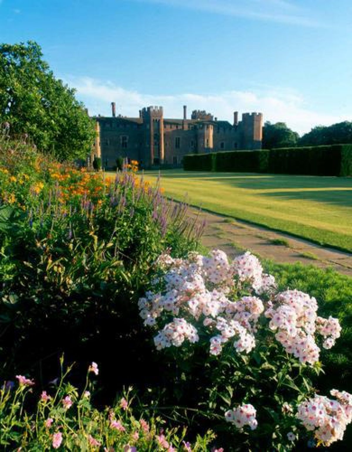
Herstmonceux is renowned for its magnificent moated castle, set in beautiful parkland and Elizabethan gardens. The gardens include a walled garden within which a formal garden was developed in the 20th century. The site includes a rose garden, herb garden and rhododendron garden.
The following is from the Register of Parks and Gardens of Special Historic Interest. For the most up-to-date Register entry, please visit the The National Heritage List for England (NHLE):
www.historicengland.org.uk/listing/the-list
A 15th century castle, surrounded by a medieval park with significant surviving landscape and archaeological features, additional 18th century landscape and built features, and with new and restored elements from the 20th century.
DESCRIPTION
LOCATION, AREA, BOUNDARIES, LANDFORM, SETTING
Herstmonceux Castle and park and Herstmonceux Place which together comprise the 148ha of the registered site lie just to the south of the A271 Hailsham to Battle road. The site is screened on its west side by a woodland belt along Church Road which runs south from the A271, past the west front of Herstmonceux Place to All Saints' church, which sits just outside the south-west corner of the park. To the west of Church Road and south-west of the park's southern boundary, hedged pasture merges into the flat, open landscape water systems of the Pevensey Levels. The east side of the site is bounded by Wartling Road and partly screened by Wartling Wood on its far side. Wartling village lies about 1km away across bordering farmland to the south-east. The northern boundary merges into farmland with small woods.
While the present east and west road boundaries of the park appear to be of early C15 origin and have remained unchanged since, the medieval park extended further to the south and also to the north and north-west, reaching the villages of Windmill Hill and of Gardener Street on the present A271. The estate had been reduced in size to about 160ha by the time a survey was made in 1570 (BM). The Castle is sited at the south end of a stream valley emerging from the very edge of the Weald onto the Pevensey Levels. The parkland rises to the north and east to sheltering wooded crests. To the north-west a high ridge separates the Castle from the site of Herstmonceux Place.
ENTRANCES AND APPROACHES
The present main entrance to the Castle and the park is from Wartling Road in the south-east corner, a drive running c 700m westwards before turning north to the Castle's west-facing entrance front. There is a second entrance in the south-west corner on Church Lane beside West Lodge, built by Godfrey in 1933, the drive from here, known by its post-war name of Flamsteed Road, probably serving as the Castle's principal entrance in the C15 and connecting it with All Saints' church. Both entrances and drives are recorded on the 1570 survey, together with a third gate, Cowper's Gate, on the north boundary north-west of Comphurst Wood. In the C15 the west and east gates were linked by a medieval road which survives (1990s) as a well-defined track lying to the south of the present main entrance drive, which follows a C20 alignment.
PRINCIPAL BUILDING
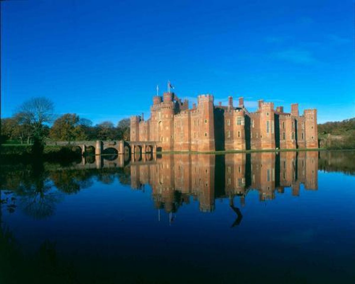
Herstmonceux Castle (listed grade I) stands in the centre of the shallow valley, its principal front facing south. It is square in plan, constructed in the newly fashionable red brick, and is surrounded by two water-filled arms of a moat. It was built from 1441 and replaced the former manor house. Service buildings probably lay to the west on the site of the present C20, cottage-style lodges, one of which serves as a visitor centre and tea room. The present main entrance is on the west. The Castle was largely dismantled in 1777, leaving only its gatehouse and exterior walls intact, and was restored, although to a new interior lay-out, between 1911 and 1932, work from 1929 being carried out by the architect Walter Hines. The central, enclosed courtyard is laid to lawn and an axial flagged path lined by Irish yews, this design being part of Col Lowther's work between 1911 and 1929.
Herstmonceux Place stands on the north-west boundary of the park and commands extensive views over it to the south and east. It has an entrance front of c 1720. Samuel Wyatt enlarged and added two new elevations to the house for the Hare-Naylor family when they moved here in 1775.
East of the Castle, on higher ground, stands the six-domed, former Equatorial Group Telescope building, erected in 1958 by the Royal Greenwich Observatory. It forms a prominent landmark for a considerable distance to the south and west.
GARDENS AND PLEASURE GROUNDS
The area of formal gardens immediately around the Castle include the moat to the south and east and the extended walled garden to the north.
The present moat arms around the south and east sides of the Castle are part of what was presumably a complete square in the C15. An extension northwards from the eastern arm, into the stream valley to form a broad mere, may also be a C15 feature. The mere, which appears to have been restored by Latham, is now managed as a reed bed with the feeder stream running through two channels of open water southwards into the moat. The moat is recorded as already drained by the survey of 1570 and laid out with gardens by the late C18 (CL 1918). The moat was cleared and re-flooded in 1933 by Sir Paul Latham, the present southern arm having been extended to approximately double its original c 20m width by Col Lowther.
The rectangular walled garden (listed grade II) stretches some 200m from the north face of the Castle, over rising ground. A strong formal axis is maintained northwards through the three main compartments. The first, closest to the Castle, contains a central flagged path, laid in 1995 to replace the previous grass surface, which is flanked each side by five free-standing sections of clipped yew hedge. There are rectangular lawns to either side with a flagged perimeter path and herbaceous borders along the east and west walls. A central set of steps leads up to the second, 50m long compartment, at the mid-point of which the path encompasses a circular rose bed, replacing a former pool. There are lawns to east and west. The north wall enclosing this garden is pierced by a central loggia which gives access to the third compartment which is divided by yew hedges into three smaller enclosures. The central one, beyond the loggia, contains a former lily pool or swimming pool which is now laid out to a box parterre. To the west is the tennis court and to the east, a rose garden. The walled garden appears to have been laid out soon after the Castle was built, but was extended before the C17. In the C18 it was in use as a kitchen garden and orchard and was redesigned by Col Lowther with a central axis flanked by roses and with herbaceous borders along the east and west walls. The present (1990s) formal treatment and the addition of the northernmost compartment and loggia were the work of Walter Hines Godfrey in 1933-5.
North-east of the Castle, the extended moat arm is fed by the stream which runs southwards down the valley feeding a tiered chain of pools and dams en route. The stream is culverted through the valley or 'Temple Field', which is now managed as a meadow. The ponds, which have been (1990s) partially cleared from the silted condition they were in in the early C20, were most likely formed by clay digging for the Castle's bricks and may also have numbered among the four stew ponds referred to in the survey of 1570.
The Temple Field is enclosed by woodland and the folly in the style of a little C18 house at its north-east end was built by Sir Paul Latham to serve as an eyecatcher from his rooms in the Castle. South of the Castle are open, level lawns which replace the arena constructed by Col Lowther. Further south, the present pasture landscape is part of a medieval system of water meadows and reed-bed irrigation for which the earthworks survive. There are extensive views over the Levels.
From the south-west corner of the moat, fragmented, linear groups of sweet chestnut trees follow a course northwards for a distance of 820m to the dam below the pond in Comphurst Wood. The trees line the route of the medieval, northern approach to the Castle but are most likely to have been planted by Sir Thomas Lennard in the C17 (Rodwell 1989). Trees are being restored to sections of the route in 1997.
The present gardens of Herstmonceux Place are laid to lawn with surrounding belts of ornamental shrubbery and trees to the north and south. The terrace on the south-east front was added by the James family in the early C20 and commands extensive views over the park to north, east and south.
PARK
The present parkland extends over rising ground to the north-west, north and north-east of the Castle. The open areas are entirely under arable cultivation and virtually none of the scatter of clumps on the north-western slopes shown on the 1st edition OS map surveyed 1873(5 survive in the 1990s. The northern slopes have no parkland trees at all, and only a few individuals are shown on the OS 1st edition. The early C15 manor house was surrounded by a deer park, the survey of 1570 describing the park as bounded by a park pale, laid one third to lawns with 'great timber trees' and stocked with fallow deer. John Norden's map of 1595 shows the oval paled enclosure of the park with a central lake and south-flowing stream. There are few records of the park in the C18 and C19 and by the time of the Tithe survey in 1839, considerable areas of land had already been disparked and laid out to fields.
The park contains a number of woodlands, the largest areas lying to the north-west and north and north-east of Temple Field. Plantation Wood (to the north-east) contains mature C19 rhododendron shrubberies, winding walks and a cascade and is probably of C18 origin although partly replanted and extended west and south in the C20 by the RGO for commercial forestry purposes. The mixed woodland to the north and north-west is also of mid C20 origin, the north-western block on the ridge between Herstmonceux Castle and Place replacing the probably C18 Egg Plantation.
REFERENCES
Country Life, 43 (2 March 1918), pp 214-221; (9 March 1918), pp 242-248; (16 March 1918), pp 270-273; 65 (18 May 1929), pp 702-709; 78 (30 November 1935), pp 566-572; (7 December 1935), pp 606-612; (14 December 1935), pp 630-635
I Nairn and N Pevsner, The Buildings of England: Sussex (1965), pp 534-537
W Rodwell, Herstmonceux Castle, an Archaeological Assessment of the Park (1989)
Garden History 17, no 2 (1989), pp 177-178
Maps
Survey, 1570 (British Museum Add Mss 5679, fo.266)
John Norden, Map of Sussex, 1595
W Gardner and T Gream, A Topographical Map of the County of Sussex..., 1" to 1 mile, surveyed 1795
Tithe map for Herstmonceux parish, 1839 (East Sussex Record Office)
OS Old Series, 1" to 1 mile, 1813
OS 6" to 1 mile: 1st edition surveyed 1875
2nd edition published 1899
3rd edition published 1910
OS 25" to 1 mile: 1st edition surveyed 1875
2nd edition published 1909
Description written: July 1998
Edited: March 2000
- Visitor Access, Directions & Contacts
- History
The following is from the Register of Parks and Gardens of Special Historic Interest. For the most up-to-date Register entry, please visit the The National Heritage List for England (NHLE):
www.historicengland.org.uk/listing/the-list
HISTORIC DEVELOPMENT
The origin of the park at Herstmonceux is unrecorded but it seems likely that it was in existence by the 12th century. The estate, including the park, passed to the Fiennes family in 1330 and in 1441 Sir Roger Fiennes applied for a licence to build the present castle and to enlarge the park. In 1449 the estate passed to Sir Roger's son who later became Lord Dacre.
The Dacre family sold the estate to George Naylor in 1708 and in 1775 the Hare-Naylor family abandoned the Castle and moved into Herstmonceux Place, in the north-west corner of the park. The Castle was virtually dismantled and became a picturesque ruin in the park. The estate was sold to Thomas Reed Kemp in 1807 and purchased from him in 1819 for John Gillon. He sold it in 1846 to H B Curteis of nearby Windmill Hill Place from whom it passed by succession to Herbert Curteis.
The Castle and surrounding park were sold off in 1911, with Herstmonceux Place and Windmill Hill Place becoming separate entities again. Herstmonceux Place was purchased by the James family and retained a significant area of the park. The Castle was partly restored by the new owner, Colonel Claude Lowther. He died in 1929 and in 1932 the Castle estate, plus Herstmonceux Place, was purchased by Sir Paul Latham. He completed the restoration of the Castle and, with his architect, Walter Hindes Godfrey (1881-1961), restored and developed the gardens.
Latham sold the Castle and its park to the Royal Greenwich Observatory in 1946, which erected a series of buildings to house the telescopes. Sir Paul Latham died in 1952 and in 1958 the remainder of the park was sold for agricultural use. Herstmonceux Place was sold and divided into apartments in 1960. In 1989 the Castle and its park were sold to a development company. The International Study Centre of Queen's University (Canada) subsequently purchased the estate and are the present owners. The Equatorial Telescope Group complex is run as a Science Centre.
Period
18th Century (1701 to 1800)
- Associated People
- Features & Designations
Designations
The National Heritage List for England: Register of Parks and Gardens
- Reference: GD1139
- Grade: II*
Features
- Lake
- Folly
- Earliest Date:
- Latest Date:
- Castle (featured building)
- Earliest Date:
- Latest Date:
- Moat
- Rose Garden
- Planting
- Description: Herb garden
- Planting
- Description: Rhododendron Gardens.
- Parkland
- Walled Garden
- Formal garden
- Herb garden
- Key Information
Type
Park
Purpose
Ornamental
Principal Building
Domestic / Residential
Period
18th Century (1701 to 1800)
Survival
Extant
Hectares
148
Open to the public
Yes
Civil Parish
Herstmonceux
- References
References
- {English Heritage Register of Parks and Gardens of Special Historic Interest} (Swindon: English Heritage 2008) [on CD-ROM] Historic England Register of Parks and Gardens of Special Historic Interest
- Nairn, I and Pevsner, N {The Buildings of England: Sussex} (Harmondsworth: Penguin, 1965) pp 534-537 The Buildings of England: Sussex
- ACTA {Herstmonceux Parkland Plan 2 vols} (2012) Herstmonceux Parkland Plan 2 vols
- Related Documents
-
CLS 1/182/1
undated
-
CLS 1/213/1
Hard copy
-
CLS 1/182/1