
Introduction
The site has the remains of a mid-18th-century landscape park within woodland and an agricultural estate, which at its most extensive occupied about 8000 acres. The Park has now been largely returned to agriculture. The gardens extend to about 90 hectares (220 acres) and were originally laid out in the mid-18th-century by Lancelot Brown.
The site is now used as a venue for church groups, retreats, holidays and conferences.
Terrain
The western part lies on both slopes of the shallow valley of the Ashbourne. The land rises irregularly and quite steeply on either side of the valley. The eastern half occupies a high, rounded ridge which rises above the valley to the north-east.
The following is from the Register of Parks and Gardens of Special Historic Interest. For the most up-to-date Register entry, please visit the The National Heritage List for England (NHLE):
www.historicengland.org.uk/listing/the-list
Details
An C18 landscape park and pleasure grounds improved by Lancelot Brown, the structure of which survives, and with significant C19 formal gardens and planting.
DESCRIPTION
LOCATION, AREA, BOUNDARIES, LANDFORM, SETTING
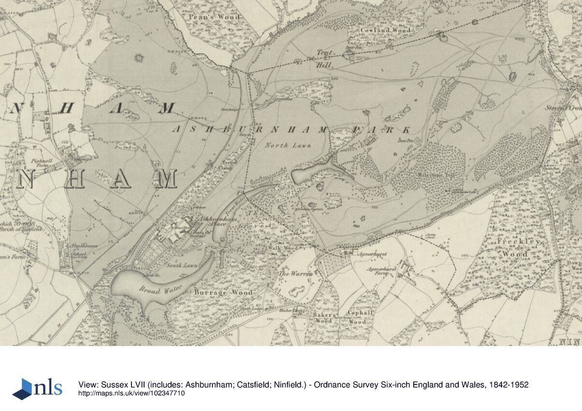
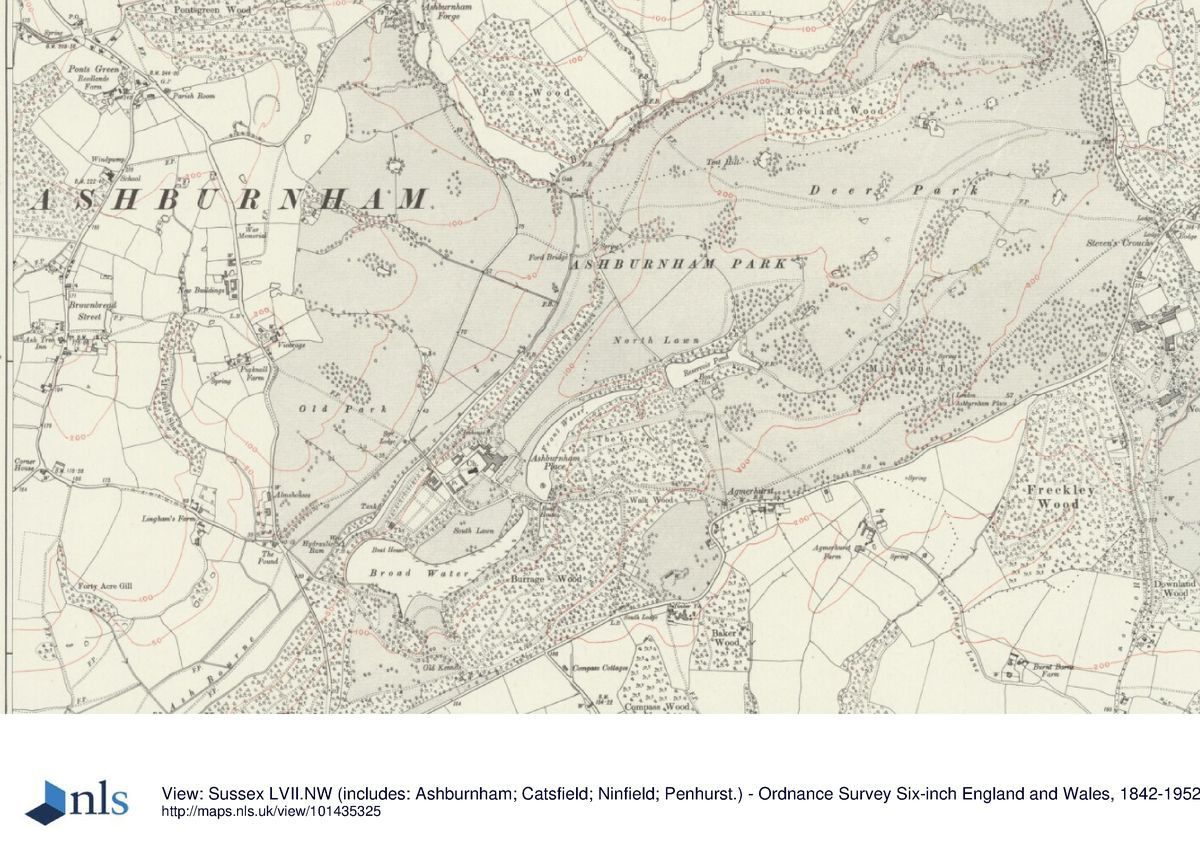
Ashburnham Place lies on the north-west side of the A271 Lewes to Battle road, c 5km west of Battle and 8km north-west of the coast at Bexhill. The registered site covers c 200ha and is bounded along the whole of its south side, which is largely enclosed from view by internal woodland, by the A271, with a landscape of farmland and small hedged fields beyond. A minor lane (Penhurst Lane) skirts the east boundary which is screened from views eastwards by woodland beyond the lane. The north, north-east and west boundaries follow, respectively, the upper course of the Ashbourne stream, a tributary and the road north to Dallington village. These boundaries give onto wooded farmland slopes beyond. With minor exceptions, including a subsequently straightened section of the A271, the site boundaries remain as recorded on Gardner and Gream's map of Sussex of 1795.
The western half of the site lies on both slopes of the shallow valley of the Ashbourne which runs from north-east to south-west. The land rises irregularly and quite steeply on either side of the valley. The eastern half occupies a high, rounded ridge which rises above the valley to the north-east. Views from the house and pleasure grounds are contained within the valley.
ENTRANCES AND APPROACHES
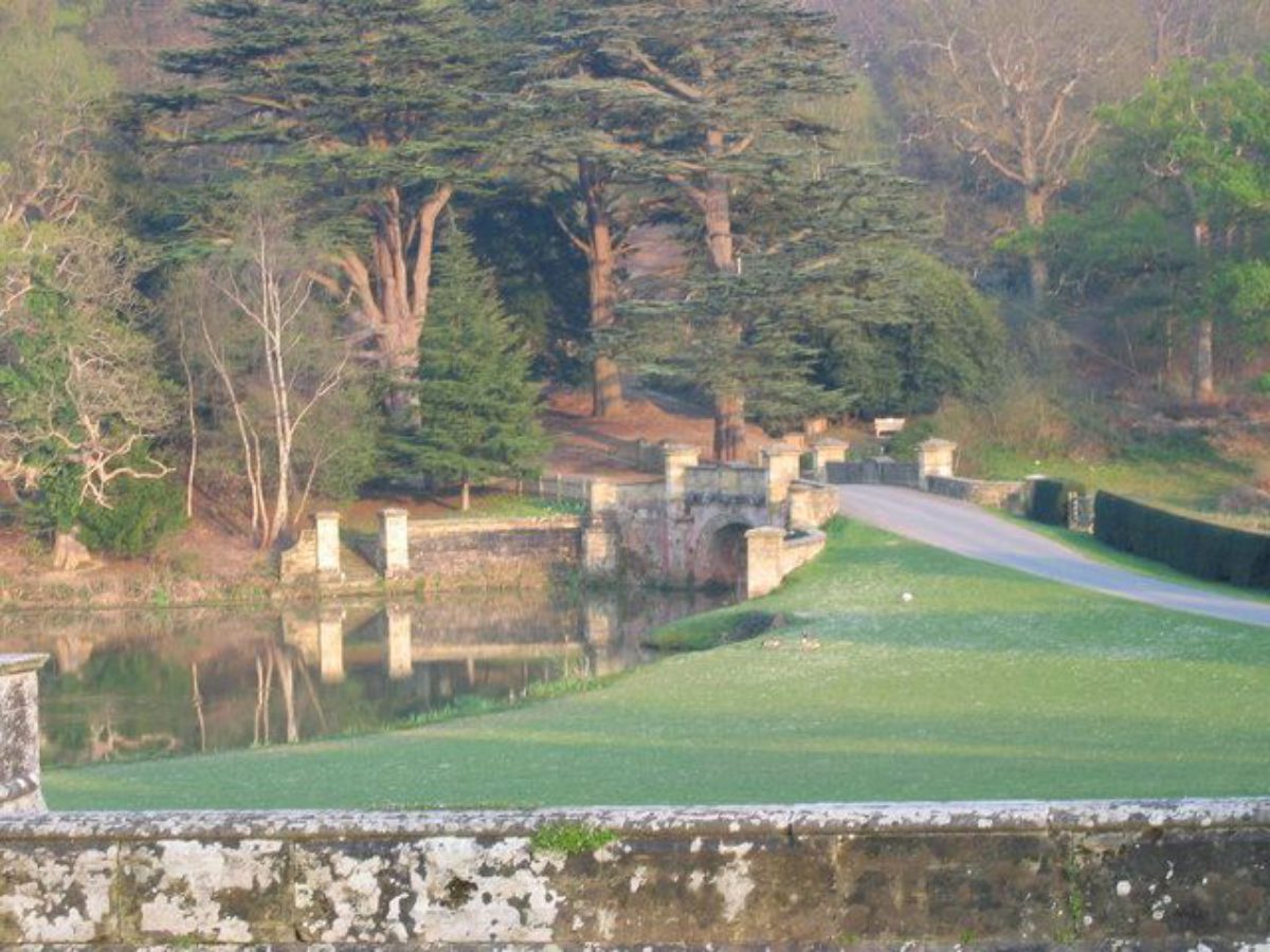
The present, principal entrance is on the A271 Lewes to Battle road at South Lodge (lodge, gate piers and walls listed grade II). The drive runs north from the Lodge through Walk Wood then turns westwards to cross between Front Water and Broad Water on George Dance's bridge (listed grade II), built in 1813 to replace Lancelot Brown's original timber bridge. Beyond the bridge the drive turns north to approach the house on its principal, south-east front. Although South Lodge was not built until 1835, the main entrance to the park appears to have been from this position up to the late C18. Edward Elphick's map of 1717 shows a drive leading to the house from this point on the main road which was still in existence in 1795 (Gardner and Gream map). Visitors to Ashburnham, however, are recorded as late as 1953, the year of Lady Catherine's death, as entering the estate c 1km further east at the Battle Lodge (outside the registered site at the junction of the Battle road and the B2096 to Netherfield and listed grade II; Sussex County Magazine). This approach passes west along a pine avenue in Beechdown Wood (also outside the registered site) to enter the park at the junction of the A271 and Penhurst Lane beside West Lodge (C19 lodge with gates and pavilions by Robert Adam c 1780, listed grade II). It continues westwards from West Lodge as a track through the deer park, running parallel to the A271 and passing Grove Lodge (listed grade II), to meet the present main drive in Walk Wood at a point some 200m east of Dance's bridge. This eastern approach, shown established on Gardner and Gream's map of 1795, may have become the principal approach to the house after Brown's improvements of the late C18.
Brown's survey plan dated 1767 also shows the line of what may have been a mid C18 approach from Walk Wood to the house; this swept much further west before crossing the present Broad Water. A note on Brown's plan proposes to 'alter the water and take away the garter' (his name for the existing bridge over a narrow leg of the water). There is field evidence of a former road crossing the South Lawn on the north side of Broad Water.
PRINCIPAL BUILDING
Ashburnham Place (listed grade II), with St Peter's church (listed grade I) immediately to its west sits on the north-west slope of the valley, overlooking the chain of lakes and the park woodland beyond. Although the house is truncated from its C18 form, with the church (rebuilt to its present form in 1665) and the stable block (built between 1720 and 1730 and listed grade II*) a visually cohesive group of buildings is created. The house was built in 1665 and enlarged to its final form by 1763 with the addition of the domestic wing facing the church, the long range of state rooms which made up the south front. Brown's greenhouse, with seven bays (now the Orangery, listed grade II*), stands attached on the west side. The brick house was refaced twice, once in 1813 by George Dance and again in 1850 with the present red and grey brick. The house had reduced to a state of decay by the mid C20. It is now about three-quarters of its former size, the remainder having been demolished in 1959. The present (1990s) owners have made considerable additions from the 1960s onwards, on and around the house's previous ground plan. Brown's Orangery survives intact.
GARDENS AND PLEASURE GROUNDS
These lie to the south-west of the house and on the valley slopes around the chain of lakes. In the mid C18, the formal gardens were restricted to a small enclosed parlour garden north-east of the house with an orchard and stackyard to the south-west and a mill pond.
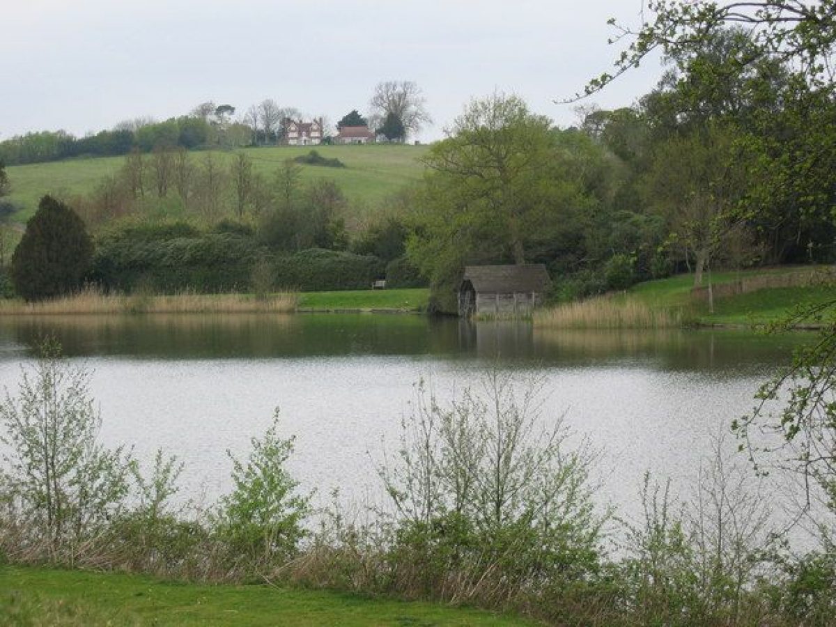
On the south front of the house are formal raised terraces on two levels, partly enclosed by balustrades and approached by two central flights of steps. These (listed grade II) were designed by George Dance (1741-1825) in 1813 and in the early C20 were laid out with box parterres and carpet bedding. They are now (1997) laid to lawns with rose and perennial beds. The terraces extended around the east front of the house but this section was largely built over in the 1960s. A small portion remains in the north-east corner. On the west side of the house, the Orangery opens southwards into its square garden which is laid to lawn with a central fountain and an enclosing south wall (listed grade II). In front of the Orangery and at each corner of the lawn, dwarf box hedges are close-clipped in the shape of fans, a design which has survived since the mid C19. The West Garden is approached from the Orangery garden down a flight of steps. It is enclosed by iron railings which are of C19 origin and is screened from the drive on its south side by clipped hedging. Much of the gardenesque-style layout of trees and shrubbery survives from the 1930s. Westwards beyond the West Garden, the Dial Walk passes through Brown's surviving shelter belt of yew and holm oak, planted against the south wall of the kitchen garden. A small car park has now been incorporated here. To the south, the open South Lawns shown on Brown's plan slope down to the edge of the Broad Water, with the boathouse (shown on OS 1st edition map surveyed 1873-5) 15m to the west of the lawns.
West of the kitchen garden, the path leads on to the circuit walk around the lakes which form Brown's principal work at Ashburnham. The Mill Pond and Old Pond shown on the estate map of 1717 were dammed, enlarged and reshaped to create the present Broad Water, while Front Water appears to have been expanded from a formal rectangle of water south-east of the house (estate map, 1717; mid C18 painting, CL 1953). The whole chain, including Reservoir Pond at the north-east end, extends c 1km along the valley floor.
On the south side of Broad Water, the lakeside walk passes through woods in existence in the C17 (estate map, 1638) and cut through by Brown to create planted glades. The walk passes a Greek temple, sited almost opposite the boathouse (probably also Brown's work) and, c 50m further east, Ladyspring meadow, now managed for wild flowers. At the south-east end of the meadow the Lady spring is housed in a small stone grotto of mid C18 origin. The majority of the pleasure grounds as far as Tent Hill (beyond the house to the north-east) can be viewed from here. The walk passes along the northern edge of Burrage Wood which was cut with formal, axial rides in the early C18 (estate map, 1717), subsequently altered by Brown and re-planted in the mid 1990s after storm damage in 1987. East of the Wood, the walk passes the silted remains of the toe of Front Water to meet the main drive. On the north-west shore of Broad Water is a wooded Winter Garden, shown established on the 1st edition OS map. A central fountain inscribed with the date 1936 overlooks the C18 brick tunnel carrying the water from Front Lake to Broad Water.
East of the house, a walk leads north-east from the axis of the front terrace along the north shore of Front Water and past a group of cedars, probably planted in the early C19. The walk continues north to North Lawn (now under arable use) and around the east end of Reservoir Pond. A small cascade connects the two lakes. Enclosing North Lawn to its north-west is a Victorian tree belt planted between 1840 and 1875 (Tithe map; OS 1st edition) known as Target Clump which also contains a pinetum and the site of an icehouse. The belt closes Brown's proposed vista from the pleasure grounds north into the Old Park.
South of Front Water a series of walks and rides pass through glades in mixed woodland containing exotics and rhododendron. This is shown laid out as 'The Grove' on Brown's plan and was developed from its early C18 layout of formal compartments and from what appears to have been a wilderness.
PARK
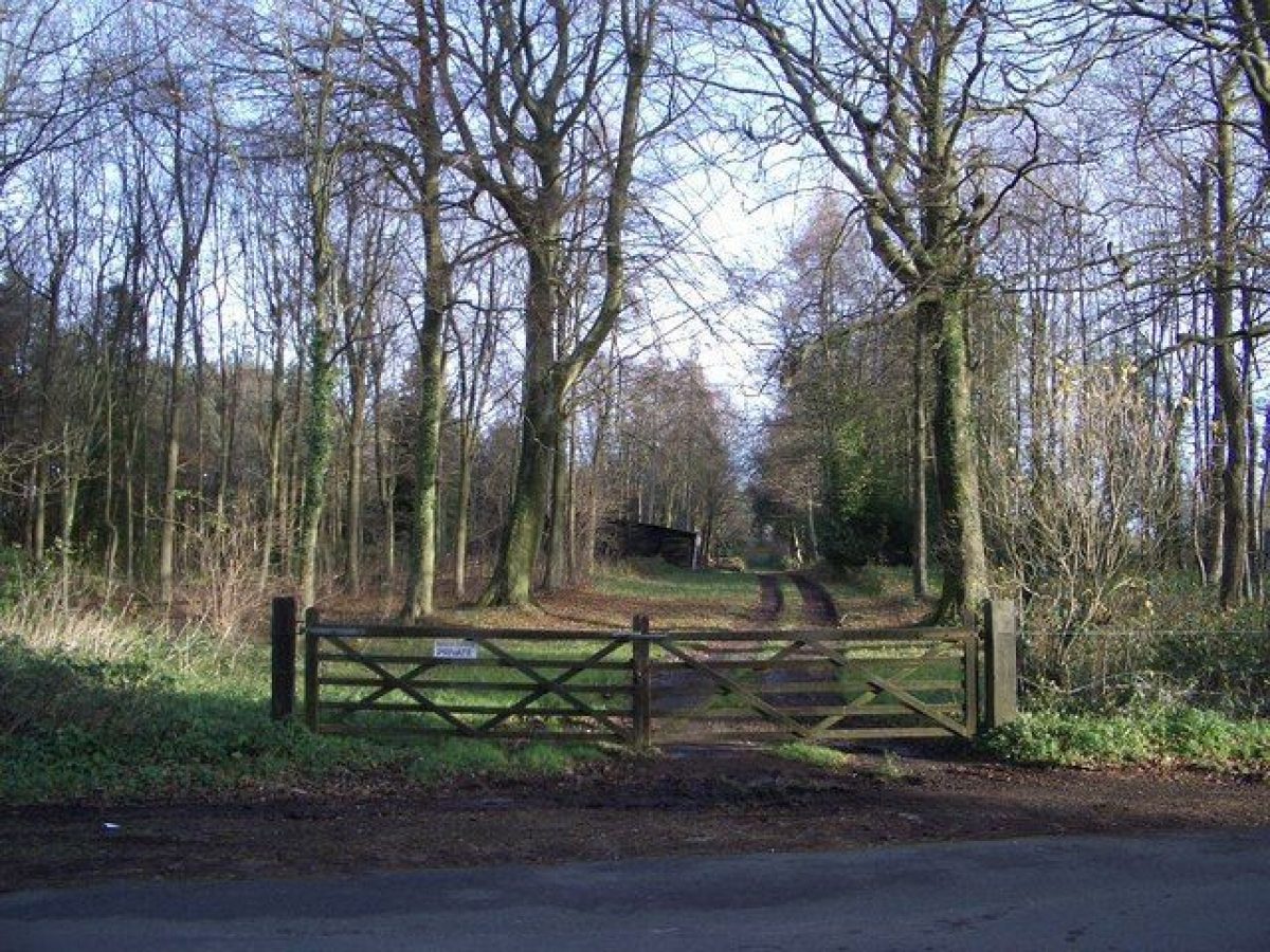
The two parts of the park at Ashburnham are separated by the Ashbourne valley. Imparkment probably dates back to Saxon times. The Deer Park lies to the north-east and rises to over 60m above the level of the house. It contains areas of semi-natural ancient woodland, although the scattered great oaks do not appear to have been pollarded. The early C17 Deer Park Cottage (listed grade II), which was the Ranger's Lodge of Ashburnham Park, lies 800m north-west of the park entrance at West Lodge.
The parkland to the north of the house rises steeply up the valley side before dropping to the former site of Ashburnham Forge. Its western part is recorded as The Old Park on the estate map of 1717 and the whole area is shown with additional planting on Brown's plan. A number of clumps and belts survive, some of which appear to relate to his proposals. Only one short section of his proposed perimeter avenue ride appears to survive on the northern boundary.
The Old Park and Deer Park landscapes are connected across the valley both visually and by the early C18 drive now followed by the public footpath. The open areas of both parts of the park are now under intensive arable use with the loss of a limited number of individual trees, probably during the last forty years. Other areas are overgrown with bracken and bramble and fenced off. The most extensive views of the estate and the wider landscape of the Weald and South Downs are gained from the Park.
KITCHEN GARDEN
The kitchen garden lies to the west of the stables. It measures some 200m in length and is surrounded by 3.6m high brick walls. The garden was part of Brown's scheme and is shown in the early 1870s with quartering paths and rows of trees. It is currently laid out to grazing and vegetable cultivation and contains some outbuildings. A Prayer garden with a pergola and lawns surrounded by flower beds has recently been laid out in the south-east corner.
REFERENCES
Country Life, 39 (22 January 1916), pp 112-18; (29 January 1916), pp 144-51; 113 (16 April 1953), pp 1158-60; (23 April 1953), pp 1248-50; (30 April 1953), pp 1334-8
Sussex County Magazine 7, (1933), pp 6-13; 27, (1953), pp 566-74
Victoria History of the County of Sussex IX, (1937), pp 126-7
Architectural Review, 96 (December 1944), pp 159-62
I Nairn and N Pevsner, The Buildings of England: Sussex (1965), pp 400, 409-10, 468
D Stroud, George Dance (1971), pp 216-19
D Stroud, Capability Brown (1975), pp 400-1, pls 40B, 41A,
B A G Kinghorn (or Kingham), Thesis on Ashburnham Place (1979) [copy at Ashburnham Place]
Garden History 17, no 2 (1989), pp 176-7
Dr O Johnson, The Trees at Ashburnham Place (1994) [copy on EH file]
Ashburnham Place, Grounds and Gardens, guidebook, (Ashburnham Christian Trust, nd)
Maps [all held in East Sussex Record Office]
Anthony Everenden, An exact and perfect Survey and view of the Demesnes Landes of the mannor of Ashbornham..., 1638
Edward Elphick, A map and Description of a parcel of land scituate Lying and being in the Parish of Ashburnham in the County of Sussex..., 1717
R Budgen, An Actual Survey of the County of Sussex ..., 1724
W Gardner and T Gream, A topographical map of the County of Sussex..., 1" to 1 mile, surveyed 1795
Tithe map of Ashburnham parish, c 1840
OS 6" to 1 mile:
1st edition surveyed 1873-5
2nd edition published 1899
3rd edition published 1910
4th edition published 1931
OS 25" to 1 mile:
1st edition surveyed 1873-5
2nd edition published 1909
3rd edition published 1930
Archival items
Plans and drawings by Lancelot Brown for the alterations at Ashburnham Place, dated 1767 (ASH 4458, ASH 4357(63), (East Sussex Record Office)
Description written: January 1997
Amended: July 1998, June 1999
Register Inspector: VCH
Edited: February 2000
- Visitor Access, Directions & Contacts
Telephone
01424892244Website
https://www.ashburnham.org.uk/Access contact details
Reception/Bookings Office is open
Tuesday – Sunday 9am – 4pm
Monday – not open
Directions
Note the postcode may take you to our ‘backtrack’ which is closed for public access.
Please use the main entrance to Ashburnham Place found via the A271 Kitchenham Road.
- History
The grounds in their present form were designed and constructed in the mid-18th-century by Lancelot Brown. He laid out the three large lakes which encircle the house and built the Orangery, which is home to a number of interesting and unusual plants, as well as the oldest camellias in the country.
The gardens also contain a temple and the 'Ladyspring' grotto, a classical style ruin built around a freshwater spring. The walled kitchen garden is still used to provide flowers and vegetables.
The following is from the Register of Parks and Gardens of Special Historic Interest. For the most up-to-date Register entry, please visit the The National Heritage List for England (NHLE):
www.historicengland.org.uk/listing/the-list
HISTORIC DEVELOPMENT
The Ashburnham family became established on the estate from at least the mid C12. In 1665, John Ashburnham built a new house on the site of the present mansion, replacing an older house. He died in 1671. His nephew was created Baron Ashburnham, the baronetcy becoming an earldom in 1731. The second Earl reconstructed and enlarged the house between 1759 and 1763 and commissioned Lancelot Brown (1716-83) in 1767 to lay out a new park and gardens around the house of which the lakes and much of the planting structure survive.
The third Earl succeeded in 1812, his additions between 1812 and 1817 including the terraces to the south and east of the house and the bridge across Front Water. The sixth Earl died in 1924 and the line ended with the death of his niece, Lady Catherine Ashburnham in 1953. The Rev J Bickersteth, a grandson of the sixth Earl, inherited the estate and in 1960 gave Ashburnham Place and 89ha, including the main gardens and pleasure grounds, to the Ashburnham Christian Trust who have since developed it as a Christian Conference Centre. The remaining parkland is farmed on behalf of the Trustees of the Ashburnham Estate.
- Associated People
- Features & Designations
Designations
The National Heritage List for England: Register of Parks and Gardens
- Reference: GD1042
- Grade: II*
Features
- Lake
- Description: 3 lakes laid out by Lancelot Brown
- Earliest Date:
- Latest Date:
- Orangery
- Description: Designed by Lancelot Brown
- Earliest Date:
- Latest Date:
- Temple
- Grotto
- House (featured building)
- Now Conference Centre
- Earliest Date:
- Latest Date:
- Parkland
- Woodland
- Gardens
- Key Information
Type
Garden
Purpose
Ornamental
Principal Building
Domestic / Residential
Survival
Extant
Hectares
90
Open to the public
Yes
Civil Parish
Battle
- References
References
- Stroud, D {Capability Brown} (1975) pp 400-401, Capability Brown (Country Life article)
- {English Heritage Register of Parks and Gardens of Special Historic Interest} (Swindon: English Heritage 2008) [on CD-ROM] Historic England Register of Parks and Gardens of Special Historic Interest
- Pevsner, N and Nairn, I {The Buildings of England: Sussex} (Harmondsworth: Penguin, 1965) pp 400, 409-410, 468 The Buildings of England: Sussex
- ACTA {Ashburnham Place Historic Landscape Study and Management Recommendations} (2004) Ashburnham Place Historic Landscape Study and Management Recommendations