Introduction
Grove Park is a municipal park on the site of a late-17th century house and grounds. The registered area covers some 3 hectares. The park's boundaries are formed by stone walls, brick walls, fences and hedges. The site slopes steeply towards the south-west, giving views across the park and town to the bay.
The following is from the Register of Parks and Gardens of Special Historic Interest. For the most up-to-date Register entry, please visit The National Heritage List for England (NHLE):
A late C19 public park developed by the Town Surveyor, A E Collins, from existing early and mid C19 pleasure grounds.
Location, Area, Boundaries, Landform and Setting
Grove Park is situated c 250m north-east of the seafront at Weston-super-Mare. The c 3ha site is bounded to the north by Upper Church Road, to the east by Grove Lane, and to the south by Grove Road and a public footpath, Lovers' Walk. To the south-west the site adjoins Lower Church Road, while to the west and north-west it adjoins the gardens of the early C19 former rectory, Glebe House, and the parish church of St John the Baptist. The boundaries separating the park from public roads and walks are formed by stone walls, those to the south and south-east supporting late C19 or early C20 wrought-iron railings. The western boundary adjacent to Glebe House is closed by a brick wall c 2.5m high, while other boundaries are formed by fences and hedges. The site slopes steeply from north-east to south-west, allowing views south-west from the high ground across the park and town to Weston Bay and Brean Down. To the north and north-east the site is adjoined by substantial late C19 and early C20 villas which overlook the park; Grove Park Road is aligned on the northern entrance to the site. Oriel Terrace (c 1847) overlooks the park from its south-west boundary.
Entrances and Approaches
The principal approach to Grove Park is from Grove Road to the south. To the south-west a vehicular entrance flanked by a pair of stone piers leads to a late C20 car park which occupies the site of a large concert pavilion which was built in 1923 and was subsequently destroyed by bombing in 1941. The car park is separated from the park to the north by late C20 metal railings. To the south-east a pair of wrought-iron gates supported by a pair of stone piers lead to a wide walk which extends north for c 65m to a further pair of wrought-iron gates which give access to the park itself. The walk is bounded to the west by a late C20 toilet block which forms the eastern boundary of the car park. The two entrances on Grove Road are linked by early C20 wrought-iron railings; the entrance gates and railings replaced the elaborate late C19 cast-iron gates and integral lamp standards shown in early C20 photographs in 1923. Some 200m south-east of Grove House a further entrance leads into the park from Grove Lane. The entrance comprises a pair of late C20 wrought-iron gates which are supported by a pair of C19 stone piers; to the north-east of the entrance stands a two-storey mid C19 Tudor Gothic-style stone lodge. Beyond the entrance a drive ascends north-north-west to reach Grove House, while a walk extends west through the southern section of the park. The entrance, lodge, and drive survive from the early C19 landscape associated with The Grove which was developed by the Rev Piggott and the Smyth-Piggott family from c 1805.
Further entrances flanked by low, square-section stone piers lead into the park from Upper Church Road to the north and north-west, and from Grove Lane to the north-east. None of these entrances retains their original late C19 cast-iron gates. The north entrance is aligned on Grove Park Road, a late C19 residential street. There are informal entrances leading into the park from Lovers' Walk to the south-west.
Principal Building
Grove House comprises a mid C19 two-storey gabled stone structure with a late C20 extension to the west. The C19 building is constructed in Tudor Gothic style and formed the coach house to the early and mid C19 cottage residence developed by the Rev Piggott and the Smyth-Piggott family. This house stood immediately to the west of the coach house and was damaged by incendiary bombs in 1941; it was subsequently demolished. Today (2001), the coach house and its late C20 extension are used as the Mayor's Parlour for Weston-super-Mare.
Gardens and Pleasure Grounds
Grove Park falls into three areas, each with a contrasting character: formal gardens, lawns, and tennis courts to the south and south-west of Grove House, informal woodland walks to the north and north-east of Grove House, and extensive rock gardens to the north-west.
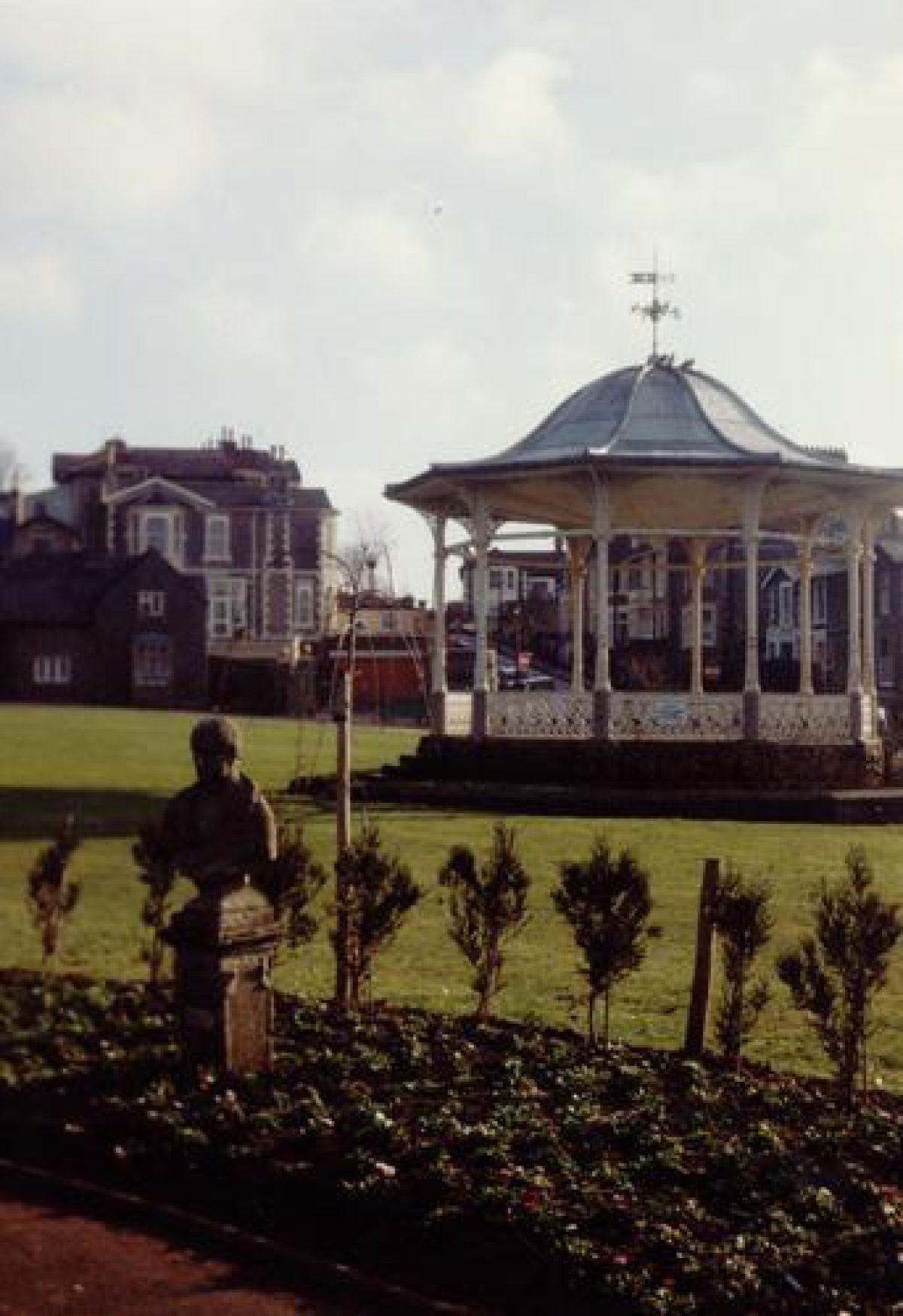
To the west of the lodge and entrance from Grove Lane is an area of lawn, at the centre of which stands an octagonal bandstand (listed grade II). Constructed in 1890-1 by Hill Bros, Sun Foundry, Alloa, the bandstand comprises an octagonal rubble-stone drum which supports cast-iron columns and brackets surmounted by an ogee lead roof and weathervane. The lawn and bandstand are overlooked from the north-east by a late C19 ornamental brick and timber shelter which is backed by trees and shrubs planted on the steep south-facing slope south-east of Grove House. The bandstand and shelter were among the features constructed in 1890-1 under the supervision of the Town Surveyor, A E Collins, as part of the conversion of the private pleasure grounds into a public park.
Some 100m west of the bandstand is a group of hard tennis courts. These are screened from the lawns to the east by a belt of ornamental trees and shrubs, while to the south, adjacent to Lovers' Walk, is a further area of ornamental planting and lawns. To the north of the tennis courts a pergola planted with wisteria and laburnum runs parallel to the boundary with the gardens of Glebe House. Entered through an ornamental wrought-iron gate designed by James Blunt in 1995 (inscription), the pergola walk leads c 70m west from the body of the park to reach a mid C20 Garden of Fragrance (inscription) situated immediately south of the parish church. Approximately rectangular on plan, the sensory garden comprises a central lawn bordered by walks, with raised beds retained by brick walls around the perimeter. At the centre of the lawn is a raised pool and cascade, while to the west is a square-section seat ornamented with mosaics of the seasons (1996). The sensory garden was constructed in 1958, and is overlooked from the west by Oriel Terrace, a mid C19 development to the west of Lower Church Street.
North-east of the tennis courts and north-west of the bandstand lawn an area of formal gardens incorporating an early C20 war memorial extends c 200m from north to south. The garden is terminated to the south by a circular pond, formerly containing a fountain (T Moore pers comm., 2001), to the south of which is a pair of semicircular flower beds planted with mature specimen yuccas and late C20 herbaceous subjects. The border to the south-west contains a weathered stone bust on a low plinth, possibly depicting Francis Bacon. This survives from a group of sixteen stone busts purchased by J H Smyth-Piggott from Walpole's collection at Strawberry Hill which were moved to the area around the pond between 1910 and 1913 (Lambert 1998). The present circular pond was constructed c 1922, replacing a C19 elliptical pond surrounded by rustic rockwork. To the north of the pond a rectangular lawn ornamented with geometrical beds for seasonal planting and specimen yuccas extends c 60m to a lateral walk. To the east of the lawn is an area of lawns, flower beds, and shrubbery below the retaining walls of the terraced gardens south-east of Grove House. A recess to the south-east of this lawn corresponds to the site of now-demolished public conveniences. Beyond the lateral walk is a further lawn divided into quarters by cruciform walks, the intersection of which is marked by a memorial in the form of a pedestal surmounted by a bronze figure of Victory. Stone steps placed on the central north/south axis of the formal gardens ascend from this lawn to a Second World War memorial backed by a yew hedge. The First World War memorial and the associated formal gardens were constructed in 1922, replacing an area of informal lawns and shrubbery which were derived from the early and mid C19 park associated with The Grove.
To the east of the statue of Victory a further flight of stone steps ascends to a terrace which extends along the west and south sides of Grove House, partly occupying the site of the early C19 house which was demolished following bomb damage in 1941. To the south-east of Grove House, at a lower level and approached by a flight of stone steps at its north-west corner, is a rectangular terrace enclosed to the south-west and south-east by castellated stone balustrades. The terrace is laid out as a rose garden with geometrical beds set in lawns surrounding a central rectangular pool and fountain. The castellated retaining walls and stone steps appear to correspond to those shown in Whereat's engraving published in 1847, and may relate to garden walls built c 1805 (ibid).
To the east and north-east of Grove House the ground rises steeply, with flights of steps ascending from points c 20m and c 140m south-east of the House to join a walk which extends c 150m north through a lime avenue to reach the north entrance to the park which is aligned on the axis of Grove Park Road to the north. The avenue passes through an area of south-west-facing sloping lawns, which are enclosed to the west and south-west by informal groups of trees and shrubs. To the north-east and east a curvilinear walk follows the boundary of the park, providing access to an ornamental late C19 or early C20 open-fronted Arts and Crafts-style shelter at the north-east corner of the site. Views south-west to the sea and Brean Down from the shelter and upper lawn are now (2001) partly obscured by tree growth on the lower slopes. Some 20m south-south-east of the shelter is a late C20 children's play area enclosed by fences. Immediately east of this a level area corresponds to the site of an early or mid C19 observatory erected by J H Smyth-Piggott; this structure survived until the late C20 as a picturesque ruin (ibid), but today no trace remains above ground. The upper lawns formed part of the early and mid C19 landscape associated with The Grove which was developed by J H Smyth-Piggott, and which was subsequently adapted to form a public park in 1890-1.
To the north-west of the upper lawn the ground drops steeply into a dell formed by late C18 or early C19 quarrying. The lawn is separated from this dell by late C19 wrought-iron fencing, while the perimeter walk extends west of the north entrance to allow access to the dell. A flight of informal stone steps c 70m south-west of the north-entrance also gives access to this area. The dell is enclosed to the north and north-west by slopes planted with trees and ornamental shrubs which screen Upper Church Road. The banks incorporate exposed natural rock and stratified arrangements of boulders planted with shrubs. Below the perimeter walk further areas of planted rockwork are divided by crazy-paved serpentine paths and stone steps, while c 100m south-west of the north entrance an informal pond is fed by an artificial cascade (dry, 2001). This pond, which is set into the boundary bank, feeds a chain of a further three pools surrounded by rockwork and linked by a water course. The lowest pool feeds a further cascade which descends to a small basin surrounded by rocks and shrubs adjacent to a formal walk c 10m north-west of the war memorial. The perimeter walk continues as a terrace to the north-west and west of the rock garden, allowing views across the pools and rockwork to the lower park to the south-east. To the south-east of the rock garden, and immediately north of the grounds of Glebe House, is a small service yard with C19 brick and tile-roofed sheds, while to the north of the war memorial garden is a mid C20 toilet block (disused, 2001). The site of the rock garden lay outside the C19 ornamental landscape associated with The Grove (ibid) and was developed under the supervision of the Town Surveyor, A E Collins, in 1890-1.
Additional Research
Grove Park is a very varied site. The northern area is on higher ground and is wooded with many paths and steps. To the north-west there is an attractive rock garden with several pools. The house at the centre of the park is all that remains of Grove House. To the south of it can be seen the walls (built in 1805) surrounding the rose garden.
A war memorial dominates a rectangular garden to the west of the house (which was bombed during the war). A second memorial to the civilian casualties of the wars stands at the northern end of this area. The war memorial was unveiled on 11th May, 1922.
There is a circular pond and a bandstand to the south. From near the pond a pergola walkway leads to a garden of fragrance containing a shelter, an aviary and a small rectangular pond.
Trees along Lovers' Walk used to form a grove with trees on the site of the present car park. One of these trees has within its branches some of the iron railings thrown there by the blast of the bombs in 1942. In the winter of 1980/81 many young trees were planted around the car park to improve the look of the southern end of the park, and to partially restore the grove from which the house took its name.
Grove Park is recognised as perhaps the finest of Weston-Super-Mare's parks. It is well-maintained by the local authority and well-used by the public.
Maps
- Enclosure map for Weston parish, 1810 (Somerset Record Office)
- Tithe map for Weston parish, c 1840 (Somerset Record Office)
- OS 6" to 1 mile:
- 1st edition published 1885
- 2nd edition published 1904
Illustrations
- Mr Pigot's Cottage, early C19 drawing (North Somerset Museum Service)
- The Grove from the south, engraving (in Ruttter 1829, Delineations)
- J Whereat, The Grove, Weston-super-Mare, 1847 (North Somerset Museum Service)
- Late C19 and early C20 photographs (North Somerset Museum Service)
Description written: June 2001
Register Inspector: JML
Edited: November 2021
- Visitor Access, Directions & Contacts
Telephone
07973 676767Access contact details
This is a municipal park for general public use.
Owners
North Somerset Council
PO BOX 146, Town Hall, Weston-super-Mare, BS23 1LH
- History
Grove House became the property of the Pigott family in 1696. The park was their private garden.
John Hugh Pigott made alterations to both the house and garden. In January 1805 the walls around the field and orchard were started, and in 1835 and in the 1840s extensions were built onto the house. ‘John Hugh Smyth-Pigott (1793-1853) not only filled the Grove and the family home with fine paintings, sculptures, books and curiosities but also planted out Weston Woods. The trees of the Grove stretched farther north than the present park boundary to merge with the new woods on the Pigott lands on the hill. Although intended as a game reserve, the woods should also be seen as part of the landscaping movement in the county during the late eighteenth and early nineteenth centuries' (Evans, 1980).
When Strawberry Hill, Horace Walpole's country house near Twickenham was sold, John Hugh Smyth-Pigott bought a collection of statues. Two of these can be seen beside the pond in Grove Park.
John's grandson, Cecil Hugh Smyth-Pigott was the last to make the Grove his permanent home.
The Corporation's works of 1890 included putting in a bandstand (costing £135), urinals, paths and seats, and the amalgamation of Quarry Road. This all cost £1,095. The ponds at the rockery are built over the site of a small quarry and the road around it was re-routed. The park was officially opened on June 20th, 1891.
After Cecil Hugh Smyth-Pigott's death in 1893 the town, having already acquired the park, took over the house and used it for various purposes. First it was a library, then a café and then a private house.
On 4th January, 1941, the house was bombed and all the old part destroyed. The ruin was demolished in 1952 and was replaced in 1958 by a modern bungalow. Since the local government reorganisation in 1974 the house is used by Weston's mayor and Charter Trustees as a Mayor's Parlour.
The gates at Connaught Place are in memory of Mr. W.H. Norton, founder member of Weston-Super-Mare and District Allotments and Gardens Association. Mr. Norton died in November 1969 aged 81.
The following is from the Register of Parks and Gardens of Special Historic Interest. For the most up-to-date Register entry, please visit The National Heritage List for England (NHLE):
19th Century
In the early C19 Weston was a small village standing in sand dunes on the Bristol Channel coast. Two of the cottages in the village served as rural retreats for landowners with seats elsewhere: the Smyth-Piggotts of Brockley Hall, and the Rev Leeves, vicar of Wrington. In 1810 the Smyth-Piggotts' steward, Richard Parlsey, secured the enclosure of Weston, and the same year, in partnership with John Cox of Brockley, opened a hotel in the village. After a tentative start, the resort developed steadily in the 1820s, with a coach connection to Bristol being established in 1814, and the first guidebook for visitors, emphasising the town's rural simplicity, in contrast to the more sophisticated pleasures of Bath or Brighton (Lambert 1998), appearing in 1822.
In the 1820s extensive tree-planting was undertaken by John Hugh Smyth-Piggott on the hill to the north of the town, walks and drives were laid out, and villas were constructed on the lower slopes. Some schemes such as Royal Crescent (c 1847) and Ellenborough Crescent (1855) incorporated areas of communal private pleasure grounds, while commercial pleasure grounds were opened at Flagstaff Hill (later Prince Consort Gardens) and the Enclosure, Madeira Road. A seafront walk was laid out in 1826, but in the mid C19 the only area of public open space was the cemetery, laid out in 1856. Pressure for the provision of further public gardens was resisted by the Board of Commissioners until the 1880s when economic conditions forced the Smyth-Piggott estate and other developers gradually to sell or lease land to the town for the provision of parks (ibid). In this way Grove Park was acquired for the town in 1890.
In 1804 a house known as The Grove was the home of the Rev Wadham Piggott, curate of Weston, whose family had owned the manor of Weston since 1696. In the early C19 the Rev Piggott developed The Grove as a seaside retreat, describing improvements to the grounds in a letter to the Bristol artist, George Cumberland in 1805 (ibid). The Enclosure award of 1810 enabled Piggott to create a small park which is shown with lawns, shrubbery, and a sweeping drive in an engraving of 1847 by Whereat. Immediately around the house Piggott constructed terraced gardens which are shown in a lithograph of 1829 by John Rutter.
In 1815 the Rev Piggott's niece and heiress married John Hugh Smyth (1792-1853) of Aston Court (qv), who assumed the name Smyth-Piggott and took up residence at The Grove. A cultured art collector, J H Smyth-Piggott improved the grounds at The Grove, building an observatory and installing a collection of sixteen stone busts bought from the sale of Horace Walpole's collection at Strawberry Hill, Twickenham (qv). The estate passed to J H Smyth-Piggott's eldest son, John Hugh Wadham Smyth-Piggott in 1862, and to his grandson, Cecil Hugh Smyth-Piggott in the early 1880s. C H Smyth-Piggott faced a decline in income from the development of Weston-super-Mare, and in 1889 decided to consolidate his estate at Brockley Park, offering The Grove and adjacent glebe land for sale for development. This was strongly opposed by a parishioners' meeting and by the Weston Gazette. Despite some public opposition, the Board of Commissioners entered into negotiations with Smyth-Piggott which resulted in the acquisition of The Grove for the town at an annual rent of £300.
In April 1890 a Local Government Board loan of £2000 was sought towards the cost of converting the private pleasure grounds into a public park. This work was undertaken by the Town Surveyor, A E Collins, and was completed by 20 June 1891 when Grove Park was opened to the public as the town's premier public park. New features included a bandstand, rockeries, a refreshment room in the former manor house, a pavilion, and extensive floral displays.
20th Century
In 1922 a war memorial and associated formal gardens were constructed in the park, while the following year a large glass-roofed pavilion was built at the southern end of the park. This structure was destroyed by incendiary bombs in 1941, while The Grove was also damaged and subsequently demolished leaving only the C19 coach house. During the 1930s further formal features were introduced into the park, while in the late C20 glasshouses on the terraced gardens south of Grove House were replaced by a rose garden, and a car park was constructed on the site of the 1923 pavilion.
21st Century
Grove Park remains in municipal ownership and regularly has events taking place.
- Features & Designations
Designations
Conservation Area
- Reference: Melrose/Grove
The National Heritage List for England: Register of Parks and Gardens
- Reference: 5175
- Grade: II
The National Heritage List for England: Listed Building
- Reference: Bandstand
- Grade: II
Features
- Bandstand
- Description: The bandstand dates to the late-19th century. The ironwork is by Hill Brothers, Alloa. There are cast iron columns and balustrade on a rubble base, an Ogee lead roof with overhanging eaves on cast iron brackets, and a weather vane.
- Earliest Date:
- Latest Date:
- Bungalow (featured building)
- Description: The 17th-century building was demolished in 1952 and replaced by a modern bungalow in 1958. Since 1974, the house has functioned as the Mayor's Parlour.
- Earliest Date:
- Latest Date:
- Planting
- Description: This feature is the walled rose garden, which lies to the south of the original Grove House.
- Earliest Date:
- Latest Date:
- Pond
- Description: There is a circular pond.
- Fountain
- Key Information
Type
Park
Purpose
Recreational/sport
Principal Building
Civil
Survival
Extant
Hectares
8.5
Open to the public
Yes
Civil Parish
Weston-super-Mare
- References
References
- Jane Evans {Mr. Pigott's Cottage near the Bristol Channel} (1980) Mr. Pigott's Cottage near the Bristol Channel
- List of buildings of special architectural or historic interest, District of Woodspring (former borough of Weston-Super-Mare)
- {Weston Mercury} The Weston Mercury
- {English Heritage Register of Parks and Gardens of Special Historic Interest} (Swindon: English Heritage 2008) [ onCD-ROM] Historic England Register of Parks and Gardens of Special Historic Interest
- Rutter, J., (1829) Delineations of the North Western Division of the County of Somerset
- Rutter, J., (1829) The Westonian Guide
- Baker, E. E., (1887) A Chronicle of leading events in the history of Weston-super-Mare in the last fifty years
- Baker, E. E., (ed) (1901) John Chilcott's 1822 Guide to Weston-super-Mare
- Poole, S., (1987), (1991) Weston-super-Mare in Old Photographs Weston-super-Mare in Old Photographs: 1950s
- Lambert, D., (1998) Historic Public Parks: Weston-super-Mare
Contributors
E. J. Spiller
Avon Gardens Trust