Introduction
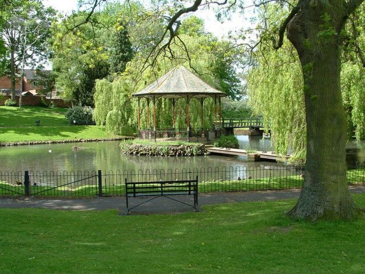
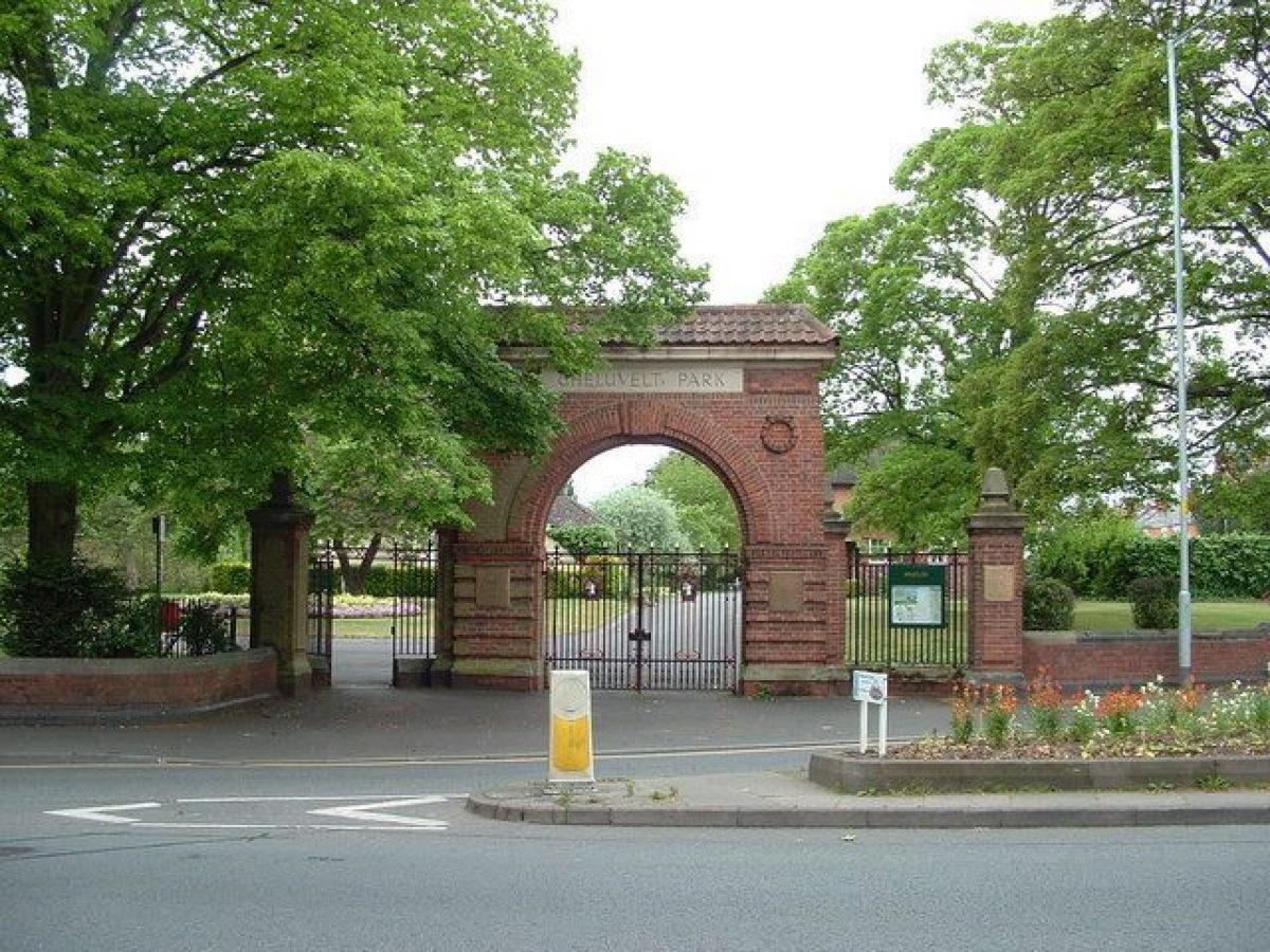
Gheluvelt Park was opened in 1922. Its entrance is marked by a triumphal arch. There is a bandstand in a lake. A row of houses along its northern edge was built in 1919 as sheltered housing for disabled servicemen.
www.historicengland.org.uk/listing/the-list/
Summary of Garden
A war memorial park, including homes for ex-servicemen, designed and laid out by Alfred Hill Parker and including parts of the layout of an earlier garden landscape on the site. Details
LOCATION, SETTING, LANDFORM, BOUNDARIES, AREA
Gheluvelt Park, 9.7 acres, lies to the west of the Barbourne Road, the chief access route to the centre of Worcester from the north which, as it progresses south, becomes first The Tything and then The High Street. The surrounding area, called Barbourne, is now principally filled with late-C19 and early-C20 terraced, suburban housing, although in the C18 and early C19 it was comprised of detached villas with large gardens. The park area is bounded by Lavender Road to its north and Barbourne Lane and Waterworks Road to the south. To the west of the park, on the other side of the Barbourne Brook, is open land which was formerly the site of filtration beds for the water works. The Barbourne Brook runs through the park and continues to join with the River Severn which lies ¼ mile to the west.
ENTRANCES & APPROACHES
The principal approach is from the Barbourne Road to the east. There are two gates, the northern one of which appears to have been a drive gate to Barbourne House (latterly Barbourne College). The present entrance consists of a brick memorial arch, erected c. 1924 with accompanying lateral gates, screens and wing walls, designed by Alfred Hill Parker. The second entrance from Barbourne Road is a pedestrian gate. Another pedestrian gate is on Barbourne Lane, close to the children's playground, and there is a gateway from Lavender Road to the park, which also gives access to the groundsmen's service yard. A bridge over the Barbourne Brook connects Gheluvelt Park to the open grassland to the west which was formerly part of the waterworks.
PRINCIPAL BUILDINGS
In addition to the memorial archway and gates (see above) the park contains twelve houses which were built as homes for wounded sailors and soldiers. They are arranged along the northern boundary of the park in joined groups of one, two or three houses. They face south over the park and back onto Lavender Road and were built between 1919 and 1920 in an Arts and Crafts style with sweeping tiled roofs and dormer windows. The architect was Alfred Hill Parker, who was also responsible for designing the memorial archway (see ENTRANCES & APPROACHES above) and for the overall layout of the park. The bandstand was the gift of the High Sheriff of Worcestershire, Alfred Wiggin, in May 1923. It is sited on an island in the middle of the pond, with both forming a central feature of the landscape. The bandstand is approached by a timber bridge set on masonry cutwaters, which was a gift from a Mr James Ward.
PARK
The park developed out of the large garden of a late-C18 suburban house, and this landscape was itself partly formed by the Barbourne Brook which runs across the land and the large, club-shaped pond which is a remnant of the fulling ground which inhabited the site in the early C18. The park has evolved over the course of almost a century since it was opened as a memorial to those who died in the First World War, but the overall plan with distinct areas for recreation, housing and open lawns with banks of trees and flower beds has remained as it was conceived.
The houses for servicemen are positioned at the north of the site. This is similar to the placing of the former Barbourne House and takes advantage of the sloping southern views across the site towards central Worcester and also helps to raise the buildings out of the flood plain of the Barbourne Brook and the River Severn.
To the south of the housing at a lower level is the pond with its island and bandstand, these built elements forming a central N-S axis. The most notable cross axis is the broad driveway which runs from the entrance arch at the north-east corner in front of the servicemen's houses, connecting them and giving an air of formality to their setting. It is placed on the topmost terrace with flowerbeds to either side.
Below this is the interactive water feature, which has now replaced the former paddling pool. Around these central elements of housing, pool and bandstand are further flowerbeds. To the east of this the park has a lawned area crossed by paths, and planted with mature deciduous trees and younger, specimen trees. The mature trees have made this formerly open area shady in the summer. The eastern boundary has a belt of deciduous trees forming a screen to the Barbourne Road. To the west of centre is a further lawned area with tennis courts in their original position and the site of the former tennis pavilion, given by Richard Cadbury, but which has now been lost. The south side of the tennis courts are shielded by a line of poplar trees. Immediately to the west of the servicemen's houses are the groundsmen's yard and the Sons of Rest shelter. The park keeper's house and former lavatory block are in the north-west corner, bordering Lavender Road.
The Brook is crossed by four bridges: that to the west is a modern wooden plank bridge which forms the approach from the former waterworks site. Two more bridges are placed at either end of the pond. That to the west has wooden balustrades and incorporates a sluice gate, while that to the east of the pond is of brick. The fourth bridge at the far east and close to the Barbourne Road is also of brick. The bed of the stream is lined with concrete, thus allowing children to play in the water which was the original intention. To the south east corner is a play area for children, as was originally intended, now with modern play equipment. To the south side of the central pond are trees and a shrubbery which help to shield the backs of houses on Barbourne Lane.
The war memorial of 2010 by Plincke Landscapes is set in the south-east corner, slightly to the north of the brook and consists of a circular arrangement of Corten steel panels, representing the fallen from various engagements and battles of the First World War.
Selected Sources
Books and journals
Pevsner, N, Brooks, A, The Buildings of England: Worcestershire, (2007), 761
Lambert, D, 'A Living Monument:Memorial Parks of the First & Second World Wars' in Garden History, , Vol. 42, (), 42-3, 45, 47, 55, 56
Other
Worcester City Council, General Purposes Committee, Minutes 1920-1924 [496.5 BA 11241/E15/Box 3/2 Worcestershire County Archives]
Worcester Riverside Parks, Historical Survey, appendix to Heritage Lottery Fund bid for Gheluvelt Park, Worcester City Council and Plincke (2006)
Reasons for Designation
Gheluvelt Park, Worcester, a memorial park of c.1919 to 1924, is designated at Grade II for the following principal reasons:
* Landscape Design Interest: it is a good and representative example of a war memorial park, a relatively rare landscape type, displaying significant attention to layout, created after the First World War by the noted local architect Alfred Hill Parker;
* Group Value: the park has strong group value with a number of associated heritage assets including the contemporary houses for disabled servicemen at Nos. 1-12 Gheluvelt Park (recommended for listing at Grade II), the Memorial Arch, gates and wing walls (recommended for listing at Grade II), and the Bandstand, Gheluvelt Park (recommended for listing at Grade II);
* Intactness: the park has remained largely intact.
- Visitor Access, Directions & Contacts
Telephone
01905 722233Website
https://www.worcester.gov.uk/leisure-parks-allotments/parks-green-spaces/park-sites/gheluvelt-parkAccess contact details
The park is open daily.
Directions
In Worcester city centre.
Owners
Worcester City Council
The Guildhall, High Street, Worcester, WR1 2EY
- History
The following is from the Register of Parks and Gardens of Special Historic Interest. For the most up-to-date Register entry, please visit the The National Heritage List for England (NHLE):
www.historicengland.org.uk/listing/the-list/
The battle of Gheluvelt was an early engagement in the First World War. The British Expeditionary Force had established a line to prevent the German forces reaching the Channel ports. On 31 October 1914 the Germans broke through this line and the 2nd Battalion of the Worcestershire regiment was sent to plug the gap and did so with a bayonet charge in the grounds of the Chateau at Gheluvelt in Flanders. They pushed back the German force of more than a thousand men, but with the loss to the battalion of 34 men and 158 injured. The victory was seen by many as highly significant, and a turning point in the early history of the war. At the opening of the park, on 17 June 1922, Field Marshal John French said that 'on that day the 2nd Worcesters saved the British Empire'.
In the C18, the land on which Gheluvelt Park was to be laid out was owned by the Cookes family who leased it to a Mr Garaway. It was apparently used as a fuller's yard for making sailcloth, with seven or eight ponds fed by the Barbourne Brook. At this time the land nearest to Barbourne Road was described as a ‘whitening yard' and a building which straddled the brook was perhaps used as a mill or in connection with fulling.
Barbourne House, with its park and grounds, was built and laid out during the late C18 and Revd. Thomas Cookes is recorded as living in the house in 1788. The house was located on the site of the current Nos. 7-12 Gheluvelt Park and to its west was a service yard approached along the route of Lavender Road, which was then a private driveway. The house and grounds were sold to JP Lavender, a banker who owned adjacent land, in 1838. At this time there was a kitchen garden to the west of the service yard and a lawn to the south of the house, surrounded by shrubberies. At the southern foot of the sloping lawn was a fish pond, with the Barbourne Brook flowing through it, which is likely to correspond to the present pond and, below a weir, was a further fish pond or stew, described in later sales particulars as ‘anciently a bath'. To the west of the garden was a paddock with trees and to the east was a meadow. Lavender sold the house in 1881 and it became a school, known as Barbourne College, recorded as such on the Ordnance Survey map of 1904. The gardens of the college featured the Barbourne Brook, which flowed across the land and had been diverted to create the large pond which still exists in the park and would appear to be part of the C18 layout. To the east of this was a large lawn on the site of the former 'whitening yard' with a circular pathway, sometimes referred to as ‘the meadow'. In 1909 the site was again on the market and Worcester City Council considered buying the land, but the First World War intervened. The sales particulars reveal that the kitchen garden still existed, and there is mention of a croquet ground, apparently in the middle of the former meadow area, and of tennis courts.
The Worcester City Council General Purposes Committee minute books (see sources) show that it was agreed to buy the land and the college buildings for £2,300 in January 1918, and to accept the mayor's offer to subsidise the purchase. The committee minutes reveal further progress: on 6 September 1918 Alderman Alfred Hill Parker, an architect with an office in Worcester, presented a plan for the layout of the park, and it was also agreed that the land should be known as Gheluvelt Park in commemoration of the significant victory won by the Worcesters. By 1919 a resolution had been passed to start on the layout and to deposit refuse on those areas where the ground needed to be raised and to give manual labouring tasks to the unemployed. An estimate for £3,230 to lay out the park was presented by the borough engineer in February 1920. A broad roadway was planned in front of the homes for ex-servicemen, and land to the west, which included the former pleasure grounds and paddock of Barbourne House, was raised by the tipping of town waste to create a series of four terraces with turf slopes or rockeries on the northern side of the park, gradually sloping towards the brook and the pond on the south side. The terraces were also intended to form an amphitheatre, looking towards the planned bandstand, which was not initially designed to sit on the island in the pond, which had been intended as a refuge for wildfowl. In March 1920 it was decided to include recreation areas, amongst them a children's playground and a tarmac 'beach' to the south side of Barbourne Brook, plus six tennis courts. These alterations, as well as the need to make the bed of the brook safe for children by means of a concrete lining, pushed the estimated cost up to £4,540. The mayor offered a drinking fountain in October 1922 so that children would not drink out of the brook, and in May 1923 the High Sheriff of Worcestershire, Alfred Wiggin, gave the bandstand to be set on the island in the pond, while a third donor, Mr James Ward, offered the bridge to get to it. Twelve houses for ex-soldiers and seamen, also designed by Alfred Hill Parker, were built along the northern side of the park in 1919-20. From November 1919 there had been discussion of the placing of a tank in the park as a feature, including the practicalities of removing its engine and regular cleaning. It seems to have been placed to the east of the Servicemen's houses, in the centre of a large, oval flowerbed, but was removed at some time in the mid-C20. Horticultural advice was given by Earl Beauchamp's head gardener from Madresfield Court, Mr Crump, although he declined to oversee the work.
The layout of the park appeared to be reaching the final stages in October 1923 when the turfing of the tennis courts and gravelling of the paths were discussed at a meeting, together with the employment of a ‘superannuated policeman' to keep order at band concerts. In January 1924 the siting of the arch was agreed upon, set close to the road and with a fence of oak pales marking the rest of the boundary. In April 1924 a motor mower was bought and in September swings and see-saws were approved for the children's playground; these various expenditures seem to have marked the completion of the park in its initial incarnation.
Later work included a greenhouse, bought in 1925, and the tea house to the west of the tennis courts which was gifted by Richard Cadbury in 1925. In 1928 a putting green was laid out and a miniature railway was installed which survived until the 1960s. In May 1939 a new house for the park keeper, including a public lavatory block, was planned by the city surveyor, CI Carey Walker, and built on the north side to the west of the servicemen's homes. The wooden shed for the Sons of Rest (an organisation for retired servicemen) was built in 1953 to the west of the servicemen's houses to commemorate the coronation of Queen Elizabeth II. In 1963-4 it was found that the brook was being polluted by local industry and it was consequently enclosed by hedging and a new paddling pool was built, to safeguard children's health, to the south of the servicemen's houses.
The park suffered damage from flooding in 2007 from the River Severn and the Barbourne Brook. A grant of £810,000 was made by the National Heritage Lottery Fund in 2010. Resulting works in the park have included the replacement of the railings along the Barbourne Road, the renovation of the Bandstand, the replacement of the former paddling pool with a new water feature, the building of two concrete table tennis tables and the restoration of the lavatory building in the south-east corner of the park. A war memorial in the south-eastern corner was commissioned from Plincke Landscapes at a cost of £33,000.
Period
- 20th Century (1901 to 2000)
- Early 20th Century (1901 to 1932)
- Features & Designations
Designations
The National Heritage List for England: Register of Parks and Gardens
- Reference: 1425120
- Grade: II
Features
- Triumphal Arch
- Lake
- Bandstand
- Key Information
Type
Park
Purpose
Recreational/sport
Principal Building
Parks, Gardens And Urban Spaces
Period
20th Century (1901 to 2000)
Survival
Extant
Hectares
3.92
Open to the public
Yes
- References