Introduction
The site originated in the 11th century as the country residence of the Bishops of London. The gardens (originally moated) and grounds are of 16th-century origin, with varied and extensive subsequent development. At its full extent the site covered about 15 hectares. In the late-19th century and then again in 1924, the site was divided into separate areas, of which Fulham Palace gardens and Bishop's Park form a part.
Terrain
Level.The following is from the Register of Parks and Gardens of Special Historic Interest. For the most up-to-date Register entry, please visit The National Heritage List for England (NHLE):
Fulham Palace: II*; 1029
Location, Area, Boundaries, Landform and Setting
Fulham Palace is located in Fulham, c 6km south-west of central London on the north bank of the River Thames. Putney Bridge lies c 100m to the south-south-east. Situated within the line of the former moat, the c 14ha grounds of Fulham Palace form a rough square and are bounded to the north-west by Bishop's Avenue, and to the north-east by Fulham Palace Road and by the rear gardens of houses on the south side of Fulham High Street. The graveyard and associated buildings of All Saints' church, Fulham (listed grade II*) forms the boundary to the south-east, and Bishop's Park (qv) the boundary to the south and south-west. The grounds are largely enclosed within iron railings which reflect the line of the c 2km long medieval moat which, until the early 1920s, enclosed the site. The results of research and of archaeological excavations since c 1970s indicate that the origins of the moat stem at least from the Roman occupation of the site (Whitehouse 1983).
Entrances and Approaches
Fulham Palace is approached along Bishop's Avenue, a 350m avenue lined with mature plane trees which runs west-south-west from Fulham Palace Road. After c 10m the avenue passes, on the south side, the entrance to the Moat Garden and after a further c 50m the entrance to the Warren and a number of school buildings. The school, built in c 1960 as St Mark's Secondary School, now (2000) houses All Saints' Primary School and The Moat School. The Avenue continues along the north-west boundary of the site to the main entrance.
The entrance from Bishop's Avenue is guarded by sturdy C19 gothic gate piers hung with C20 iron gates. The gate piers (listed grade II), made from limestone ashlar with traceried panels, brattished cornice, and pyramidal caps, are attached to the remains of the C15 Moat Bridge (listed grade II). The limestone parapet walls with triangular coping are the only visible remains of the bridge to survive after the moat was filled in c 1921-4. To the north-east of the entrance is the early C19 lodge (listed grade II), built in Tudor-Gothic style. Rendered to imitate stone, the largely single-storey lodge has dormers to the south-east, decorative bargeboards, a circular turret, and colossal twisted chimneys. A second brick-built lodge, to the south-west of the main entrance, was constructed in the late C19 (OS 1894).
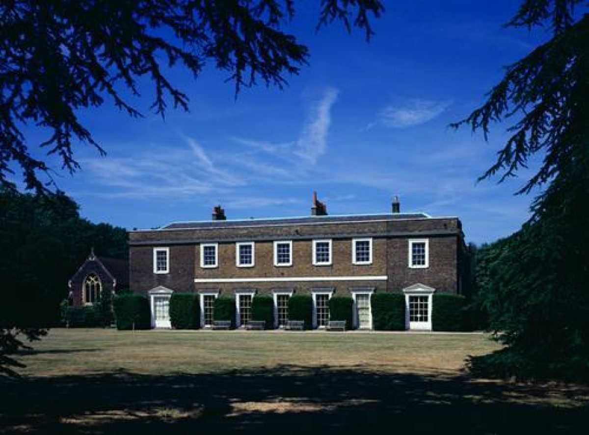
Principal Building
The brick buildings of Fulham Palace (listed grade I) are situated to the west of the site and are grouped around two courtyards with the late C15 great hall between them. The west court, dating largely from the early C16, was built with lodgings in the ranges flanking the hall and with an entrance on the west side. The east court was largely rebuilt by Bishop Terrick (1764-87) who used Stiff Leadbetter as his architect. Leadbetter's double-height library and picturesque gothic crenellations were removed and the east range once again rebuilt in the early C19 as part of the alterations carried out for Bishop Howley by S P Cockerell in 1813.
Loosely attached to the south-west corner of the west court is the C19 chapel. Designed by the architect William Butterfield for Bishop Tait in 1886-7, the chapel was built on the site of the medieval kitchens and service rooms (Cherry and Pevsner 1991). To the north of the Palace is the small C19 stable block and coach house (listed grade II).
In 1990 the Fulham Palace Trust was founded to restore parts of the building and to set up and run a museum. The Museum of Fulham Palace, housed in part of the palace building, was opened in 1992.
Gardens and Pleasure Grounds
From the main entrance a short tarred drive leads between the lodges and then divides into two. The southern branch, the approach drive to the Palace, leads past, to the south-west, the C20 lodge and an adventure play centre for handicapped children. A pioneer project, the play centre was designed by Stephen Gardener and constructed in 1976 on a lawn which fronted the Palace (OS 1867). It is known that by at least the C13, this corner of the site was separated from the main site by multiple banks and ditches enclosing c 0.5ha (Whitehouse 1983). The drive continues south-east for c 90m to the main entrance of the Palace.
The northern division of the drive leads past the C19 lodge and continues to the north of the stables, across a small car park, the former stable yard, and continues alongside the east wing of the Palace into the pleasure grounds. The pleasure grounds are largely laid to grass and decorated with specimen trees and shrubs, some of them mature. The rectangular lawns are enclosed within straight gravel paths and decorated with occasional island beds; beech hedges screen part of the north-east and south-east sides of the Palace while further to the north-east a yew hedge provides the boundary between the pleasure grounds and the Warren. Bishop's Park to the south-west is screened by dense vegetation planted along the line of the moat. Facing the Palace, from across the c 1ha south-east lawn, is the walled kitchen garden. The tower of neighbouring All Saints' church, partially screened by trees, provides a focal point above the wall of the kitchen garden.
From near the eastern corner of the Palace, a gravel path (the north-east perimeter path) runs south-east, between the boundary with the Warren and the south-east lawn, meeting after c 100m, a further path which crosses to the north-west of the walled garden. The north-east perimeter path then continues for a further c 80m, through an area left aside for wildlife, before terminating at an entrance to the walled garden. The wildlife area, a narrow strip of land, continues around the south-east end of the walled garden and is not currently (2000) accessible to the public. The path to the north-west of the walled garden intersects with a path which runs along the south-west boundary of the lawn, this latter path continuing for c 100m before turning at right angles past the C19 chapel, to complete, in front of the Palace, the enclosure of the lawn.
On Rocque's map of 1746, the lawned areas to the north-east and south-west of the Palace are shown as formal gardens, possibly laid out by George London for Bishop Compton. The area to the south-east appears to have been the kitchen garden with a small meadow, enclosed on two sides, in the south-west corner. The 1st edition OS map of 1867 may be presumed to reflect the changes made by Bishop Howley by which the grounds were remodelled nearly to their present form including the creation of the walled garden.
Kitchen Garden
Situated to the south-east of the Palace is the walled kitchen garden. The c 1ha of ground enclosed within brick walls is almost square in plan, although the south-west corner is set obliquely to the adjoining side walls and the northern corner curves outwards. The main entrance, in the north-west wall, is through a red-brick arch with a decorative stepped gable. The entrance and adjoining walls (listed grade II), with blocked-in bee boles, are thought to be in part early C16 and it appears from John Rocque's map of 1746 that this doorway led from the kitchen garden to the small meadow in the south-west corner. The remaining walls are C18 but have major late C20 repairs. There are two additional entrances, both centrally placed in their respective walls; the one to the north-east has a concrete lintel while the entrance to the south-east is hung with a C20 cast-iron gate. The walled kitchen garden is today (2000) largely overgrown. To the south-east the area is divided into compartments with beech hedges. Young orchard trees grow in the centre and part was, between c 1970 and 1980, laid out with botanic beds. The north-east quadrant is screened to the south-east by a C19 pergola decorated with wisteria. A small late C20 herb garden, the beds edged with box, is situated to the north-west of the pergola. The remains of the C19 timber-framed glasshouses (listed grade II) survive, built against the curved north-east garden wall. The associated back sheds, including the boiler room, are set against the outer wall and are in a similarly derelict condition.
Other land
Situated to the north-east of the Palace are the c 8ha allotment gardens. Enclosed within chain-link fences, the gardens are privately cultivated as individual plots. Formerly a game preserve for the bishops of London, the Warren had been bought into use as farmland during the C19 and was made over for allotments in 1917 despite protracted arguments against the proposals by the then Bishop.
To the north of the Warren is a c 1.5ha rectangular strip of ground, the Moat Garden. The banked shrub beds to the north-east largely screen the garden from the adjoining Fulham Palace Road. A serpentine path, lower than the road, runs south for c 250m before curving east and exiting onto Fulham Palace Road. A short earth path at the southern end of the Moat Garden leads into the Warren. Between the Warren and the Moat Garden, enclosed within chain-link fencing is an area of grass planted with young trees which is (2000) set aside as an exercise area for dogs. The Moat Garden was made in c 1970 on the site of the moat which, until it was drained in c 1924, enclosed the site.
Maps
- J Rocque, Plan of the Cities of London and Westminster and Borough of Southwark and the country near ten miles around, surveyed 1741-5, published 1746
- OS 25" to one mile:
- 1st edition published 1867
- 2nd edition published 1897
- 3rd edition published 1919
Description written: June 2000
Register Inspector: LCH
Edited: November 2003
Bishop's Park: II; 5272
Location, Area, Boundaries, Landform and Setting
Bishop's Park is located in Fulham, c 6km south-west of central London on the north bank of the River Thames with Putney Bridge adjoining the south-east boundary. The ground plan of the largely level c 10.5ha site represents an inverted letter T, the long axis being made up from two unequal strips of land running north-west to south-east along the north bank of the River Thames and the central stem, the former West Meadow, lying between Bishop's Avenue and Bishop's Park Road (to the west). The north-east end of this area is bounded by a commercial garden centre in Fulham Palace Road. Fulham Palace provides the boundary to the north-east of the south-east arm. Craven Cottage, the home of Fulham Football Club, is set on the boundary with the north-west arm, while Stevenage Road forms the north-east boundary of the same piece of land. Putney Bridge Approach forms the south-east boundary and Church Gate, the approach from the same road to St Luke's church, the boundary to the north of Pryor's Bank. The site is enclosed within late C19/early C20 iron railings.
Entrances and Approaches
There are a number of entrances and approaches to Bishop's Park. The main entrance is approached from the north-east along Bishop's Avenue. High iron railings and double iron gates hung on tall brick piers (early C20) guard the entrance into the park. The c 350m long Bishop's Avenue, also the main approach to Fulham Palace from Fulham Palace Road, is largely lined with mature plane trees and passes, to the north-west, twelve tennis courts, two bowling greens, and the sports pavilion made on the former West Meadow. The bowling greens were opened in 1908, the tennis courts shortly afterwards. The southernmost of the two bowling greens partially occupies the site of late C19 greenhouses which provided the bedding plants needed for the floral schemes which decorated Pryor's Bank.
Additional entrances provide access to Pryor's Bank, Bishop's Walk, and the north-west meadow. The entrance to the gardens around Pryor's Bank, the south-east element of Bishop's Park, is from the south-west side of Church Gate where late C19 iron gates hung from brick piers lead past the principal building into the garden. A lesser entrance, guarded by a mid C20 iron gate is approached from two directions: a steep flight of steps lead down from Putney Bridge Approach, with a second approach, under the same road, from Gonville Street. This path was made at the end of the C19 when Fulham Vestry purchased a small piece of land, John's Place, in order to provide safe access under the approach to Putney Bridge. The entrance to the southern end of Bishop's Walk, the C18 public right of way from All Saints' church to Bishop's Avenue, is approached along Church Gate. The late C19 iron gates and brick piers match those guarding the main entrance to Pryor's Bank. Minor entrances from Stevenage Road give access to the north-west end of the park.
Principal Building
Pryor's Bank is situated to the south of Bishop's Park. The building is faced with red brick with Portland stone dressings up to the first floor, the upper part being half-timbered in oak filled with roughcast. A two-storey tower decorates the north-west side; a first-floor balcony and a ground-floor verandah overlook the garden to the south. The building replaced an earlier house which was, when purchased by Fulham Vestry, 'unfit for public purposes and no amount of reconstruction or alteration would make it suitable or safe' (Fulham Chronicle, 22 June 1900). The new building was designed by the Borough Surveyor, C Botterill. It was made to house a public reading room and refreshment room, with staff accommodation on the first floor. The building currently (2000) houses private offices.
Gardens and Pleasure Grounds
From the main entrance at the west end of Bishop's Avenue the tarred path immediately divides. A branch runs to the north-west, while the main path, which follows the boundary between the original (1893) Bishop's Park and the 1903 extension, continues south-west between an open play area, formerly the site of the bandstand, and a grass-covered mound at the north-west end of the former Bishop's Meadow. The bandstand, a popular place for concerts in the 1920s, was removed in 1959 and replaced with a small open-air theatre which itself was removed c 1970. The main path continues for c 80m when it again divides, the main branch terminating after c 20m at the riverside embankment and a branch to the south-east running for c 400m alongside the iron railings which mark the boundary with Fulham Palace. A footpath, Bishop's Walk, had been established as a right of way along this route in the C18. Although the Palace grounds are now (2000) largely screened by shrubs planted on the site of the ancient moat (drained in the mid 1920s), in the early C20 it was possible to view the Palace and its grounds through regularly spaced trees and iron railings (Crutchlow 1998). The elongated rectangle of ground to the south-west of Bishop's Walk, the former Bishop's Meadow, is laid to grass and enclosed with mature plane trees. The last c 80m of Bishop's Walk runs to the north of the garden of Pryor's Bank before terminating at the iron gates which guard the Church Gate entrance.
The small, c 0.5ha, formal garden of Pryor's Bank is set to the south, east, and west of the principal building. To the far west is a raised paved garden planted with small plants. The centrepiece of this area is a memorial (erected 1997) to local residents who between 1936 and 1939 joined the International Brigade and fought in the Spanish Civil War. To the east of the memorial a paved path leads through a curved iron arbour and down stone steps to the Rose Garden. Enclosed within a low stone wall the paved rose garden is on two levels, connected by a short flight of stone steps, the lower level being decorated with a stone urn and a number of wooden seats. Prior to the mid 1970s the area was devoted to ornamental bedding, each year commemorating a particular event and always including the Fulham coat of arms. From the Rose Garden a third flight of steps, this time made from concrete, leads down to a largely grassed area to the south of the house. The level lawn is enclosed with shrubs and trees which screen the view of the river. To the east of the house, at a slightly higher level, a further grassed area is decorated with a central marble fountain and a number of stone figures. When the garden of Pryor's Bank was added to Bishop's Park in 1900 the main area was laid out to lawn and decorated with roses centring on the marble fountain. The roses were largely removed in 1953 when the area was redesigned with the stone figures presented by the sculptor J Wedgwood to celebrate the coronation of Elizabeth II. A further statue, Mother and Child by Hermon Cawthra, was added in 1963 (Cherry and Pevsner 1991).
To the south-west of Pryor's Bank and the former Bishop's Meadow is the Embankment Walk. Separated from the River Thames by C19 iron railings, the wide tarred path runs for c 1km along the length of the park, from Pryor's Bank in the south to Craven Cottage in the north. The Walk is at a higher level than the adjoining ground and screened from it by a narrow shrubbery with regularly spaced mature plane trees and wooden seats. The seats face the south-west with views across the river to the buildings, boathouses, and slipways which line the south shore of the Thames. The embankment wall was built in concrete with a facing of concrete blocks and Portland stone, the Cornish granite coping being finished with iron railings and ornamental lamps; the embankment was completed in 1893, in time for the formal opening of the park.
From the main entrance in Bishop's Avenue, the north-west branch of the path continues, running between, to the south-west, the site of the bandstand and, to the north-east, an early C20 refreshment house and an adjoining late C20 single-storey brick building used by the staff of the park. Immediately to the north-west of the site of the bandstand the area is given over to a children's playground. Enclosed within early C20 terracotta balustrades decorated with the arms and insignia of Fulham Vestry, the area, remodelled in the mid C20, includes a paddling pool, sandpit, boating pool, an all-weather play area, and a shelter. The banks of the boating pool are decorated with shrubs and ornamental trees and enclosed within low iron railings. The area was originally designed by the then Borough Surveyor, Mr Francis Woods and made on the southern end of the final extension to the park which was opened in 1903. His design included a roughly crescent-shaped lake decorated with a rustic bridge and a grotto of wild flowers. A pair of swans was given by the king to celebrate the opening. Part of the lake was set aside for children, with a paddling area and a sandy 'beach'. To the north-west of the lake was a viewing platform with a wooden shelter set facing south-east across the lake. Between the two arms of the lake a square of ground was set aside for a bowling green. Although the bowling green and the shelter continued in use until the 1960s the facilities for children were gradually altered to the present configuration from the early 1950s onwards.
To the north-west of the lake is a further area of grass. Set lower than the surrounding tarred paths and screened from the Embankment Walk by narrow shrub beds and mature plane trees, the area is still largely used for football and other informal games. To the north-west the sports field is overshadowed by the buildings of Fulham Football Club, Craven Cottage, the name being that of the property on whose ground it was built at the beginning of the C20.
Maps
- J Rocque, Plan of the Cities of London and Westminster and Borough of Southwark and the country near ten miles around, surveyed 1741-5, published 1746
- OS 25" to one mile:
- 1st edition published 1867
- 2nd edition published 1897
- 3rd edition published 1919
Description written: June 2000
Register Inspector: LCH
Edited: November 2003
- Visitor Access, Directions & Contacts
Access contact details
Fulham Palace is delighted to be reopening on the 23rd of June. The museum is free to visit.
The opening times have changed and Fulham Palace is now open from 10:30 - 17:00, Wednesdays to Sundays. Tickets can be booked in advance by visiting the Fulham Palace website.
Directions
Tube: Putney Bridge (District). Bus: 14, 22, 74, 220, C4
Owners
Fulham Palace Trust
Hammersmith and Fulham Council
- History
The following is from the Register of Parks and Gardens of Special Historic Interest. For the most up-to-date Register entry, please visit The National Heritage List for England (NHLE):
Fulham Palace
16th - 17th Century
Fulham Palace was built in the early C16 for Richard Fitjames, Bishop of London (1506-22) on a site with a long history of settlement including C3 and C4 Romano-British settlement in the Palace grounds (Whitehouse 1983). Historical records state that c AD 704 the Bishop of the East Saxons (ie the London area) bought an estate called Fulanham from the Bishop of Hereford; the area included Hammersmith. Fulham achieved fame in the C9 when, as the Anglo-Saxon Chronicle records, a Viking army sailed up the Thames and camped at Fulham for the winter. After the Norman Conquest the bishops became an important part of the government and the earliest recorded date of a bishop being resident at Fulham Palace is 1141. The first bishop known to have resided at Fulham on a regular basis was Richard de Gravesend (bishop 1280-1303).
A number of bishops had an interest in horticulture: Bishop Grindal (1559-70) is accredited with establishing a botanic garden in the grounds of Fulham Palace and introduced the first tamarisk tree to England; in the later C16 Bishop Bancroft was renowned for the grapes he annually sent to Queen Elizabeth I; and Bishop Compton (1675-1713) was famed as a horticulturalist and collector of rare plants (Garden Hist 1976, 1981). His collection included species from North America which was part of his See.
The diarist John Evelyn remarked on a beautiful Sedum when he visited the garden in October 1681. Bishop Compton was aided in his quest for horticultural excellence by the landscape gardener, George London (1653-1714) and it is possible that the geometric garden layout shown on Rocque's plan of 1746 was the work of London in the 1670s (Management Plan 1999).
18th - 19th Century
At first Fulham was only one of several country palaces that the bishop had in his diocese and it did not become the official residence until the mid C18 (Cherry and Pevsner 1991). The gardens made by Bishops Grindal and Compton were largely replaced by a new informal scheme executed for Richard Jarvis in the 1760s.
Bishop Howley (1813-28) paid considerable attention to the grounds and the OS 1st edition map of c 1870 may be presumed to show his improvements by which the grounds were remodelled nearly to their present form. His successor, Bishop Blomfield (1828-56), was an ardent botanist, and took special delight in the grounds. The only part of the formal garden retained by this time was immediately north of the Palace and these remains have since gone.
20th Century
In 1917 the Warren, the area to the north and north-east of the Palace, was converted into allotments. In 1924 the moat around the site was drained and in c 1960, St Mark's Secondary School was built in the north-west corner of the Warren.
The bishops of London ceased residing at Fulham Palace in 1973. In 1975 Hammersmith and Fulham Borough Council leased the Palace and its grounds from the Church Commissioners for 100 years and in the following year the garden was opened to the public. The Palace grounds including the Warren are protected as a scheduled ancient monument.
Bishop's Park
19th Century
The expansion of the, then largely rural, settlement of Fulham accelerated in the late C19 after the building of the extension to the London and South-Western Railway in 1880; the population of Fulham more than doubled between 1881 and 1891. The English clergy were at this time leaders in promoting parks for public recreation. In 1884 Bishop Jackson, the then Bishop of London, persuaded the Ecclesiastical Commissioners to donate, to the District Board of Works, Bishop's Meadow, a strip of land of c 2ha situated between the moat, the south-west boundary of the grounds of Fulham Palace (qv), and the River Thames. Fulham Palace was, between the late C13 and 1973, a residence of the Bishop of London.
19th Century
The meadow was to be laid out as a recreation ground and maintained in perpetuity. Formerly a picturesque osier and grazing ground, by the late C19 the meadow had become a refuse tip and the low-lying land was marshy being regularly flooded by the adjoining River Thames. The offer of land from the Bishop had the proviso that a riverside embankment would be built to prevent further flooding. This had major financial implications for the District Board of Works and, during the period of their deliberations, Bishop Temple enlarged the proposed park by adding further land, the West Meadow, to the scheme. The West Meadow, situated to the north-west of the main approach to the Palace, increased the total area of the proposed recreation ground to 5ha.
In 1886 the newly formed Fulham Vestry applied to the London County Council (LCC), in the hope that they would take over the project. The LCC declined but eventually gave a grant of £5000 and loaned the Vestry the remaining £15,000 to complete the works and in 1889 work started on the wall to be erected along the riverside frontage of the site. The embankment was completed by 1893, the park being formally opened in December of the same year. The park, by then known as Bishop's Park (OS 1897), was laid out by Mr J P Norrington, surveyor to the Fulham Vestry, the works supervised by Mr Webb, their chief outdoor assistant, with plants supplied by Robert Neal, nurseryman of Wandsworth.
Soon after the opening of Bishop's Park in 1893 the Vestry, encouraged by the popularity of the new park, bought the house and gardens of Pryor's Bank which occupied the land between the south-east end of Bishop's Park and Putney Bridge. At around the same time the borough was able to provide safe access to the park from the nearby Putney railway station when they purchased a small piece of land, John's Place, which ran under the recently constructed Putney Bridge.
20th - 21st Century
Pryor's Bank garden was opened in 1900, by which time a further extension to the park was being planned. In 1899 Bishop Jackson had given a further two riverside meadows (c 4ha) to the Vestry in order to extend the park from Bishop's Meadow to the site of Craven Cottage in the north; this extension was opened in 1903.
The park continues (2024) as a public open space retaining much of its original design.
Period
- Post Medieval (1540 to 1901)
- Tudor (1485-1603)
- Associated People
- Features & Designations
Designations
Conservation Area
- Reference: Bishop's Park
The National Heritage List for England: Register of Parks and Gardens
- Reference: 5272
- Grade: II
The National Heritage List for England: Register of Parks and Gardens
- Reference: GD1029
- Grade: II*
Site of Local Importance for Nature Conservation
Features
- Knot Garden
- Pergola
- Description: Wisteria pergola
- Palace (featured building)
- Earliest Date:
- Latest Date:
- Orchard
- Key Information
Type
Garden
Purpose
Ornamental
Principal Building
Domestic / Residential
Period
Post Medieval (1540 to 1901)
Survival
Part: ground/below ground level remains
Hectares
6.07
Open to the public
Yes
- References
References
- {English Heritage Register of Parks and Gardens of Special Historic Interest} (Swindon: English Heritage 2008) [on CD-ROM] Historic England Register of Parks and Gardens of Special Historic Interest
- Cherry, B. and Pevsner, N. {The Buildings of England: London 3: North West} (London: Penguin, 1991) p 238 The Buildings of England: London 3: North West
- The Landscape Agency {Fulham Palace Conservation Management Plan} (2006) Fulham Palace Conservation Management Plan
- LDA Design {Bishop's Park and Fulham Palace Ground: Restoration and Revitalisation project Conservation Management Plan} (2008) Bishop's Park and Fulham Palace Ground: Restoration and Revitalisation project Conservation Management Plan
- Landscape Partnership {Fulham Palace Conservation Management Plan} Fulham Palace Conservation Management Plan
- Cecil, E., (1907), pp 308-11 London Parks and Gardens
- (9 February 1929), pp 184-92 Country Life, 65
- Walford E., p 509 Old and New London (nd)
- Taylor G., (1953), pp 60-4 Old London Gardens
- no 3 (1976), pp 14-20; IX, no 1 (1981), pp 57-8 Garden History IV, no 3
- Whitehouse K., (report for Fulham Archaeological Rescue Group, 1983) A Brief History of Fulham Palace
- Denny B., (1997), pp 22-8 Fulham Past
- (Hammersmith and Fulham Borough Council 1999) Bishop's Park and Fulham Palace Ground: Restoration and Revitalisation project Conservation Management Plan
- Crutchlow S., (student dissertation for Diploma in Garden History, Birkbeck College, London c 1998) A Short History of Bishop's Park Fulham
- 22 June 1900 [quoted in Crutchlow c 1998] Fulham Chronicle
- 25 July 1903 The London Argus
- Related Documents
-
CLS 1/296/5
Landscape Management Plan: Technical Appendix 6 and 7: Record of informal consultation on landscape issues - Digital copy
Colvin and Moggridge - 1991
-
CLS 1/296/6
Landscape Management Plan: Technical Appendix 8A Schedule of Packages of Work 8B: Proposed exploratory works - Digital copy
Colvin and Moggridge - 1992
-
CLS 1/402
Drawings illustrating proposed Landscape and Design Development - Digital copy
Dominic Cole Landscape Architects - 2012
-
CLS 1/72/322
Landscape Conservation and Management Plan: Consultation Draft - Hard copy
The Landscape Agency - 2005
-
CLS 1/296/2
Landscape Management Plan: Technical Appendix 1 : Record of informal consultation on landscape issues - Digital copy
Colvin and Moggridge - 1988
-
CLS 1/296/3
Landscape Management Plan: Technical Appendix 2: Horticultural Survey 3: Bibliography of publications relevant to urban wildlife - Digital copy
Colvin and Moggridge - 1989
-
CLS 1/296/4
Landscape Management Plan: Technical Appendix 4: History of Layout 5: Horticultural History - Digital copy
Colvin and Moggridge - 1990
-
CLS 1/296/5