Introduction
Foots Cray Place consists of two mid-18th-century landscape parks which were incorporated into one estate in the early-19th century.
Terrain
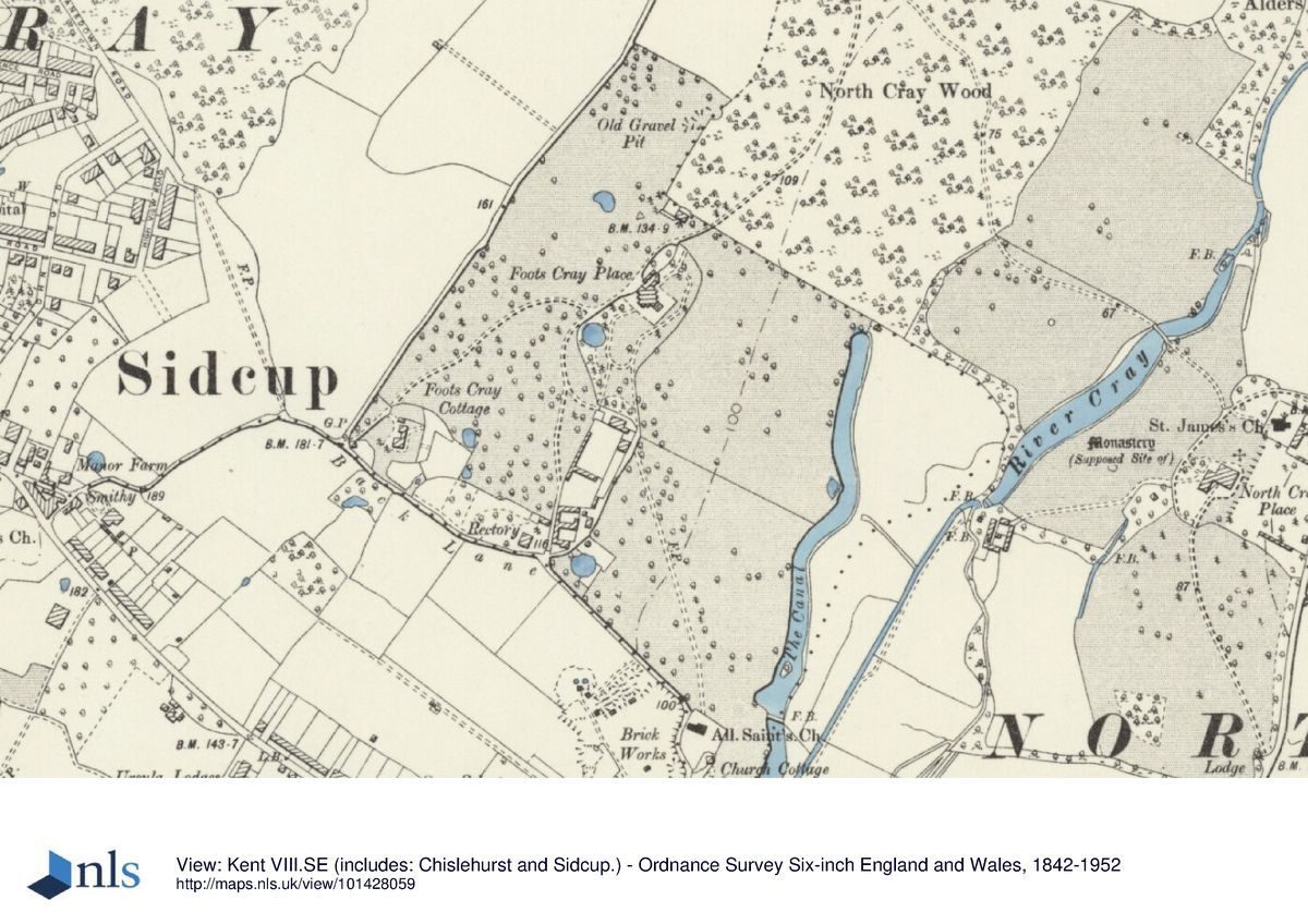
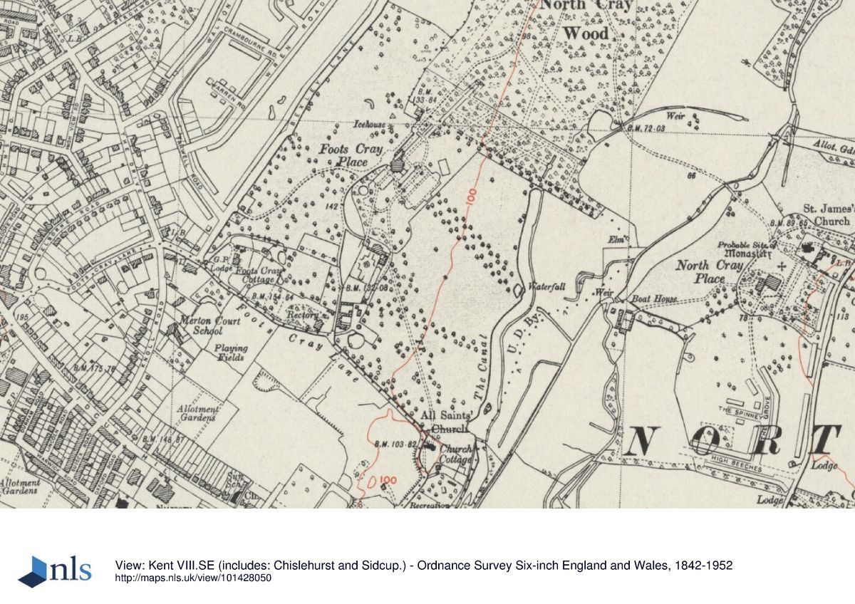
The site slopes down to the River Cray and Foots Cray Meadows to the east; towards the north of the park are the remains of North Cray Wood.www.historicengland.org.uk/listing/the-list
A site consisting of two mid C18 landscape parks incorporated into one estate in the early C19 then subsequently re-divided. The gardens around Foots Cray Place were laid out to the design of William Sawrey Gilpin in 1822-3 and redesigned by Thomas H Mawson in 1903.
DESCRIPTION
LOCATION, AREA, BOUNDARIES, LANDFORM, SETTING
The 89ha site of Foots Cray Place lies between the old settlements of Foots Cray and North Cray. It is bounded to the north-west and south-east by residential developments and schools; to the south by an industrial complex; to the south-west by Rectory Lane; to the north-west by Bexley Lane; and to the east by North Cray Road.
The site slopes down to the River Cray and Foots Cray Meadows to the east; towards the north of the park are the remains of North Cray Wood. The ground to the north-west, although now school playing fields, retains some mature trees from Foots Cray Place.
ENTRANCES AND APPROACHES
Between 1822 and 1823, William Sawrey Gilpin moved the entrance from the south side to the north side of Foots Cray Place, and changed the approach drive from north-north-west to south-west with the entrance at the corner of Rectory Lane and Bexley Lane. This approach was shared with Foots Cray Cottage, now the Dower House. The main vehicular entrance is now (1997) to the south of this along a small road off Rectory Lane, south-east of the Rectory. This passes the Bowling Pavilion (listed grade II) and the site of the long narrow bowling green, designed by Thomas Mawson, to the west, and open parkland to the east. The track terminates in a car park to the north of the coach house/stable block (listed grade II) and the walled garden (listed grade II). There are numerous other access points around the grounds which are mainly unfenced.
PRINCIPAL BUILDING
Both mansions have been demolished but the C18 coach house/stable block (listed grade II) for Foots Cray Place survives to the south-west of the site of the mansion, against the north-east side of the walled garden.
GARDENS AND PLEASURE GROUNDS
William Sawrey Gilpin's realigned drive survives in part as a footpath from the car park north of the stables, and leads west and then north past the site of the mansion and the pleasure grounds. Some 25m further to the north are, on the east side of the path, two small cast-iron gateposts leading to the remains of a stepped walk and an area, now (1997) overgrown, which Thomas Mawson designed as an open glade. A few metres further, on the east side of the track, a single tall C19 brick gate pier survives; the relict drive continues to become a path through the remains of North Cray Wood and the block of woodland referred to as the 'Coppice' in the mid C18, when it was laid out with a network of winding gravel paths. Although mostly built over in the mid C20, North Cray Wood retains, to the south-east, its C18 outline and some old coppiced trees survive in the 'Coppice'.
A school has been built over an area of park to the north of the drive but the adjoining playing field retains some mature trees and remains of boundary planting survives alongside Bexley Lane.
To the south of the relict drive, below the level of the site of the mansion of Foots Cray Place, are the remains of three terraces originally designed by Sawrey Gilpin and which were substantially remodelled by Thomas Mawson when he was employed by Samuel Waring in 1903. The area is now partially overlain with rubble from the demolition of the house, particularly to the north and west. Part of the outline of the house can be traced on the upper grass terrace, its entrance flanked by a pair of yew trees. Some 20m to the south-west of the site of the mansion is a stone base, probably of a fountain but labelled as a 'figure' on Mawson's plan of Foots Cray Place published in 1926 (Mawson). The narrow middle terrace still has trees at either end. The third and lowest terrace, on which was the tennis court and croquet lawn, is bounded by yews and retains the apsidal ends shown on Mawson's plan. The central vista is focused on the remains of a late C19 double lime avenue which runs south-east for 300m to the line of an C18 canal. To the north, east, and south of the terraces there is open ground with views to All Saints' church to the south-east. The housing developments to the north-west are screened by North Cray Wood and those to the east by boundary plantings.
A double avenue of apple trees (now gone) were planted as part of Mawson's design, to link the canal with his bowling green, laid out alongside the east wall of the walled garden. At the northern end of the narrow green stands the two-storey Bowling Pavilion (listed grade II) designed in 1903 by R Frank Atkinson.
PARK
The land to the north, east, and south of the pleasure grounds slopes towards the River Cray where the remains of the parkland of North Cray Place joins the parkland of Foots Cray Place and is now known as Foots Cray Meadows.
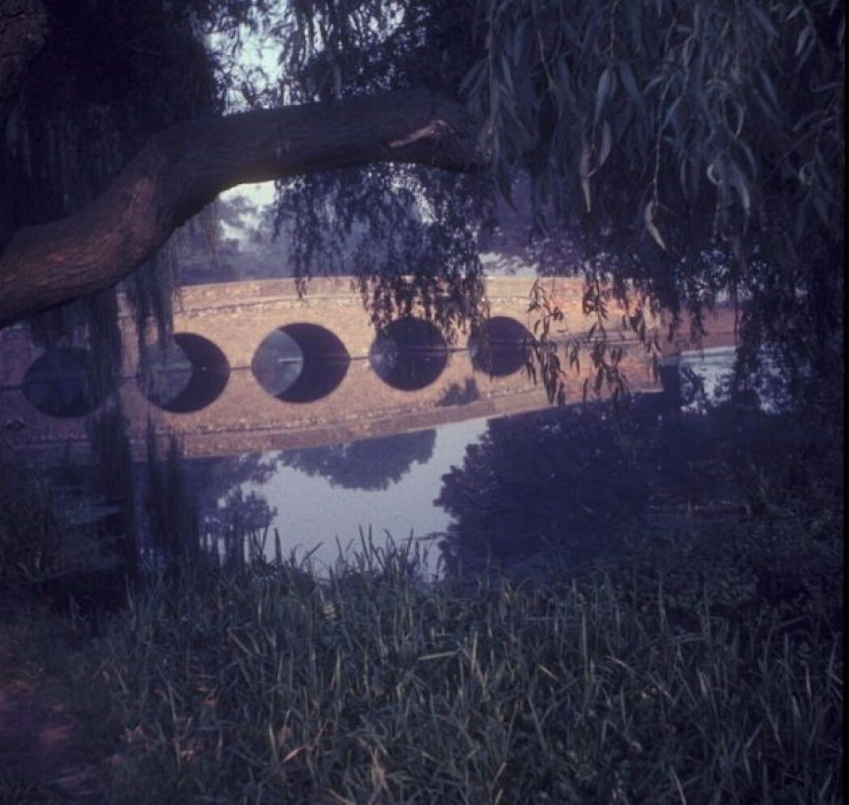
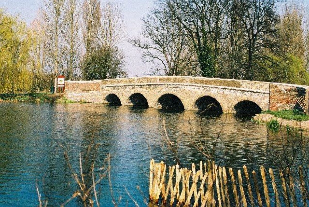
The land around the C18 North Cray Place was laid out as a landscape park, probably by Lancelot Brown, in the mid C18. The River Cray was widened to form the long, ribbon-like lake which ran from south-west to north-east across the centre of the park. The river is crossed at the north end of the lake by an C18 five-arched bridge cum dam (listed grade II). Scattered mature trees survive in the parkland and may also date from this period.
A lawn leads down from Foots Cray Place to the site of a serpentine canal to the north-west of the River Cray. The canal ran north/south across the park, passing close by the end of the C19 lime avenue and terminating at the southern end of the site. The single-arched bridge which spanned the south end of the canal has gone, but the footings are thought to survive below ground level, perhaps buried when the canal was filled in during the Second World War. The outline of the canal is still discernable and some mature parkland trees survive. All Saints' church provides a point of interest to the south from the end of the lime walk.
KITCHEN GARDEN
The two mid C18 walled kitchen gardens lie to the south-west of the coach house/stable block. The main access is to the north-west of the stables, through C18 ornate wrought-iron gates mounted on rusticated brick piers with stone caps and balls. The gates and the external brick walls, between 1.5m and 3m high, are listed grade II, and there are three other gateways in the walls.
Mawson redesigned the northern garden and gave it a more ornamental aspect, dividing the main section into four plots with a central fountain, the base of which survives screened by an overgrown yew hedge.
The east/west wall between the two gardens incorporates the 'Smoking House' built into the north-facing side. The southern walled garden appears, according to Mawson's plan, to have retained its function as a kitchen garden. The raised terrace to the west supported small cultivated plots, and the ground to the east, larger square or rectangular areas divided by straight paths. Today (1997) the raised terrace and cross-paths survived as grassed areas. A gate in the south wall leads to the Bowling Pavilion.
REFERENCES
Society of Gentlemen, England Displayed 1, (1769), p 144
G A Walpoole, New British Traveller (1784), pl after p 22
H Boswell, Historical descriptions of new and picturesque views (1800)
J P Neale, Views of the Seats ... 2nd Sers 4, (1828)
G Virtue, Picturesque beauties of Great Britain: Kent (1829), p 2
W H Ireland, History ... of Kent 4, (1830), p 524
Architectural Review 9, (1901), p 267; 27, (1910), pp 102-4
Building News 87, (1904), p 684, pl 4; 92, (1907), pp 848-9
J Roy Horticultural Soc 34, (1908-9), p 376, fig 67
Studio Year Book, (1906), p 257; (1907), p 183; (1913), p 125; (1917), pp 10, 54
The Architect 77, (1907), p 364
Architectural Record 30, (1911), p 346
T H Mawson, The Art and Craft of Garden Making (5th edn 1926)
T H Mawson, The Life and Work of an English Landscape Architect (1927)
S Piebenga, William Sawrey Gilpin, (English Heritage Designer theme study 1994)
Maps
Sale particulars for Foots Cray Place, 1822 (Bexley Local Studies Library)
Tithe map, 1840 (Centre for Kentish Studies)
Estate plan of Foots Cray Place, 1854 (Bexley Local Studies Centre)
OS 25" to 1 mile:
1st edition published 1868
1916 edition
1938 edition
Description written: September 1997
Register Inspector: LCH
Edited: June 2001
- Visitor Access, Directions & Contacts
Access contact details
Opening is unrestricted.
Directions
Rail: Albany Park, Sidcup. Bus: 492, B14.
Owners
London Borough of Bexley
- History
The following is from the Register of Parks and Gardens of Special Historic Interest. For the most up-to-date Register entry, please visit the The National Heritage List for England (NHLE):
www.historicengland.org.uk/listing/the-list
HISTORIC DEVELOPMENT
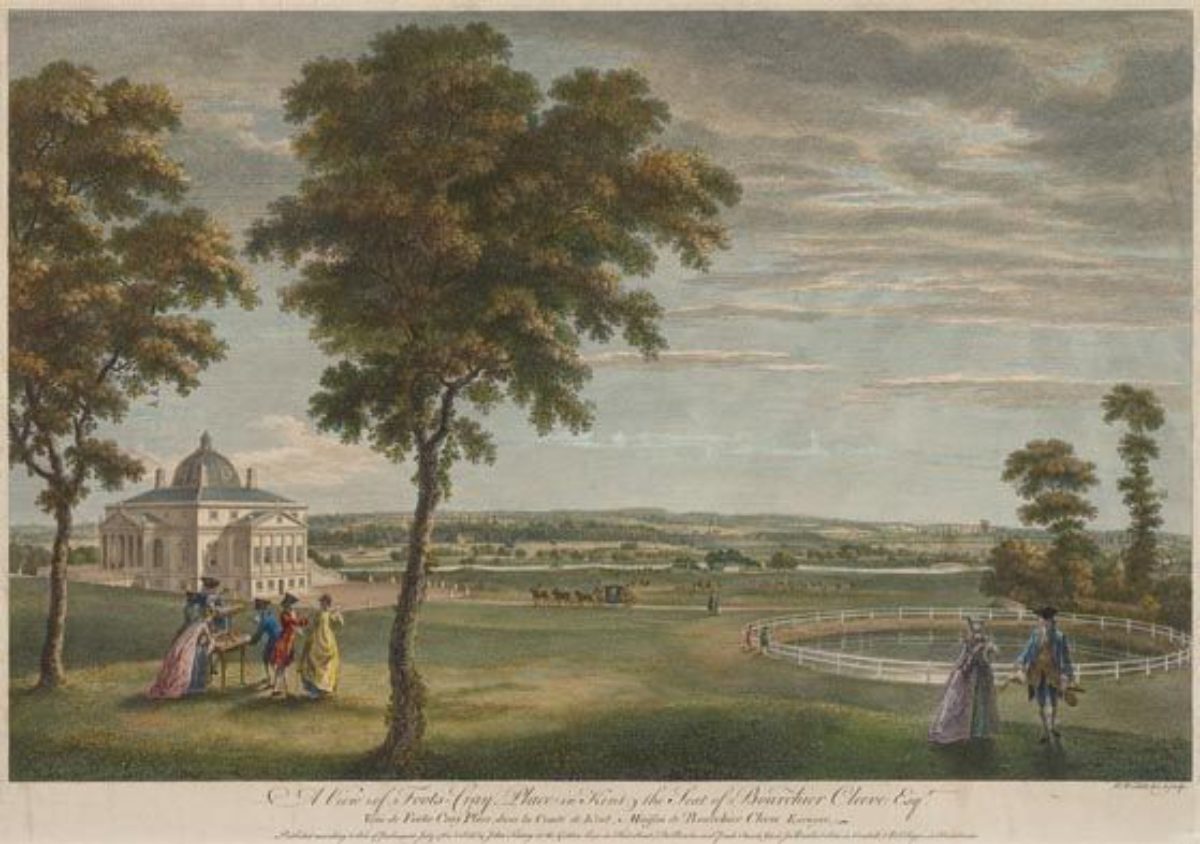
Foots Cray Place was built c 1754 for Bourchier Cleeve, a pewterer and financier who had bought the estate two years earlier. The design, attributed to Isaac Ware, was based on Palladio's Villa Rotunda. The new mansion replaced the medieval manor house, Pyke Place, which stood adjacent to All Saints' church at the southern end of the site, and which was demolished in the late C18. Nicholas Vansittart, Chancellor of the Exchequer acquired Foots Cray Place in 1822, and also purchased the adjoining estate, North Cray Place, eleven years later. Between 1822 and 1832 Vansittart employed William Sawrey Gilpin (1762-1843) to make improvements to the joint estate. His alterations are recorded on the 1840 Tithe map.
The North Cray Place estate covered an area to the east of the River Cray, the surviving parkland now (1997) known as Foots Cray Meadows. Lancelot Brown (1716-83) was involved in the development of North Cray Place, receiving £1300 from the then owner, Mr Coventry, a Sub-Governor of the South Sea Company, in 1771.
North Cray Place stood next to the parish church on the eastern boundary of the present registered site. It was rebuilt in the early C19 and, after being damaged in the Second World War, was demolished in 1962, the site built over and the surviving parkland (Foots Cray Meadows) reunited with Foots Cray Place.
The early C19 property of Foots Cray and North Cray was subdivided later in the century and in the late 1890s Foots Cray Place and most of its original land was let to Simon Waring, who purchased it in 1912 and lived there until the early 1930s. In 1903 Waring called in Thomas H Mawson (1861-1933) who, according to his plan published in 1927 (Mawson), elaborated on the design of Sawrey Gilpin. Waring carried out Mawson's proposals in stages but it would appear that the design was never fully implemented. Waring died at the beginning of 1940, by which time the Royal Naval Training establishment, HMS Worcester, occupied the house.
In 1946 the house was bought by Kent Education Committee for use as a museum, but three years later it was damaged by fire and pulled down. A major part of the site is now (1997) a public open space managed by the London Borough of Bexley.
- Associated People
- Features & Designations
Designations
The National Heritage List for England: Register of Parks and Gardens
- Reference: GD1216
- Grade: II
Features
- Ornamental Bridge
- Description: Five Arch Bridge
- Stable Block
- River
- Description: River Cray
- Key Information
Type
Park
Purpose
Recreational/sport
Principal Building
Parks, Gardens And Urban Spaces
Survival
Part: standing remains
Hectares
97
Open to the public
Yes
- References
References
- {English Heritage Register of Parks and Gardens of Special Historic Interest} (Swindon: English Heritage 2008) [on CD-ROM] Historic England Register of Parks and Gardens of Special Historic Interest
- Mawson, T H {The Life and Work of and English Landscape Architect} (1927) The Life and Work of an English Landscape Architect
- {Foots Cray Meadows Restoration Plan} (1997) Foots Cray Meadows Restoration Plan
Contributors
London Parks and Gardens Trust